Skip to main contentSkip to main content
Register for more free articles.
Log in Sign up
Back to homepage
Subscriber Login
Keep reading with a digital access subscription.
Subscribe now
You have permission to edit this collection.
Edit
Arizona Daily Star
69°
  • Sign in
  • Subscribe Now
  • Manage account
  • Logout
    • Manage account
    • e-Newspaper
    • Logout
  • News
    • Sign up for newsletters
    • Local
    • Arizona
    • Business
    • Crime
    • Nation & World
    • Markets & Stocks
    • SaddleBrooke
    • Politics
    • Archives
    • News Tip
  • Arizona Daily Star
    • E-edition
    • E-edition-Tutorial
    • Archives
    • Special Sections
    • Merchandise
    • Circulars
    • Readers' Choice Awards
    • Buyer's Edge
  • Obituaries
    • Share Your Story
    • Recent Obituaries
    • Find an Obituary
  • Opinion
    • Submit a Letter
    • Submit guest opinion
    • Letters to the Editor
    • Opinion & Editorials
    • National Columnists
  • Sports
    • Arizona Wildcats
    • Greg Hansen
    • High Schools
    • Roadrunners
  • Lifestyles
    • Events Calendar
    • Arts & Theatre
    • Food & Cooking
    • Movies & TV
    • Movie Listings
    • Music
    • Comics
    • Games
    • Columns
    • Play
    • Home & Gardening
    • Health
    • Get Healthy
    • Parenting
    • Fashion
    • People
    • Pets
    • Travel
    • Faith
    • Retro Tucson
    • History
    • Travel
    • Outdoors & Rec
    • Community Pages
  • Brand Ave. Studios
  • Join the community
    • News tip
    • Share video
  • Buy & Sell
    • Place an Ad
    • Shop Local
    • Jobs
    • Homes
    • Freedom RV AZ
    • Marketplace
    • I Love A Deal
  • Shopping
  • Customer Service
    • Manage My Account
    • Newsletter Sign-Up
    • Subscribe
    • Contact us
  • Mobile Apps
  • Weather: Live Radar
  • Facebook
  • Twitter
  • Bluesky
  • YouTube
  • Pinterest
  • Instagram
© 2026 Lee Enterprises
Terms of Service | Privacy Policy
Arizona Daily Star
News+
Read Today's E-edition
Arizona Daily Star
News+
  • Log In
  • $1 for 3 months
    Subscribe Now
    • Manage account
    • e-Newspaper
    • Logout
  • E-edition
  • News
  • Obituaries
  • Opinion
  • Wildcats
  • Lifestyles
  • Newsletters
  • Comics & Puzzles
  • Buyer's Edge
  • Jobs
  • Freedom RV AZ
  • 69° Sunny
Share This
  • Facebook
  • Twitter
  • Bluesky
  • WhatsApp
  • SMS
  • Email

Collection: Read more from the 'Mine Tales' series

  • Arizona Daily Star
  • May 3, 2022
  • May 3, 2022 Updated Apr 25, 2023

Mine Tales: Arizona's minerals have proven vital in war and peace

Arizona has many historical mining properties that have produced gold, fluorspar, vanadium and uranium. These minerals have proven vital to many industries during times of war and peace.

The state also has iron ore deposits found in its central parts, including the banded-iron formation northwest of Prescott composed of quartz-hematite-magnetite rock formed from oxygenated ocean water 1.7 billion years ago.

The Gold Road Mine dates back to 1899 when it was discovered by Mexican gold prospector Jose Jerez while he was exploring Sitgreaves Pass west of Kingman. The discovery of a prominent quartz outcrop carrying gold led to further investment involving a Salt Lake City syndicate comprised of Col. O. P. Posey, Clarence K. Dimmick and William Bayley.

Development of the eight-foot-wide gold vein included a 150-ton cyanide plant, 150 miners and monthly bullion shipments of up to $15,000 by 1907. By 1931, the mine’s production totaled $7.3 million. Mining under Addwest Minerals in the 1990s saw an additional 92,500 ounces of gold production until reduced market prices forced a temporary closure.

Today the mine is operated by Gold Road Mining Corp., a subsidiary of Para Resources Inc., as an underground gold-silver mine with a surface milling facility.

Located on the western side of Agua Fria Canyon 4 miles east of Bumblebee, the Richinbar Mine operated sporadically from 1905 to 1922 under multiple companies with a total of $60,000 in low-grade gold ore produced. Geologically the vein crops out in granite at the edge of a basaltic mesa, with the gold ore occurring in irregular vertical shoots in coarse massive quartz. The mine included a 20-stamp mill and was developed with a vertical shaft 480 feet deep. Overall, the mine was a money pit and bad investment overall for the cost to operate it outweighed the profit.

The Swastika Mine, 5 miles north of Crown King in the Bradshaw Mountains, is noted as a rich silver producer when operated by diligent and intrepid owners and lessees. Early development began in 1876 by F.W. Curtin with hand tools, though the camp later had electricity. A 50-ton cyanide mill was started onsite in 1919. A 5-ton Garford truck was used for ore transport.

Between 1910 and 1915 the mine produced 600,000 ounces of silver and more than $3 million from 1934 to 1952. Index Mines operated the site in the mid-1970s, building onsite a leaching-electro-winning plant where limited gold and silver bullion and copper plating was produced.

Mine Tales

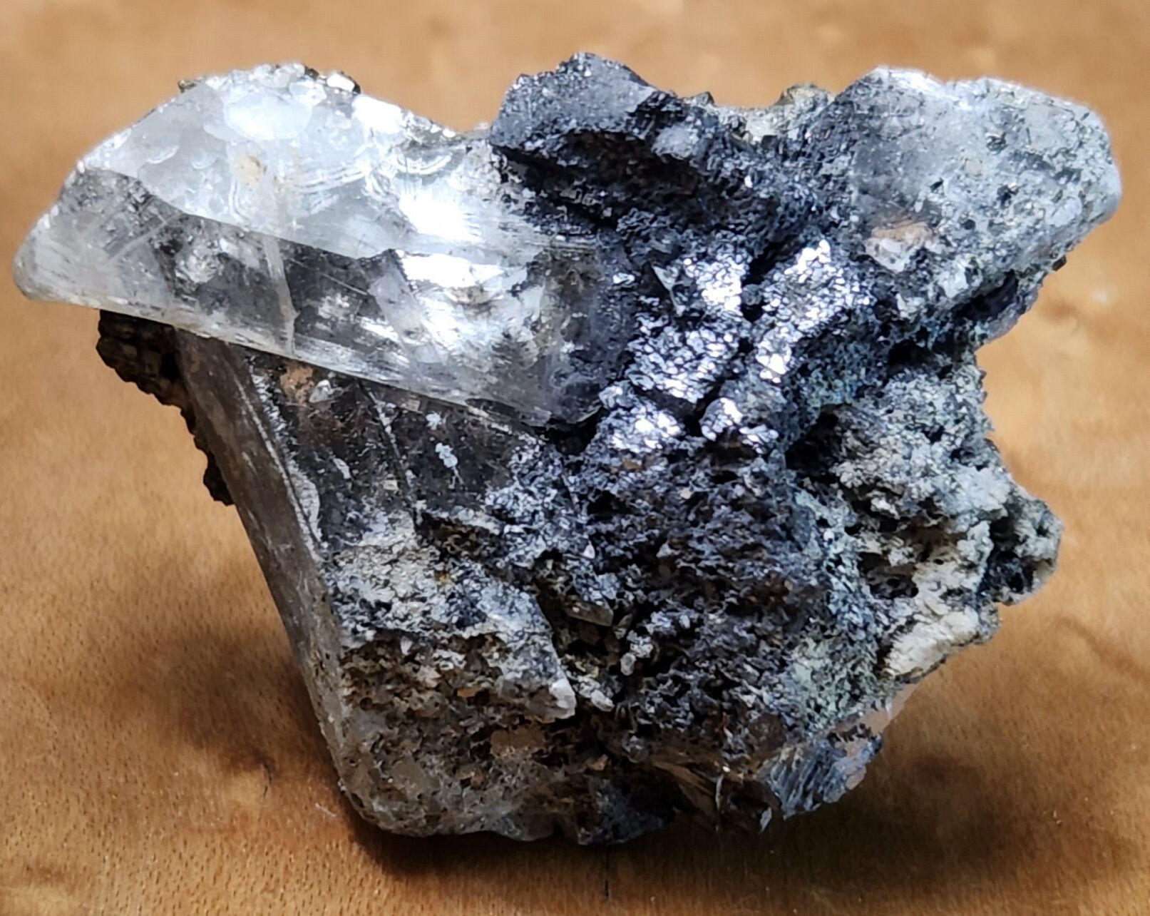
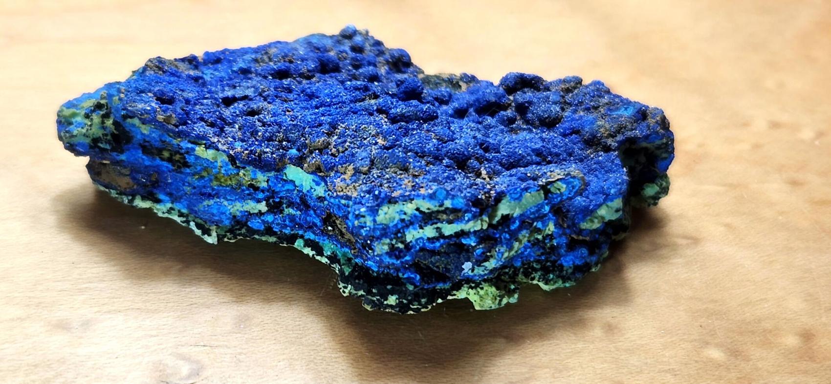
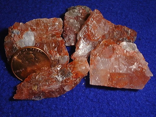
Thumbnail size mineral sample of fluorite with argentiferous galena from the Hull Mine.

William Ascarza

Mining at the Hull Mine, in the Castle Dome Mountains in Yuma County, dates back to 1867 when the first shaft was dug by J. Brown. He was attracted by a vein outcrop of fluorite, calcite and oxidized galena in an area of shale, limestone, and sandstone. Mineralization measured 2,000 feet in length and up to 12 feet in width.

Twenty years later, argentiferous galena ore was mined and shipped at profit, which became the trend during the mine’s sporadic ownership, development and production over the decades. This included a small concentrating plant and an experimental cyanide heap leach operation that economically failed to recover silver from the mine’s lead-silver ore.

Interest in the mine was revived with the goal of extracting fluorspar for commercial profit. Fluorspar is an important component in hydrofluoric acid necessary in the refrigeration and air conditioning industry.

Mineral collectors have long appreciated the mine’s output of specimens including fluorite, barite, wulfenite and cerussite on galena found at the 200-foot level.

The Hamburg Mine in the Silver Mining district near Yuma began in the 1870s as a vein system mined for silver, with later exploration conducted by Silver Glance Resources Inc. in an early 1990s drilling program revealing significant fluorite assays.

Vanadium is a metal in Arizona that occurs as vanadinite, a chloro-vanadate of lead formed by the oxidation of lead sulfides in sedimentary rocks. Several uses of vanadium include its application as an alloy in the steel industry and its use in renewable energy in vanadium flow batteries as energy storage.

Although Arizona is not a significant producer of vanadium, deposits exist across the state, including those from the Tiger Mine in the historic Mammoth mining district, the Gallagher Mine in the Tombstone mining district, and in a vein deposit in quartzite at the Apache Mine north of Globe-Miami.

The Gallagher Mine near Charleston, about 8 miles southwest of Tombstone, was developed as a series of silver-lead ore claims sunk between 12 and 200 feet in depth. Credit is given to J.B. Gallagher, the mine’s namesake, for having discovered vanadium and molybdenum ores on the property.

The mine’s geology includes rock mass tertiary andesite flow intruded by a rhyolite dike carrying considerable mineralization including lead, gold, silver, vanadium and molybdenum.

Arthur L. Flagg served as the consulting engineer to the Gallagher Vanadium and Rare Metals Corp., stating the deposit hosted the greatest variety of vanadium minerals in the Southwest. Consisting of 22 claims with considerable drifting, production from 1929 to 1953 was minimal, including 670 tons of lead ore shipped to the El Paso Smelter for refinement. Although an onsite mill was never built, it was recommended due to the large amount of milling ore surrounding the main vein.

Mine Tales

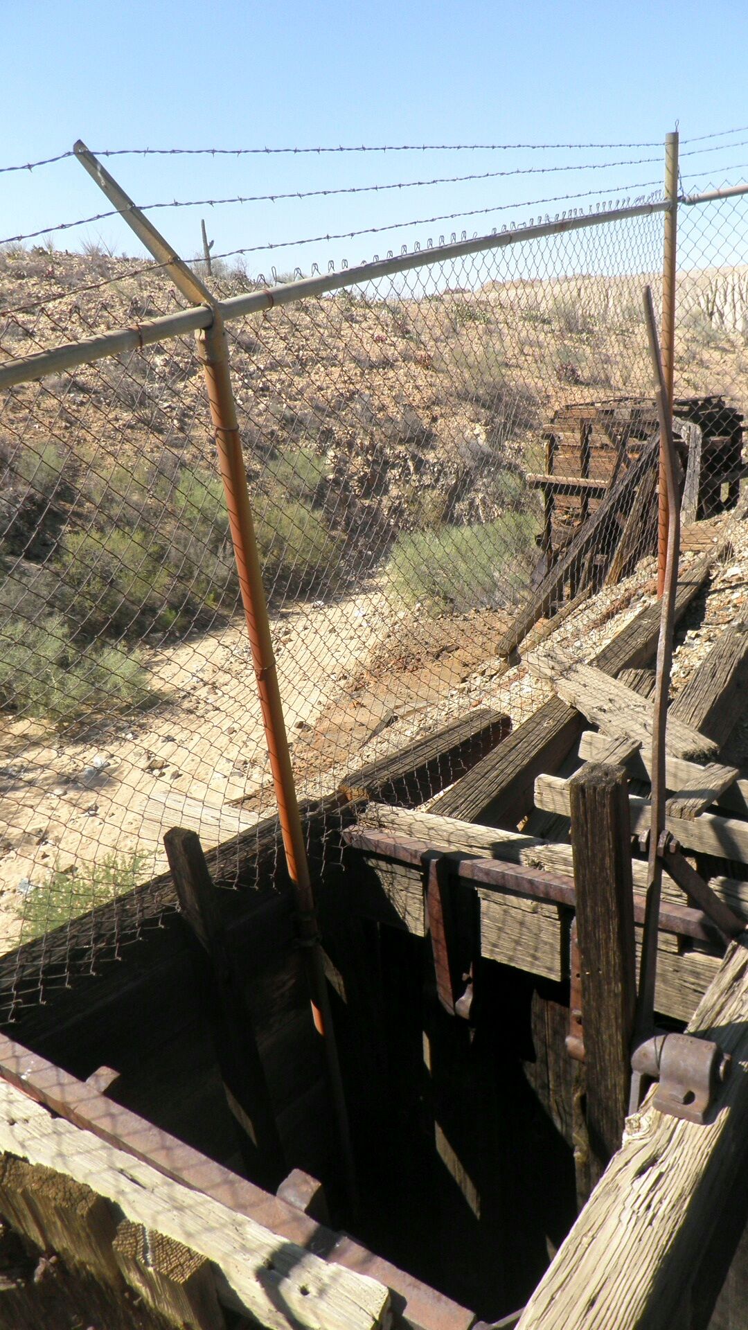
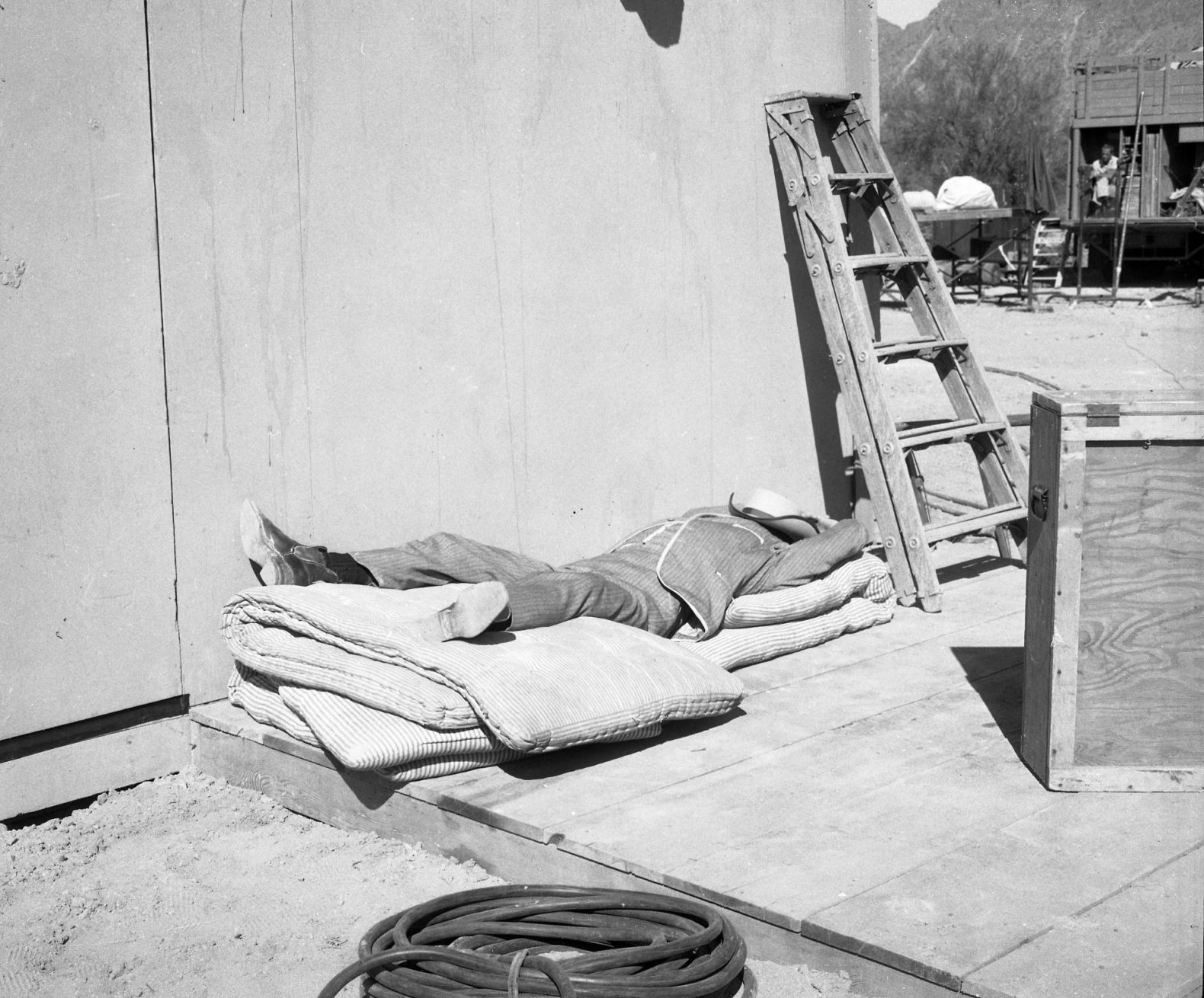
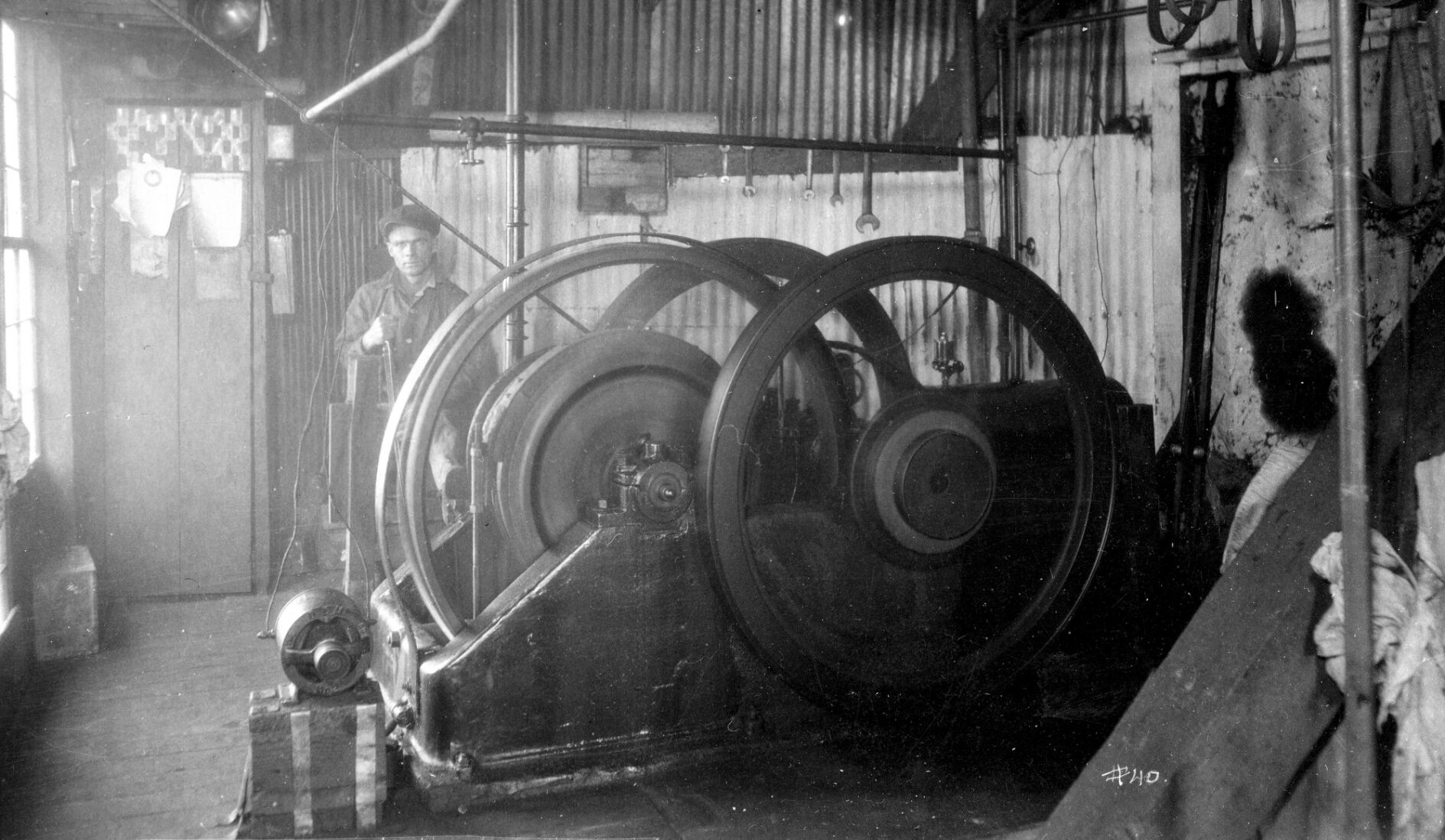
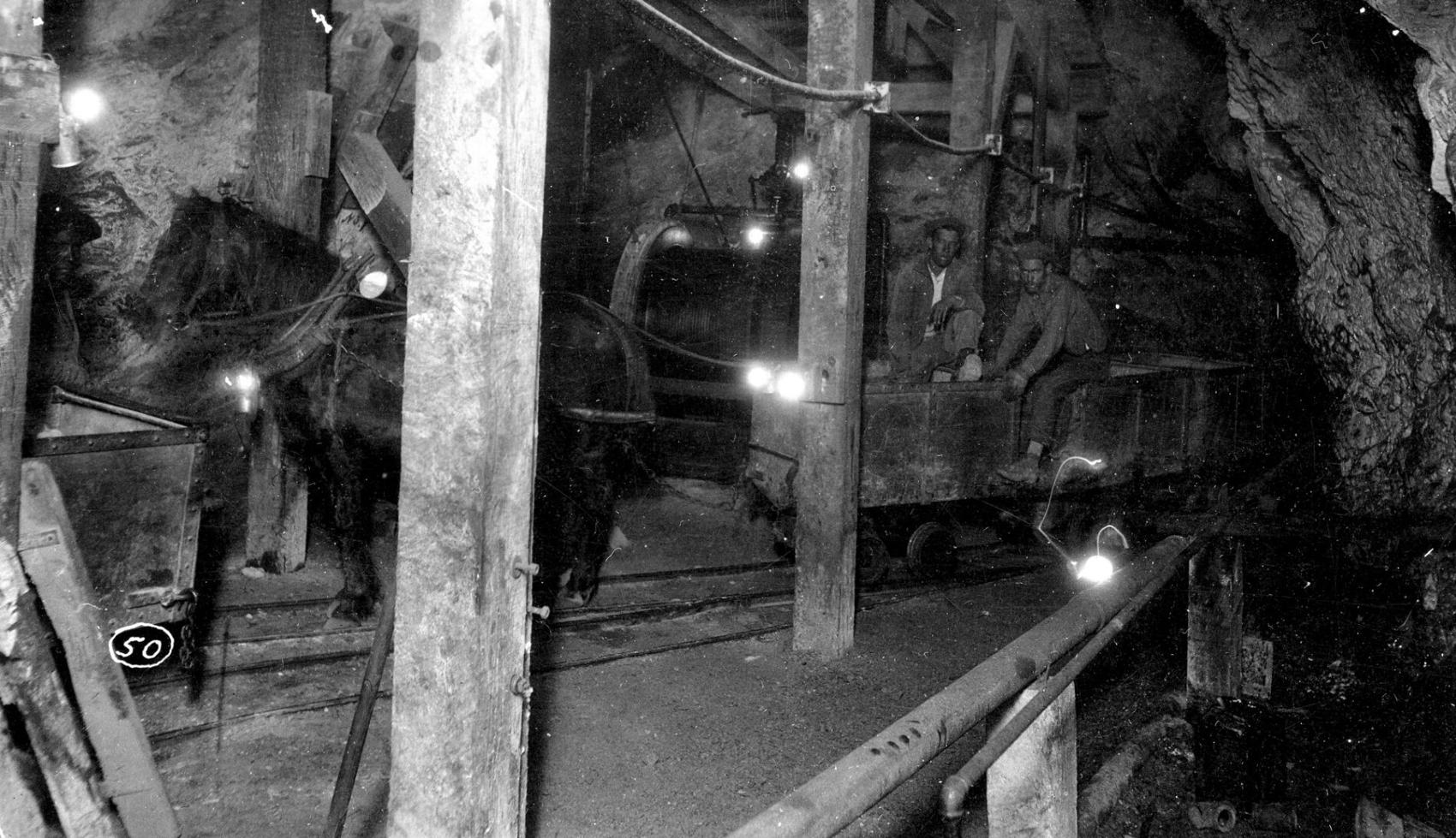
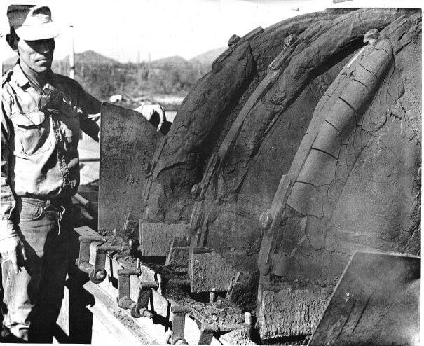
Wooden structures and equipment at the Anderson uranium mine in Yavapai County.

Courtesy of Arizona Geological Survey

The Anderson mining claims 43 miles northwest of Wickenburg, also known as the Uranium Aire claims , were discovered by accident in 1955 by T.R. Anderson during an aerial survey using an airborne scintillation counter. Anderson developed 130 claims with labor from his paint contracting firm in California.

The geology of the area includes detrital rocks with a portion of bentonitic clays, light-colored Tertiary volcanic tuffs with a mineralized outcropping for several thousand feet, including pods of exceedingly rich uranium ore. Uranium was precipitated in portions of lake beds with organic carbon particles from carbonate-rich solutions. The ore is carnotite in petrified palm roots up to 2 feet in diameter.

By 1957 the mine was developed as a small open pit with four trucks producing 150 tons of uranium ore averaging 0.4% per week. Production was 33,230 pounds of U308 from 1955 to 1959 until the Atomic Energy Commission ended its ore purchasing program. Ore was shipped to Tuba City, Arizona and Grants, New Mexico for refinement.

Getty Oil Co. leased the property with an option to purchase in 1968. Having conducted an extensive drilling program, it moved on to more lucrative uranium properties in Wyoming. Later attempts to develop the large low-grade uranium ore body included over 1,400 drill holes involving the exploration efforts of Union Oil Co., Minerals Exploration Co. and Urangellschaft U.S.A. Inc.

The Anderson Mine is currently owned by Uranium Energy Corp. or UEC. The property encompasses 8,268 acres with a total proven reserve from 25 million to 27 million pounds of uranium.

This is the third of our history quizzes. How much do you know?

Johanna Eubank

Mine Tales: The history of mining in Tucson-area mountain ranges

Many mountain ranges near Tucson have significantly contributed to Arizona’s mining history. These include the Sierrita, Silver Bell, Patagonia and Santa Rita Mountains, which have a similar geological origin.

They were formed by a volcanic caldera cycle involving the creation of volcanic peaks from underground magma chambers and distributed by basin and range detachment faulting.

The rugged and remote Sierrita Mountains have been mined for centuries by Spanish explorers and missionaries for silver-lead deposits and more extensively for copper in the mid-20th century at operations, including the Mission Mine Complex and the Twin Buttes open pit mine. Geologically the Sierrita Mountains consist of an intrusive granitic core surrounded by metamorphic rock.

Mine Tales: Mines and Mountains around Tucson

The Senator Morgan Mine workings seen in 2012.

William Ascarza

The Sierritas are one of the few localities in Arizona that host aquamarine found in quartz veins in granite. The mountains encompass 60 square miles measuring 12 miles north to south and up to six miles wide. Aquamarine, a gem variety of beryl, has been documented from the Palo Verde and Bella Donna claims. The location of these claims remains unknown as they have never been patented.

Other mines in and nearby the Sierrita Mountains include the Copper Glance Mine in the Twin Buttes Mining district, which had its own railroad spur for ore transport; along with the Senator Morgan Mine, worked for copper since the late 1870s.

Operated by the Twin Buttes Mining & Smelting Co., established in 1903, the Senator Morgan Mine was leased to Bush-Baxter from 1906 and 1913. It was extensively developed and stopped with a shaft depth of 900 feet and a production of 152,000 tons of copper ore valued in conjunction with silver extracted at over $2 million. Scheelite, an ore of tungsten (WO3), was later found in quartz deposits along with lime and silicified sandstone.

Mine Tales: Mines and Mountains around Tucson

A small cabinet size sample of jackstraw cerussite from the Flux Mine in the Patagonia Mountains.

William Ascarza

In 1942, Maurice d’ Autremont and David Richards leased the property from Charles M. Taylor, who discovered scheelite in disseminated quartz veins using a fluorescent lamp the prior year. They shipped more than 100 tons of ore to the Jacobs tungsten mill, northwest of the intersection of Speedway and Silverbell, 2 miles west of downtown Tucson, for testing. Low-grade values at 1.25% and faulted conditions in the geology necessitated greater mining costs, hindering ore production, and no further work was done after 1943.

The Silver Bell Mountains west of Tucson host the large Silver Bell Open Pit Mine. The formation of Silver Bell’s copper deposits dates back 75 million years. They were created by intense volcanic activity, causing the accumulation of thick layers of volcanic debris and magma chambers to form at great depths below the surface. As the magma solidified, copper-rich fluids were ejected and channeled to the surface along a fault zone spread out along a network of fractures, forming the current deposition of copper minerals.

Mining in the area is extensive and began with the discovery of high-grade oxidized copper ore at the Old Boot Mine in 1865. The arrival of the Southern Pacific Railroad 15 miles to the southwest in 1881 heightened development, with a 30-ton-per-day furnace built onsite by the Huachuca Mining and Smelting Co.

A decade later, the Silver Bell Mining Co. erected a small Tucson smelter that refined the mine site’s ore for several years.

By 1903, the Imperial Copper Co. was organized by E.B. Gage and W.F. Staunton, along with the Development Co. of America or DCA, created in 1901 to finance and oversee a network of mining and railroad operations in Arizona by magnate Frank M. Murphy.

Mine Tales: Mines and Mountains around Tucson

A small cabinet size sample of azurite from the Exchange Mine nearby Helvetia in the Santa Rita Mountains.

William Ascarza

Soon established, the Silver Bell townsite reached a population of around 1,000. And by 1909, the Southern Arizona Smelter Co. (SASCO) established the company town of Sasco and a smelter west of Red Rock to process the ores of the Silver Bell Mine. The town and smelter were short-lived due to the bankruptcy of DCA involving its mining operations in Tombstone, the Spanish flu pandemic, and falling copper prices.

Dropping copper prices also forced ASARCO to suspend operations at the nearby Silverbell Mine. The mine was developed by ASARCO in 1951, including two ore bodies, El Tiro Pit and Oxide Pit, separated by two and one-half miles. Copper production continues to the present.

The Helvetia Mining district, 30 miles southeast of Tucson in the northern end of the Santa Rita Mountains, includes more than 50 mines and prospects worked sporadically since discovery in the 1870s.

By 1899, the mining camp of Helvetia was one of the largest in Pima County, with more than 300 miners on the payroll of the Helvetia Copper Co. and development occurring at the Copper World, Exchange, Heavy Weight, Isle Royal, Narragansett and Omega mines.

Mine Tales: Mines and Mountains around Tucson

Thumbnail size sample of aquamarine, muscovite and quartz from the Sierrita Mountains.

William Ascarza

Despite extensive development, including an 8,000-foot narrow gauge railroad connecting the mines in the Helvetia district to a 175-ton smelter, the mines themselves never produced significant profit, though at one time, they were on the map to receive a branch railroad from the Southern Pacific. Today, the mines are of interest among mineral collectors for the specimens they produced.

The Flux Mine in the Harshaw Mining district, four miles south of Patagonia, was a steady producer of lead and zinc from 1884 to 1963. The mine was first discovered in the 1850s and was owned and optioned with greatest production (over $3 million in period dollars) since 1940 under ASARCO.

In 1919 a 6,200-foot-long aerial rope tramway connected the mine to the 100-ton daily capacity gravity-flotation concentrating mill capable of processing lead carbonates. The operation was financed by the Flux Syndicate and lasted only several years due to high operational costs. Four thousand tons of ore and tailings were milled, producing 14 carloads of lead and silver concentrates at period markets for $16,000.

Geologically, the mine consists of rhyolite porphyry and related volcanic sedimentary deposits. The mine reached the 750-foot level, including more than 6,000 feet of tunnels, shafts, drifts, crosscuts and stopes, after which it became too low grade to profit from the metals market. The lead concentrates were shipped by rail to the El Paso smelter, and the zinc concentrates were shipped to the Amarillo smelter.

Mine Tales: Mines and Mountains around Tucson

Thumbnail size sample of fluorite with galena from the Silver Bell Mine.

William Ascarza
Mine Tales: Mines and Mountains around Tucson

Fluorite drill core sample from the Silver Bell Mine.

William Ascarza
Mine Tales: Mines and Mountains around Tucson

Micromount size sample of garnet from the Silver Bell Mountains.

William Ascarza
Mine Tales: Mines and Mountains around Tucson

Small cabinet size sample of pyrite on alaskite matrix from the North Silver Bell Pit in the Silverbell Bell Mountains.

William Ascarza
Mine Tales: Mines and Mountains around Tucson

A glass mine insulator such as this one patented in 1894 by Hemingray was commonly used to prevent electric current loss of transmission in mining operations during the early 1900s including those at Silver Bell. A threaded hole through the middle allowed a malleable iron pin to drain excess water frequently encountered inside mines preventing freezing and short circuiting the attached electrical lines.

William Ascarza
Mine Tales: Mines and Mountains around Tucson

A thumbnail sample of malachite after azurite/calcite from the Omega Mine in the Santa Rita Mountains.

William Ascarza
Mine Tales: Mines and Mountains around Tucson

A thumbnail size sample of the lead and manganese mineral coronadite named after the Spanish Explorer Francisco Vasquez de Coronado from the Glove Mine located in the Tyndall Mining District on the southwestern flank of the Santa Rita Mountains.

William Ascarza
Mine Tales: Mines and Mountains around Tucson

A distant view of the Senator Morgan Mine with the Twin Buttes Mine tailings in the background circa 2012.

William Ascarza

Get your morning recap of today's local news and read the full stories here: tucne.ws/morning

Mine Tales: Mining district near Tombstone busy for decades

The towns of Gleeson and Courtland along the old ghost town trail have an extensive history of mining operations.

They are located three miles apart in the Turquoise Mining district in the southeastern part of the Dragoon Mountain Range, about 15 miles east of Tombstone. The range itself extends northwesterly with a length of 26 miles and a width up to 12 miles.

Geologic activity in the district includes faulting and igneous intrusions. Rocks include quartz monzonite, granite and felsite. Principal ore deposits include copper, lead-silver and zinc. Turquoise can be found near the surface in stringers and lenses in altered granite and quartzite. Gleeson Ridge includes manganese deposits found in Pennsylvanian Naco limestone fractures.

This area was the site of early mining activities involving the Apache who worked the shallow surface deposits for turquoise and again by Anglo miners involved resurgence in turquoise mines sparked by a fashion trend involving the polished blue-green stone by the renowned Tiffany & Co. of New York. Silver-lead deposits were also worked around Gleeson.

John Collins is credited with having made the first mining claim in the district in 1877. Additional claims followed including those made by Josiah Bryant. The arrival of the Southern Pacific Railroad through Dragoon Pass in 1881 encouraged mining activity, though it was hindered in part by Apache raids until the surrender of Geronimo in 1886.

Timber for mining operations came in part from the Chiricahua Mountains 30 miles east. Water was secured from local wells averaging 30 to 100 feet deep, producing up to 15,000 gallons per day depending on the season.

Mine Tales: Turquoise Mining district

Bono store and saloon in downtown Gleeson once served as a supply center for miners in the area.

William Ascarza

Early production came from the Silver Bill and Gleeson mines classified as the Costello Group which included oxidized ore on the surface containing high-grade silver lead values along with limited gold and copper. Later production included the Tom Scott and Tejon mines.

A decline in silver prices in the 1880s led to the mining of oxidized copper ore deposits around Courtland.

By 1907, exploration and production in the district ran high due to activity among the Calumet and Arizona, Great Western and Phelps Dodge mining companies.

Christened after Courtland Young, one of two brothers who owned the Great Western Copper Mining Co., the town of Courtland was short-lived. It operated from 1909-13, when the shallow copper mines played out at several hundred feet below the surface.

At the height of their mining activity in 1910 both towns included a combined population of 1,500.

The nearby Germania Mine operated by the Calumet & Arizona Mining Co. and Phelps Dodge Corp. produced 76,500 tons of copper ore between 1909-40. The mine developed to a 500 foot main shaft later submerged by flood water.

Early transportation proved challenging as the town of Cochise, 30 miles north by wagon, was the nearest railhead to the Southern Pacific Railroad for shipping.

Mine Tales: Turquoise Mining district

Looking east at mine tailings on Gleeson Ridge with remnants of old Gleeson School at base and the headframe and the water tower of the Copper Belle Mine, ca 2014.

William Ascarza

By 1909 two railroads arrived to service the district hauling ore and passengers including the Arizona Eastern from Cochise and the El Paso and Southwestern from Douglas. The latter focused on hauling ore to the Douglas smelter for refinement 40 miles southeast.

Both encouraged greater copper production until being decommissioned 20 years later due to a decline in the local mines.

The Copper Belle Mine was the largest mine around Gleeson having been discovered by the town's namesake Irishman John Gleeson in 1896.

Gleeson’s mining experience involved the silver mines of the San Juan Mountains in Colorado.

Within five years the Copper Belle (Leonard, deposit) produced $280,000 gross profit with ore averaging 5 percent copper. Attempts to process ore onsite included roasting the sulfides in pits with juniper and later by copper furnaces with a capacity of 70 to 350 tons daily.

Mine Tales: Turquoise Mining district

Thumbnail size specimen of wulfenite from the Defiance Mine northeast of Gleeson.

William Ascarza

Later attempts in 1923 involved setting fire to mine works in the attempt to consistently burn sulfide ore bodies, followed by flooding the workings with water to dissolve the copper sulfates. Finally water would be pumped out and passed over iron scrap to precipitate the copper from the solution.

A more successful venture involved shipping the ore by a 30-mile wagon-haul to the railhead at Cochise for shipment to the Clifton smelter.

By 1907, the Shannon Copper Co. acquired the property from Gleeson for $100,000 and by 1922 had a documented 305,000 tons of ore haulage for refinement at Clifton.

The Defiance Mine on the southwest slope of Gleeson Ridge worked intermittently since the 1880s yielded 300 tons of ore containing 8-14% lead, some zinc and up to 7 ounces of silver per ton.

Workings include 440 feet of drifts and two 100 foot deep winzes. By 1958 it was credited with 10,000 tons of ore production.

Originally owned by Martin Costello who operated many mines in the area, it was augmented into the Calumet & Arizona Mining Co. as part of the Costello Group.

The Silver Bill Mine dates back to the rich oxidized silver-lead ore mined from shallow workings in the 1880s, later developed with a 271-foot inclined shaft and several hundred feet of workings in the 1890s. At the 200-foot level the mine connected by tunnel to the workings of the nearby Mystery Mine.

Up to 1,900 tons of ore per month — averaging 10 ounces of silver per ton — was shipped to the El Paso smelter for refinement. Owned by the Gleeson Heights Minerals Co., it was the last major operational mine in the district, closing in 1978.

Production history in the Turquoise Mining district from 1883 through the early 1970s included a minimum of 887 thousand tons of base metal ore including copper, lead and zinc and 250 tons of manganese ore along with turquoise and quartzite smelter flux.

The district produced notable specimens of wulfenite found at the Defiance and Silver Bill mines. Like other renowned wulfenite mine sites in Arizona including the Tiger, Hilltop, Rowley, 79 and Red Cloud mines those at Gleeson have distinct crystal formation and are highly collectable in today’s mineral market.

At present, the district hosts over 250 patented mining claims and is becoming more developed as a residential area.

While the mines played out decades ago, the potential remains for previously undiscovered lucrative mineral deposits and profit from existing tailings piles.

Mine Tales: Turquoise Mining district

Small cabinet size specimen of wulfenite from the Silver Bill Mine northeast of Gleeson.

William Ascarza
Mine Tales: Turquoise Mining district

Micromount size specimen of pyrolusite from the Germania Mine.

William Ascarza
Mine Tales: Turquoise Mining district

Small cabinet size specimen of azurite with wulfenite from the Last Chance Mine, Casey Hill around Courtland.

William Ascarza
Mine Tales: Turquoise Mining district

Small cabinet size specimen of wulfenite from the Tiger Mine.

William Ascarza
Mine Tales: Turquoise Mining district

Thumbnail size specimen of wulfenite from the Hilltop Mine in the Chiricahua Mountains.

William Ascarza
Mine Tales: Turquoise Mining district

Thumbnail size specimen of wulfenite from the Rowley Mine.

William Ascarza
Mine Tales: Turquoise Mining district

Thumbnail size specimen of wulfenite from the 79 Mine.

William Ascarza
Mine Tales: Turquoise Mining district

Thumbnail size specimen of wulfenite, fluorite and calcite from the Red Cloud Mine.

William Ascarza

Mine Tales: Arizona features many mines with diverse geology, mineralogy

Arizona has the distinction of many mine sites that have diverse geology and mineralogy.

Located 20 miles southwest of Tucson, the Sierrita Mine, currently operated by Freeport-McMoran, is one of the largest copper molybdenum mining operations worldwide.

It was originally prospected in 1895, however, it was not until 60 years later that its value as a disseminated porphyry copper deposit was determined by Harrison Schmitt, who recommended its development to the Duval Sulphur and Potash Co., which in turn brought it into large scale production in 1959.

Milling operations commenced in 1970. There was noted production of chalcocite and covellite, important secondary copper sulfide minerals, along with molybdenite, which contains 100- and 3,000-parts-per-million of rhenium, a rare element found in less than one-part-per-billion of the earth’s crust.

Milled onsite, the Sierrita Mine is currently the only internal U.S. source of rhenium, a metal used by the aerospace industry as a superalloy in jet and industrial gas turbine engines. Noted for its heat and corrosion resistance, rhenium adds longer engine life coupled with higher performance and operational efficiency as noted in its usage in high-octane lead-free gasoline.

Freeport-McMoran Copper & Gold’s Sierrita refinery recovers rhenium from the gases released upon roasting of molybdenite concentrates and dissolved rhenium from sulfuric acid inside the flue stack.

Miners were drawn to the Mineral Creek Mining district located in the valley between the Tortilla and Dripping Spring mountains initially for silver deposits in the 1870s. Evolving to small copper production the following decade by the Ray Copper Co., it drew further development upon geological surveys revealing the ore deposit to be a secondary enrichment of disseminated chalcocite in Pinal schist, classified as very fine to medium grained metasedimentary rocks formed 1.7 billion years ago.

Development began with underground mining followed by the move to open pit mining operations by 1955 along with dump and heap leaching through the present day. The Ray mine is known for well sculpted mineral specimens including native copper and cuprite.

While not notable for production, the Evening Star Mine (also known as the Old Queen Group) located in the Big Horn Mining district in Maricopa County is renowned for many rare mineral discoveries including the rare lead chromate mineral phoenicochroite along with fornacite, a rare lead, copper chromate arsenate hydroxide mineral and wickenburgite, a secondary lead mineral formed from the oxidation of lead ores.

The Big Horn Mountains encompass 500-square-kilometers in west-central Arizona and are noted for their complex geology. Early prospectors were attracted by iron oxide stained quartz veins in the area. The Evening Star Mine includes six claims originally located by Frank Robinson in 1949. Production included small amounts of gold, silver and copper along with lead in Precambrian granite and gneiss. Development included a 69-foot shaft and a 197-foot incline.

The Crown King Mine at 5,500 feet in elevation was the most economically profitable between 1875 through 1885. A gold mine that also produced over $1.2 million in silver, it was one of the most productive silver mines in Yavapai County.

The geology of the mine property consists of Pre-Cambrian schists and granites with silver and minor gold found in quartzite and rhyolite fissure veins and three parallel ledges rising in excess of 15 feet above surface. Silver mineralization was discovered in the form of cerargyrite (horn silver) along with small amounts of embolite (silver chloride and silver bromide) and bromyrite (silver bromide). Trace amounts of argentite and gold were also discovered at the site along with some copper, antimony and zinc from sulfide ore discovered at the lower mine levels.

The Mistake Mine, a 21-acre lode claim located in the Box Canyon Mining district in Yavapai County, is notable for its ramsdellite mineral specimens. Ramsdellite is a rare manganese oxide formed in veins and bedded manganese deposits. Discovered in 1954, this former surface and underground manganese mining operation property is currently overseen by the Bureau of Land Management.

Lesser known mining localities include the S and O claims, a claim group of prospect pits and trenches located east of Wickenburg. Found here were some fine purple octahedrons of fluorite on quartz, cerrusite, a lead carbonate on barite crystals, along with zippeite; a rare uranium mineral classified as a hydrated potassium uranyl sulfate hydroxide.

Zippeite forms as a secondary mineral and also forms on the surface of a rock by efflorescence, a process when water evaporation comes into contact with dry air. Another obscure locality known as the Kullman-McCool Mine includes the brick claims, lead silver claims, lower D & H claims and the well-known Finch Mine (Barking Spider Mine) in the Dripping Springs Mountains.

The mineralization occurs in contact zones of limestones with igneous porphyries, dikes, fractures, fissures and bedding planes. Mining in the area dates back to 1880 and by 1930 over 130 mining claims had been filed and worked for vanadium, molybdenum, zinc and copper by the London-Arizona Consolidated Copper Co. Ore was shipped to the Hayden smelter from refinement. The area is noted by mineral collectors, including the Finch Mine, which is known for its wulfenite crystals with a thin layer of drusy quartz. The lower D & H claims host the rare sulfate mineral ktenasite.

The Silver Hill Mine, located 41 miles northwest of Tucson in the Waterman Mountains, has seen sporadic production since first prospected in the late 1800s until the late 1940s. Production included a minimum of 16,000 tons of ore including copper, silver, lead and some gold. Consisting of a 400-foot shaft and 300-foot drift the mine has a history of production involving 120 cars of copper and lead ore shipped to the El Paso smelter in the 1940s.

Later, copper recovery involved recovery from mine water at 8 to 12 pounds of copper per 1,000 gallons of water. The ore occurs as replacements in limestone and is a mixture of carbonates and sulphides. Mineral collectors are drawn to the site for aurichalcite, rosasite, smithsonite, and glassy botryoidal to crystalline masses of the rare secondary mineral osarizawaite found in the zone of oxidized over lead bearing deposits.

Watch a test drive of Caterpillar's first battery electric mining haul truck at the Tucson Proving Ground in Green Valley.

Courtesy of Caterpillar Inc.

Mine Tales: Some Arizona mines and their prized minerals

Minerals have always been held in high regard in Arizona’s history, having been the driving force for settlement and economic expansion throughout the region.

William P. Blake, director for the School of Mines at the University of Arizona and territorial geologist, published the first list of minerals found in Arizona in 1866 and a more comprehensive one in 1909 outlining 102 species.

At present, Arizona is known to host 992 valid mineral species and no doubt more will be discovered in the future. Currently there are around 6,000 mineral species based upon crystal structure and chemical composition recognized by the International Mineralogical Association.

Below are some select sites in Arizona that have produced a number of prized mineral specimens. The history of the mines is as rich and varied as the minerals themselves.

The Christmas Mine, 75 miles north of Tucson in the Banner Mining district, was discovered in 1880. It wasn’t until 1905 that production began due to challenges involving transportation and refinement. Over 80 minerals have been documented at the Christmas Mine including four type-locality minerals (minerals representing the site where they were first documented and confirmed to be a new mineral species). These include apachite, gilalite, junitoite and ruizite.

Mine Tales: Select Arizona mines and their minerals

Thumbnail acicular spray of aurichalcite needles from the Seventy Nine Mine.

William Ascarza

Geophysical survey and diamond drilling conducted by Freeport-McMoRan Inc. in recent years confirmed mineral reserves at the Christmas Mine of approximately 332 million short tons, assaying 0.40% copper, 0.0017 ounces of gold per ton, and 0.032 ounces of silver per ton.

The Bagdad Mine, in the Eureka Mining district in Yavapai County, has been a copper producer since its discovery in the early 1880s. Prospectors were drawn by the red and brown iron stain on exposed granite porphyry rocks that saw profit off of the widespread mineralization. The mine was operated in 1906 with limited success by the Giroux Syndicate affiliated with J.L. Giroux, former general manager of Sen. William A. Clark’s Colusa Mine in Butte, Montana.

Multiple companies followed including the Bagdad Copper Co. and the Arizona-Bagdad Copper Co., which began mapping the ore body after conducting a series of churn drills. By 1926 ore was leached onsite. Block caving methods were implemented to profit off the lower grade disseminated copper deposits.

J.C. Lincoln, president of the Lincoln Electric Co., acquired the dominant stock at the Bagdad Copper Corp. Under his direction, mill capacity was improved, and costs were lowered, involving a more consolidated tailings disposal. Open-pit mining commenced in 1945 and continues to this day under the management of Freeport-McMoRan. Bagdad produced some noteworthy mineral specimens including cuprites with sharp, lustrous, well-defined red colored crystals. Other mineral specimens include native copper, connellite and chalcotrichite.

Mine Tales: Select Arizona mines and their minerals

Arborescent copper thumbnail from the Bagdad Mine.

William Ascarza

The San Manuel disseminated copper deposit is credited as having once been the largest underground copper mining operation in the world. Production occurred from 1956 until the mine closed in 2003. Total production of copper and molybdenum was 4,651,600 short tons and 73,200 short tons. Notable minerals include atacamite, copper, gold and molybdenite.

Another mine of historic significance is the Iron Cap Mine, a mile north of Landsman Camp in the Santa Teresa Mountains. The Iron Cap Mine, a silver, lead, zinc producer from replacements in limestone, was developed by the Athletic Mining Co. from 1942 until 1949. An onsite 100-ton per day flotation concentrator built in 1949 processed lead and zinc ore. Collectible minerals found on site include manganbabingtonite, a calcium iron silicate hydroxide (similar to babingtonite with a greater concentration of manganese), along with axinite, johannesite and nekoite.

Named after its discovery date in 1879 by Mike and Pat O’Brien, the Seventy Nine Mine saw sporadic production in the following decades as miners developed the mine to the 660-foot level on a 55-degree incline. Onsite milling operations included crushers, elevators, screen and tables used to treat the lead carbonate ores. Water pumped from the shaft was used to run the mill. Metals of economic interest included lead and zinc ore. Lead ore was in the form of cerussite along with some anglesite and wulfenite and vanadinite. The mine is known for having produced many mineral specimens including uncommon or rare secondary minerals such as descloizite, ktenasite, murdochite and plattnerite along with fine specimens of aurichalcite.

Mine Tales: Select Arizona mines and their minerals

The carving of a shelf for a railroad grade to transport ore near the Christmas Mine circa 1906.

Courtesy of Arizona Geological Survey

The Red Cloud Mine is one of the most renowned collecting localities of Arizona’s State mineral wulfenite. First mined by the “single jack” method (miner using a hammer driving chisel pointed steel into rock) in the late 1870s, the ore was sorted and high-graded underground, carried to the surface on the back of the miners and by rawhide buckets, and transported by burros to the Colorado River for shipment by boat for refinement to Wales. Operated by the Red Cloud Mining Co. the following decade, it was mined profitably for lead, silver and zinc. Over the next century, the mine operated sporadically based upon a fluctuating silver market. The early 21st century saw the mine become more open to collectors for a fee.

Mine Tales: Select Arizona mines and their minerals

Thumbnail wulfenite blade on tertiary breccia matrix from the Red Cloud Mine.

William Ascarza
Mine Tales: Select Arizona mines and their minerals

Small cabinet specimen of copper on calcite from the Christmas Mine.

William Ascarza
Mine Tales: Select Arizona mines and their minerals

Thumbnail specimen of the rare secondary copper chloride mineral atacamite from the San Manuel Mine.

William Ascarza
Mine Tales: Select Arizona mines and their minerals

Thumbnail covellite on hemimorphite from the Seventy Nine Mine.

William Ascarza
Mine Tales: Select Arizona mines and their minerals

Thumbnail specimen of red, fibrous, cuprite variant chalcotrichite crystals from the Bagdad Mine.

William Ascarza
Mine Tales: Select Arizona mines and their minerals

Small cabinet specimen featuring tabular crystals of manganbabingtonite with johannesite from the Iron Cap Mine, Aravaipa Mining District, Graham County, Arizona.

William Ascarza

How well do you know Arizona? Here is another quiz to test your knowledge on Arizona history and facts. Video by Pascal Albright / Arizona Daily Star

Pascal Albright

Mine Tales: Volcanoes, magma shaped diverse Arizona minerals

Volcanoes and contact metamorphism (existing rocks exposed to magma) have played an important role in the geologic history and diverse mineral composition of Arizona.

From 1.8 billion years ago during the Precambrian Era, Arizona has a long record of volcanic activity as seen in the form of cinder cones, lava flows, calderas, domes and volcanoes originating from plate tectonics, crustal stretching and subduction.

After studying seismic waves and rock composition (elements and isotopes), seismologists determined that the heat necessary to generate volcanism in northern Arizona came from molten material circulating up from the Earth’s mantle to the crust.

Mine Tales: Volcanoes & Minerals

Fusiform (spindle shaped) volcanic bomb from Red Mountain off Highway 180, 31 miles northwest of Flagstaff.

William Ascarza

Several areas in and around Arizona have been noted as active volcano fields based upon estimates of future localized volcanic activity. They include the San Francisco and Uinkaret fields on the Colorado Plateau in northern Arizona along with the Pinacate field south of the Arizona/Mexico border. The San Francisco Volcanic Field consists of over 600 volcanoes averaging 1,000 feet tall created by multiple eruptions beginning 6 million years ago. Evidence of such eruptions found in the landscape includes volcanic fragments of lava containing bubbles of dissolved gas ejected several kilometers or hundreds of meters from a volcanic vent. Classified as pyroclasts that include cinders, ash and volcanic bombs, these objects were molded by airflow into saucer-like aerodynamic shapes during their travel in the air before landing on the surface.

The western third of North America, including Southern Arizona and Northern Sonora, were directly impacted by the Laramide Orogeny, a mountain building event that occurred 75 million years ago caused by continental drift contact with a volcanic zone on the Pacific floor. Heat from the Earth’s mantle caused magma to rise to the surface melting sea-floor rocks and mixing with sea water. Crustal folding and breaking induced mineral-rich solutions to reach the surface including crystallized copper deposits. Also created were gold and silver mineralization found in narrow veins of volcanic rocks while also occurring in minor amounts with porphyry copper deposits.

Mine Tales: Volcanoes & Minerals

Volcanic bomb originating as a viscous blob of lava found near A-1 Mountain in the San Francisco Volcanic Field.

William Ascarza

Volcanic rocks host metallic and nonmetallic ore deposits. Examples of large copper deposits in Arizona such as Ajo, Safford and San Manuel originated as heated fluids near volcanic conduits. Commercial products including perlite, cinders and lightweight high-strength aggregate pozzolans are derived from volcanic rocks. Composed of finely ground siliceous materials and mixed with water and lime, they form natural cement. Glen Canyon Dam was constructed with such pozzolan products. Pozzolan deposits in Arizona include the Sugarloaf Rhyolite Dome in the San Francisco Peaks, Kirkland Pozzolan Mine in Yavapai County, and claims near Bill Williams Mountain.

Below the Colorado Plateau, mineral deposits become more prevalent due to a history of intense faulting and igneous intrusion. Lode gold deposits have been found in epithermal, mesothermal and hypothermal veins occurring during the Tertiary age from 66 million to 2.6 million years ago. Mineralization was created by ascending thermal solutions not deeper than 3,000 feet below the surface found at the King of Arizona (Kofa Mine). Oatman (Tom Reed, United Eastern, and Gold Road veins) are noteworthy gold producers of the epithermal type found with abundant calcite and quartz along with pale-yellow particles of gold alloyed with silver. Kofa’s production along with the nearby North Star Mine included over 220,000 ounces of gold and 90,000 ounces of silver from 1897 to 1911. Both mines are consequences of volcanic events including tertiary lava flows.

Mine Tales: Volcanoes & Minerals

Both black and white smokers were instrumental in generating early mineralization on display at the Jerome State Historic Park.

William Ascarza

Mesothermal deposits are formed at moderate temperatures and pressures at intermediate depths from hydrothermal fluids. Mines affiliated with mesothermal veins include those in the Bradshaw (Congress & Octave Mines), Weaver, Vulture, Harquahala, Gila, Cerbat and Dos Cabezas Mountains.

Hypothermal veins distributed under high temperature and pressure are less abundant in Arizona, though a few are found in Cherry Creek Mining district, Iron King Mine and the Bradshaw Mountains. Appearance is lenticular with gold occurring in placers and in hardrock deposits through gold bearing sulfides carried by quartz.

Mine Tales: Volcanoes & Minerals

Thumbnail specimen of vanadinite from the Western Union Mine, one of multiple deposits originating from mesothermal veins in the Cerbat Mountains, Mojave County, Arizona.

William Ascarza
Mine Tales: Volcanoes & Minerals

Fine grains of seam type gold from rocks mixed with hot magma (contact metamorphic) from the Old Hat Mine, Mammoth District.

William Ascarza

The Ajo region is another area known for volcanics including the Batamote Mountains, a 20-million-year-old shield volcano near the New Cornelia ore body, a porphyry copper deposit created by a tertiary intrusion. Copper ores chalcocite, malachite and chrysocolla are found at the surface with chalcopyrite and bornite occurring further below.

Southeastern Arizona has a noted volcanic history including the Santa Rita Mountains and the Tombstone Hills. Hydrothermal (hot water) solutions containing dissolved gases and solids, mixed with water flowing through fractures in crustal rock, formed the silver and lead minerals mined for profit at these sites since the late 19th century.

The copper mines of Jerome formed by Precambrian volcanism originated from below the ocean. Jerome-type massive sulfide deposits precipitated from sea floor hot spring vents as evidenced by both black and white smokers found at the U.V.X. Mine.

Geology is not static. The movement of Earth’s plates through subduction, faulting and volcanism followed by erosional forces and exposure to hydrothermal solutions will continue to shape Arizona’s landscape through the progression of time, creating more mineral laden deposits.

Do you know Arizona's state bird or its state mammal? Take this quiz and see how you do. Video by Johanna Eubank, Arizona Daily Star

Johanna Eubank

Mine Tales: The many mining ventures in the Jerome area

William A. Clark, established a solid copper mining operation at the United Verde Mine with smelters onsite at Jerome and later Clarkdale.

Mining accelerated in the Verde Mining District as the area also attracted other mining ventures, including the development of the United Verde Extension Mine (UVX), which began with George W. Hull who organized the United Verde Extension Mining Co. in 1894.

Hull, a resident of Jerome since 1883, sought to capitalize on possible extensions of the United Verde ore body adjacent to the United Verde Copper Mine holdings. He purchased claims west, south and east of Clark’s property through the financial support of Louis Whicher, a New York broker. One of these included the Little Daisy Claim east of the United Verde Mine patented in 1901. The mine was located below the “Big Hole” or United Verde Mine.

The United Verde Extension Gold, Silver and Copper Mining Co. was subsequently formed, followed by a decade of exploration costing $500,000 that revealed weakly mineralized host rocks and small ore pockets. By 1912, after an investment of $500,000, only a few streaks of ore were discovered and mining operations suspended.

Major Andrew Jackson Pickrell, one of the property’s investors convinced James S. Douglas (known as Rawhide Jimmy), son of Dr. James Douglas (Phelps Dodge Co.), along with George E. Tener of Pittsburgh to invest in the Little Daisy Claim. With $300,000, capital development resumed.

Mine Tales: Verde Mining District

James S. Douglas owner of the UVX Mine was nicknamed “Rawhide Jimmy” because of his usage of rawhide to protect the rollers of an incline at a concentrator at Nacozari.

Courtesy of NAU Cline Library Special Collections and Archives NAU

The UVX, a separate distinct deposit that originally was thought to have been the faulted-off apex of the larger United Verde deposit, was discovered in 1914. Geologists later determined that it was a separate volcanogenic ore body. By 1916, 15% copper ore was struck at the 1,400-foot level. Preparations were made to exploit the deposit and, in 1918, a smelter was built one mile south of Cottonwood at Verde, later christened Clemenceau to process ore at the U.V.X.

The UVX Mine, while only one-tenth the size of the United Verde Mine, continued to produce until the ore body was exhausted in 1938. Declining ore production necessitated the closure of the Clemenceau smelter the year prior. The U.V.X. production of high grade copper ore accounted for over 20% of the total copper production in the Verde Mining District. James Douglas amassed $42 million in dividends at the culmination of the venture.

Mine Tales: Verde Mining District

Underground mining battery locomotive at the United Verde Mine circa 1915.

Courtesy of Freeport-McMoRan Inc.

Another mining venture not as successful was undertaken by the Haynes Copper Co. in 1907, involving the Haynes massive sulfide deposit half a mile northwest of the United Verde Mine. This deposit separated by gabbro, an igneous rock formed by slow cooling magma, was originally part of the United Verde ore body. Beginning with a three-compartment shaft sunk to 1,200 feet, including numerous drifts and cross-cuts along with other exploration attempts involving diamond drilling at the 3,700 foot level by the 1930s, produced no significant ore.

During Clark’s 47-year ownership of the United Verde Mine, production included over 20 million tons of ore mined with a recovery of over 2 billion pounds of copper, 900,000 ounces of gold and 33 million ounces of silver. Dividends included $102 million of which Clark and his heirs owned 95% of shares. Phelps Dodge Corp. acquired the United Verde Mine from William Clark’s heirs in 1935. Decline in open pit operations followed due to reduced ore values. Open Pit mining ceased in 1940 after 41.8 million tons of material was extracted. Underground mining replaced open pit mining until operations ended at Jerome on March 23, 1953. The United Verde Mine produced over two- and three-quarter billion pounds of copper coupled with gold and silver production valued at $475 million. The UVX Mine is credited with over three-quarters of a billion pounds of copper with gold and silver production at $125 million.

Mine Tales: Verde Mining District

The United Verde Open Pit in the far background with the Little Daisy Hotel built by James Douglas in 1918 to house mine workers in the upper right and Little Daisy Mine headframes of the UVX below, circa 2022.

William Ascarza

Small scale mining operations continued in the area through the early 1990s. From 1954 to 1975, the Big Hole Mining Co. leased the Big Pit at the United Verde Mine from Phelps Dodge, extracting 206,777 tons of ore from small copper veins. Shipment was trucked to Clarkdale, then by rail for processing at the Douglas smelter. Recovery figures included 25.3 million pounds of copper, nearly 2,900 ounces of gold and 200,000 ounces of silver.

Additional mining occurred at the UVX involving underground exploration and development conducted by the A.F. Budge Mining Ltd. from 1989 to 1992. Recovery from 76,000 tons of ore including gold-bearing siliceous flux amounted to 21,000 ounces of gold and 174,000 ounces of silver.

At 50 tons per day, a silica-rich flux, containing 0.1 to 0.25 oz. Au/ton, was delivered by truck to railhead at Clarkdale for shipment to the Phelps Dodge's Hidalgo smelter in New Mexico. This operation was terminated in late 1992 after recovering approximately 21,000 ounces of gold and 174,000 ounces of silver from about 76,000 tons of ore.

Today, Jerome’s economy is based upon tourism capitalizing on its mining history and the town’s unique geological topography which may again see resurgence in mining should the discovery of another mineral deposit prove profitable.

Sources

Briggs, D.F., 2018, History of the Verde Mining District, Jerome, Arizona. Arizona Geological Survey Contributed Report CR-18-D, 85 p.

Brogdon, J. C., 1952, The History of Jerome, Arizona: M.A. Thesis, University of Arizona, Tucson, Arizona, 161 p.

E.M.J. Alenius. A Brief History of the United Verde Open Pit, Jerome, Arizona. Arizona Bureau of Mines Bulletin 178, Tucson, University of Arizona, 1968.

McClintock, James H. Arizona, Prehistoric, Aboriginal, Pioneer, Modern, Vols. 1. Chicago: The S.J. Clarke Publishing Co., 1916.

Tuck, F.J., 1957, Stories of Arizona copper mines - The big low-grades and the bonanzas: Arizona Department of Mineral Resources, 77 p.

Wahmann, R. (1982). A Centennial Commemorative: United Verde Copper Company, 1882-1982. The Journal of Arizona History, 23(3), 249–266. http://www.jstor.org/stable/41695671

Mine Tales: Verde Mining District

Miners drilling at the United Verde Open Pit circa 1920s.

Courtesy of Freeport-McMoRan Inc
Mine Tales: Verde Mining District

Headframes at the United Verde Mine as seen off Jerome Perkinsville Road.

William Ascarza
Mine Tales: Verde Mining District

A thumbnail of an azurite ball specimen found at the United Verde Mine.

William Ascarza

Mine Tales: Jerome area has one of world's richest copper ore outcroppings

Arizona's Verde Mining District has historically been one of the richest outcroppings of copper ore in the world, with the United Verde and United Verde Extension Mines producing over $4 billion in recovered metals.

Electrification of the United States in the late 19th century, followed by World War One, increased demand for copper extraction.

Jerome went from an unincorporated camp of 500 residents in 1892 to a population close to 10,000 in 1916. By 1900, it overtook the Copper Queen Mine as the most productive copper mine in the Arizona territory, yielding 40 million pounds of copper per year.

The massive sulfide deposits of Jerome include pyrite, chalcopyrite and sphalerite in quartz matrix, along with carbonate minerals modified by the supergene process involving descending meteoric waters from the Earth’s surface mixed with the chemical processes and mineral reactions of weathering.

By 1894, the Santa Fe, Prescott and Phoenix Railroad connected Ash Fork to Prescott. William Clark built a 27-mile narrow gauge line that enabled Jerome to connect to it through the hills at Jerome Junction. Frequently referred to as the “crookedest line in the world,” it twisted by 186 curves, some at 45-degree angles.

Mine Tales: Verde Mining District

United Verde miners at Jerome congregate around original smelter, circa 1890s.

Courtesy of Freeport-McMoRan

That year, the spontaneous combustion of unstable sulfide ore in one of the underground mines at the United Verde caught fire due to friction caused by caving. The combustion caused a conflagration in part of the ore body that could not readily be put out by means of flooding or inundating with carbon dioxide due to the vast cracks and vents in the rock structure.

Extreme smoke and heat hindered mining operations in parts of the mine until open pit mining methods were employed in the 1920s to successfully extract the ore from the surface. Some rare hydrated sulfate minerals were formed from this heat including butlerite, guildite, lausenite and ransomite.

The 6,593-foot long Hopewell tunnel measuring 7 by 9 feet was completed in 1908 and helped dewater the United Verde Mine underground operations above the 1,000-foot level. The copper-bearing waters were in turn sent to a precipitation plant so as to separate the copper and other metals in solution to market for profit.

Heightened copper production led to increased burden on the smelter. In 1907, it became evident that a larger smelter to serve the needs of fully exploiting the ore deposits was a necessity.

Additional factors included the smelter’s proximity above miles of underground mining tunnels and its location along the steep hillside, prohibiting expansion. The smelting works began to slip downhill as a result, leading locals to refer to Jerome as “a town on the move.”

Mine Tales: Verde Mining District

Hopewell Tunnel Ore Train

photos Courtesy of Freeport-McMoRan

William Clark remedied the matter by purchasing ranches including their water rights 6 miles northeast and 2,000 feet lower in elevation than Jerome along the Verde River.

The site was selected based upon access to a water supply, a large clay deposit for stability of a brick infrastructure, accessibility to sand and gravel deposits for construction, proper elevation for slag and tailing disposal, railroad access and the operation of the smelter at a cost of $2 million.

Another factor was the erection of a nearby company town christened Clarkdale, a planned community for the United Verde miners and their families at Jerome. 

Work commenced on the new Clarkdale smelter in 1912, culminating in 1915. With a production capacity of 5,000 tons of ore per day, the operation included a crushing and calcining plant along with a Cottrell precipitating plant that included six 100-foot reverberatory furnaces.

A $3.5 million financial advance from William Clark to the Santa Fe Railroad ensured a 38-mile railroad line direct to the Clarkdale smelter from Cedar Glade on the Santa Fe, Prescott and Phoenix Railroad. The immediate benefits to the new line were twofold, including the reduction of costs in transporting ore on the steep grades of the old narrow gauge line; and the staffing requirements necessary to transfer freight and express at Jerome Junction from the Santa Fe to the company line.

Depth of the United Verde Mine eventually reached 4,500 feet. Challenges arose that necessitated technological innovation. The burning of sulfide ores over the years hindered mining operations to the extent that open pit mining proved essential to extinguish the fires by the 1920s. The use of timber in stopes employed by the square set method was reduced by employing horizontal cut-and-fill mining methods.

Ultimately, it was the discovery of the United Verde Extension Mine that proved to be the greatest mining achievement around Jerome in the early 20th century. Read about that in next month's installment of Mine Tales, on Oct. 10.

Mine Tales: Verde Mining District

Surveyors employed by the United Verde Mine determine location of new smelter, circa 1907-1910.

Courtesy of Freeport-McMoRan
Mine Tales: Verde Mining District

Map depicting Clarkdale smelter site and railway connections in 1915.

Courtesy of Mining & Engineering World
Mine Tales: Verde Mining District

An Osgood Steam Shovel employed at the United Verde Mine, circa 1920.

Courtesy of Freeport-McMoRan
Mine Tales: Verde Mining District

The new Clarkdale smelter, circa 1920s.

Courtesy of Freeport-McMoRan, In

Mine Tales: Mohave County, Arizona's No. 2 producer of gold

Mohave County is known as the second-highest gold producing county in Arizona, behind Yavapai County.

Mohave was also a producer of tungsten along with other notable minerals such as copper, zinc and lead.

Mine Tales: Mines around Yucca

Bright green antlerite crystals up to 5mm from the Chuquicamata Mine, Chuquicamata District, Calama, El Loa Province, Antofagasta Region, Chile

Rob Lavinsky, iRocks.com

Founded in 1864, Mohave County has a history influenced by the Colorado River, the railroad and the mining industry.

It was the Colorado River that the Mohave people settled upon, communicating with the Yuman dialect. The term Mohave in their language represents “three mountains,” having been derived from the words hamol, meaning “three,” and avi meaning “mountains”.

During the 1860s, the area saw increased population after the U.S. acquired the land from Mexico with the Treaty of Guadalupe Hidalgo in 1848.

Soldiers from the recently established Fort Mohave prospected the area, discovering gold east in the Cerbat Mountains.

One of the early trading centers along the Colorado River was established by William H. Hardy, which included a ferry crossing along with a town christened Hardyville, a prominent point of overland shipping for mining operations east of the Colorado.

By 1883 the Atlantic and Pacific Railroad had arrived with a railroad bridge erected across the Colorado River at Needles negating the once prominent Hardyville.

Kingman, founded as a railroad town in the 1880s and named for Lewis Kingman, the locating engineer for the Atlantic and Pacific Railroad, became the county seat for Mohave County in 1887.

Yucca, a railroad town 24 miles south of Kingman, served as an order office and water fill station for the Atlantic and Pacific Railroad, known later as the Atchison, Topeka and Santa Fe Railway that merged with the Burlington Railroad in 1995 and became the Burlington Northern and Santa Fe Railway.

Mine Tales: Mines around Yucca

Remnants of the once thriving business section in the town of Yucca.

William Ascarza

Located on the western foothills of the Hualapai Mountains in the Cedar Valley Mining district in Mohave County, 12 miles east of Yucca off the Boriana Canyon Road, the Antler Mine was first discovered in the 1870s and patented before 1900. It produced zinc, copper and lead.

Early production records are scarce. However, the mine was once owned by Phelps-Dodge, which during World War I reported a shipment of 27 cars of oxidized copper ore assaying at up to 12% copper.

The property was worked by F.F. Hintze of Salt Lake City during World War II. Hintze is credited with having formed the Arizona Antlers Mining Co., which sunk a 243-foot shaft on the property. The geology of the mine site is primarily granite, part of a massive sulfide orebody of volcanic origin. By 1948, the Yucca Mining & Milling Co. acquired the property, constructing a mill with a capacity of processing 135 tons of ore per day.

Water was pumped in from a variety of sources including the Boriana Well, which held an open hole storage of 260,000 gallons. This water source also supplies the Boriana Mine located 4 miles from the Antler deposit. The mine operated a 300 ton per day mill.

By 1970 the mine had produced 80,000 tons of ore with a grade of 3% copper and 7% zinc, with 33,000 tons of ore milled that year by the Standard Metal Corp.

Interest in the mineral resources found at the Antler Mine continues at present with the exploration and redevelopment investment by New World Resources Limited.

Considered to be one of the highest grade copper deposits in the world, the Antler Mine comprises more than 6,600 feet of drifts on eight underground levels with access by a 650 foot deep shaft.

Mine Tales: Mines around Yucca

Old highway map depicting localities of the Antler Mine in relation to the town of Yucca.

Arizona Geological Survey

The mine is the source for a rare secondary mineral known as “antlerite” that forms in the oxidized zone of copper deposits. Frequently confused with the brochantite it resembles, this Arizona type mineral is sometimes called “green vitriol” and was noted by W.F. Hillebrand in 1889 as a new species appearing as tabular, acicular or fibrous crystals.

The nearby Boriana Mine, a tungsten producer since 1908, became the largest producer of tungsten in Arizona and the second largest in the United States. Economic minerals at the mine include wolframite, scheelite and molybdenite in narrow quartz veins following the foliation of an elongate roof pendant of phyllite in granite. Copper, gold, silver, fluorite and beryl were other minerals found at the mine. Processing included a 200-ton combination gravity and flotation mill which produced tungsten concentrate.

Challenges in production history included finding sufficient skilled labor and upfront capital to fund the mining operations, which was a major issue during World War II. Water was supplied from underground workings including thousands of feet of underground drifts, winzes and raises.

Mine Tales: Mines around Yucca

Wolframite and Scheelite from the Boriana Mines.

William Ascarza

Key production years for the Boriana ran from 1915 to 1943 and again from 1951 to 1956 wherein 149,000 tons of tungsten trioxide (WO3) were produced. Most of the accessible ore had been mined, however; the mine dumps were reworked in 1978 yielding an additional tonnage of ore.

The unstable character of the rock and flooding of the lower levels impeded further development and production.

Mine Tales: Mines around Yucca

Map depicting the location of the Boriana Mine.

Arizona Geological Survey

Jesuits affiliated with Tumacácori Mission discovered, worked in many mines

Spanish missions served as early outposts of European civilization in both Mexico and what is now Southern Arizona. They were first operated by the Jesuit Order of the Roman Catholic Church serving as missionaries and educators to the Native population.

The purpose of these missions was to aid in the colonization and exploration of land to the financial benefit of the Spanish Empire while converting the native population to Catholicism. Several notable missions including Tumacácori, Calabasas and Guevavi made a significant impact in the early history of what is now Santa Cruz County. These villages included adobe mission churches and residences.

Tumacácori, the Pima word meaning curved peak, was originally established as a vista wherein priests would visit and located on the Santa Cruz River 48 miles south of Tucson and 12 miles north of the Mexican border. Established by Jesuit Father Eusebio Francisco Kino in 1691 and was the first mission established in the boundaries of what later became Arizona.

Christened Mission San Cayetano de Tumacácori its original presence was on the east side of the Santa Cruz River until the Pima Revolt of 1751 necessitated its relocation to its present location on the west side of the river when it was renamed San José de Tumacácori.

The year 1767 marked the expulsion of the Jesuits from the Spanish Empire by decree of King Carlos III of Spain who was concerned about their growing power and influence over the Church. In 1773, the Franciscan Order took over and Tumacácori became a cabecera or main mission hosting priests until the last padres departed in 1841. The two story bell tower was never completed due to lack of funds and labor. The ruins became a national monument on Sept. 15, 1908, as a measure to deter its destruction from treasure seekers and in 1990 became a national historic park. Limestone quarried from the Santa Rita Mountains 25 miles north of Tumacácori was used to cover the exterior of the church in the form of white limestone plaster.

Mine Tales: San José de Tumacácori Mission

An onsite lime kiln at Tumacácori Mission used to burn limestone for building material.

William Ascarza

The southwestern foothills of the southern Santa Rita Mountains hosted mines producing low and high grade lead and silver ores worked by Jesuit missionary padres in the 17th century.

The Spanish government actively encouraged mining granting military protection to local mining ventures. Many of these exploited the labor of the local Indian tribes affiliated with the local O’odham Indians, which included the Papagos, Pimas and Sobaipuri.

Spanish miners were required by the Royal Crown to pay the quinto also known as the royal fifth of the gross bullion output. It is certain that there were miners who were not forthcoming in their production figures to avoid paying this fee. Mines were operated in semi-secrecy to the benefit of the mine operator and it is probable that the profit was pocketed and hid as bullion or plate in undisclosed places wherein many of the lost treasure tales originated passed down through generations.

Mine Tales: San José de Tumacácori Mission

On the southwest slope of the Santa Rita Mountains in 1909, a view of the Salero Mine a historic silver deposit first worked by the Jesuits in the 17th century.

U.S. Geological Survey

In what became known as the Tyndall Mining district, hosted some of the earliest recorded mining efforts in the American West. Jesuit missionaries affiliated with Tumacácori discovered and worked the Alto, Montosa, Salero and Wandering Jew mining properties dating back to 1688. The Salero Mine, Salero translated in Spanish meaning “salt cellar” or “salt mine” is said to have supplied both salt and silver to the local missions.

The Jesuit miners were limited by the technology of the day which included use of rough iron bars used to drill to depths of several feet or more into lime filled rocks broken further by hammers with ores packed out by the miners carrying rawhide buckets and relying on crude ladders comprised of poles with notches cut out. The lead and silver ores was smelted by adobe reverberatory furnaces and separated by cupellation as a means of removing the impurities from the gold and silver by melting the impure metal in a cupel, a flat porous high temperature resistant dish. The metal then received a blast of hot air from a furnace lined with porous materials including marl and bone ash removing impurities including copper and tin through oxidation and vaporization.

Other methods for extracting gold and silver singular in rock involved milling with mercury using arrastras and then retorting the amalgam or mixture. The Spanish also sought out placers using gravity separation techniques involving hand picking, water separation and air winnowing, a dry separation technique of gold from sand along water courses and washes where gold had naturally eroded from gangue rock.

Mine Tales: San José de Tumacácori Mission

Exterior façade of the Tumacácori Mission.

William Ascarza

After the culmination of the Spanish Rule in Arizona in 1821, rumors of buried mineral wealth abound in the region with silver lodes discovered on both sides of the Santa Rita Mountains. Americans arrived after the Mexican War of 1848 discovering the remnants of mining operations in the form of slag east of the Tumacácori Mission. Other examples include:

According to Papago Indian tradition bullion was removed from the Virgin Guadalupe Mine three miles southwest of the mission and relocated to a nearby mine tunnel. The mine was worked from 1508 to 1648. It was seized by Coronado in 1540. The mine is said to contain 2,050 mule loads of silver and 905 loads of gold.

The Bells of Old Guevavi Mission near Calabasas were cast of heavy black silver-copper ore mined from the San Cayetano Mountains 20 miles north of Nogales. Padres are said to have sealed the mine and buried the bells at an undisclosed location. Guevavi was abandoned in 1775 due to Apache attacks and its remote location from the Spanish military garrison at Tubac.

The Planchas de Plata “slabs of silver” strike at Arizonac in 1736, a mile south of the present international border between the U.S. and Mexico included silver slabs weighing up to several thousand pounds. It is possible that some of this silver cache may remain hidden by the Spanish miners to avoid paying the royal fifth to the Crown.

No doubt some of the Spanish mining investment remains to be discovered and unearthed which will continue to allure present and future treasure seekers as it did in 1854, when Arizona pioneers Charles D. Poston and Herman Ehrenberg journeyed from San Francisco by boat to the Gulf of California through Alamos, Sonora, and on to Tubac to inspect old mines and missions between Tucson and Mexico.

Mine Tales: San José de Tumacácori Mission

Alto Mine, camp and mill with tunnel at outcrop below summit, circa 1909.

U.S. Geological Survey
Mine Tales: San José de Tumacácori Mission

Map depicting locations of historic Arizona and Mexico Missions.

National Park Service
Mine Tales: San José de Tumacácori Mission

Another angle of Tumacácori Mission from the Convento Fragment.

William Ascarza
Mine Tales: San José de Tumacácori Mission

Historic Tumacácori Mission Cemetery.

William Ascarza
Mine Tales: San José de Tumacácori Mission

Mining cupels as seen on table

Library of Congress

Mine Tales: Spanish explorations and mineral processing in Arizona

he land that was to become Arizona territory in 1863 and a state in 1912 was, for centuries before, a destination for multiple Spanish explorations in search of gold, and also served as a prominent area for notable silver processing techniques — and stories of lost treasure.

Beginning on April 12, 1539, Fray Marcos de Niza — sent by Viceroy Mendoza — traveled into Arizona on an expedition reaching the Zuni pueblos in New Mexico. De Niza was credited with being the first European to explore west of the Rockies.

De Niza’s report of gold and silver utensils initiated the expedition of Francisco Vásquez de Coronado the following year. The expedition included 250 cavalrymen, 200 foot soldiers, 1,000 Indians, and 1,000 horses and mules. While the expedition mapped the region from eastern Arizona to Kansas, a distance of over 1,500 miles, it failed to uncover previously anticipated mineral wealth of the fabled renowned Seven Cities of Cibola.

Bartolomé de Medina of Pachuca, Mexico, is credited in 1557 with the invention of what became known as the patio process. It involved the amalgamation of silver sulfide low grade ore using a combination of salt, water, copper sulfate and mercury spread 1 or 2 feet high on an open floor or patio and crushed by burros hooves’ using an arrastra. Long-term sun exposure coupled with consistent crushing ensured that the silver ore binded with the mercury, forming an amalgam from which the mercury was later separated by the application of heat.

This processing method proved invaluable for recovering silver, though it did take longer to treat the ore and was eventually improved with pan amalgamation invented by Alvaro Alonso Barba in the early 1600s. While retaining the mixtures of salt, water, copper sulfate and mercury with ground silver ore, it supplanted the outdoor patio with the use of heated shallow pans instead of reliance on the sun. This led to a reduction of the amalgamation process from a week to less than a day.

These processing methods saw practical application in later Spanish explorations. Antonio de Espejo discovered one of the earliest silver deposits in Arizona near the headwaters of the Verde River in 1582, which may have been the same location of the renowned United Verde Mine 300 years later. Espejo also documented the Verde River salt deposits.

The exploration of Juan de Oñate in 1604 along the Santa Maria and Bill Williams rivers in present day Mojave County reported rich silver ore, possibly in the Aquarius and Hualapai mountains.

The arrival of Padre Eusebio Francisco Kino in 1691 and subsequent mineral exploration and mining of silver ore in the Santa Rita Mountains south of Tucson followed in the decades thereafter. With renewed mining interest, Jesuits founded a series of missions along the Santa Cruz River including San Felipe Guevavi and San Xavier del Bac.

The discovery of the Bolas y Planchas de Platas (Balls and Plates of Silver) in northern Sonora, 15 miles southeast of Nogales, occurred in 1736. The discovery was noteworthy, including slabs of silver weighing up to 2,700 pounds.

The area, comprised of a ranch and surrounding hills, was known to the Spanish as Arissona from the Papago (now Tohono O’odham) term Arizonac.

This discovery fell under the jurisdiction of Captain Juan Bautista de Anza, employed by the Spanish colonial government, who declared it for the Spanish crown and sparked further exploration by his son Juan Bautista de Anza II, who went on to chart a route from Sonora to California in the 1770s.

When Mexico gained independence from Spain in 1823, the missions were abandoned, and no protection was afforded to the Spanish-Mexican miners in Arizona. The area became untenable to mining due to raids by Apaches and outlaws. Mining would reconvene under more favorable protections when the area was acquired by the United States after the Gadsden Purchase from Mexico in 1854.

One of the most enduring mining legends in Arizona involves the lost mines of the Peralta family. The story begins with Don Pedro, who left his homeland in Barcelona, Spain, in 1757 aboard a Spanish galleon arriving in La Ciudad de Chihuahua, where he acquired multiple silver mines.

His son Manuel became a mine operator. So too did his son Miguel and his three sons who followed, Manuel, Pedro and Ramon, who moved forward on an expedition in 1846 to uncover gold deposits which they discovered at Mormon Flat in Arizona.

The rich gold ore originating from an 18-inch vein and valued at several thousand dollars was milled in arrastres operated by the Peralta brothers. Additional out-croppings of gold-bearing quartz were discovered by Pedro Peralta upon a black-topped mountain west of Weaver’s Needle, also known as La Sombrera.

Pedro drew up maps and markers to the location while shipping gold to his brothers for processing. Two sons successfully returned to their home in Mexico with some gold from their placer mining operations, while Pedro returned to Chihuahua to muster 68 men and several hundred mules to mine the deposits upon his return in 1848. Apaches ambushed the miners, killing them onsite.

Pedro is said to have buried the gold while his entourage fought a rear guard action. This gold, and the later link in the 1870s between Peralta’s maps, Jacob Waltz “The Dutchman” and his partner Jacob Weiser, would evolve into the modern day quest to find a purported gold cache valued at perhaps $200 million.

Mine Tales: Four classic movies with Arizona mining backdrops

Arizona has a rich history in the motion picture industry. Early production years at Old Tucson Studios west of Tucson produced “Arizona,” “3:10 to Yuma” and “Rio Bravo,” to name a few. Another filming location in Mescal, about 45 miles southeast of Tucson, produced such notable films as “Tombstone” and “Tom Horn,” along with serving as an occasional setting for the “Gunsmoke,” “Rawhide” and “Bonanza” TV series.

Aside from established movie sets, Arizona’s mines and their history have contributed to the backdrop and premise of some remarkable films in past decades. Some of these include:

‘Day of the Wolves’

The premise behind this low budget film released in 1971 involves the heist of a small Western town known as Wellerton (actually the newly established Lake Havasu City) by a gang of criminals organized by a single mastermind and summoned anonymously to meet and train at the historic Swansea Mining townsite. Each member was offered $50,000 for their participation with the stipulation they must adorn beards as disguises and not divulge any personal history about themselves to each other or anyone outside of their cadre. They referred to each other by assigned numbers from one to seven with No. One given to the mastermind of the operation. Starring Richard Egan as the police chief and Jan Murray as Wolf #1 and written, directed and produced by Ferde Grofe Jr., the film is a cult classic. Though made on a low budget, it provides a captivating storyline and nonstop action with a bit of satire in the concluding scene.

Pyrotechnics and mock explosions from the training scenes in the movie harmed the remnants of historic structures at Swansea, which was originally established as the headquarters of the Clara Consolidated Gold and Copper Mining Co., also known as Clara Con, in 1909. George Mitchell from Swansea, Wales served as the superintendent of early operations. The erection of the Clara Consolidated 700-ton smelter in 1910 proved inefficient, along with the lack of rich copper ore to churn a profit. A temporary resolution involved outsourcing the ore from local mines to the Humboldt smelter of the Consolidated Arizona Smelting Co., while receiving needed sulfide ore for processing from the Cleopatra and UVX mines at Jerome. Diminishing ore reserves and over-expenditures on surface processing equipment hindered production and led to bankruptcy among the mining interests in the area by 1912. Other mines and businesses followed, including an electric light company, car dealership, saloons and restaurants, with a population reaching 750 prior to the town’s decline by 1924.

Mine Tales: Arizona Mines in Motion Pictures

Filming on the set of “Hombre” at King Ranch southwest of Tucson in 1966. Movie sets for “Hombre” also included Old Tucson and Santa Rita Mountains at Gunsight Pass.

Tucson Citizen

‘Hombre’

This well-known film directed by Martin Ritt starred Paul Newman in the role of a white man, John Russell, raised among Apache Indians. who returns to his home in Arizona territory to collect his inheritance, including a boarding house and a gold watch. Supporting actors included Fredric March, Richard Boone and Diane Cilento. Derived from a 1961 novel written by Elmore Leonard, the storyline focuses on Russell’s rescue of stagecoach passengers from a gang of outlaws who disdained his affiliation with the Apache.

“Hombre” was filmed in the Santa Rita Mountains at Gunsight Pass and around the Eclipse group of copper-gold mines between the Helvetia properties in the west and Rosemont properties in the east. The mineralized deposit was noted in limestone containing ferruginous copper carbonate gossan, which attracted 19th century prospectors. The height of mining operations for the Eclipse patented claims was around the 1900s with recorded ore samples yielding up to 14% copper and ½ ounce of silver per ton. Some of the ore at the 150-foot level assayed by the Arizona School of Mines yielded as high as 24% copper. Ore was sent to the Helvetia smelter for refinement.

‘Lust for Gold’

The legendary Lost Dutchman gold mine in the Superstition Mountains, a range of jagged mountains north of U.S. 80, is the subject of this film released in 1949 and directed by S. Sylvan Simon that portrayed actor Glenn Ford as the “Dutchman” Jacob Waltz. Filmed on location in the Superstition Mountains, the picture covers two periods, the 1880s and 1940s, based on a book titled “Thunder God’s Gold” by Barry Storm.

Mine Tales: Arizona Mines in Motion Pictures

Actor Glenn Ford, left, who played the bad guy, with “good guy” Van Heflin on the set of “3:10 To Yuma” at Old Tucson in 1957. A young Ford starred in “Lust for Gold” in 1949, filmed in the Superstition Mountains.

Tucson Citizen

Legend has it that Jacob Waltz, a German prospector, discovered an old Spanish mine in the Superstition Mountains in the 1870s. The mine supposedly consisted of gold valued back then at $20 million discovered by the Peralta family of Mexico, who at one time owned a large land grant in the area before the Mexican War. It is said that Waltz killed anyone who attempted to locate his discovery. Some sources indicate that the Lost Dutchman Mine is near the Goldfield Mine located on the western slope of the Superstition Mountains. The Goldfield Mine was a significant gold producer in the area.

‘Edge of Eternity’

“Edge of Eternity” is a classic film noir shot in cinemascope characterized by widescreen panoramic pictures which offer the appearance of 3-dimensional images with stereophonic sound. Released in 1959 with primary scenes in the western Grand Canyon along with Gold Road, Kingman and Oatman, it was directed by Don Siegel, who later directed such renowned films as “Dirty Harry” and “Escape from Alcatraz.” Starring Colonel Wilde and Victoria Shaw with supporting actor Jack Elam, the plot involved a local sheriff’s deputy working to solve a series of recent murders tied to illegally mined gold from a local mine site destined for shipment to Mexico. The finale of the film offered breathtaking views of the final confrontation between the deputy and a criminal mastermind on a U.S. Guano cable car above the Grand Canyon, used commercially to transport bat guano from the then active Bat Cave Mine to market. Guano was valued as an organic fertilizer for the farming industry.

Mine Tales: Arizona Mines in Motion Pictures

The Bat Cave Mine entrance and remaining aerial tramway infrastructure along the Colorado River, in Grand Canyon National Park, Arizona circa 2008.

National Park Service

The Bat Cave Mine located on the south rim in Grand Canyon National Park near Colorado River mile 266 was discovered in the 1930s and mined commercially the following decade unsuccessfully by barges. Charles Parker, a mining engineer and president of the U.S. Guano Co., a subsidiary of New Pacific Coals & Oils Ltd. of Toronto, Canada, devised a concept to mine the estimated 250,000-ton bat guano reserve accumulated over the centuries by using an aerial tramway from a ledge (4,700 feet high) to caves on the north rim at 600 feet high.

The guano was extracted using a powerful suction pump to the tram, which had the capacity of carrying 3,500 pounds. Western Steel Division of U.S. Steel won a contract to construct a 10,000-foot modernized double-rope system of aerial tram cables connected to the conveyor system run by Butler Manufacturing Co. of Kansas City, Mo. Expectations ran high with an estimated value of $360 per pound and a decade of profitable operations. U.S. Guano Co. leased the Bat Cave in 1958 and guano mining commenced. However, the operation became known as the Grand Canyon “boondoggle” lasting only a year before playing out. It was discovered that the actual guano reserve was only 1,000 tons, which only sold for 69 cents a pound after an initial investment of $3.5 million. Though the project was a costly failure, U.S. steel considered it a million-dollar marketing success.

One of the cables was severed by a U.S. Air Force jet while the other served in the production of “Edge of Eternity” the following year.

Mine Tales: Arizona Mines in Motion Pictures

The road east of Gunsight Pass in 2013, the site of the stage coach holdup in the 1967 western movie Hombre.

William Ascarza
Mine Tales: Arizona Mines in Motion Pictures

A silhouetted miner dumping an ore car on the dumps at the Goldfield mine with the Superstition Mountains in the background.

Arizona Geological Survey

Photos: Moviemaking at Old Tucson Studios

Moviemaking at Old Tucson

Visitors at Old Tucson often have a chance to watch actual movie or television filming. Shown in the foreground, they watch actor Cameron Mitchell at work in July 1977. John Wayne, Paul Newman, Glenn Ford, Clint Eastwood and Kirk Douglas are among the stars that have filmed there.

Old Tucson Studios
Moviemaking at Old Tucson

James Coburn during production of "The Last Hard Man" at Old Tucson on November 6, 1975.

Tucson Citizen
Moviemaking at Old Tucson

Lee Marvin, right, talks with Jack Palance during a break in the filming of "Monte Walsh" at Old Tucson in 1970. For this film the production company built the town of Harmony 35 miles east of Tucson. The set there is now the Mescal location and still used today.

Old Tucson Studios
Moviemaking at Old Tucson

Old Tucson Studios in 1980.

Arizona Daily Star
Moviemaking at Old Tucson

Night scenes for the John Wayne classic, "Rio Bravo" at Old Tucson on May 24 1958.

Tucson Citizen
Moviemaking at Old Tucson

Building the soundstage at Old Tucson on June 11, 1968.

Tucson Citizen
Moviemaking at Old Tucson

The cast of the televsion show "High Chaparral" on set at Old Tucson in May, 1968. From left, Henry Darrow, Leif Erickson and Don Collier, who lived in Tucson and showed up in local TV commercials later in life.

Tucson Citizen
Moviemaking at Old Tucson

Glenn Ford at Old Tucson on October 1966 during production of "Pistolero" Upper Sabino Canyon was also used for filming. The classic Western actor also appeared as the bad guy in the original "3:10 to Yuma," also filmed at Old Tucson.

Tucson Citizen
Moviemaking at Old Tucson

Dean Martin hangs on to Ricky Nelson as John Wayne takes a swing with a blanket on the set of Rio Bravo at Old Tucson Studios in 1959.

Tucson Citizen
Moviemaking at Old Tucson

Actor Max von Sydow gets makeup on the set of "Reward" on June 15, 1964. A section of the Old Tucson in Tucson Mountain Park was remodeled to depict a street in a small Mexican town. Two of the movie's scenes were filmed at Old Tucson.

Tucson Citizen
Moviemaking at Old Tucson

Actor John Saxon, left, and director John Huston during production of "The Life and Times of Judge Roy Bean" at Old Tucson in December, 1971. The film starred Paul Newman.

Tucson Citizen
Moviemaking at Old Tucson

An Andy Warhol Western? Yep. It was "Lonesome Cowboys" and it was filmed at Old Tucson in 1968.

Tucson Citizen
Moviemaking at Old Tucson

The streets of Old Tucson transformed for the movie "McLintock!" starring John Wayne and Maureen O'Hara in December, 1962.

Tucson Citizen
Moviemaking at Old Tucson

A film camera truck pulls a stagecoach on the set of "The Lone Ranger" near Old Tucson in 1957.

Tucson Citizen
Moviemaking at Old Tucson

Sidney Poitier with Lilia Skala on the set of "Lilies of the Field" Movie in December 1962. Poitier was the first African American actor to win the Oscar for Best Actor for his portrayal of Homer Smith in the movie.

Tucson Citizen
Moviemaking at Old Tucson

On the set of "Gunfight at the O.K. Corral" in 1957. It starred Burt Lancaster and Kirk Douglas and was directed by John Sturges, who directed several other movies at Old Tucson.

Tucson Citizen
Moviemaking at Old Tucson

Actor Paul Newman has his photo taken by his wife Joanne Woodward during a break in filming of "Hombre" at Old Tucson in 1967. Woodward said, "Being married to Paul is being married to the most considerate, romantic man." Newman died in 2008.

Old Tucson Studios
Moviemaking at Old Tucson

Director John Sturges, left, confers with actor Clint Eastwood during production of "Joe Kidd" at Old Tucson on December 2, 1971. Sturges was a well-known action film director with such hits as "The Great Escape" and "The Eagle Has Landed."

Tucson Citizen
Moviemaking at Old Tucson

Noah Beery Jr. at Old Tucson on June 5, 1968. He played James Garner's father in the TV series, "Rockford Files."

Tucson Citizen
Moviemaking at Old Tucson

Walter Brennan snd John Wayne during filming of Rio Bravo in 1958. These ruins are leftover walls from the Mexican Village built for the film "Arizona." John Wayne filmed four movies at Old Tucson.

Old Tucson Studios
Moviemaking at Old Tucson

A building is expanded during set improvements for the movie "El Dorado" starring John Wayne and Robert Mitchum at Old Tucson on September 28, 1965.

Tucson Citizen
Moviemaking at Old Tucson

The church is changed using adobe bricks during set improvements for the movie "El Dorado" starring John Wayne and Robert Mitchum at Old Tucson on September 28, 1965.

Tucson Citizen
Moviemaking at Old Tucson

Robert Shelton (left) then president of Old Tucson talks with art director George Chan (right) from 20th Century Fox during building construction in 1964.

Tucson Citizen
Moviemaking at Old Tucson

A scene from the 1940 film "Arizona" for which Old Tucson was built. The look and feel of the town was more authentic than any Western filmed to that point..

Old Tucson Studios
Moviemaking at Old Tucson

James Arness rides through Old Tucson as Sheriff Matt Dillon in TVs Gunsmoke. Gunsmoke ran from 1955-1975, though most episodes were filmed in Southern California.

Old Tucson Studios
Moviemaking at Old Tucson

Kirk Douglas shows other actors how to draw and whirl during the filming of "Posse" at Old Tucson in October, 1974. Douglas was the star and director of the film.

Tucson Citizen
Moviemaking at Old Tucson

Actor Josh Brolin, who played Jimmy Hickok in the television show "The Young Riders" on the set at Old Tucson Studios in August, 1989. Brolin is an accomplished actor, with credits like "No Country for Old Men."

Rick Wiley / Tucson Citizen
Moviemaking at Old Tucson

Moses Gunn (left) and Merlin Olsen (right), rehearse a scene from one of the many episodes of "Father Murphy" filmed at Old Tucson from 1981-83. Olsen was a Pro Hall of Fame tackle for the Los Angeles Rams.

Tucson Citizen
Moviemaking at Old Tucson

Actress Michelle Carey (best known for her role in "El Dorado" with John Wayne) on the set of "Scandalous John" at Old Tucson in November, 1970. Carey spent most of her career in supporting TV roles, including three appearances in "The Wild Wild West."

Tucson Citizen
Moviemaking at Old Tucson

John Wayne, on the set of "Rio Lobo" in Old Tucson in June, 1970, confessed to Tucson Citizen movie critic Micheline Keating that he was nervous about the Academy Awards show the next night. He won Best Actor for "True Grit." Rio Lobo was his last film at Old Tucson.

Tucson Citizen
Moviemaking at Old Tucson

An extra catching a snooze in the warm sun on the set of "McLintock!" at Old Tucson in 1962.

Tucson Citizen
Moviemaking at Old Tucson

Writer-director Burt Kennedy, right, on the set of "Young Billy Young," aka "Who Rides with Kane" at Old Tucson in July, 1968. Actor John Anderson is at left. Kennedy, a decorated WWII veteran, also directed "The War Wagon," "Support Your Local Gunfighter," and episodes for several TV show.

Tucson Citizen

Mine Tales: Underground mines overcome daunting challenges

Underground mining operations have had to deal with development challenges including drainage, ventilation, illumination and excavation support.

Water underground originates from the surface, oftentimes through porous or fissured rock masses, alluvial material, sand, gravel and limestone. Meteoric water from rain, snow and fog, connate water buried with rocks that contain it, and magmatic water originating from cooling magma and resulting rocks are some classifications defining water sources.

Mines throughout Arizona have met the challenges of dewatering workings through aggressive pumping systems.

The Magma Mine early on built a 1,200-gallon-per-minute pumping station at the 3,600-foot level. The Old Dominion Mine used deep-well turbines to bore holes removing water from the mine levels as a prerequisite to further development. The mines at Tombstone employed heavy Cornish pumps to mitigate flooding in the 1880s and 20 years later built two 1,500-gallon-per minute pumps at the 700-foot station to handle more than 2 million gallons of water daily.

Challenges involving water acidity in copper mines include corrosion of mining equipment such as fittings, pipes, pumps and valves. Solutions including the use of lime as a neutralizing agent of acid water were used in the early 1900s. However, when mixed in an agitating tank and added to slurry in varying amounts, the lime compound would accumulate on the ditches and sumps.

Harrison M. Lavender was a renowned Phelps Dodge vice president in charge of Western Operations and the namesake of the Bisbee open pit mine development known as the Lavender Pit. He was successful in processing acid copper-bearing mine water that replaced lime mineralization. Mine water was passed through a series of 10-foot-long by 5-foot-wide and 5-foot-high water-proofed concrete boxes filled with scrap iron, which precipitated the copper while neutralizing the water acidity.

Ventilation, another challenge to successful underground mining operations, involved the need to manage accumulation of gases in workings including those of carbon monoxide, methane, hydrogen and nitrogen. These gases occur naturally in most rocks; however, in high concentrations, these can prove fatal to miners.

Firedamp, a combustible gas comprised of methane, is often found in coal mines. Blackdamp, a mixture of around 90% nitrogen and 15% carbon dioxide, is caused by combustible gases. Heavier than air, it is often found on the surface of a mine, reducing the oxygen content in the air and leading to the asphyxiation of miners in proximity.

Oftentimes mice or small birds were taken underground to measure levels of carbon monoxide due to their sensitivities to gases, hence the phrase “canary in a coal mine.” This practice was later replaced by electronic detectors.

Some early examples of mine ventilation in Arizona involved the Oatman district at the Tom Reed gold mine. Work at the 1,100 level in 1931 proved challenging with temperatures in excess of 103 degrees. Procurement of a No. 8 Sirocco fan driven by a 25-horsepower motor, delivering 31,000 cubic feet of air per minute, was installed at the bottom of the United Eastern shaft on the 950 level. A system of wooden control doors was also installed to moderate the air flow. Better air distribution, cooler temperatures resulting from the absorption of heat from exposed surfaces, and reduction of relative humidity resulted in improved working conditions.

Another example involved the 4,600-foot-deep Magma Mine installing an air-conditioning plant that required 494,310 kilowatt-hours for its monthly operation in November 1937. The refrigerating units were placed underground, relying on underground water source for cooling and pumps for circulating.

Other methods of ventilation included dust mitigation with bag filtering units and spray chambers around loading chutes, transfers and underground crushers. Today, small portable devices including anemometers and airflow meters use wind velocity as a means to test air quality and determine airflow in a mine, reducing the buildup of deadly gases.

Innovations in mine illumination have evolved from candles, oil and carbide lamps to the electric cap lamp consisting of a lamp attached to a miner’s cap connected by a flexible cord that draws current from a small storage battery attached to the miner’s belt. Battery power lasted 12 hours and was recharged after the miner’s shift. Permissible electric mine lamps included a safety feature that would prevent ignition of explosive methane and air mixtures in the event that the lamp bulb was broken.

Mine Tales: Underground Mine Practices

Underground drilling with shaft cribbing seen at right.

Courtesy of Freeport-McMoRan Copper & Gold Inc.

A history of mine disasters in the United States in the early 20th century (25 alone in 1910), preceded by the 1907 Monongah Coal Mine disaster in West Virginia (considered the largest coal mine disaster in U.S. history with a documented 362 casualties), prompted congressional action.

The U.S. Bureau of Mines was established in an attempt to improve working conditions in mining operations across the country.

The Mine Safety Appliances Co. was tasked to create an improved and safer electric cap lamp. Thomas Edison was credited with having designed the Edison Cap Lamp, comprised of a rechargeable battery pack in a self-locking steel case. It included the safety feature of an electrical contact disconnect should the bulb break, enabling the tungsten filament to cool, so as to avoid igniting flammable gasses in the air.

Another safety concern involving underground mining is rock support for excavations. Early methods employed including timber post and cross-members installation to avoid cave-ins induced when conducting blasting and seismic loading. Many types of materials are used as support structures in mines including timber, concrete, stone, steel, brick and cast iron.

Treated timber for longevity with coal-tar creosote or zinc chloride has proven effective in shafts, adits, stations, air ways and track lines. Principle systems involving timbering include cribs (appears as a log house structure), square-sets (trusses constructed on vertical and horizontal lines) and stulls (timber props wedged between two walls of a stope as a framework to prevent cave-ins).

No doubt, underground mining practices evolved over the 20th century to facilitate the safety needs of the miner and the production of the mine site.

Mine Tales: Underground Mine Practices

Waste filling in cut & fill stope.

Courtesy of Freeport-McMoRan Copper & Gold Inc.
Mine Tales: Underground Mine Practices

Permissible methane detector manufactured by the Mine Safety Appliances Co.

William Ascarza
Mine Tales: Underground Mine Practices

Permissible electric signal lamp issued to the Concordia Electric Co. by the CEAG Ltd.

William Ascarza
Mine Tales: Underground Mine Practices

A "Sirocco" fan wheel

Courtesy of Library of Coal Mining & Engineering
Mine Tales: Underground Mine Practices

Square-set timbering on an inclined ore-body.

Courtesy of Principles of Mining circa 1909
Mine Tales: Underground Mine Practices

Cribbing or log-house structure used for underground mining support.

Courtesy of Principles of Mining circa 1909
Mine Tales: Underground Mine Practices

Schematic showing automatic pump control for high-level sump used for mine water drainage.

Courtesy of Engineering Mining Journal
Mine Tales: Underground Mine Practices

Edison cap lamp

Willam Ascarza

Photos: The birth and life of San Manuel mine, smelter and town in 1950s-70s

Town of San Manuel

Town of San Manuel

A pipe to carry concrete to the first 1,000 homes of San Manuel winds through a cholla forest in August, 1953. The first 1,000 homes were intended for "defense workers of San Manuel Copper Company," since a large chunk of money to build the town and the mine came from the federal goverment. Initially, residents could only rent homes for the first two years. Then they would have the option to purchase then.

Del E. Webb Construction Co.

San Manuel copper mine, refinery, smelter

San Manuel copper mine, refinery, smelter

A miner drills into rock that is part of the San Manuel copper ore body in December, 1955. Explosive charges were place in the holes to blast the ore free.

Tucson Citizen file photo

San Manuel copper mine, refinery, smelter

San Manuel copper mine, refinery, smelter

The sleepy operation, support buildings and Shaft #1 at the San Manuel copper mine near the town of Tiger, Ariz., in 1953, after an investment of more than $100 million dollars by Magma Copper.

Tucson Citizen file photo

San Manuel copper mine, refinery, smelter

San Manuel copper mine, refinery, smelter

San Manuel copper mine Shaft #1 at Tiger in 1953. The townsite, in in the background, was demolished.

Tucson Citizen file photo

San Manuel copper mine, refinery, smelter

San Manuel copper mine, refinery, smelter

The head frame of the shaft at the San Manuel copper mine in 1952, just after Magma Copper secured a $94 million loan from the Reconstruction Finance Corp to dramatically expand the mine operation. Workers had joined Shafts 1 and 2 with 18,000 feet of horizontal tunnels at 1,475-feet-deep.

Tucson Citizen file photo

San Manuel copper mine, refinery, smelter

San Manuel copper mine, refinery, smelter

A miner drills into rock that is part of the San Manuel copper ore body in December, 1955. Explosive charges were place in the holes to blast the ore free.

Tucson Citizen file photo

San Manuel copper mine, refinery, smelter

San Manuel copper mine, refinery, smelter

The sleepy support buildings and Shift #1 at the San Manuel copper mine near the town of Tiger, Ariz., in 1952, prior to an investment of more than $100 million dollars by Magma Copper.

Tucson Citizen file photo

San Manuel copper mine, refinery, smelter

San Manuel copper mine, refinery, smelter

Miners get ready to plunge hundreds if not nearly 2,000 feet below the surface at the head frame of the shaft at the San Manuel copper mine in 1952, just after Magma Copper secured a $94 million loan from the Reconstruction Finance Corp to dramatically expand the mine operation.

Tucson Citizen file photo

San Manuel copper mine, refinery, smelter

San Manuel copper mine, refinery, smelter

Miners in a drift (tunnel), 1475-feet underground in the San Manuel copper mine, unload shoring timber from mine cars in April, 1954.

Tucson Citizen file photo

San Manuel copper mine and smelter

San Manuel copper mine and smelter

The head frames of the two 2,950-feet deep production shafts into the San Manuel ore body in 1955.

Arizona Daily Star file

San Manuel copper mine and smelter, 1955

San Manuel copper mine and smelter, 1955

San Manuel was once the largest underground copper mine in North America. Magma Copper began commercial underground mining in San Manuel in 1956, after sinking two 2,950-foot shafts into the San Manuel ore body in 1953.

Arizona Daily Star file

San Manuel copper mine and smelter

San Manuel copper mine and smelter

Ore milling operations at San Manuel copper mine in 1955. The mine began commercial processing of ore in 1956.

Arizona Daily Star file

San Manuel copper mine and smelter

San Manuel copper mine and smelter

Magma Copper managers interviewing a potential mine employee in 1955 as the company was adding a smelter operation.

Arizona Daily Star file

San Manuel copper mine and smelter

San Manuel copper mine and smelter

Ore milling operations at San Manuel copper mine in 1955. The mine began commercial processing of ore in 1956.

Arizona Daily Star file

San Manuel copper mine, refinery, smelter

San Manuel copper mine, refinery, smelter

Piers hold up an ore conveyor under construction at the San Manuel mine in 1954.

Tucson Citizen file photo

San Manuel copper mine, refinery, smelter

San Manuel copper mine, refinery, smelter

Mill concentrator building under construction in San Manuel in 1954. It was 700-feet long and 300-feet wide.

Tucson Citizen file photo

San Manuel copper mine, refinery, smelter

San Manuel copper mine, refinery, smelter

Huge ore storage bins atop the 185-foot tall head frames atop the 2,950-foot deep production shafts at San Manuel mine in 1955.

Tucson Citizen file photo

San Manuel copper mine, refinery, smelter

San Manuel copper mine, refinery, smelter

Magma Copper workers blast rock to make way for a 2,950 foot production shaft to access the San Manuel copper ore body in August, 1953.

Tucson Citizen file photo

San Manuel copper mine, refinery, smelter

San Manuel copper mine, refinery, smelter

Wesley P. Goss, president and general manager of Magma Copper, in 1952,

Tucson Citizen file photo

San Manuel copper mine and smelter

San Manuel copper mine and smelter

The new copper smelter at San Manuel in December, 1955. At bottom right is the casting wheel, which holds 22 anodes, each weighing 700 pounds. Above is the anode furnace and along the right side to the rear are three converters. Jutting out at left is the reverberatory furnace. The ladle hanging from the gantry crane in the background can hold 30 tons of molten copper.

Arizona Daily Star file

San Manuel copper mine and smelter

San Manuel copper mine and smelter

Managers at the new control center for the San Manuel smelter complex in 1955.

Arizona Daily Star file

San Manuel copper mine and smelter

San Manuel copper mine and smelter

Ore milling operations at San Manuel copper mine in 1955. The mine began commercial processing of ore in 1956.

Arizona Daily Star file

San Manuel copper mine and smelter

San Manuel copper mine and smelter

A horizontal mine passage in the San Manuel copper mine in 1955.

Arizona Daily Star file

San Manuel copper mine and smelter

San Manuel copper mine and smelter

Eight rod mills, right, and 16 ball mills in the 850-foot concentrator building at the San Manuel Mine operation in December, 1955. Steel rods and balls reduce the crusshed copper ore to granular consistency preceding the flotation process.

Arizona Daily Star file

San Manuel copper mine and smelter

San Manuel copper mine and smelter

Thickeners are 300-foot basins in which processed concentrate is dried to a moisture content of seven percent. The concentrate averages 27-percent copper. It will be conveyed to the smelter for final reduction.

Arizona Daily Star file

San Manuel copper mine and smelter

San Manuel copper mine and smelter

Rail line to the crusher, concentrator and smelter at San Manuel in 1955. The ore traveled nine mines from the underground mine to processing.

Arizona Daily Star file

San Manuel copper mine and smelter

San Manuel copper mine and smelter

Ore cars are inverted at the top of the head frame, dumping the ore into huge storage bins that feed ore cars going to the crushers.

Arizona Daily Star file

San Manuel copper mine and smelter

San Manuel copper mine and smelter

The new flotation process in the San Manuel copper mine. Finely-ground ore leaving the concentrators enters the flotation process, where it is mixed with water and reagents move the copper to the surface and tailings to the bottom, where they are carried off underground.

Arizona Daily Star file

San Manuel copper mine and smelter

San Manuel copper mine and smelter

The head frames of the two 2,950-feet deep production shafts into the San Manuel ore body in 1955.

Arizona Daily Star file

San Manuel copper mine and smelter

San Manuel copper mine and smelter

The head frame of the San Manuel Mine. Ore cars are brought up from the shaft and dumped into the storage bins feeding rail cars taking the copper ore to the crushers, the first stage of the copper extraction process.

Arizona Daily Star file

San Manuel copper mine, refinery, smelter

San Manuel copper mine, refinery, smelter

Sparks fly from blast furnaces in San Manuel in 1975 as copper concentrate is smelted at 2,700-degrees, which turns other elements like iron into slag to be discarded. Beginning in 1975, Magma Copper recovered the sulfur dioxide emissions from the smelter and converted it to sulfuric acid.

P.K Weis / Tucson Citizen

San Manuel copper mine, refinery, smelter

San Manuel copper mine, refinery, smelter

Shown in 1975, molten copper as much as 99-percent pure emerges from the San Manuel smelter and poured into molds to create 700-pound anodes that were transported to a refinery to remove other impurities, like gold and silver.

P.K. Weis / Tucson Citizen

San Manuel copper mine, refinery, smelter

San Manuel copper mine, refinery, smelter

In this photo, probably ca. 1950s, molten copper from the San Manuel smelter, right, is poured into molds which cool to make anodes (being lifted at right), which are further-refined to better-than 99-percent pure.

Tucson Citizen file photo

San Manuel copper mine, refinery, smelter

San Manuel copper mine, refinery, smelter

The completed crusher, concentrator and smelter at San Manuel in 1955. The company town of San Manuel rises in the background.

Tucson Citizen file photo

San Manuel copper mine, refinery, smelter

San Manuel copper mine, refinery, smelter

A Magma Copper handout graphic showing ore flow for the San Manuel smelter.

Tucson Citizen file photo

San Manuel copper mine, refinery, smelter

San Manuel copper mine, refinery, smelter

A miner standing in a tunnel more than 1,000 feet deep in the San Manuel, pauses after a electric ore cars carrying 185 tons of rock passed by in 1975.

P.K. Weis / Tucson Citizen

San Manuel copper mine, refinery, smelter

San Manuel copper mine, refinery, smelter

San Manuel smelter at full tilt, probably in the 1970s.

Tucson Citizen file photo

San Manuel copper mine, refinery, smelter

San Manuel copper mine, refinery, smelter

The crusher, concentrator and smelter at San Manuel in 1971, after a $200 million explansion of the facility. The smelter got a second smoke stack. In the background, the company town of San Manuel got another 200 houses.

Ray Manley Studios / Tucson Citizen

San Manuel copper mine, refinery, smelter

San Manuel copper mine, refinery, smelter

An electrolytic refinery to produce refined copper from copper anodes at San Manuel and was completed in December, 1971.

Tucson Citizen file photo

Town of San Manuel

Town of San Manuel

Townsite for the mining company town of San Manuel in Pinal County north of Tucson in 1953. Magma Copper Company worked with Del E. Webb Construction Company of Phoenix to create Webb's first "master-planned community" in Arizona. M-O-W Aldon Construction of California was hired to build homes for 8,000 people. The first 1,000 homes were intended for "defense workers of San Manuel Copper Company," since a large chunk of money to build the town and the mine came from the federal goverment. Initially, residents could only rent homes for the first two years. Then they would have the option to purchase then.

Tucson Citizen file photo

Town of San Manuel

Town of San Manuel

Superintendent Robert Fleming of the Del E. Webb Construction Co. and engineer John Stephens stand on the site of the San Manuel business district in August, 1953. Magma Copper Company worked with Del E. Webb Construction Company of Phoenix to create Webb's first "master-planned community" in Arizona. M-O-W Aldon Construction of California was hired to build homes for 8,000 people.

Del E. Webb Construction Co.

Town of San Manuel

Town of San Manuel

The caption is this bandout photo read, "How can engineers do surveying in a land like this?" Engineer John Stephens at the San Manuel townsite prior to clearing. The mining company town of San Manuel under construction in 1954. Magma Copper Company worked with Del E. Webb Construction Company of Phoenix to create Webb's first "master-planned community" in Arizona. M-O-W Aldon Construction of California was hired to build homes for 8,000 people.

Del E. Webb Construction Co.

Town of San Manuel

Town of San Manuel

A map of the mining company town of San Manuel under construction in 1954. Magma Copper Company worked with Del E. Webb Construction Company of Phoenix to create Webb's first "master-planned community" in Arizona. M-O-W Aldon Construction of California was hired to build homes for 8,000 people. The first 1,000 homes were intended for "defense workers of San Manuel Copper Company," since a large chunk of money to build the town and the mine came from the federal goverment. Initially, residents could only rent homes for the first two years. Then they would have the option to purchase then.

Del E. Webb Construction Co.

Town of San Manuel

Town of San Manuel

Pinal County supervisors Jay Bateman, left, Frank Williams, and Joy Spray, far right, meet with Del E. Webb general manager L.C. Jacobson at the San Manuel townsite under construction in 1954. Magma Copper Company worked Del E. Webb Construction Company of Phoenix to create Webb's first "master-planned community" in Arizona. M-O-W Aldon Construction of California was hired to build homes for 8,000 people,

Del E. Webb Construction Co.

Town of San Manuel

Town of San Manuel

The mining company town of San Manuel under construction in 1954. Magma Copper Company worked with Del E. Webb Construction Company of Phoenix to create Webb's first "master-planned community" in Arizona. M-O-W Aldon Construction of California was hired to build homes for 8,000 people.

Ray Manley / Tucson Citizen file photo

Town of San Manuel

Town of San Manuel

A brochure for the mining company town of San Manuel under construction ca. 1954. Magma Copper Company worked with Del E. Webb Construction Company of Phoenix to create Webb's first "master-planned community" in Arizona. M-O-W Aldon Construction of California was hired to build homes for 8,000 people. The first 1,000 homes were intended for "defense workers of San Manuel Copper Company," since a large chunk of money to build the town and the mine came from the federal goverment. Initially, residents could only rent homes for the first two years. Then they would have the option to purchase then.

Tucson Citizen file photo

Town of San Manuel

Town of San Manuel

A food truck feeds workers clearing the site for the state's "newest city" of San Manuel in Aug, 1953. Magma Copper Company worked with Del E. Webb Construction Company of Phoenix to create Webb's first "master-planned community" in Arizona. M-O-W Aldon Construction of California was hired to build homes for 8,000 people.

Del E. Webb Construction Co.

Town of San Manuel

Town of San Manuel

The mining company town of San Manuel under construction in 1954. Magma Copper Company worked with Del E. Webb Construction Company of Phoenix to create Webb's first "master-planned community" in Arizona. M-O-W Aldon Construction of California was hired to build homes for 8,000 people.

Ray Manley / Tucson Citizen file photo

Town of San Manuel

Town of San Manuel

Deserted streets of San Manuel in November, 1954, prior to rental to mine workers and their families. Magma Copper Company worked with Del E. Webb Construction Company of Phoenix to create Webb's first "master-planned community" in Arizona. M-O-W Aldon Construction of California was hired to build homes for 8,000 people.

Tucson Citizen file photo

Town of San Manuel

Town of San Manuel

Avenue A in the mining company town of San Manuel under construction in 1954. Homes had masonry walls, "modern design" and landscaped yards. Magma Copper Company worked with Del E. Webb Construction Company of Phoenix to create Webb's first "master-planned community" in Arizona. M-O-W Aldon Construction of California was hired to build homes for 8,000 people.

Del E. Webb Construction Co.

Town of San Manuel

Town of San Manuel

Tommy Blank was the first barber in the mining company town of San Manuel in 1953. He slept in the shop for a few months until his house was built. He raised his family in San Manuel, working as a barber for Magma Copper Company for 34 years until retiring in 1988. His wife, Helen, was a Harvey Girl at the Grand Canyon and went to work in healthcare for Pinal County. They watched San Manuel boom, and finally bust as the mine and refinery were closed in 2003. His granddaughter noted that Tommy served in the U.S. Navy in the South Pacific in WW II and survived a Japanese kamikaze attack.

Tucson Citizen file photo

Town of San Manuel

Town of San Manuel

A cul du sac is paved outside the rental office at the mining company town of San Manuel in December, 1953. Magma Copper Company worked with Del E. Webb Construction Company of Phoenix to create Webb's first "master-planned community" in Arizona. M-O-W Aldon Construction of California was hired to build homes for 8,000 people.

Tucson Citizen file photo

Town of San Manuel

Town of San Manuel

Crews grade the streets of the mining company town of San Manuel under construction in 1954. Magma Copper Company worked with Del E. Webb Construction Company of Phoenix to create Webb's first "master-planned community" in Arizona. M-O-W Aldon Construction of California was hired to build homes for 8,000 people, The mining company town of San Manuel under construction in 1954. Magma Copper Company worked with Del E. Webb Construction Company of Phoenix to create Webb's first "master-planned community" in Arizona. M-O-W Aldon Construction of California was hired to build homes for 8,000 people. The first 1,000 homes were intended for "defense workers of San Manuel Copper Company," since a large chunk of money to build the town and the mine came from the federal goverment. Initially, residents could only rent homes for the first two years. Then they would have the option to purchase then.

Tucson Citizen file photo

Town of San Manuel

Town of San Manuel

Mr. and Mrs. Jimmy Cabral of Clifton, with son Marin in December, 1953, would be become some of the first residents of the mining company town of San Manuel. Magma Copper Company worked with Del E. Webb Construction Company of Phoenix to create Webb's first "master-planned community" in Arizona. M-O-W Aldon Construction of California was hired to build homes for 8,000 people. The first 1,000 homes were intended for "defense workers of San Manuel Copper Company," since a large chunk of money to build the town and the mine came from the federal goverment. Initially, residents could only rent homes for the first two years. Then they would have the option to purchase then.

Tucson Citizen file photo

Town of San Manuel

Town of San Manuel

An electric substation under construction to supply power to the mine, smelter, and town of San Manuel under construction in 1954. Magma Copper Company worked with Del E. Webb Construction Company of Phoenix to create Webb's first "master-planned community" in Arizona. M-O-W Aldon Construction of California was hired to build homes for 8,000 people.

Del E. Webb Construction Co.

Mine Tales: Arizona's petrified forest has been mined for uranium, chromite

Petrified Forest National Park, 18 miles southeast of Holbrook, is world-renowned for its petrified wood deposits, but much less known for its mining history and potash deposits.

The area is located on the lower part of the Chinle formation in the Holbrook Basin, which once hosted a tropical climate covered in a dense forest of coniferous trees exceeding 8 feet in diameter and 150 feet tall, 225 million years ago. Over time these fallen trees were covered by river sediment and volcanic ash with high silica concentrate, forming petrified wood.

Classified as a fossil, petrified wood is created from plant material such as fallen trees overlain with layers of sediment including mud and volcanic ash along with dissolved minerals carried by water which crystallize in the wood’s cellular structure. Over millions of years these minerals devoid of oxygen fill in with silica, calcite, pyrite or opal absorbed into the porous wood, slowing decay while forming the solid quartz specimens of petrified wood. The array of colors seen in many of these specimens derives from carbon, iron and manganese impurities in the quartz.

Some petrified wood takes on a green appearance as discovered in the 1970s from an isolated deposit near Winslow. Formed during the Triassic Time Period (225 million years ago), the wood contains 2% chromium, which gives its notable coloration.

Chromite is an important source of chromium, a metal that makes up 0.1 to 0.3 parts per million of the Earth’s crust. Important attributes of chromium when alloyed with iron include an increase in hardness along with corrosion resistance. Stainless steel is composed of both chromium and nickel.

Mine Tales: Petrified Wood & Uranium & Potash Mining in the Holbrook Basin

Chromium green petrified wood measuring 1½ inches in length from a rare deposit in nearby Winslow.

William Ascarza

Refractory materials (those that can withstand high temperature) including fire bricks used to line furnaces, kilns and fireplaces contain chromite. A fascinating attribute of chromium petrified wood is that it acts as a natural hygrometer, becoming pale light green when dry and dark green when exposed to water and humidity.

Petrified Forest National Monument was established in 1906 by President Theodore Roosevelt for the purpose of protecting the petrified wood deposits in the region. It was granted national park status through legislative action in 1962 and has increased in size through subsequent land transfers.

The area was explored and actively mined for uranium after World War II due to demand from the U.S. military for fissionable materials.

Navajo prospector Charlie Huskon, employed in the service of the U.S. Atomic Energy Commission (AEC), discovered uranium in a sandstone bed near Cameron in 1952. Similar rock formations in the vicinity of Winslow, Holbrook, Joseph City and around the Petrified Forest National Monument showed promising uranium deposits.

Mine Tales: Petrified Wood & Uranium & Potash Mining in the Holbrook Basin

Ancient soil layers known as paleosols appearing as horizontal colored bands can be seen in the distance of the badlands topography in Petrified National Forest.

William Ascarza

It was the Petrified Forest area comprising eight properties of ore grade material that produced the most uranium for market.

Early prospecting was undertaken by geologist Harry Clifford Granger with a Geiger counter in 1951, with positive findings inside the southern boundary of the Petrified Forest National Monument. Identified was a small low-grade uranium deposit among multi-colored shales. Uranium minerals were found in sandstones with a high concentration of carbonaceous plant material, notably petrified logs.

Uranium mining occurred around the Twin Buttes area. The Ruth Mine was the largest uranium producer, having been located by Preston Coston and Hugh Barton in 1952 and christened for Barton’s wife Ruth. Production began in 1953 with 642 tons of ore shipped from the Ruth No. 4 claim.

The following year, the Moab Uranium Co. served as the contractor, shipping 364 tons of ore from the Ruth No. 1 claim for processing at the Anaconda Co. Mill at Bluewater, New Mexico.

It was also the site of mineral theft involving former employees of the Flyers Mining Co. who stole 9 tons of ore from the Bay Shore’s pit on the Section 33 claim and over-staked the nearby Kay and Goof claims.

Mine Tales: Petrified Wood & Uranium & Potash Mining in the Holbrook Basin

Polycrystalline potash, with a U.S. penny for scale.

Courtesy of USGS

The ore was shipped to the Atomic Energy Commission ore buying station at the Cutter siding east of Globe, an anomaly as most of the ore mined in the area by 1956 was shipped to a uranium processing mill at Shiprock, New Mexico, operated by Kerr-McGee Oil Industries, Inc.

Smaller shipments of uranium (6 tons) were mined at the Mac No. 3 claim, Goof No.6 claim and the Rock Garden No. 25 claim.

Limited mining operations continued into the 1970s with the shipment by Silver Creek Industries of over 150 tons of low grade uranium ore from the Ruth group of mines.

Mining ceased when these properties were incorporated into the Petrified Forest National Park later that decade.

The Ruth and Juanita mines are administered by the Bureau of Land Management and the Section 33, and three mines are on private lands within the park boundaries.

Small quantities of ore were shipped to Bluewater, New Mexico, in 1953 and later in the mid-1970s.

The oxidized deposit is known for its variety of minerals including autunite, coffinite, metatorbernite, metozeunerite, uraninite, schrockingerite and zippeite.

The Holbrook Basin, wherein most of Petrified Forest National Park is located, contains a large subsurface deposit of potash, a resource sought in the farming industry for fertilizer and also used for ceramics, glass and soap.

Recoverable potash resources range from 210 million tons to 1.75 billion tons averaging a depth of 1,200 feet. The distribution and deposition of the potash resources would preference underground mining techniques that have not yet been implemented based upon cost, permitting and global competition from top producing countries such as Canada, Russia and Belarus.

Mine Tales: Dos Cabezas Mountains near Willcox have history of gold production

Mining in the Dos Cabezas Mountains has a long and varied history of successes and failures based upon mineable resources, metal commodities and capital investment proportionate to the cost of ore extraction.

The northwestward-trending range in northeastern Cochise County is roughly 22 miles long and eight miles wide. In elevation, it reaches 8,354 feet with its two signature rock outcrops that give it its Spanish name Dos Cabezas (Two Heads).

Prospectors attracted by the gold-quartz veins and contact metamorphic copper deposits comprised of pre-Cambrian schist and granite have intermittently mined what became known as the Dos Cabezas Mining District on the southwest flank of the range.

Early gold discoveries during the mid-19th century occurred around Gold Gulch placers northwest of Dos Cabezas and near Apache Pass in the southeastern part of the range. Gold production from these deposits was intermittent with an estimated value of $182,000 by 1933.

The area was originally called Ewell Springs, beginning as a camp for the U.S. and Mexico boundary surveyor commission in 1851. In 1857 it served as a stage stop for the San Antonio and San Diego stage lines.

The town of Dos Cabezas, founded around 1878, is at the southwestern foot of the mountain range. By the 1880s, the town had more than 80 buildings including a stage stop for the National Mail and Transportation Co., three stamp mills, brewery, hotel, blacksmith shop, general store and school. It also had its own newspaper, “The Gold Note,” and gold bullion was exchanged at the local Wells Fargo Office.

John Casey is credited with establishing one of the earliest claims in the Dos Cabezas Mountains. Known as the Juniper Mine, and later as the Gold Ridge Mine, the mine saw little development because of Casey’s lack of financial capital, until it was acquired by local businessmen who formed the Chicago and Arizona Copper Co. in April 1903.

Thomas B. Chattman served as its president alongside investors W. F. Nichols, James J. Riggs and Pablo Soto. The mine was leased out over the next decade and was worked in 1917 by the Dos Cabezas Gold Ridge Mining Corp. While the mine was worked intermittently by lessees, by 1934 it was credited with production totaling $36,000.

The mines in the Dos Cabezas Mining District relied heavily on the town of Willcox (railstop for the Southern Pacific mainline), located 14 miles northwest of the mountain range, for ore shipment.

Mine Tales: Dos Cabezas Mountains Mining Operations

Hoist operation in Dos Cabezas circa 1920s.

Courtesy of SPV Arts & Historical Society

The Mascot Copper Co. organized by Thomas N. McCauley in 1907 sensationalized its holdings, enticing an abundance of capital from investors lured by his false claims that great ore bodies had been discovered.

In 1915 the Mascot and Western Railroad was built from Willcox to the Mascot townsite near Dos Cabezas for ore haulage, which contributed greatly to the economies of both towns and the reputation of the Mascot mining property.

A 20-year lease to the American Smelting and Refining Co. was short-lived due to operational expenses, despite increased production and improvements. Lack of substantial high-grade ore, coupled with high overhead costs, necessitated reorganization by McCauley, and his company merged with the Mascot Mining Co., the Western Finance Co. and the Associated Copper Co. to form the Central Copper Co. in 1919.

By 1926 the mine employed 400 people who, with their families, gave the town of Dos Cabezas a population of 1,000.

That year saw further development including a new power plant, crusher and concentrator, along with an aerial tramway 10,600 feet long transporting ore from the Elma Mine on the north side of the Dos Cabezas Mountains. A battery-powered electric locomotive was employed as a replacement for horses hauling ore from the Consolidated Tunnel.

Operations were short-lived as the mineral market declined the following year, necessitating cuts in production and an overall decline in mining output. Production that year was 1,692 tons of ore yielding 60,515 pounds of copper, 1,339 ounces of silver and 16 ounces of gold.

Mine Tales: Dos Cabezas Mountains Mining Operations

Horse and miners conducting underground mining operations in the Consolidated Tunnel at the Mascot Mine circa 1920s.

Courtesy of SPV Arts & Historical Society

During several decades of operation total production of the Mascot and Central Copper companies was 3,500,000 pounds of copper and silver valued at time-period estimates of $750,000.

Nearby Gold Prince, Le Roy and Dives mines also have a history of production. The Gold Prince Mine was first named the Murphy Mine in 1878 and was mined by T. C. Bain intermittently for high-grade ore the following decade. The mine was further developed by the Gold Prince Mining Co., including 3,000 feet of workings and a 25-ton mill in the years proceeding World War I.

Consisting of a series of lenticular bodies of grey quartz comprised of gold and iron pyrite, these were formed by the filling of openings along fissures from deposition caused by ascending hydrothermal solutions.

During Phelps Dodge Corp. ownership from 1984 through 1986, 14,238 metric tons containing 9.74g/t Au and high purity (80% or greater silica) vein quartz were extracted, destined for flux to their smelters in Douglas and the Hidalgo smelter 120 miles away in Playas, New Mexico.

Mine Tales: Dos Cabezas Mountains Mining Operations

Upper Power Plant belonging to the Central Copper Co. with plant employees in the background.

Courtesy of SPV Arts & Historical Society

Queenstake Resources USA Inc. leased the property during the following six years, using mining equipment purchases from Phelps Dodge and further developing the property through drilling and extension of mine workings.

Western States Mining Corp bought the property in 1993, though little production had occurred when it shut down in the mid-1990s. Overall, total production from the Gold Prince Mine is said to have been 22,000 ounces of gold.

The Le Roy Mine 1.5 mile northeast of Dos Cabezas, located in 1878, produced several thousand tons of gold-silver-lead ore. Underground workings of the Leroy and Climax claims included a small onsite mill along with 300-foot-deep inclined shafts and several thousand feet of workings accessing a stringer gold load of up to five feet wide. Production included 550,000 pounds of lead and $40,000 worth of gold through 1933.

The Dives Mine is notable for having produced over $20,000 in gold during 1911-1914. The Dives Mining Co. built a 10-stamp amalgamation-concentration mill on the property. After the decline of the Mascot Mine in the late 1920s, the Consolidated Gold Mines Co. worked the property, building a 50-ton flotation mill onsite. The mine is credited with an output of around $35,000 worth of gold shipped in 1935; operations were suspended three years later.

The U.S. Borax and Chemical Corp. unsuccessfully conducted exploration during the mid-1970s near the Mascot and Elma Mines for a deeply buried porphyry copper deposit, using indicators such as the surface exposure of copper-bearing massive sulfides and the presence of breccia pipes of certain types of porphyritic rock.

Other mineral findings in the Dos Cabezas Mountains found in stream-sediment and rock chip samples include tungsten, bismuth and fluorite, along with uranium found on radioactive quartz-fluorite veins.

Mineral exploration and mine development will no doubt continue around Dos Cabezas for the foreseeable future as geologists study the ore deposition resulting from the complex geology of the range.

Mine Tales: Dos Cabezas Mountains Mining Operations

Dos Cabezas Mountains from the vantage point of the Willcox Playa in the Sulphur Springs Valley.

Willam Ascarza
Mine Tales: Dos Cabezas Mountains Mining Operations

Open adit around the Leroy Mine Group.

Willam Ascarza
Mine Tales: Dos Cabezas Mountains Mining Operations

Remnants of the crusher and concentrating facility built by the Central Copper Co. in 1926 (engraved in foreground) as seen in 2014.

Willam Ascarza
Mine Tales: Dos Cabezas Mountains Mining Operations

View of the surrounding topography around Central Copper Co.’s ore concentrating facility in the Dos Cabezas Mountains circa 2014.

Willam Ascarza
Mine Tales: Dos Cabezas Mountains Mining Operations

Concrete Labyrinths acting as water catchments as seen with the Central Copper Co.’s ore concentrating facility in the Dos Cabezas Mountains circa 2014.

Willam Ascarza

Mine Tales: Lakeshore copper deposit near Casa Grande drew succession of investors

The Lakeshore copper deposit 32 miles south of Casa Grande in Pinal County, while showing enough promise to attract a succession of investors over more than a century, was also once the site of a $96 million loss for a mining company.

The porphyry type copper deposit encompasses multiple mining properties on 10,500 acres. It is located under pediment near the southwest base of the Slate Mountains, comprised of dominant schist-bearing rock.

Mineral outcrops in granite, limestone, quartzite and diabase composed of copper silicates and iron oxides were located on what became known as the Treasure State and Drake Claims.

Discovered by Trout and Atchison in the early 1880s, it was abandoned after several years of development including a 112-foot-deep shaft, due to a declining market in copper prices.

The predominant copper mineral is chrysocolla, a hydrous silicate occurring in fractures of schist intermixed with calcite and claylike material.

From 1917 to 1919, the mine was leased to Frank M. and Charles Leonard, who developed the ore body on three levels by sinking a 225-foot-deep vertical shaft.

Mine Tales: Lakeshore Mine

Aerial view of the surface facilities at the Lakeshore Mine circa 1971.

Courtesy of Arizona Geological Survey

An estimated 280,000 pounds of copper was extracted by 1929 through surface excavations, churn drill holes and underground workings. The U.S. Bureau of Mines examined the property in the 1940s, producing a report in 1950.

In 1960, Transarizona Resources Inc. leased the property from the Bureau of Indian Affairs and went on to develop the mine as a small open pit known as the El Paso Pit. A plant was constructed to treat the oxide ores in limy metasediments.

Technical difficulties in plant functionality, along with challenges involving the ores not being economically amenable to customary leaching processes, forced Transarizona into receivership.

Several years later the El Paso Natural Gas Co. acquired an interest in the property, extracting an additional 350,000 tons of oxide ore from the pit by the end of the decade.

El Paso Natural Gas also initiated an induced polarization survey, resulting in the discovery of sulfide mineralization west of the El Paso Pit with an average assay value of 1.75% copper.

The Lakeshore ore body extended 6,000 feet long and 2,500 feet wide. Broken down into multiple zones from highest to lowest, these included a disseminated oxide zone with surface depths averaging 500 feet to more than 1,000 feet, disseminated sulfide zone (containing chalcopyrite, chalcocite and bornite) with an average thickness of 500 feet in andesite and porphyry rocks, and a tactite zone comprised of a tabular deposit of higher grade sulfide ore.

Mine Tales: Lakeshore Mine

Preparations were undertaken to drive twin declines at the Lakeshore Mine circa 1969 beginning underground operations.

Courtesy of Arizona Geological Survey

Development occurred as a joint venture between the Hecla Mining Co. and El Paso Natural Gas Co. Hecla, known for its mining ventures with the Lucky Friday and Star Morning silver mines in Coeur d Alene, Idaho, acquired a 50% interest in the Lakeshore property by offering one million shares of Hecla stock to develop, operate and finance the project in 1969.

Enticed by reports that Lakeshore contained 500 million tons of commercial ore averaging 0.75% copper and a 20-year mine life, Hecla became the primary operator of the 10,505 acres of land leased by the tribe then known as the Papago (now the O'odham).

Electricity was purchased from the Papago Tribal Utility Authority and supplied by the Arizona Public Service Co. Several wells were drilled on the property including one 1,000 feet deep to supply more than 3,000 gallons of water per minute.

Original development was expected to be open pit. However, separate higher grade copper oxide and copper sulfide ore bodies necessitated the preference of underground methods, including panel caving, which was more attractive due to less capital expenditure and greater financial return.

Mine Tales: Lakeshore Mine

Workflow model depicting operations at the Lakeshore Mine.

Courtesy of Arizona Geological Survey

Development commenced in 1969 with a roast-leach-electrowinning pilot plant and assay laboratory erected by 1971 along with two parallel 15-degree declines constructed, including one used to transport sulfide ore from an underground primary crusher on a 42-inch 7,200-foot belt conveyor to the surface. The other decline was used to transport workers and material into the mine with a hoist. Oxide ore was extracted at another site, using a hoist to surface through a 14-foot circular shaft.

Products from Lakeshore included copper cathodes and cement copper pellets transported by truck to the main line of the Southern Pacific Railroad in Casa Grande. The cathode copper was then shipped to fabricators including Southwire Co. in Carrollton, Georgia, while the cement copper was shipped by rail to ASARCO smelters in Hayden, Arizona; El Paso, Texas; and Tacoma, Washington.

Mine Tales: Lakeshore Mine

Map denoting location of the Lakeshore Mine in Arizona.

Courtesy of Arizona Geological Survey

A 250-ton per day Noranda DRI (Direct Reduced Iron) Plant was built in 1973, wherein iron produced was used to recover copper from acid solutions. This process, known as cementation, was used effectively at Lakeshore for two years until replaced by the solvent extraction/electrowinning process in the 1980s.

The mine had its share of casualties including two miners, David Deeder and Terry Udall, who operated a 40-ton front-end loader that capsized, bursting into flames, because of a cave-in. Three of their colleagues managed to escape.

Compressed air supplied to the miners helped fan the flames among the timbers. Trapped 1,200 feet below the surface in a vertical shaft with smoke and temperatures around 150 degrees from the fire for eight days in August 1973, both men succumbed to the environs.

Difficulties in keeping the ore passes open in the declines along with underground panel caving problems delayed full production until 1975. Challenges with the pelletization of the cement copper because of high moisture content were also factors.

Hecla’s actual production was brief, beginning in April 1976 until suspended in September 1977. A depressed copper market was coupled with the impact of high start-up and operational costs involving the mine and mill infrastructure, negatively impacting Hecla’s profit margin. As a result, 1,500 employees were laid off.

The Lakeshore Mine was Hecla’s worst investment, costing it $96 million.

Mine Tales: Lakeshore Mine

Iron oxide residue from the roasting and acid leaching of sulfide copper concentrates known as leach residue filter cake as seen at the Lakeshore Mine.

Courtesy of Arizona Geological Survey

The mine reopened in 1981 under the management of Noranda Lakeshore Mines, a subsidiary of Noranda Mines Ltd. of Canada, which purchased the property including the plant from Hecla for $9.4 million cash in 1979.

Production renewed in 1981 from vat leaching of the oxide ore to produce more than 26 million pounds of cathode copper. A $7 million solvent extraction plant was used to enhance copper recovery. Negatively affected by economics, underground mining ended in 1983, having been replaced with in-situ leaching.

In 1988, Cyprus Tohono Corp. leased the Lakeshore property, then known as the Casa Grande Mine, so that it could obtain the onsite roaster as a worldwide shortage of smelting capacity existed at that time. The company conducted in-situ leaching operations in areas known as the Lunchroom and Tool Crypt.

Residual copper production within the heap leach pad and copper cathode production was initiated in 2005 as the result of the refurbishment of the SX/EW facility. These operations ended in 2008.

The mine is currently in the care and maintenance status of the Cyprus Tohono Corp., with no active mineral production.

Related to this collection

Mine Tales: Copper around Jerome, AZ has especially ancient geology

Mine Tales: Copper around Jerome, AZ has especially ancient geology

The Verde Mining district grew to become one of the greatest copper producers in Arizona from 1883 until 1992.

Arizona Daily Star
  • Facebook
  • Twitter
  • Bluesky
  • YouTube
  • Instagram
  • Arizona Daily Star Store
  • This is Tucson
  • Saddlebag Notes
  • Tucson Festival of Books

Sites & Partners

  • E-edition
  • Classifieds
  • Events calendar
  • Careers @ Lee Enterprises
  • Careers @ Gannett
  • Online Features
  • Sponsored Blogs
  • Get Healthy

Services

  • Advertise with us
  • Register
  • Contact us
  • RSS feeds
  • Newsletters
  • Photo reprints
  • Subscriber services
  • Subscription FAQ
  • Licensing
  • Shopping
© Copyright 2026 Arizona Daily Star, PO Box 26887 Tucson, AZ 85726-6887
Terms of Use | Privacy Policy | Advertising Terms of Use | Do Not Sell My Info | Cookie Preferences
Powered by BLOX Content Management System from bloxdigital.com.
  • Notifications
  • Settings
You don't have any notifications.

Get up-to-the-minute news sent straight to your device.

Topics

News Alerts

Breaking News