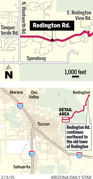
Learn how many of Tucson's streets, roads and highways got their names.
Street Smarts: Highway, mountain named for botanist
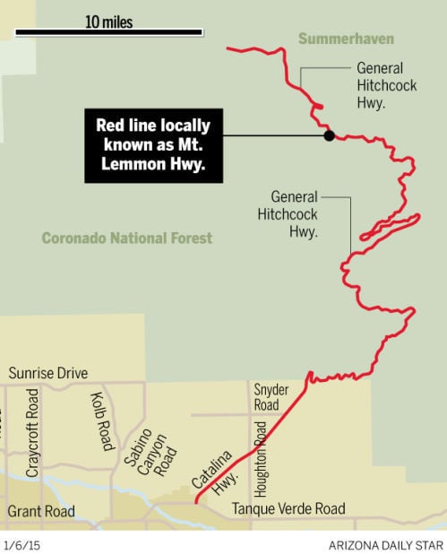
One of several names for the road that climbs Mount Lemmon is the Mount Lemmon Highway.
The mountain itself gets its name from botanist Sara (Plummer) Lemmon. Sara Plummer was born in New Gloucester, Maine, on September 3, 1836 (some sources say 1840). She attended teachers college in Worcester, Massachusetts, and then taught at Grammar School No. 14 in New York City.
After getting pneumonia one winter, her doctor suggested she relocate to a more suitable climate, and she moved to Santa Barbara, California, in 1869.
Plummer opened a small stationery shop, but longed for the intellectual stimulation she had experienced back East. She converted part of her store into a meeting house for artists and the well-educated, and hosted art exhibits and lectures there.
She also procured a couple hundred books from a friend in New York, and later more on a trip to San Francisco, and set up a circulating library. In time, her collection became Santa Barbara’s public library.
Her interest in botany blossomed in California, and she became a founding member of the Santa Barbara Natural History Society (now the Santa Barbara Museum of Natural History) in 1876.
Around this time, she met Union veteran and botanist John Lemmon, who was visiting Santa Barbara. They began writing letters and seeing each other, and he began teaching her botany. When Plummer found an unknown shrub, Lemmon sent it to professor Asa Gray at Harvard University, who then named it Baccharis plummerae (commonly known as Plummer’s baccharis).
The romance led to marriage in November 1880.
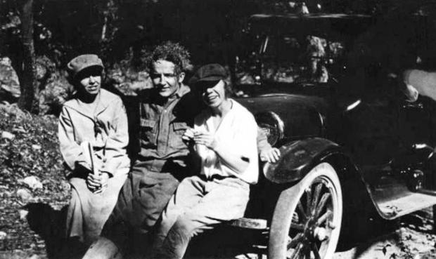
John and Sara Lemmon in the field. Image courtesy of University and Jepson Herbaria, University of California, Berkeley
University and Jepson Herbaria, University of California, Berkeley
Their honeymoon was spent in part studying plants in the Santa Catalina Mountains outside Tucson. On this botanical honeymoon, the couple ascended to the range’s highest peak in 1881. They began the long trek from the town of Oracle and traveled up to Pandora Ranch with the assistance of a donkey. After resting at the ranch, its owner, Emerson O. Stratton, provided them with two horses and guided them up to Carter’s Camp, (now called Summerhaven).
Stratton later wrote, “From Carter’s Camp the Lemmons and I went to the highest peak [9,157 feet above sea level] in the Santa Catalinas and christened it Mount Lemmon, in honor of Mrs. Lemmon, the first white woman up there.”
In 1893, George J. Roskruge solidified the name by adding it to his map of Pima County.
In 1905, the Lemmons returned to Tucson, and the trio once again climbed to the top.
Sara Lemmon was also an important influence in getting the golden poppy adopted as the state flower of California in 1903.
John died in 1908, and Sara in 1923.
Street Smarts: Road honors 'Mr. Rodeo,' county sheriff
Edward F. “Ed” Echols was born to James and Martha (Wingate) Echols on Nov. 7, 1879, in Stockdale, Texas. His father was from Missouri and his mother hailed from Texas, where he grew up and was involved in the cattle business, even helping his father drive cattle up the Chisolm Trail to Abilene, Kansas.
He would later describe it this way: “Of course I was just a slick-eared button of fourteen, and most of the Indians and cross-timber toughs had been run off by the time I went up what was left of the Chisholm Trail, … but even so, with the new railroad meetin’ us more’n halfway, it wasn’t what you’d call no tourist trip ... for Fancy Dans wanting to take a look-see at the landscape.”
In 1902, he left Texas with his brother Art in a Studebaker wagon that had cost them $60. They arrived late that year in Sulphur Springs Valley in Cochise County. His first job in Arizona was hauling wood at $6 a cord. He also hired out as ranch hand at area properties such as the Chiricahua Cattle Co.
Ed Echols and rancher Bud Parker. Echols was Pima County sheriff.
Courtesy of John L. Rhodes
In 1907, he began working in show business, as an exhibition roper with the Miller Brothers 101 Wild West Show at “a princely wage of $15 a week.” But after touring for six months in places like Chicago and New York, he decided to return home. During that time he met the future Western film actor Tom Mix, with whom he would remain friends for many years.
Five years later in 1912, he traveled to Calgary, Alberta, Canada for the first Frontier Days and Cowboy Championship Contest (later known as the Calgary Stampede). He competed in the roping competition against the best in world, riding away with the grand prize of $1,000 and the title of World’s Champion Roper.
In 1921, Echols received a homestead patent for 640.23 acres of land near the small town of Mescal, near Benson. It’s believed that this formed part of Echol’s Double X Ranch, which also included land he had bought in 1917. The ranch was later sold to Tom and Virginia (Ruthrauff) Beaham. Double X Ranch Road near Mescal is named for this ranch.
In 1924, Leighton Kramer, an Easterner who wintered in Tucson and is the namesake for Kramer Avenue, conceived the idea of a rodeo and rodeo parade in Tucson and called upon local ranchers and cowboys to assist him. Ed Echols was one of the men he called upon for guidance.
In 1925, the soft-spoken, 6-foot Texan was again drawn into entertainment, this time touring Europe with the Tex Austin Show.
In 1930, he wed Bennie F. Akers of Spartanburg, South Carolina.
In 1934, he ran for Pima County sheriff and asked another old-time friend, film star Will Rogers, to stump for him. Rogers flew into Arizona and gave an impassioned speech on behalf of his friend at a Democratic Party rally. Echols lost the election — and learned the speech had been mistakenly given in Douglas, which is in Cochise County.
For the next couple years he worked as Pima County cattle inspector. In 1936 he was elected sheriff of Pima County, a role he held for 10 years. It was during this period, on Oct. 12, 1940 — after having visited Tom Mix that morning at the Santa Rita Hotel — that he found himself rushing across the county line toward Florence, to the site where Mix had crashed and died.
Around 1944, Echols and his wife moved to 29 E. Second St., at the corner of Second Street and an unnamed alley.
Following his time as sheriff, he served for many years as a constable in Tucson’s Precinct No. 2., retiring in 1962.
Echols was best known for his role in the Tucson Rodeo and Parade, known collectively as La Fiesta de Los Vaqueros. He was grand marshal of the Tucson Rodeo Parade many times, a title awarded to prominent citizens such as Lute Olson, Gov. Raul Castro and Jim Click. He even gained the nickname “Mr. Rodeo.”
Echols died in 1969.
On May 4, 1951, the Tucson City Council passed Ordinance No. 1247, naming the alley that bordered his house Echols Lane. By 1956 it was changed to Echols Avenue.
Street Smarts: Tucson's Park Avenue named for sports venue
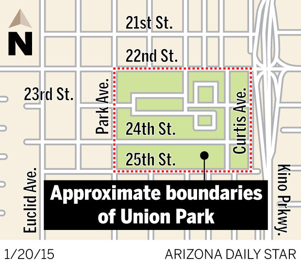
On Sept. 8, 1893, a meeting was held by local businessmen at the Pima County Courthouse, for the purpose of obtaining grounds near or in the city, where sporting events could be held.
A temporary committee was appointed to bring together Tucson’s different sporting groups, such as the gun club, wheelmen club (bicycle club) and the trotting association (horseback riding club) to form a larger athletic club.
1900 map of Tucson shows Union Park and Ed Bullock’s land. Photo by Paul F. LaFrance.
UA Special Collections
Ten days later, a meeting was held at the Tucson City Hall, to review the land options for the new athletic grounds and the committee decided on an offer by restaurant owner Joseph Soldini, whose land was about a mile north of town.
On Sept. 29th, a permanent organization was formed with Judge C.W. Wright, as president. The Board of Directors consisted of Tucsonans from the different clubs, E.N. Fish (trotting association), Dr. George Whomes (bicycle club), Joseph Scott (baseball club) and Charles T. Etchells (gun club). The organization also issued 500 shares of stock at $5 a share to raise funds to build the track, grandstand, baseball field and other items.
The board of directors met on Oct. 16, 1893, and decided on a formal name for the organization, The Union Park Association and two days later the articles of incorporation were filed with Pima County.
The board then decided not to utilize Soldini’s property, because of the caliche found underneath the soil, and instead purchased forty acres of land, about a mile and a half south of the University of Arizona, on the edge of the city limits, for $100 cash and the same amount in stock.
By mid-December, construction of the new half-mile track and a well was underway. Four additional acres were deeded by Ed Bullock to the park for horse training grounds.
In early 1894 a wooden fence, eight and half feet tall and consisting of 3,200 running feet of wood, was built around the park. A roofed grandstand that was 20 feet by 45 feet that could accommodate 250 people was constructed along with a railing inside the park. In the middle of the park was the baseball diamond.
On a windy March 2, 1894, Union Park officially opened. The events for the day included a bicycle race by some of the best wheelmen in the Arizona Territory, a gun shoot with live birds, a horse race between two horses and a practice by a local baseball club to close the day.
Within five months, Union Park was in financial trouble, having a $900 debt. It was announced in the Arizona Weekly Citizen, on August 18th, that the park was under a new board of directors.
The new board appears to have breathed life back into the struggling park, with a successful bicycle racing event on August 31, that featured a half-mile, mile, two-mile, and five-mile races and by enticing “Arizona Charlie” to bring his Wild West show to the park in December of that year. It is believed this was the first time a Wild West show came to Tucson.
The year 1895, saw more write ups about the park in the newspapers, with some of the highlights being an approximately 10-mile race between Albert Schock, long distance champion cyclist of the world and two local horses, with Schock taking the $200 purse in February. In October, surveying started for a new one-third mile bicycle track in the park to be built of a concrete-like material.
But the park continued to be plagued by financial problems, even under the new management.
On March 23, 1895, town councilman James W. Whalley, after an eight-day disappearance, was found dead under the grandstand.
The highlight of an event the following year was a bicycle race in June that attracted cyclist from around the country and also featured trick riding by local rider Seth Orndorff. The attendance wasn’t what management had hoped for.
In 1897 the University of Arizona track & field team held a competition at the venue, which included exhibition bicycle races.
But this was likely one of the last really big events at the park, as the popularity of the track seems to have been on the decline. The Blue Rock Gun Club, a regular at Union Park, found new grounds to hold its events.
Carillo’s Garden, later called Elysian Grove, built a grandstand to go along with its bicycle track, and it appears that some baseball games were being played at the Military Plaza, downtown rather than the Union Park.
The park continued on for several more years but it appears it didn’t have the same prestige as before and fewer events were happening there. The distance from town to Union Park likely played a part in the decline, since other venues offered most of the same sporting events but much closer to town.
In 1902, the Tucson street railway was supposed to be extended to Union Park, offering sports fans easier access, but it appears it was never extended that far south.
It is believed the park survived up until about 1908.
By 1917, the land became known as the Kenrose Park Addition and the land would later be occupied by O’Rielly Chevrolet.
A large apartment complex called The Retreat at Tucson now occupies a large portion of the old track.
While Union Park’s glory days appear to have been short, during its time it was a well-known attraction in Tucson. No known historical markers could be found on the site.
The alignment now known as Park Avenue was originally called “C” Avenue . On June 17, 1897, Park Avenue, which ran from the University of Arizona, south to present-day Broadway Boulevard, was recorded with Pima County, later “C” Avenue was abandoned and the whole alignment became Park Avenue.
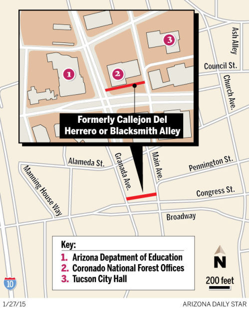
Street smarts: The history of Tucson's 'blacksmith alley'
In 1856, two years after the Gadsden Purchase, Mexican troops left Tucson and were replaced by U.S. soldiers. The same year John Burt, born about 1829 in Vermont, built an adobe structure, a little southwest of the old presidio walls in Tucson and set up a blacksmith shop. It is believed that his place was the first Anglo-owned blacksmith shop in town.
During the Civil War, Tucson became part of the Confederacy but then was retaken by Union forces. Maj. David Fergusson of the California Column was left in charge of Tucson and the surrounding area. Fergusson ordered a surveyor by the name of J.B. Mills Jr. to survey what is believed to be the first map of Tucson, in 1862. All the streets were in Spanish, including Callejon Del Herrero (Blacksmith Alley), which bordered Burt’s blacksmith shop to the north.
The same year, Union forces confiscated property from Frederick Neville that was located just across the alley from Burt’s blacksmith shop, under the claim that he was a Confederate sympathizer. The military blacksmith, farrier and wagon shop was set up there, and Pvt. Thomas Belknap plied his trade there from October 1862 to January 1863. He later returned to Tucson and is likely the namesake of the old Belknap Street downtown.
On Oct. 29, 1864, Burt sold his dwelling house and blacksmith shop to Louis Quesse for $1,500. Quesse was born about 1827 in Prussia and came to the U.S. at 5 years old. In 1845, he enlisted in the U.S. Army in New Orleans for a five-year term. His occupation was listed as blacksmith. He rose to the rank of corporal before being discharged at Taos, New Mexico Territory, in 1850. By 1858, he was residing in Tubac, and the same year married Manuela Otero. In 1861, with no military protection to stop Apache attacks, Quesse’s family and others abandoned Tubac and moved to the farming and mining community of Los Reales, just north of San Xavier Mission. By April 1864, when U.S. Marshall Milton Duffield took the special territorial census, Quesse was a resident of Tucson. Quesse owned the blacksmith shop for a few months short of two years.
On June 1, 1866, Louis and Manuela Quesse sold the house and blacksmith shop to John W. Sweeney for $1,000. Sweeney, a blacksmith, was born in 1836 in St. Louis, Mo. He spent some time in California before arriving in 1859 in Tucson. It may have been that year that he went to work in Burt’s shop.
On May 10, 1863, he wed Manuela Ramirez, the daughter of prominent merchant Teodoro Ramirez. He was the sole owner of the shop until 1869. That year he was a member of the Pima County Supervisors and also formed a partnership with blacksmith Charles T. Etchells. The partnership lasted until 1873 when it was dissolved, and Sweeney sold his interest to Etchells for $3,000, which included Sweeney’s half of the blacksmith tools. Sweeney in time moved to Florence, and Etchells took over the blacksmith shop originally built by John Burt.
Charles T. Etchells, unknown date.
Courtesy Charles T. Etchells
In 1869, Louis Zeckendorf opened a store in the old military blacksmith, farrier and wagon shop, and it appears it was enlarged and absorbed Callejon Del Herrero as it isn’t on the 1872 S.W. Foreman town site survey.
Etchells was born on June 8, 1837, in Michigan. For a few years during the Civil War he worked as a blacksmith for the U.S. Army in Missouri. After being discharged in 1863, he traveled to New York and took a steamer to present-day Panama. Finding cholera and yellow fever common there, he moved on, traveling around Cape Horn, and landing in either in San Francisco or Mexico. By 1864, he was working as a blacksmith at the Heintzelman Mine (Cerro Colorado Mine) southwest of Tucson near present-day Arivaca.
By 1869, he was residing in Tucson and began a partnership with Sweeney. Around this time he met Soledad Borquez and in 1870 their first child Petrawas born, followed by John, Sadie, and Peter. In 1874, he was elected to the Tucson School Board.
In 1873, Etchells was elected to the Tucson Common Council for the first time. He would serve several more times over the years.
During the 1880s, Etchells became the sole agent for Studebaker wagons, which was known as the Ford Model T of its day, because it was a practical, everyday wagon. Competition also increased during this decade, with Adolfo Vasquez and Winnall Daltonopening a shop as well as A.M. Bragg.
Etchells died in 1900.
Callejon Del Herrero either derives its name from John Burt, the first blacksmith on the alley or the blacksmith shop itself that existed from 1856 until about the turn of the century.
Street Smarts: Ranch's history includes hidden outlaws, angry lynch mob
It was 1875 or 1876 when brothers Henry T. and Leonard G. “Len” Redfield rode up the San Pedro Valley into the town of Tres Alamos. With them were Henry’s wife, Malvina and his son, Leonard.
Leonard Darius Redfield, son of Henry T. Redfield, postmaster of Benson. Courtesy of Ethel Amator
Courtesy of Ethel Amator
The family was hungry, so Henry traded his saddle for a sack of corn and rode north for about 9 miles, bareback. They settled there, about a mile or two from the bank of the river, and built a one-room log cabin.
Before long their cattle, bearing the Triangle Dot brand, wandered the valley and foraged on bear grass, juniper and manzanita. The Redfields flourished on cattle and its by-products, with Henry traveling by buckboard to Tombstone to sell butter for $1 a pound. His son carried mail from Tres Alamos to the Redfield ranch.
Within a few years several families lived in the area and, by 1879, a petition was sent to the Post Office Department to establish the Redfield post office. It was rejected and the brothers coined the name Redington (sometimes spelled Reddington) instead. Henry was appointed the first postmaster and the town later took the name from the post office.
By 1880, Frank Carpenter, a nephew of the Redfields’, was living in Redington along with Len Redfield, John Rhodes (later an Arizona Ranger), and Henry, Malvina and Leonard.
During the early years of Redington, outlaws used an area near town as a hideout after a stage coach robbery near Riverside (now Ray, Arizona) that involved the murder of a Wells Fargo employee. Pinal County Sheriff A.J. Doran and his posse followed Joe Tuttle to the Redfield ranch. They arrested Tuttle, as well as Len Redfield and Frank Carpenter, after searching the property and finding a mail sack believed to be from an earlier robbery. While in prison in Florence, Tuttle confessed that he and another man committed the robbery and said Redfield was to get a cut for hiding the money. Redfield denied the accusation.
Henry, believing his brother’s life was in danger, headed to Florence with U.S. Deputy Marshal J.W. Evans of Tucson with plans to move Len to Phoenix to keep him safe. Upon hearing this, a mob overwhelmed the local authorities and lynched Tuttle and Redfield. There was little evidence — if any — of Redfield’s involvement in the crime.
On Oct. 20, 1883, the Arizona Weekly Citizen said Henry Buehman, administrator of Leonard G. Redfield’s estate, had deeded “all the right, title and interest of the said estate, (for) $8,000” to Benjamin and Briggs Goodrich and T.F. Hudson. It also said that Henry T. Redfield had sold 160 acres on the San Pedro River for $5,000 to the same men.
The remaining Redfields relocated to Benson, where Henry started a livery business but died of an overdose of laudanum in 1886. His son served as postmaster of Benson from 1896 to 1940, believed to be the longest term in U.S. history.
Around 1884, rancher William H. Bayless of Bayless and Berkalew Co. moved his operations to the San Pedro Valley. Over the next several years he bought up homesteads, ranches and other land.
Around 1890, as a result of an intense drought, many ranchers had a difficult time surviving, and Bayless and Berkalew Co. bought even more land. The purchases eventually became the 200,000-acre Carlink Ranch. The name of the ranch is derived from the link that connects railroad cars together.
In a sense the Carlink Ranch became Redington, because the school and general store/post office were located on the land and everyone from the surrounding area came there to attend school, shop and pick up their mail.
Chuck Smallhouse, Bayless’ great-grandson, grew up on the Carlink Ranch from the mid-1930s through the late-1940s.
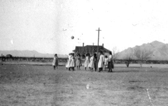
“When I was in the first or second grade, the one-room schoolhouse burned down and was rebuilt with two rooms, although only one was used as the main school room and the other used for storage and the teachings of various arts such as pottery, woodworking and drawing,” he said. “The main room was also used for events such as Christmas parties, student plays and community dances, with music by local musicians. While it was a school, there was no water or electricity. Two pupils took turns carrying water in large pails to the schoolhouse each day, and there were two outhouses. The famous author and teacher Eulalia “Sister” Bourne at one time taught there.”
In 1957, the small community of ranches and farms got electricity.
Redington has remained a small ranching community. The Carlink Ranch, now 60,000 acres, is run by Andrew and Stefanie Smallhouse.
Street Smarts: Tucson Indian School taught hoeing, sewing
Tucson once had an Indian School and a street named after it — but both are gone.
On August 24, 1886, T.C. Kirkwood, superintendent of the Board of Home Missions of the Presbyterian Church, petitioned the Tucson Common Council for a grant or extended lease on 15 acres of land just west of the university to build an industrial school for Native American boys. The council let a 99-year lease at $1 per year for an area of four blocks near the university. The Board of Home Missions then purchased 42 acres on the Santa Cruz River from Sam Hughes for its farms.
While the school was being built in early 1888, Mary Whitaker used a temporary site — the old adobe public school building on Congress Street — to teach about 10 pupils. Later that year, the school’s first permanent superintendent, Rev. Howard Billman, arrived and the school opened with 54 boys and girls.
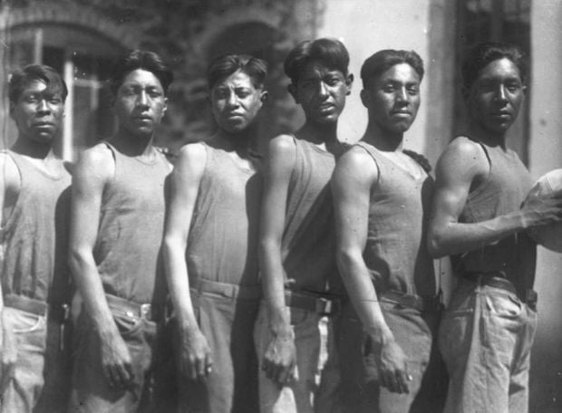
The new boarding school was semireligious. Boys learned trades such as farming, blacksmithing, carpentry and tinning, while girls were taught sewing and similar skills.
In 1890, additional buildings were finished. The stone and adobe work was done by Jules Flin, whose daughter Monica later founded El Charro Restaurant. Even with the additional space, the school soon became inadequate for the demand and students had to be turned away. The following year, Fort Lowell was abandoned and transferred to the U.S. Department of the Interior for use as an Indian school, but it appears it was never used for this purpose.
In 1894, the Tucson Indian School became the last of the schools run by the Presbyterian Church to stop accepting government aid. The same year, boys from the school helped build a small bridge and built chairs for a new Native American church, while the girls sang in a cantata, a religious-themed musical work, at an opera house in town.
By 1895, Rev. Billman had become the second president of the University of Arizona and the Rev. Frazier Herndon became superintendent of the Tucson Indian School. Herndon, who came from Missouri, soon wed one of the teachers, Elise Prugh. Under his direction, the school entered into a contract with the city of Tucson to grade and maintain streets as a way to raise funds. He also expanded the curriculum and brought in more students. One student, Jose Xavier Pablo, who may have been the first Tohono O’odham to graduate from the school in 1903, later became a leader in the tribe.
Around 1903, Rev. Herndon set up the Papago Mission (sometimes listed as an Indian school) around what is now 22nd Street and 10th Avenue. From there, he and his wife carried out missionary work with the Tohono O’odham. In 1904, when George Pusch recorded a subdivision called the Native American Addition just north of that location, he recorded four street names: Papago Street, Sacaton Avenue, Quijotoa Avenue and Herndon Place. The latter was named in honor of the Herndons and still exists. The other three seem to have disappeared in the 1950s.
The school next was under the direction of Rev. Haddington Brown, who along with the Presbyterian Board of Missions on Dec. 31, 1906, purchased the land near the university from the city for $480 and resold it to a developer for a sizeable profit. Then, in 1907, the Board of Missions bought 160 acres just east of the Santa Cruz River and about 4 miles south of downtown for a new school.
On March 25, 1907, the Escuela Post Office was set up on campus, with Rev. Brown as postmaster. The name was chosen after the U.S. Post Office rejected the name Indian School Post Office. Many people came to know the Tucson Indian School as Escuela. The new school opened in the fall of 1908.
In 1912, Pima County made the dirt path in front of the new school a county road, but it doesn’t appear the road was given a name.
The school went through several superintendents until 1915, when Martin L. Girton took the helm for 26 years. By 1920, it appears that the name Indian School Road was in use.
In a pamphlet written by Girton in the mid-1930s said, “The school was originally organized for two tribes: the Pimas and Papagos (Tohono O’odham), but at present the Maricopas and Apaches are also represented....Girls are graded on their ability to darn a stocking just the same as on their ability to ‘do sums’ (and) boys on their ability to handle a hoe as to recite history.” He also wrote that, the “School plant covers 160 acres, 60 acres under irrigation, has 9 buildings, capacity 130 pupils.”
In 1940, about 18 tribes were represented on campus. Around 1950, Indian School Road was made part of Ajo Way.
In 1960, the Tucson Indian Training School at 802 W. Ajo Way — then under its final superintendent, William D. Hennessy — closed its doors. Four years later the Tucson Citizen newspaper announced that the landmark was being razed to make room for a shopping center.
Street Smarts: Miracle Mile's roots include fancy stores, the Mexican revolution
Stanley Williamson led a colorful life, but he’s best remembered for naming Tucson’s Miracle Mile and for developing much of it.
Williamson was born to Peter and Harriet (Hopson) Williamson in Brooklyn, New York on May 18, 1887. When he was 2 his family moved to Rahway, New Jersey, which is where he and his sister Adele grew up.
His first job was at a bank in New York, and then he worked as an accountant for an engineering firm.
Williamson soon developed asthma and was forced to move west. His first stop was San Antonio, Texas, where he and partner Spencer Briggs bought a ranch north of town. For a time they ran a successful business, but a desire for adventure took hold. They sold the ranch and, along with another companion, headed into Mexico.
They set out on horses with the intent of joining an American contingent fighting in the Mexican Revolution. During their time south of the border, they encountered bandits who stole their horses, which were later found. They experienced “times when the bean pot was empty and ... suffered acutely, from lack of water.” They also came across Yaqui Indians who were fighting the Mexican government, which was engaged in a campaign to take their lands and wipe out the tribe.
It’s unknown whether Williamson and his companions actually fought in the Mexican Revolution. They returned to the U.S. after a short time in Mexico, ran out of money in Hope, New Mexico, and found work building a bridge in the area. Later they lived with the Zuni Indians near Gallup, New Mexico, and then spent about three months with the Apaches and Navajos of Northern Arizona.
Eventually they headed to Phoenix and arrived in time to see the 1912 inauguration of George W.P. Hunt, Arizona’s first governor.
In 1914, Williamson wed Laura Swiggett of Phoenix and they had two children, Warren and Jane.
When Pancho Villa started his raids along the border in 1916, Williamson, who was captain of Company C, 1st Arizona Infantry, was called to duty and stayed with his men on the border until the fall of 1917. After spending some time in France during World War I, he returned to the Phoenix in 1919 and moved back to New Jersey in 1922.
In 1927, he came to Tucson and found work at a bank and then at a realty firm. During the 1930s and 1940s, he developed or helped develop subdivisions in midtown Tucson, including the Palomar Addition and the San Clemente Addition, named after the coastal town of San Clemente, California
In 1936, Williamson envisioned a commercial center on the mostly undeveloped Oracle Road, between West Drachman Street and the Casa Grande Highway (now West Miracle Mile). It would be outside of the downtown retail center and similar to the famed Miracle Mile in Los Angeles.
The Los Angeles version was the idea of A. W. Ross, a real estate agent in downtown Los Angeles’ retail district. He guessed correctly that, as downtown got more congested and cars became more common, people would become less dependent on public transportation and more willing to do their shopping by car.
In the early 1920s, he bought land along the south side of Wilshire Boulevard and created a retail district that grew to include some of the poshest department stores of the day. He originally called this strip the Wilshire Boulevard Center, but in 1928 the name was changed to Miracle Mile.
The Miracle Mile went through a period of decline as regional malls took the place of shopping districts, but it has been revived with new attractions like the Peterson Automotive Museum and the Los Angeles County Museum of Art.
Note: Some sources claim that the name for Tucson’s Miracle Mile came from a June 1937 Arizona Highways magazine.
Actually, this part of Oracle Road was supposed to be renamed Parkway Road or Parkway Boulevard after improvements were made to it, but Williamson came up with the name “Miracle Mile” to describe a business center and first used the name in print in a Sept. 11, 1936, ad in the Arizona Daily Star. On Jan. 6, 1937, the Tucson Citizen first used the name “Miracle Mile” to denote the street rather than the business center.
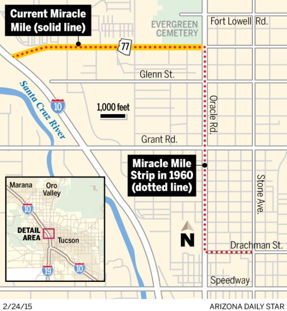
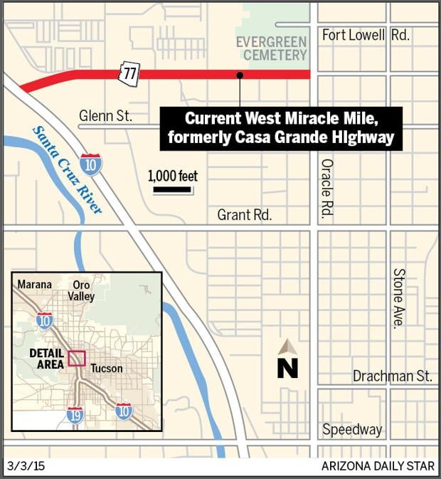
From 1937 to 1960, the street was commonly called Miracle Mile, but officially the businesses had Oracle Road addresses. That changed on Nov. 21, 1960, when the Tucson City Council passed an ordinance changing the name of “West Drachman, from Stone to Oracle Rd.; Oracle Rd., from Drachman to Casa Grande Hwy; and Casa Grande Hwy., from Oracle Rd. to the (I-10) overpass,” to the name Miracle Mile Strip.
Two years later, the City Council had a change of heart and, on May 7, 1962, changed the part of Miracle Mile Strip formerly known as Drachman Street back to its original name. The former Casa Grande Highway, then part of the Miracle Mile Strip, became West Miracle Mile, leaving only present-day Oracle Road with the name “Miracle Mile Strip.”
Miracle Mile Strip remained the official name until Feb. 2, 1987, when the City Council renamed the north-south part of the strip back to Oracle Road. West Miracle Mile is the only one of the original three streets to still bear the name.
Street Smarts: Miracle Mile went to 'Big House'
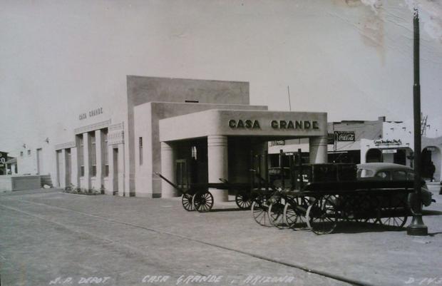
The street known today as West Miracle Mile began its life as the Casa Grande Road because it was the starting point from Tucson for people heading to the town of Casa Grande.
Casa Grande Union High School, photo likely taken in the 1920s.
Courtesy UA Special Collections
The Casa Grande Valley, situated between the Gila and Santa Cruz rivers, was inhabited by Native Americans long before Christopher Columbus arrived in the New World. By 300 A.D., the Hohokam Indians built irrigation canals and planted crops including beans, corn, quash, tobacco and cotton.
Around 1150 A.D., many Hohokam left their settlements for more concentrated river villages. Each consisted of clusters of homes, public structures and public plazas surrounded by walls on all sides. Around 200 years later, what we now call the Casa Grande (Great House or Big House) was built in one of these villages.
The valley eventually passed into the control of the Spanish. During this time Father Kino, a Jesuit priest, became the first known European, in 1694, to see the Casa Grande ruins, at that point long since abandoned.
Courtesy of UA Special Collections: Casa Grande Rail Depot
In 1821, the land became part of Mexico. During the Mexican Period, in the mid-to-late 1820s, a small number of European American trappers such as James O. Pattie traveled in the area hunting the plentiful beavers.
By the 1830s, some small mines were being developed in the area.
In 1854, James Gadsden, the U.S. Ambassador to Mexico, negotiated the purchase of land south of the Gila River, including the Casa Grande Valley from Mexico, making it part of the United States. In 1875, the Casa Grande Valley become part of the new Pinal County, which was formed from parts of Maricopa and Pima counties. Florence was appointed the county seat.
The Southern Pacific Railroad Co. began building a line from California to Yuma and then east, but in May 1879 it stopped construction in the Casa Grande Valley, calling it Terminus, meaning "end-of-the-line." In January 1880, construction of the railroad began again.
Casa Grande. Photo likely taken in the 1920s.
Courtesy UA Special Collections
By September 1880, the town had been renamed Casa Grande in honor of the Hohokam ruins about 20 miles to the northeast. That same year, Jeremiah "Jere" Fryer was appointed the first postmaster of the tiny town. He was probably best known for being the husband of Pauline Cushman, a famous Union spy. At one point they operated the Fryer Hotel in Casa Grande.
Casa Grande would remain a town connected with mining for many years — supplies were dropped off for local mining camps and ore derived from local mines was send elsewhere for smelting.
In 1912, the Casa Grande Times newspaper began publication, likely the first newspaper in town. It later become part of the Casa Grande Dispatch.
The following year the first grammar school opened and in 1914 the town incorporated. The first town election was in 1915 and, the year after that, the first municipal bond election.
In 1917, as a result of that bond election, the first water system was installed and electricity came soon after. Three years later, the Casa Grande Union High school building was completed.
In 1927, Casa Grande saw its first female mayor, Fanne Gaar, in office. The following year, work began on the city sewer system.
In 1929, the Coolidge Dam was completed. While farming in the valley had existed since the time of the Hohokam, the promise of large-scale irrigation drew many new people and the town's population quadrupled from 300 in 1910 to some 1,200 in 1930.
The same year, Casa Grande dedicated new streetlights, sidewalks, the first two miles of paved streets and an airport.
During World War II, from 1942 to 1945, a Japanese-American relocation camp was set up outside of Casa Grande, called the Gila River Relocation Camp. Two notable people interned there were future actor Pat Morita and baseball player Kenichi Zenimura, who built a baseball field and set up a league in the relocation camp.
In 1959, the population of Casa Grande was over 8,000. By 1970, it was the largest city in the Casa Grande Valley, surpassing the county seat of Florence. Farming continued be a large factor in the economy, with cotton being a significant amount of the output.
In the 1990s a few Hollywood movies were filmed on location in Casa Grande: "Three Kings" starring Mark Wahlberg, and "Bodies, Rest & Motion," which was also shot in Tucson and featured local Native American actor Jon Proudstar.
In 2010, the population of Casa Grande had grown to 48,571. In 2012, among the largest employers in the city were the Casa Grande Elementary School District with 1,030 employees, Frito Lay Inc., with 450 workers, and the Casa Grande Valley Newspapers with 150 employees.
Casa Grande Road was officially established by the Pima County Board of Supervisors, on May 5, 1920. It ran from present-day Oracle Road west to the train tracks and north to the Pinal County line following what is now Interstate 10. It was later renamed Casa Grande Highway, and then Miracle Mile.
Street Smarts: Railroad extension made Tucson a 'metropolis'
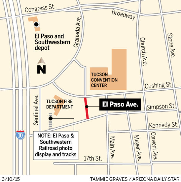
In February 1910, James Douglas, head of the Phelps Dodge Corporation and the namesake of the city of Douglas, announced his plan to make Tucson the western terminal of the El Paso & Southwestern Railroad. Until then, Benson had that honor.
But it seems he spoke too quickly — the board of directors of Phelps Dodge, which owned the railroad, had not yet made a decision. “Knowing this,” the Arizona Daily Star declared, “it behooves the people of this city to get busy and offer them all the inducements possible.”
El Paso & Southwestern freight depot left & passnger depot, back right. Freight depot was converted into a railroad hospital.
Courtesy Pat Stephenson
On Sept. 24, 1910, a committee, appointed by the Tucson Chamber of Commerce, met in Bisbee with Walter Douglas, James Douglas’ son, to pitch the advantages of an extension to the Old Pueblo. Members included Nathaniel E. Plumer of the Southern Arizona Bank & Trust; Hugo J. Donau of Albert Steinfeld & Co.; C.H. Bayless, chairman of the Pima County Board of Supervisors; Fred Ronstadt of Ronstadt Co.; John Mets of the Merchant Bank & Trust; and chamber president George F. Kitt.
On Aug. 1, 1911, news hit town that Tucson would get extension from Fairbank (now a ghost town about 10 miles west of Tombstone) beating out Florence and Phoenix. Whistles blew in celebration. In the streets, people shook hands and congratulated one another.
“Tucson will, in the future, be a railroad center as well as a commercial center and as such is bound to prosper,” prominent businessman Hugo J. Donau, told the Star that day. “This city has always been a good one but will now be a better one and a real metropolis.”
By October 6, 1911 there were 40 camps of railroad workers between Fairbank and the Vail Station, with another one planned within six miles of Tucson.
On Jan. 20, 1912, the Star announced that two different sets of plans for new passenger and freight stations in Tucson were to be submitted to the railroad’s New York office for a final decision. The first design was of classical architecture, with Tuscan columns, and the other was of mission-revival style commonly found in the Southwest. The estimated cost was $40,000 for the passenger station, $30,000 for the freight station and $5,000 for the landscape gardening around both, for a total of $75,000. Construction was to be finished by August 1 of that year.
In March, the railroad chose the classical design, which included a baggage room, ticket office, waiting rooms, operator’s office and a rotunda that was 30 feet in diameter. The roof was to be made of red tile and four Tuscan columns would be by the main entrance.
In April, work on the track began, but progress was slowed due to the inability of a company in Mexico to provide railroad ties because of the Mexican Revolution. On June 22, the Star announced that W.L. Pearson & Co. of Houston and El Paso was awarded the contract to build the passenger and freight stations on Congress Street, as well as the roundhouse and freight warehouse on 25th Street, at a total cost of $125,000.
On Oct. 31, F.L Hunter, manager of the E.P. & S.W. purchasing department, drove in the last spike to complete the rail line, a ceremony witnessed by many Tucsonans. Four days later, a special train with three private cars arrived in town at about 6 p.m., carrying several railroad officials. A car of roofing material arrived that same day for businessman W.A. Julian. These likely were the first “passengers” and freight to arrive on the E.P. & S.W. railroad in Tucson.
The big day came on Nov. 20, 1912, when crowd of about 3,000 gathered around the temporary depot to welcome the first scheduled train just past 11 a.m. Whistles blew, people cheered and the band played “Stars and Stripes Forever,” as the train rolled in. The first speech was by attorney and Tucson Unified School District school board member John B. Wright (namesake of John B. Wright Elementary School), whose short speech was followed by that of former presidential candidate and Arizona Daily Star contributor Eugene W. Chafin.
Afterwards, railroad officials, city officers and delegates of the Tucson Chamber of Commerce had a luncheon at the Old Pueblo Club on Stone Avenue. At the event, Mayor I.E. Huffman read a telegram he said he had just received: “It gives the Pope much pleasure to know that Tucson is connected with the outside world by a third railroad. Thirty-two years ago I called my cabinet together and and we searched in vain for Tucson on the map. Today we all know that Tucson is the best town on earth.” The fictional telegram created much laughter but few of the old timers likely remembered the original 1880 telegram, when the Southern Pacific Railroad arrived.
The passenger depot was completed the following year and served passengers until 1924, when the railroad merged with Southern Pacific. Two years later, the building was to become the headquarters for the U.S. Border Patrol’s Tucson Sector. More recently it was home to two Mexican restaurants, Carlos Murphy’s and Garcia’s.
It’s believed that El Paso Street, now El Paso Avenue, was recorded with Pima County, along with the Ballpark of Southwestern Addition, in 1926.
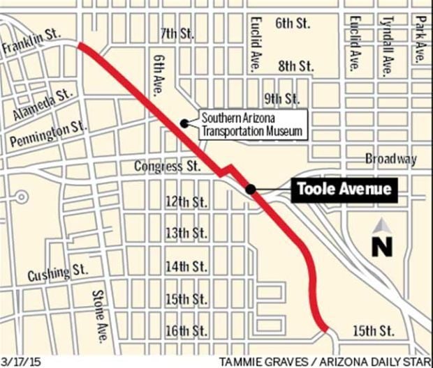
Street Smarts: Toole helped bring railroad to Tucson
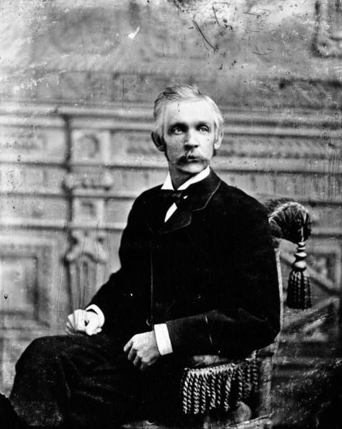
James H. Toole, born in 1824 in New York, began his career in the mercantile business in New Orleans, but traveled to California during the gold rush in 1849.
He was a miner in Placer County until 1861, when he joined the Union Army. He became a 2nd lieutenant in Company G of the California Column, and with his company he came to Tucson in 1862. While here, he served as acting assistant quartermaster and commissary from May 30, 1962, to Jan. 9, 1863, then was promoted to 1st lieutenant and transferred to field and staff as regimental quartermaster on Jan. 10, 1863.
James H. Toole came to Tucson with the Army in 1862 and was first elected mayor in 1873.
Arizona Historical Society, photo B#93,412
He was transferred to Company D on May 19, 1863, in Tucson, and remained here until he was transferred to Las Cruces, Territory of New Mexico, on Nov. 28, 1864. His final stop during the Civil War was El Paso, Texas, where he was discharged on April 5, 1865.
Toole returned to the Arizona Territory and, in 1867, purchased the sutler’s store at Tubac, where he also provided a club room for military officers.
For a few months, in late 1868, he was the adjutant general of the Arizona Territory, in charge of the state militia. The following year he sold his interest in the La Paz silver mine 12 miles west of Tucson.
Two years later, he was listed in the 1870 U.S. Census as a retail merchant, with $2,500 in real estate and $20,000 in his personal estate. That same year, on Oct. 3, 1870, Gov. Anson Peacely-Killen Safford appointed him to the Pima County Board of Supervisors to replace E.N. Fish.
In April, 1872, Toole’s poor health induced him to leave Tucson and return to New York. While on leave, John B. “Pie” Allen (namesake of the Pie Allen Neighborhood) rented his place. He returned in late October with his health restored and, by December, he — along with Gov. Safford, Judge Titus and Dr. J.C. Handy — were looking into mines in Sonora, Mexico.
In January 1873, Toole was elected mayor of the Village of Tucson for a year. That April, he wed Louise M. Dexter, and the couple spent their honeymoon touring Guaymas and other towns in Mexico. They would go on to have five children: James Jr., Robert, Richard, Anna Belle and Catherine.
He was a popular mayor and won 100 of the 101 votes cast in the 1874 re-election. On May 1, 1875, the Arizona Citizen newspaper reported that the by-then former mayor was spending his time conducting research in the “exact sciences.” He was experimenting with ways to get his hens to produce bigger eggs. Toole challenged anyone in Tucson to a competition in producing a larger egg.
On Sept. 23, 1876, the Arizona Citizen declared to a hopeful, but trainless, Tucson: “In three years, the people of this section, and very likely those of Tucson, will daily hear the cheery and energizing sound of the locomotive whistle.”
Toole was once again elected mayor in January 1878. By November, surveyors for the Southern Pacific Railroad were in Tucson, surveying out a route for the train.
L.C. Hughes, editor of the Arizona Daily Star, wrote on May 1, 1879: “The first sound of the locomotive’s whistle will be the notice of a new life for our city and its vicinity, and we look forward to the time when the last spike is driven that connects Tucson with the outside world by a band of iron with a degree of pleasure that we cannot describe.”
Toole, who had been re-elected mayor for a fourth term, and the City Council met with Col. George Gray, chief engineer for the Southern Pacific Railroad, on May 14, 1879. Gray asked for a 100-foot- wide strip of land for tracks to be laid at a northwest to southeast angle across the undeveloped northern part of the village. He also requested a 350-foot wide parcel of land for a freight and passenger depot, as well as a dozen city blocks close by for maintenance facilities, repair shops and roundhouses. All of the railroad’s wishes were granted, free of charge.
Toole and the council called a special election to decide if $10,000 worth of bonds should be issued to defray the cost of obtaining sufficient right-of-way for the railroad. Voters approved the issue and the city government began acquiring the land requested by the railroad.
Toole wrote to Gray: “It affords me pleasure to say that our whole people have heartily cooperated with the corporate authorities in accomplishing the very liberal requirements of your company, and we confidently look for the early completion of your road to Tucson to give a new impetus and prosperity to our city.”
On Aug. 8, 1879, the Arizona Citizen announced that, two days earlier, the City Council had passed Ordinance No. 20, providing for the opening of Toole Avenue.
On March 20, 1880, R.N. Leatherwood, then the mayor of Tucson, greeted the Iron Horse and officials of the Southern Pacific Railroad. Estevan Ochoa — who, along with Pinckney R. Tully, owned one of the most successful freighting businesses in town — was one of many prominent citizens to make speeches. Ochoa presented Charles Crocker, a top official with the railroad, with an engraved silver spike crafted from the first bullion produced by the Tough Nut Mine in Tombstone. Anyone who was anyone in Tucson attended the celebration of the arrival of the train that day.
Toole later became a principal member of the banking firm of Safford, Hudson & Co. (later called Hudson & Co.). When the firm went out of business, the loss took a toll on Toole, both financially and mentally. He lost everything except for his home on the corner of Stone Avenue and Ochoa Street. After sending his wife and children to Beaver Falls, Wisconsin, to stay with her relatives, he boarded a train to join his family. Stepping off the train, onto the platform in Trinidad, Colorado on Oct. 15, 1884, he shot himself and died instantly.
He was buried at Oakwood Cemetery in Beaver Dam, Wisconsin.
Note: It’s believed that Toole’s children went to live with relatives in Iowa, since they appear in the 1885 Iowa State Census.
Street Smarts: Roadway honors lawyer, judge, developer
William H. Sawtelle was not yet 21 years old when he took the exam to become a lawyer. A special provision in the Alabama statutes allowed him to be admitted to the bar.
Sawtelle, born on Aug. 27, 1868 in Tuscumbia, Alabama, had attended the Tuscumbia Classical and Military Academy for three years and then read law — or worked under the tutelage of an experienced lawyer — for more than a year before taking the bar exam. Next, he entered into a partnership with James Jackson, one of the most respected lawyers in the region.
Judge Sawtelle
Courtesy Tom K. Sawtelle
According to his grandson, Tom K. Sawtelle, “One way he earned money while he was reading law was, before train trips, he would buy peanuts and fruit and sell them to passengers on the trip.”
In 1892, he was elected Circuit Solicitor of the Eighth Judicial Circuit for the State of Alabama, comprised of eight counties in the northern section of the state. He was re-elected in 1898, and again to a third term that he did not fill. During part of that time, he was also city attorney for Tuscumbia and served on a local school board.
Also during this time, on June 28, 1894, he married Lulie C. Mhoon in Colbert County, Alabama. They went on to have three children: James, Dorothy and William Jr. Around 1900, the Sawtelle family is believed to have been neighbors with the Keller family, of which Helen Keller was a member.
Sawtelle first visited Tucson in December 1903, and returned to live here permanently in 1904. The reason for the move was his wife’s tuberculosis — but the death of baby Dorothy in 1901 also may have factored into the need for a change of scenery.
Soon after he moved here, he went into private practice as an attorney and became involved in real estate. On May 15, 1907, he filed incorporation papers with Pima County for the Arizona Improvement Company, a development enterprise he began with J. W. Forgeus and other investors.
The company’s first known project was the Fairmount Addition bordered by Campbell Avenue, Third Street, Treat Avenue and Eighth Street. Sawtelle recorded this subdivision along with Forges Avenue (later corrected to Forgeus) and Sawtelle Avenue with Pima County on May 24, 1907.
By 1908 he had an office at 88 N. Stone Ave. and lived at 345 E. Third St. (now University Boulevard).
In 1910, his wife died of pulmonary tuberculosis. The attending physician was Dr. William Vincent Whitmore, the namesake of Whitmore Elementary School.
In 1912, Sawtelle moved his private practice to the Wright building at 46 N. Church St. (now Church Avenue), which he had purchased from Harriet Wright the previous year.
The same year, Sawtelle purchased land, originally owned by Amphitheater School District founder Joseph D. Andrews, bounded approximately by present-day Prince Road, Stone Avenue, Fort Lowell Road and Oracle Road (Tucson-Florence Highway). He also bought other contiguous land.
On Aug. 6, 1913, President Woodrow Wilson nominated Sawtelle as judge in U.S. District Court for the District of Arizona. He was confirmed by the U.S. Senate, took his oath of office, and opened court later that month. He worked out of Phoenix, which at the time was the only city in the state where federal court was held.
Two months later, an Act of Congress provided that federal court would be held in Prescott, Globe, Tucson and Phoenix. For close to 10 years, Judge Sawtelle presided over court in all four locations at various times each year.
On June 5, 1915, Sawtelle married Mary Martin in Pima County. They had one son, Benjamin.
In December 1918, the Tucson Chamber of Commerce chose Sawtelle’s land near Oracle Road to be the landing field for several U.S. Army planes that were mapping out an aerial mail route from San Diego to El Paso, Texas. Fifty men, along with work horses, cleared the underbrush, graded the land, rolled the gravel used for the landing strip and put down long strips of canvas to indicate the bounds of the 500-by-3,000-foot landing strip. Mayor O.C. Parker and a large crowd met the planes at one of the Old Pueblo’s first landing fields.
As the number of cases increased over the years in the District of Arizona, Congress approved the appointment of a second judge. Judge Fred C. Jacobs was the choice and was appointed in September 1922. He took over federal court cases in Prescott and Phoenix, while Judge Sawtelle kept court in Globe and Tucson.
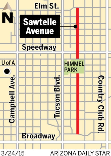
On Oct. 6, 1924, the Pima County Board of Supervisors named a dirt path running from Oracle Road to First Avenue, Sawtelle Road. This was a result of Sawtelle allowing the county to build the road on his land without financial compensation.
In 1925, Sawtelle and his wife subdivided their land near Oracle Road, and recorded the subdivision as Sawtelle Place. They named three streets: Mojave Road, Navajo Road, and Yavapai Road. They also renamed Sawtelle Road to Sawtelle Street. This street is now part of Fort Lowell Road and much of Sawtelle Place is now occupied by Amphitheater High School.
By 1927, Judge Sawtelle had heard more than 1,000 cases.
On Jan. 8, 1931, President Herbert Hoover nominated Sawtelle to the Ninth Circuit of the U.S. Court of Appeals. He served in that capacity until his death in San Francisco on Dec. 17, 1934.
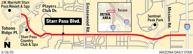
Street Smarts: Starr Pass Blvd. has telegraph-line link
Starr Pass Boulevard, which begins where 22nd Street and Interstate 10 meet and heads west until it ends at the JW Marriott Tucson Starr Pass Resort & Spa, was named after a toll road built in 1884 that ran nearby.
The road’s namesake was born Richard Pollock on Sept. 3, 1844, in the state of New York, the second child of Sebastian and Melinda Pollock. His father, a merchant from Europe, died in 1847 in New York, and it’s believed that Richard’s grandfather, S. Leopold Pollock, helped raise him until his mother married Thomas N. Starr in 1851 and the children adopted the Starr name.
The family sailed around Cape Horn at the bottom of South America and arrived in San Francisco, where Starr was the proprietor of a hotel. The couple would have five more children, but one would die in infancy.
Richard Starr lived in San Francisco for many years and worked as telegrapher. He was also involved in the failed Alaska-Siberia Telegraph (aka Collins’ Overland Telegraph) project in the mid-1860s.
In 1868, he was a bookkeeper in San Francisco, and two years later he was working as a telegraph operator in Humboldt County, Nevada. Around 1877, in California, he married a New Yorker named Henrietta (commonly called Hettie), and they had their first child, Seely T. Starr, on Dec. 2, 1877.
Starr Pass on the Official Map of Pima County in 1893. Courtesy of the U of A Special Collections
UA Special Collections
In 1880, Starr arrived in Tucson from Yountville, California, where he had worked as a telegrapher for the Southern Pacific Railroad. By the following year he was working at the Western Union Telegraph Office as a clerk and operator.
In 1882, he was working as a real estate agent, and that summer he sold Pima County Sheriff Bob Paul an adobe house at 146 E. Pennington St. for $2,900. The lawman and his wife lived in that house for 20 years.
A Jan. 15, 1884, Arizona Daily Star article described the beginnings of the original Starr Pass road: “The stockholders of the Arizona Telegraph Company, organized for the purpose of building a telegraph line from this city to the Quijotoa bonanzas (mines) ... yesterday met and elected officers and let the contract for the construction of the line.
“The contract for building and equipping the line, complete and ready for operation, was let to J.A. Browder and Richard Starr at $210 a mile. These gentleman will begin work at once, and say that they will have it in operation within sixty days if nothing happens. Mr. Starr, accompanied by Mr. Richards, civil engineer, and Samuel Hughes, C.R. Drake and Thomas Driscoll, will leave this morning to select the most practicable route.”
Three days later, Starr recorded with the Pima County Recorder’s Office a certificate and plat map in which he named the future Starr Pass “Quijotoa Toll Road.”
On April 3, 1884, the Star announced that the first telegraph from Quijotoa to Tucson had been accomplished the day before: “Quijotoa, April 2 —The Forces of nature allow the bonanza camp to salute Tucson by wire for the first time and convey to the Star the cheerful intelligence that the prospects are of the very brightest.”
It’s likely the toll road and telegraph line didn’t see much use after the boom at the Quijotoa mining district ended about 1885. Mining in that area died off around 1894.
On May 3, 1884, Richard and Hettie’s second child, Richard R. Starr Jr., was born, followed five years later by Eugene Grant Starr on Feb. 22, 1889.
In the 1897 Tucson City Directory, Starr is listed as an auctioneer living at 134 W. Pennington St. It’s likely he was still involved in real estate, because that was the profession listed the following year, with an office at 73 W. Congress St.
In 1901, the Starr family moved down the street to 194 W. Pennington and moved again the following year to 192 Court St.
On March 10, 1904, in partnership with L.W. Wakefield (likely former Pima County Sheriff Lyman W. Wakefield), Starr bought 80 acres of land for $10,000 from Ellen Lonergan. On it he built the South Park Addition, bounded by East 22nd Street to the north, East 25th Street to the south, South First Avenue (railroad tracks) to the east and South Sixth Avenue to the west. The name of the addition likely came from the city park now known as Santa Rita Park, then called South Park.
By 1906, the family was living in the South Park Addition, at the corner of 22nd Street and Second Avenue.
Richard Starr died on Feb. 28, 1916, after a long fight with chronic bronchitis. He is buried at Evergreen Cemetery.
The original Starr Pass (Quijotoa Toll Road) still exists today, known as the Starr Pass Trail.
Starr Pass Boulevard was originally part of 22nd Street, but the Tucson City Council changed its name on Aug. 2, 1993.
Note: Eugene Grant Starr, Richard Starr’s son, is the namesake of the National Audubon Society’s Starr Ranch Sanctuary in Orange County, California.
Street Smarts: First fence built to hold back cattle
Nogales Highway derives its name from the border town that’s about an hour’s drive south of Tucson.
Nogales, Arizona, whose name means “walnut trees” in Spanish, is said to have taken its name from the plentiful trees in the surrounding hills. It was previously known as Isaacson and the Line City.
Here’s a snapshot of what the town was like in 1897:
• It was the second city of Pima County, both in size and in importance. Two years later, it became the county seat of the newly formed Santa Cruz County.
• The mayor was G.A. Avery, a pioneer merchant in the furniture business who served about three years on the Nogales City Council and four years on the Pima County Board of Supervisors.
• The population was roughly 2,000 people in Nogales, Arizona, and about the same in Nogales, Sonora.
• People traveled from Tucson to Nogales by rail or stagecoach. The Southern Pacific Railroad carried passengers to Nogales, where P.J. Zeimet, whose office was on the border line, was the railroad agent. Travelers who wanted to see some of Arizona’s backcountry. including the valleys, mountains and the Santa Cruz River, could book a slower trip on Mariano G. Samaniego’s stage line.
• The Erie Cattle Co. built 75 miles of fence that year east of Nogales along the border. The purpose was to keep their cattle from wandering into Mexico, but this was likely the first large-scale fencing of the 389 miles of the Arizona-Sonora border. In the town itself, Sonora Gov. Jose M. Maytorena ordered construction of an 11-wire fence in 1915 — but it was taken down four months later. In 1918, as a result of the Battle of Ambos Nogales, both the U.S. and Mexico agreed on a permanent fence down the middle of International Street.
• The police force consisted of the city marshal and one assistant. The city marshal and his counterpart in Nogales, Sonora, appear to have had a private understanding about individuals crossing the border to seek immunity from arrest. They were quickly pushed across the line in the sand and into the hands of the law on the other side.
• The town had a volunteer Fire Department and boasted a high-pressure fire engine that had cost $1,500.
• About 20 new and modern buildings had been built in Nogales, Arizona, and there was talk of building a fine new City Hall, fire engine house and opera house. The town already had a telephone system, electric lights and water works, as well as an ice plant, although it is unknown how many residents had these services in their homes and businesses. The main fuel used in town was wood, and a “sewerage” system was being considered.
• The title to property was uncertain because some people claimed that the town fell within the limits of the Los Nogales de Elias land grant, which they had claim to. However, the U.S. Supreme Court decided in 1896 that the townsite was outside the boundaries of the land grant and it was expected that title to property would be given out in the next few years. This was expected to help the growth of Nogales.
• Business was done in cash, with credit used only in rare cases. It’s believed that Mexican currency was still commonly used in Nogales, Arizona, at this time.
• The town had three churches. The Methodist Episcopal Church, led by the Rev. S.V. Dilley, had a congregation of about 40 people and a seminary school with 180 pupils. It also had a Spanish branch, run by the Rev. E. Quinones, which held services in a separate building. The second, Trinity Congregational Church, had been established in 1887 and was run by the Rev. J.H. Heald with an average attendance of 35 parishioners. The third was a Catholic church, which was well-attended in spite of having another one of the same denomination just across the border.
• Public school was held in a large building and was run by professor T.F. Grindell, along with two teachers: Ms. Ekey and Ms. Sprecher. The school district had 432 children, but not all of them could attend classes due to a lack of accommodations.
• Two newspapers helped keep residents up to date with local happenings. The Oasis was founded by Allen T. Bird in the boomtown of Arizola, Arizona, and moved for a short time to Benson before relocating to Nogales. The Border Vidette originated in Nogales in 1894, published by Frank M. King.
Street Smarts: Typo leaves man with misspelled legacy
William J. Osborn, who held several key posts in early Tucson, was born in New York on Feb. 6, 1834.
It’s been said that he served as a messenger boy for William L. Marcy, who was President Franklin Pierce’s secretary of state and who was involved in the Gadsden Purchase, through which the U.S. bought present-day Southern Arizona from Mexico.
Osborn eventually moved to Leavenworth, Kansas Territory, where he and William H. Adams established the Kansas Weekly Herald in 1854. The newspaper was the first in the territory, but Osborn severed ties with it after about a month. The following year, he was appointed U.S. postmaster at Wyandott, Kansas Territory, and at one point was elected to the Kansas Territorial Legislature.
He joined Albert Sidney Johnston’s Utah Expedition as chief of citizen transportation and later served in the Utah Territorial Legislature from 1858 to 1859. In 1860, Osborn was living in Carson City, Utah Territory, and worked as a Pony Express rider. The following year, the Nevada Territory was cut from the Utah Territory and before long he was elected to the first Nevada Territorial Legislature.
During the Civil War, Osborn was appointed to take charge of a wagon train headed to California. After traveling to numerous points in the state, he was sent to Wilmington, near Los Angeles, to await orders. The wagon train was then loaded with supplies for the Union Army and was ordered to Tucson, where it arrived in 1863. He left the Quartermaster Service when he arrived here.
The 1864 Arizona Territory Census shows Osborn living in Tucson and working as a trader. Later in the year, on July 18, 1864, he was appointed by Gov. Goodwin as judge of the first territorial election here.
He relocated to Tubac, where he worked as a farmer and was elected to the Third Arizona Territorial Legislature, which convened in Prescott on Oct. 3, 1866.
At the territorial session, Gov. Richard C. McCormick (the namesake of McCormick Street) delivered a message about the condition of the territory, which included the lack of internal public transportation: “I am ashamed to say that to this day there is not a stage coach running in Arizona, although the territory has been organized nearly three years. Lines from Wilmington (now part of Los Angeles) and San Diego to Fort Yuma, and from San Bernardino to Hardyville (now Bullhead City) have lately been established. Connecting lines to Tucson, La Paz, Prescott and the Rio Grande should be provided by some of our enterprising citizens without delay. ... Until well-conducted lines of coaches are established, we cannot look for a great increase of population, however tempting our mineral wealth.”
In 1870, Osborn was living at Camp Crittenden and partnered with Frenchman A. Lazard as traders on a military post. Lazard bought out Osborn and dissolved the partnership in 1870. Osborn moved back to Tubac, but relocated to Tucson by the year’s end because of Indian attacks.
In 1871, when the village of Tucson was incorporated, Osborn became the first village recorder, a role he filled for the next three years. He was appointed probate judge for Pima County and also assumed the duties of ex-officio superintendent of schools in 1874 and 1875. From 1883 to 1884, he served as clerk of the Pima County Board of Supervisors.
Osborn created one of Tucson’s first subdivisions when he purchased land from John Moore at present-day 22nd Street on Dec. 22, 1877. The parcel, known as Osborn’s Addition, included three blocks between current 22nd Street and 25th Street, with 150-by-80-foot lots that sold for $30 to $75 each. A trolley was projected to run past the addition.
In 1880, when Philip Contzen (namesake of Contzen Avenue) surveyed Tucson, he listed the road running from Simpson Street, southwest through what is now Carrillo School down to the city limits, as Osborn Avenue.
Osborn lived in the addition that bore his name, which was south of the Tucson city limits. A March 15, 1884, Arizona Citizen article described the road as “the main thoroughfare for all travel leading southerly and westerly from the city” and called it “the finest drive leaving the city.”
In 1903, John Mets recorded Osborn’s Addition and Osborn Avenue with Pima County. Mets may have owned the land at this point or he may have recorded it on behalf of Osborn. This is believed to be the first official filing of the subdivision with Pima County. In 1906, when J.B. Wright drew the Map of the City of Tucson and Additions, he listed the road as Osborn Avenue.
At some point after 1906, the alignment of the road changed at 22nd Street, to more of a straight southerly direction. This may have been the result of the El Paso & Southwestern Railroad buying part of the Osborn’s Addition and building its roundhouse there.
Beyond his work life, Osborn had a family in Tucson. He wed Anna Johnson, a schoolteacher from Sweden, on Dec. 4, 1873, in a ceremony performed by Gov. Anson P.K. Safford. They had two children: Mary C. and Willie.
Will died of diphtheria in 1886. On June 29, 1896, Mary — just back from Cornell University — married professor George L. Hoxie, who is believed to have taught physics and mechanics at the University of Arizona. They left the next day to return to Cornell and went on to have four children: Dorothy, Robert, Stephen and Henry. Osborn died in 1908 at age 73. He was buried in the A.O.U.W. (Workmen’s) section of the Court Street Cemetery. In 1915, his remains were reinterred at the Evergreen Cemetery. His wife died in 1919.
By 1929, with no family members living in Tucson, Osborn Avenue was being spelled incorrectly as Osborne Avenue, as it is today. William Osborn’s tombstone at Evergreen Cemetery, which appears to be relatively new, also incorrectly lists him as W.J. Osborne.
Street Smarts: Few Tucsonans saw Wyatt Earp as hero
Earp Boulevard honors Arizona’s most famous lawman.
Wyatt Earp was born to Nicholas and Virginia Earp in 1848 in Monmouth, Illinois. Soon after, the family moved to Iowa and then in 1864 to San Bernardino, California. From 1866 to 1868, Earp explored the West while hauling freight from Wilmington, California, to Prescott, making stops in Las Vegas and Salt Lake City.
Frank Stilwell was killed by Wyatt Earp and Doc Holliday at the Tucson train station. Courtesy of Wikimedia Commons
Wikimedia Commons
In 1869 he rejoined his family, by then living in Lamar, Missouri. In 1870, he married Urilla Sutherland and the next month he got his first law-enforcement job as constable of Lamar. His wife died that year of typhoid fever.
In 1876, he moved to Dodge City, Kansas, and eventually became city marshal. There, he met Bat Masterson and Doc Holliday. It’s likely he also met Mattie Blaylock, a former prostitute, here and would remain with her until 1882.
Earp and Blaylock arrived in the mining town of Tombstone in December 1879 and were joined by Earp’s brothers Warren, James, Morgan and Virgil. Virgil was named town marshal. Wyatt, who normally worked at the gambling tables of the Oriental Saloon, at times served as his deputy.
On Oct. 26, 1881, a growing feud between the Earp brothers and the Clantons and McLaurys, who had ties to an outlaw gang known as the Cowboys, exploded into what became known as the Gunfight at the O.K. Corral. The short gunfight posed Wyatt, Virgil and Morgan Earp, along with friend Doc Holliday, against Tom and Frank McLaury and Billy and Ike Clanton. After the smoke had cleared, the McLaury brothers and Billy Clanton were dead.
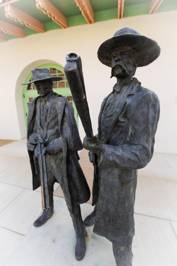
In the aftermath of the shootout, on March 18, 1882, Morgan Earp was murdered in Tombstone. Two days later, Wyatt, his brother Warren, Doc, and a few other men escorted the injured Virgil and his wife, Allie, to the Tucson train station, where they were to depart for California. While at the station, Wyatt and his posse became aware that Frank Stilwell, who was believed to be one of Morgan’s killers, was lurking around.
Wyatt Earp and Doc Holliday statue at the train station downtown. Commemorates the revenge killing of Frank Stilwell there. Photo by Paul F. LaFrance
Wyatt spotted Stilwell, and the group chased him along the tracks. This was soon followed by shotgun and pistol blasts and ended with Stilwell’s death. George Hand, a Tucson saloonkeeper and diarist, wrote in his diary after seeing the body the next day that Stilwell was: “the worst shot-up man that I ever saw.”
(A sculpture of Wyatt Earp and Doc Holliday near the historic train depot downtown commemorates the shootout.)
After the Stilwell killing, Wyatt, now a fugitive for the murder, left Arizona and eventually ended up in San Francisco. There, he became involved romantically with a former acquaintance from Tombstone, actress Josephine Marcus, who at one time in Tombstone had been the girlfriend of pro-Clanton Cochise County Sheriff Johnny Behan (namesake of Behan Street). Beginning in 1883, they became inseparable and traveled on mining and gambling trips to Idaho, Colorado, Arizona, California and Alaska.
In the very early 1900s, Earp ran a saloon in Tonopah, Nevada, and in 1906, the couple moved to Los Angeles, where he befriended celebrities such as Tom Mix and William S. Hart.
In 1927, Earp returned to Tucson, likely for the last time. He had lunch at the Old Pueblo Club on South Stone Avenue with former U.S. Marshal William Breakenridge, Manny Drachman and Manny’s son, Roy Drachman.
Roy Drachman would later write: “I don’t remember telling anyone about having lunch with Wyatt Earp until many years later, when he began to be looked upon as some kind of hero. That was not his image around Arizona, where many people knew and remembered him. I never heard anything from those folks about any of the good or great deeds that he is supposed to have done. He was a tough survivor when some of his close friends and relatives weren’t so lucky in avoiding a violent death.”
He lived in Los Angeles until his death in 1929.
The south-side Los Ranchitos subdivision, along with Earp Boulevard, was recorded with Pima County in 1941.
Street Smarts: Country Club, Golf Links used to be one road
On Jan. 25, 1904, attorney Frank H. Hereford, W.H. Barnes and L.H. Manning filed the paperwork to form Tucson’s first country club.
The original Tucson Country Club was on the northwest corner of Campbell Street (now Campbell Avenue) and Feldman Street (now Speedway Boulevard), on land deeded for this purpose by Nathaniel Plumer and Fred Steward.
Hugo Donau. Courtesy of Tina Lyons
Courtesy of Tina Lyons
“A country club is not a new idea, as it has been the aim and ambition of the people of Tucson for a number of years,” the Arizona Daily Star announced two days later. “The preliminary steps have been taken, the corporation organized, ground secured, the extension of the street railway, city water and electric lights to the ground arranged for, and the club is an assured success.”
On Feb. 1, 1904, the Arizona Republican reported that “Architect Brown is now preparing plans for the club-house, stables etc. ...The club house will cost four to five thousand dollars and will contain (a) large reception hall, dining rooms, bath rooms, dressing rooms etc. On the grounds will be found golf links (a nine-hole one), tennis, basket and handball courts, children’s play grounds, etc. There will be sheds for horses, carriages, automobiles and bicycles.”
The golf course was completed the following year, and Tucson Country Club opened for business. During the next few years, it appears the country club struggled. In May 1907, it offered to sell a portion of its property to pay off debts, but soon after managed to raise the money and got on sound financial footing.
A portion of a map from a Nov. 22, 1936, Arizona Daily Star article, showing the Tucson Golf & Country Club. Courtesy of the Arizona Daily Star
By 1909, there was talk of building a new country club farther east on Speedway Boulevard, because the current clubhouse and golf links were too small. That year, John M. Roberts, owner of the California Wine Co., in Tucson, acquired a 160-acre homestead along Broadway Boulevard with the intention of using the land for the new country club. That never happened, and instead he subdivided the land and named the streets in honor of his favorite authors and poets.
By April 1911, Tucson Country Club was fading away. Capitalist Wait Talcott and Hugo J. Donau, vice president of Albert Steinfeld & Co., hatched a plan that membership would be limited to the finest business and professional men of the town and that Tucson would become a winter golf center.
The men hired William Watson, a golf expert from Los Angeles, to find a suitable location for the new country club and golf course. Potential sites included the Garstang Ranch northeast of the city, a site near St. Mary’s Hospital, and several sites along Speedway Boulevard.
On Feb. 4, 1914, the Tucson Golf & Country Club (commonly called the Tucson Country Club) was incorporated. On Feb. 17, the board of directors chose 120 acres of the Hereford Ranch, a few miles east of the city along Broadway, as the new site. The following day, the land was surveyed under the direction of Jack Adams of Douglas, and plans were laid out for the dirt, or “skinned,” 18-hole course. By August, all 18 holes were completed, and on Dec. 19, the clubhouse opened. It cost $15,000 to $20,000 and had hardwood floors and chandeliers. A pool and tennis courts were later added nearby.
The 1915 members’ list of the Tucson Golf & Country Club reads like a Who’s Who of Tucson. Members included Judge William H. Sawtelle (namesake of Sawtelle Avenue), pioneer Sam Hughes (namesake of the Sam Hughes Neighborhood) and accountant James M. Lawton (namesake of Camp Lawton, the Boy Scout camp on Mount Lemmon).
From 1915 to 1919, the club was a popular destination for local golfers and winter visitors.
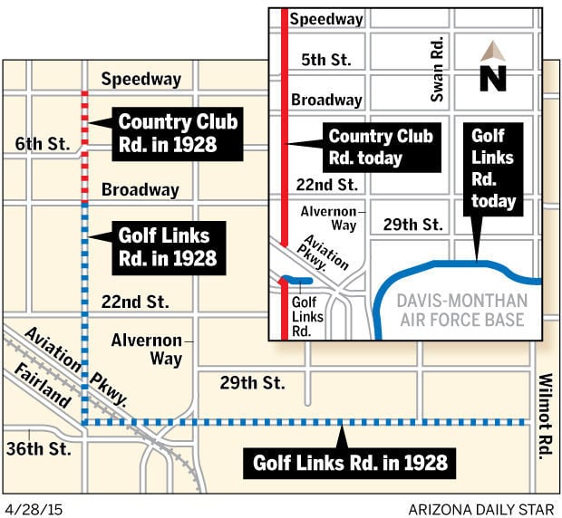
In December 1919, country club members including David W. Bloom and Gordon H. Sawyer petitioned the Pima County Board of Supervisors to turn a mile-long dirt road running from Speedway to Broadway into a county road. The supervisors approved Road No. 4 on April 5, 1920, and later that month the name was changed to Country Club Road.
In 1922, members including Monte Mansfield and H.S. Corbett petitioned Pima County to make a county road out of a dirt road, six miles in length, in the shape of an L, running south from Broadway then heading east through what is now Davis-Monthan Air Force Base to Wilmot Road. The supervisors approved Road No. 57 on Nov. 6, and within six years it became known as Golf Links Road. The north-south portion later became part of Country Club Road, and the east-west alignment was changed so the road no longer ran through the base, but north of it.
In the early 1920s, the Tucson Municipal Golf Course was built nearby at Randolph Park, but it was a dirt course and posed little threat to the Tucson Golf & Country Club. In 1929, El Rio Golf Course opened on the west side of town as Tucson’s the first grass course. Many members left for the new green course. By 1932, the Tucson Golf & Country Club had a campaign underway to change its dirt course into a grass one,.0 but it appears the going was tough and things continued to decline.
In 1936, likely for only a short while, the Tucson Golf & Country Club was leased by Ed Lee and renamed Lee’s Amusement Palace, a gambling hall. By the following year it was in foreclosure.
In 1939, developer John W. Murphey bought a strip of land on Country Club Road south of Broadway and developed the Broadway Village subdivision as well as the Broadway Village Shopping Center. By 1944, most of the golf course land was owned by Broadmoor Realty Co., which developed it into the Broadmoor Subdivision.
The last organization to occupy the clubhouse was the Tucson Shrine Club from about 1945 to 1968; not longer after that it was razed.
Note: The current Tucson Country Club north of Tanque Verde Road was built in the late 1940s and is the third country club to bear the name.
Street Smarts: Tucson's biggest manufacturing plant was almost built in Phoenix
Denver, Colorado, architect Axel Johnson tried twice to make a construction business fly, starting with the day in 1947 when he walked into Roy Drachman’s downtown Tucson real estate office, looking to rent office space to set up a construction company.
And he failed twice, due to lack of financing.
But he wasn’t ready to give up on making Tucson his home. He told Drachman, with whom he had become close friends, that he would get a large company to establish a plant here and become its manager.
Howard Hughes speaking at the Press Club in Washington D.C. in 1938. Courtesy of the Library of Congress
Courtesy of the Library of Congress
Before long, Johnson was offered a job as head of construction for Hughes Co., in Los Angeles. Part of his job was to design a large plant in a still-unchosen city several hundred miles from the Pacific Coast.
The impetus for a new electronics/missile plant was Howard Hughes’ long-held fear that his plant in Culver City, California, was vulnerable to enemy attack because it was on the Pacific Coast. This anxiety was in part due to the Korean War, which began June 25, 1950.
Johnson worked secretly, with Drachman and the Tucson Chamber of Commerce, to have brochures and other literature expounding the benefits of relocating to the Old Pueblo sent to decision-makers in Hughes Co.
On Jan. 12, 1951, Drachman began a 10-day tour between Phoenix and Tucson, with executives of the Hughes Co., to locate land for a new plant. Several cities were being considered.
The executives were suspicious that people wanted to know what they were up to. When meetings were held in Tucson, they were held at night, usually at a hangar at the airport or at the home of the Tucson Airport Authority Chairman Monte Mansfield in El Encanto Estates.
Hughes Aircraft plant under construction south of Tucson in June, 1951. Photo taken facing northwest. Building in the center is now known as Building 801. Graded area south of the train tracks is about the location of Hermans Road. It is now Raytheon Missile Systems. Star photo
At some point early on in the negotiations, Tucson Mayor Joe Niemann, Pima County Board of Supervisors Chairman J. Homer Boyd and Chamber of Commerce Secretary Ed Goyette were brought up to speed and sworn to secrecy.
When word got out that Hughes Co. representatives were leaning toward a 1,800-acre area in Phoenix as the plant site, land prices in that area shot up by $600 to $1,000 an acre within four days. This sudden increase in prices helped convince the already-nervous company negotiators that Drachman’s bias toward the Old Pueblo was justified.
It was decided that the Tucson Airport Authority would sell 2,560 acres at $50 an acre — for a total of $128,000 — to the Hughes Co. (The amount was later reduced to 2,431 acres at a cost of $121,550).
The money would, in turn, be spent by the TAA to help build a paved taxi strip from the airport to the plant site, construct a 1.5-mile railroad spur from the Southern Pacific Railroad (Nogales line) to the plant, and build a waterline from airport wells to the plant’s property line.
After Drachman obtained options on 32,000 acres of raw land around Tucson, in addition to the purchase of land south of the airport, the company felt it was time to announce its intention to build a plant in Tucson.
On Feb. 2, 1951, the Arizona Daily Star announced that “Howard Hughes will build a multimillion-dollar defense plant — manufacturing guided missiles — in Tucson. …The Del E. Webb Construction Co. … has been given the contract.”
By dusk that same day, bulldozers had cleared a road from Nogales Highway to the job site, materials for the plant had been unloaded and ground had been broken on the largest industrial development in Tucson’s history, on land south of the municipal airport.
By Feb. 21, 1951, the company had set up a temporary office on the second floor of the terminal building at the municipal airport.
The first Hughes Co. operation in Tucson began on July 16, 1951, when a small number of trainees began receiving paid instruction in the assembly and testing of electronics at the company school, in a renovated warehouse on the west side of the airport.
During the summer of 1951, as sections of the massive plant were completed, the Hughes Co. began using them for training, as well as for manufacturing. The first electronic components produced at the still-unfinished plant were radar nose assemblies for the Northrop Corp.’s F-89 Scorpion fighter.
On Aug. 25, 1951, members of the Tucson Kiwanis Club toured the building, which was still under construction. An auto caravan drove them through the large doors and across the concrete floor, where they watched workers build the walls.
South of the plant, workers were setting up power and telephone poles. A 12-inch sewer line had already been connected to the city disposal system on South Sixth Avenue.
On Sept. 10, the commanding general of the U.S. Air Force ordered the plant to be purchased by the Air Force. On Sept. 28, 1951, the Hughes Tool Co., the parent company of Hughes Aircraft, agreed to the sale.
The purchase was part of the federal government’s policy at the time of owning newly built defense plants while allowing private enterprises to run them.
The new security chief of the Hughes plant, Mr. Weld, spoke about the potential vulnerability of the new site on Oct. 27, 1951: “With plant construction entering its final stages, there’s no room for prying eyes and unauthorized visitors. … Espionage isn’t a fictional device; it’s an actual menace, even here in Tucson. … There are about 158 active Communists in Arizona, and their danger exists in their espionage systems, not their political ideology.”
In mid-December, Roy Drachman wrote in his company’s newsletter, the Realty Digest, that the Hughes plant had been completed and was in operation, but Hughes officials were unwilling to confirm the status of the plant.
On Dec. 31, 1951, the title to the Tucson plant and approximately four sections of land in its immediate area were deeded to the Air Force.
Hughes Access Road was completed and opened in 1956.
Note: The Hughes plant is now Raytheon Missile Systems.
Street Smarts: Early pioneer built brewery, battled bandits
You might assume a key midtown street was named for Christopher Columbus. Actually, Columbus Boulevard honors Columbus A. Glasmann (sometimes written as Glassman), a man of many trades in early Tucson.
Glasmann was born to William and Christiana (Kramer) Glasmann, both of Germany, on August 20, 1855, in Davenport, Iowa. His father was a merchant of some wealth, and his brother William Jr. went on to a colorful career raising buffalo on the shores of the Great Salt Lake. William also served as mayor of Ogden, Utah, and was editor of The Ogden Standard newspaper.
In December 1875, Columbus Glasmann left the Midwest on horseback, heading for South America. About six months later he rode into Tucson for a visit with his uncle, Heinrich “Henry” Glasmann, who persuaded him to stay.
Henry Glasmann had come to Tucson as a private in the Union Army during the Civil War. He spent time in Tubac and became wealthy, but was forced out in 1870 by constant Apache attacks. The following year, he ran a butcher shop in the Doss Building in Tucson but by late 1873 he was living in Florence. In 1876, he revived the mostly or fully deserted Tubac by opening a hotel there.
Many years later, Columbus Glasmann described what Tucson was like when he arrived: “The main part of the town was on two blocks on Main Street — one north and the other south of Congress (Street) ... Ox teams and mule teams creaked along the streets … There were no banks, for everybody kept his money in his pocket.”
Around 1883, Glasmann was hired by Alex Levin as manager of the Park Brewery at Levins Park. On Jan. 12, 1884, the Arizona Weekly Citizen announced that Glasmann and Louis Enricht had purchased Snyder’s brewery from the mining town of Total Wreck and were shipping it to the boom town of Quijotoa, where they were putting up a brewery along with a dance and variety hall. On April 12 of that year, the paper announced that, “Glassman & Co.’s brewery began brewing last Saturday.”
It’s believed that Glasmann worked as a brewer or saloon keeper for many years and then got involved in ranching in Pinal County. By the beginning of the Mexican Revolution in 1910, he had extensive cattle interests on the border but lost much of his stock to repeated raids by bandits.
In July, 1911, when Glasmann heard about the murder of rancher John Bouschet, he offered a $1,000 reward on top of a $500 reward offered by the Pima County Board of Supervisors to assist in the capture of the killers. It’s unknown if the perpetrators were ever captured.
Glasmann became associated with the Pace Hay & Grain Co. in 1913 and worked there until at least 1914.
On April 25, 1914, the Arizona Daily Star announced that he had bought the Worley ranch on Sabino Canyon Road near the Rillito River. “He will build a road house and put in other entertainment and amusement features and will cater to motorists who make the trip to Sabino Canyon,” the paper said.
He was elected as an officer of the Arizona Pioneers Historical Society, now called the Arizona Historical Society, in 1916.
Around 1919, he formed a real estate partnership at 10 S. Main Street with James H. Mitman (namesake of the Mitman neighborhood at Speedway and North Craycroft roads). The pair purchased land on Speedway and, on Sept. 23, 1919, Mitman filed the Speedway Addition with Pima County and recorded Columbus Boulevard in honor of his partner.
Glasmann became manager of Jacobs Fuel and Feed Co. around 1926, and at the time still went to work in a horse and buggy. As he said in an interview that year, “In this way I never run out of gas, never have a puncture and never have to worry about blowouts.”
Around 1928, he married a woman named Carolina. In 1931, the couple moved to California. And on May 3, 1935, Glasmann died in San Diego.
Note: Thoreau Avenue (also called Thoreau Road) was named by John M. and Margaret C. Roberts in 1923, in honor of author and poet Henry David Thoreau. It was on the same alignment as Columbus Boulevard just north and south of Broadway.
The name appears inconsistently on city maps and apparently was abandoned in the 1950s, as Columbus Boulevard took over the whole alignment.
Harvill Drive named for former UA president
Richard A. Harvill oversaw a major expansion of the University of Arizona campus and programs in his 20 years as university president during what he regarded as the “Golden Age” of colleges.
He was born to Young F. and Fannie (Williams) Harvill on Aug. 29, 1905, in Centerville, Tennessee. In the 1910 U.S. Census, his father was listed as a farmer and his mother a homemaker. By 1920 the family had moved to Madison County, Mississippi.
The UA Student Union Memorial Building was completed early in President Harvill’s term of office and was formally dedicated during his three-day inauguration in November 1951.
UA Special Collections via Star archives
He received his undergraduate degree in economics from what is now called Mississippi State University in 1926, his master’s degree from Duke University and his doctorate from Northwestern University.
He relocated to Tucson in 1934, moving near the University of Arizona campus, at 1007 N. Palm Drive. He took a job as assistant professor of economics, at a time when the whole university faculty and staff was about 150 people.
Two years later he wed Miss George Garner, whom he likely met in college, and then taught economics from 1937 to 1938 at the University of Buffalo in New York before returning to Tucson.
He worked in Phoenix at the Office of Price Administration during World War II, serving first as an assistant and then as district Price executive.
Harvill returned to the UA campus for the third time, serving in the capacity as dean of the Graduate College and professor of economics during 1946-47; later that year he was named dean of Liberal Arts College.
On Dec. 16, 1950, the state Board of Regents appointed him president of the University of Arizona. He replaced Dr. J. Byron McCormick, who had resigned the position the month before so he could return to full professorship in the school’s College of Law effective on June 30 of the following year.
When interviewed about the decision to choose Harvill, Sam Morris, president of the board, said: “Dr. Harvill, who has served as dean of the university graduate school and more recently of the liberal arts college, has done a splendid administrative job in the largest college on campus, and is well qualified for the president’s position.”
Harvill officially became the UA president on July 1, 1951.
His inauguration program, which lasted three days in November 1951, also included the formal unveiling of three important advances in the university’s existence.
This period included the first public showing of the Gila Pueblo Archaeological Collection, at an open house of the Arizona State Museum. This assemblage included 50,000 pieces of archaeological material donated from the Gila Pueblo Archaeological Foundation. This group of items was valued at $1 million, at that time one of the biggest gifts to the university.
The second item was the Kress Collection that had been placed on indefinite loan to the university by the Samuel H. Kress Foundation. The collection consisted of 25 masterpieces of 13th- to 19th-century European art. Inauguration guests viewed these at the library on campus, but the collection was later moved to the UA Museum Of Art.
The Student Union Memorial Building was dedicated on the final day. The building was the result of years of effort on the part of the state, the regents, faculty, alumni and students. It is a memorial to honor the 285 faculty members and students who lost their lives in World War I and World War II.
Cleon T. Knapp, president of the Board of Regents, delivered a dedication address that, in part, said:
“We now dedicate this beautiful building as a memorial to those who were once a part of the student body or faculty of this University of Arizona and who gave their lives for their country. ... We knew them in the days when they strolled about the campus — played their part in parts in university life, won scholastic honors, and received cheers upon our athletic fields. This memorial will forever be their shrine. I should like to think that, even at this moment, their spirits hover over us in silent appreciation of the tribute we now pay them.”
He went on to describe the memorial further:
“A bell hangs in the memorial tower. A bell that was once on the battleship Arizona, which sank in the mud and slime of Pearl Harbor. The bell is clean now — it has been purified by the tragedy of a great war. It is the voice through which this memorial shall forever speak. In the hours of great national achievement in war or peace, it will speak in ringing tones of joy; it will ring with pride when honors come to this university. But when the bell speaks in sadder moments, we shall know ‘for whom the bell tolls.’ ”
Years later, Harvill spoke of his tenure as president: “I came on the scene as president at a pretty good time. The 1950s and ’60s was the golden age of the university. There was so much progress made at the university because the economic condition was favorable.”
During his 20 years as president from 1951 to 1971, the university grew and expanded in many areas. There were a total of 45 buildings constructed, four new colleges were established — Nursing, Medicine, Architecture and Earth Sciences. Enrollment and faculty increased markedly. Institutions such as the University of Arizona Press, KUAT and the development of observatories at Kitt Peak were established during his tenure.
Harvill presided over two important celebrations in the history of the university, the 75th anniversary of the school and the nationwide Land-Grant Centennial.
After he retired in 1971, he was named president emeritus and continued to be part of the university. In 1981, the Richard A. Harvill Building was built along Second Street, not too far from Harvill’s original home at 1007 N. Palm Drive.
Harvill died in 1988.
Why Fair Avenue is nowhere near the fairgrounds
Fair Avenue, now called Fair Street and Fair Avenue, all were named for the Pima County Fair — and this is the story of the first one.
The fair has been held at several locations over the years. In 1932, it moved to the old airport site, which was renamed the Fair Grounds (now the Rodeo Grounds).
Fair Avenue was built that same year as an alternative route to and from the grounds, but it’s believed the project was only partially completed.
On Oct. 6, 1911, the Arizona Daily Star wrote, “During the latter part of this month there will be given in this city a Pima County fair. … A county fair is an innovation in this immediate vicinity, but it is another of those innovations which denote progress … The exhibition of agricultural products, the livestock, the minerals, and other resources of a county proves an inspiration even to the oldest inhabitant … It will be the nucleus of larger and better fairs year after year.”
On Oct. 10 of that year, Frank Colt, a farmer on the Rillito River, promised to exhibit watermelons, beans, pumpkins and Irish potatoes at the fair.
The following day, the Pima County Fair Commission visited the future fair site, the Elysian Grove amusement park, about where Carrillo Magnet Elementary School is now. The plan was to have a pavilion with three rows of booths, with one row down the center of the building and one on each side.
Also on Oct. 11, the sports committee of the Pima County Fair Association announced a lineup that included a football game between Tucson High School and Phoenix High School, burro races for boys and girls and a bronco-busting contest.
General admission to the fair was to cost 25 cents for adults, with extra fees for the football game.
As the fair date drew closer, the Tucson Chamber of Commerce began taking out ads in the newspaper, asking for merchants to donate items and also money for prizes. It also requested more exhibitors to show their prized animals, merchandise and other items of interest.
Educational institutions such as the University of Arizona, the Methodist School for Mexican Girls and the Presbyterian Indian Industrial School also advertised that they would be exhibiting their work on the first day of the fair. Opening day would be known as Children’s Day and schools would be closed.
By Oct. 20, all of the booths in the pavilion had been taken by Tucson merchants including the Eagle Milling Co., Russell Electric & Machine Co. and W.F. Kitt’s & Sons.
Oct. 25, the first day of the fair, saw a large crowd at Elysian Grove. Highlights of the day included the Tucson High-Phoenix High football game. The local team outclassed the visiting team 38 to 0, but the game kept a good nature to it and there were no injuries to report.
T. Ed Litt’s drug store display seemed to garner much attention in the newspaper. The Star reported: “Mr. Litts has something for everyone who has come along and all his gifts are of the useful kind … Of his gifts, he has for the ladies a sample of Creme Innovation; to the men who come to him he is apt to offer an announcement of the Witter Springs Water … Besides these there are the well-known Foley’s Honey and Tar remedy for colds … Nydenta Creme for the teeth …and the world-famous Janus vacuum bottles.”
The mineral section for the first fair was small, with only four collections from the Tucson Chamber of Commerce, the University of Arizona, Ivanhoe Mines and a private collection. But a photographic display of large panoramas of mines in the Arizona Territory appears to have made up for it.
The second day of the fair featured a poultry show, stock show and dog show. The stock show included judging by Prof. W.L. Fowler of many different types of cattle, such as Holsteins, Jerseys and Ayrshires, many of them owned by the university and, therefore, not eligible for prizes. Both the Flowing Wells Dairy and Autrey & Peterson took home prizes for their fine cattle.
The day also saw multiple horsemanship contests, including a Gentleman’s Riding Contest and a Ladies Driving Contest. But rain began pouring down around 3:30 p.m. and prevented many of the horse exhibits and field sports from being presented.
On the third day, the bronco-busting show likely was the most rousing affair, but the Peerless (Flour) Baking Contest at the Eagle Milling Co. booth was a huge hit. It included about 50 cakes, rolls, biscuits and bread. After judging was completed the items were sent to the St. Joseph’s Orphanage.
The fourth and final day of the fair was a make-up day for the events that didn’t happen due to the earlier rain. That included a pony race for kids under age 15 and a tallyho coach exhibition. The pavilion was open into the evening with an orchestra playing for the crowd.
On Oct. 30, 1911, Secretary H.V. Failor of the Tucson Chamber of Commerce or his assistant handed out the blue and red ribbons to winners.
Road honors husband of Tucson's first Christian Scientist
As one of Tucson’s early mayors, Gustav A. “Gus” Hoff made it a priority to lay more sidewalks and grade more streets.
On that front, at least, not much has changed.
Hoff was born in Germany on Dec. 7, 1852. His family immigrated to the United States around 1855 and settled in Yorktown, Texas, about 75 miles east of San Antonio. His father, Charles F. “Carl”Hoff, a miller, built a large Dutch windmill for grinding corn and operated it during the Civil War.
In 1865, with Texas in turmoil after the war, the Hoffs went back to Germany for about two years, then returned to the United States.
Back in Texas, Carl Hoff began to work in the cattle business. In 1871, he pushed his herd along the famed Chisholm Trail toward Abilene, Kansas, but when he reached Newton, Kansas, he decided to settle there. He kept his stock but also built a general merchandise store.
In 1874, Carl and Gustav went to Utah and spent a season freighting ore with mule teams from different mines in Little Cottonwood Canyon. The following year they went to San Bernardino, California. Gustav stayed there and worked in the freighting business until 1877 while his father went on mining trips in New Mexico and Arizona. His father is said to have died in Tucson.
For the next three years Hoff worked as a clerk in the wholesale house of Hellman, Haas & Co. of Los Angeles. During that period, in 1880, he wed Alice A. Ford in California. The couple went on to have five children: Mamie, Pearl, Clara, Florence and Louis.
In 1881, Hoff settled in Tucson on behalf of the German Fruit Co. of Los Angeles. He left the business nine months later and worked for C. Seligman & Co. grocers, at 204 Main St. He stayed with the company when it became A. Goldschmidt and until it closed.
In the meantime, Hoff’s younger brother Charles and his wife arrived in Tucson and the siblings formed Hoff Brothers, a merchant brokerage that lasted about a year. After that he worked as a traveling salesman for the grocery department of L. Zeckendorf & Co.
In the 1880s, Gus and Alice bought a home at 127 W. Franklin St. Alice is said to have been the first Christian Science practitioner in Tucson, and the family home was the first meeting place of the Christian Science Church in town.
In the late 1880s, Gustav served on the City Council and, as result of his work for the Old Pueblo, was elected to the 16th Arizona Territorial Legislative Assembly.
The assembly convened on Jan. 19, 1891, in Phoenix. Among the laws passed was one authorizing the formation and maintenance of a force of Arizona Rangers, although it wasn’t until 1901 that it was finally organized under Captain Burton C. Mossman (namesake of Mossman Road).
The lawmakers also created Coconino County from the northern half of Yavapai County and soon after, Flagstaff was chosen as the county seat. A bill was introduced to create Miles County from Cochise and Graham counties but it never passed.
In 1892, Hoff entered into a partnership with L.G. Radulovich and A.V Grossetta (namesake of Grossetta Avenue) and formed the Tucson Grocer Co. In 1897, the trio also became involved in the Tucson Hardware Co.
The same year, 1897, Charles was Pima County treasurer.
From January 1899 to January 1901, as a Democrat, he served as mayor with his biggest accomplishment being the purchase of what would come to be called the city waterworks. He also worked to improve the city by adding sidewalks and graded roads. Since he supported the prohibition of alcohol, it’s likely he pushed this idea as mayor.
In June 1899, A.M. Franklin, an associate of the Hoff brothers, recorded the Hoff’s Subdivision of Block No. 85 along with Hoff Street (now Hoff Avenue) with Pima County. By 1901, Charles and his family were living in the subdivision near the University of Arizona, along Hoff Street.
Charles Hoff served on the City Council from 1906-07 but soon after returned to Texas.
After his stint as mayor, Gustav became manager of the L.H. Manning Co. He served in that capacity until his death in 1930.
Alice Hoff lived in Tucson, at the house on Franklin Street, until she died at age 106 in 1963.
Street Smarts: Meet the man who helped light up Tucson
A man who helped light up Tucson started his career at sea while he was still a boy.
Around 1874, when he was roughly 11 years old, Frank E. “Red” Russell started traveling the East India, North Atlantic, South America and California trade routes. On a voyage to San Francisco, as the first mate on the sailing vessel Kingsport, Russell and his shipmates were caught in a heavy storm. Their ship took on water as the crew desperately tried to keep it afloat.
Frank E. “Red” Russell, shown in his uniform, became chief of the fire department in 1898.
Portrait And Biogrphical Record of Arizona 1901
After reaching the safety of San Francisco, Russell decided the seafaring life was not for him anymore. He and a companion, Harry Star, signed off the vessel and went in search of safer employment. He worked at gas plants, shoveling lamp black and tar, until he learned that the Western Union Telegraph Co., was hiring linemen. About 1883, he began digging post holes and went on to help build a pioneer toll line through the mountainous country of California. By 1886, he was transferred to Tucson as district lineman of the Tucson-Yuma District by Western Union Telegraph Co.
Within two years he returned to England, married Annie Stone and brought her to Tucson. They had four children: Ernest, Selina, Frances and Ellen.
While working for the telegraph company, Russell did occasional repairs on the Arctic Ice Works, an ice plant owned by Royal A. Johnson. Johnson had started a light plant around 1882 to replace Tucson’s oil lamps with electric lights, but his idea got little support. The plant closed after a couple of years, but Russell’s association with Johnson sparked an interest in illuminating the Old Pueblo.
In 1892, Russell was part of a group that banded together to create a light company. The Tucson Electric Light & Power Co. and its generator in back were established across the street from the old Pima County Courthouse, at 116-120 N. Church St. (now Church Avenue), and on Jan. 1, 1893, Russell was named the first manager-operator. His salary was $40 a month.
In 1896, the company bought the Tucson Gas Co. for $14,000 and by 1901 it was called the Tucson Gas, Electric Light & Power Co.
In 1894, Russell and H.E. Sheldon established Russell & Sheldon, dealers in electrical supplies, bicycles and bicycle supplies. The firm was located in the front office of the Tucson Electric Light & Power Co. building.
By 1899, the firm was selling and renting electric lamps, motors, fans, bells, batteries, gas fixtures, stoves and ranges, and had new and used bicycles for rent, sale or exchange. Russell & Sheldon later became Russell Electric and Machine Co.
From 1895 to 1902, Russell served as a city councilman representing the first ward under mayors Henry Buehman, Gus. A. Hoff and Charles J. Schumacher. While on the council he led the movement for the city to obtain state-owned land south of Camp Street (also called 11th Street, now Broadway). The boundaries were approximately Scott Street to the west, Eleventh Street to the north, Fifth Avenue to the east and Fourteenth Street to the south. The land had once been the site of Camp Lowell and the whole thing at the time was used as the military plaza.
After obtaining the land, Russell and the city council set aside part of it for Tucson’s third public library, the Carnegie Free Library, and also for a smaller military plaza, now called Military Plaza Park or Armory Park.
The rest of the land was subdivided and sold off to raise money for a new sewer system and parks.
In 1899, when city engineer Phil Contzen surveyed the Military Plaza Subdivision, he added Russell Street (now Russell Avenue) at the southern end to honor the man who advocated for the land purchase. It’s likely the street had been originally named by the city council.
In 1898, Russell became the first chief of the reorganized Tucson Volunteer Fire Department.
In 1904 the generating facilities for the Tucson Gas, Electric Light and Power Co. were moved to West Sixth Street, across from the Russell family home at 306 W. Sixth St.
Ruth Dederich, a great-granddaughter of Russell’s, remembers her mother telling her that, “Whenever there was a fire at the (generating) plant, Russell would make his wife take whoever was in the house and put them in the car, day or night. They would drive around until the fire was put out. Russell was always afraid there would be an explosion.”
The generating facilities later served as Tucson Electric Power Co.’s headquarters, from 1967 to 1999.
By 1911, Federal Light and Traction Co. of New York City owned most of the stock in the Tucson Gas, Electric Light and Power Co., but Russell remained manager of the enterprise. By 1912, the company’s office was at 83 N. Stone Ave.
On April 15, 1923, while still manager of the electric company he helped establish, Russell died at age 59.
Note: The new Tucson Electric Power headquarters at 88 E. Broadway sits on land that was part of the ground that Russell and the city council obtained back in 1899.
Street Smarts: Village for brainy retirees started with brainy scientist
The streets of a local senior community designed to promote lifelong learning are aptly named.
Academy Village, in the foothills of the far-east-side Rincon Mountains, was founded by former University of Arizona President Henry Koffler and his development partner, Lloyd Lewis. The idea behind the development is that residents aren’t just buying a house, but a lifestyle that includes membership in the Arizona Senior Academy.
Henry Koffler, former University of Arizona president, at age 20.
Courtesy Henry Koffler
While Academy Village was still in the planning stages in the late 1990s, a committee that included future residents was selected to choose street names. Not surprisingly, the group chose names that reflected the ideals of the Arizona Senior Academy: education and art. Galileo Lane honors Italian astronomer Galileo Galilei, Vivaldi Court honors Italian composer Antonio Vivaldi, Carver Lane honors American botanist and inventor George Washington Carver, and Langtry Lane honors celebrated English stage actress Lily/Lillie Langtry.
O’Keefe Court, a slight misspelling, honors American painter Georgia O’Keeffe. Elliot Lane, another slight misspelling, honors American-born English poet T.S. Eliot. The final street, Rainwater Lane, is believed to have been created on a whim and might have been better named Koffler Lane for the founder of the community.
Koffler, born in 1922 in Vienna, Austria, was raised by his mother after his father died when Henry was less than 6 years old.
His mother wanted her son to experience all of the culture Vienna had to offer so she took him to museums, concerts, theaters and galleries. That sparked a lifelong love for the arts.
In 1938 the Nazis annexed Austria, and Henry, then 17, immigrated to the United States. He landed on Ellis Island, alone, in 1939 and was kept on the island for about a week before being released to stay with friends in New York City. His mother joined him two months later.
Mother and son moved to Arizona in January 1940 at Henry’s choosing.
“When I was younger, like many German-speaking youth, I read Karl May’s many books about the Southwest and American Indians and this had an influence on me,” he said
In Prescott he took classes in English, American history and American government at Prescott High School to help acquaint himself with his new country.
After learning about a new scholarship for immigrants at the University of Arizona, Koffler applied and became its second recipient. He moved to Tucson in August 1940 to attend the university, which had only about 3,000 students at the time.
He earned a bachelor’s degree in agricultural chemistry, then went to the University of Wisconsin where he earned a master’s degree in bacteriology and a doctorate in microbiology and biochemistry.
Koffler worked at Purdue University from 1947 to 1975, first as an assistant professor of bacteriology and eventually as Frederick L. Hovde Distinguished Professor of Biology and head of Biological Sciences, a department he brought to international prominence. At Purdue he also did consulting for government agencies and industry.
His success at Purdue led to his appointment as vice president for academic affairs at the University of Minnesota, chancellor of the University of Massachusetts/Amherst and finally president of the University of Arizona.
He was the first UA alumnus to become president, and his tenure, from 1982 to 1991, was marked by impressive growth of the university.
Over time Koffler noticed that, upon retirement, many great minds stopped learning and and many active bodies became idle. In 1991, planning to retire from the presidency but continue his professorship, he wrote a memo to the Arizona Board of Regents and his successor, Manuel Pacheco, outlining seven projects he intended to accomplish in the 1991-92 academic year. One was creating the Arizona Senior Academy.
Many people encouraged Koffler to pursue the idea of the Arizona Senior Academy and a retirement community where retired professionals could “unretire” alongside others who wanted to continue learning and volunteering.
Around 1992, the Arizona Senior Academy was incorporated and a board of directors was chosen. Members included then-UA president Pacheco; Helen Schaefer, wife of former UA president John Schaefer; real estate broker Roy Drachman; Richard B. “Buck” O’Rielly of O’Rielly Motor Co.; and founding board chairman Donald Soldwedel, a UA graduate and owner of the Yuma Sun newspaper.
Koffler and Lewis considered several sites but chose land at the base of the Rincon Mountains that was originally part of the Rocking K Ranch. The pair traveled the country promoting the development and meeting prospective residents.
Temporary facilities were established in the late 1990s at the UA Tech Park on Rita Road, where lectures and concerts were held for future residents.
Later the Arizona Senior Academy was moved to its second temporary home, a trailer nicknamed “Enrique” — Spanish for Henry — on the future site of Academy Village.
The initial phase of Academy Village was completed in March 2002.
Koffler, now 92, still lives in the community and spends much of his time on his new career as an abstract artist.
Street Smarts: Bell tolls to remember one of nation's darkest days
In most of Arizona, including Pima County, Interstate 10 is also known as Pearl Harbor Memorial Highway.
Before dawn on Dec. 7, 1941, about 350 planes were launched from Japanese aircraft carriers in a surprise attack on Pearl Harbor. The intention of the assault was to cripple the U.S. Pacific Fleet at its base in Oahu, Hawaii, to give Japan an early advantage in the Pacific campaign. Eight battleships and numerous other warships were sunk or severely damaged in the sneak attack, along with 186 aircraft lost.
One of the battleships hit was the USS Arizona, which lost 1,177 of its 1,400 crew members — more than half of the total casualties in the entire attack.
At some point after the Pearl Harbor attack, likely in 1943, the U.S. Navy salvaged two of the ship’s bells but their location was unspecified.
In 1944, Wilber L. “Bill” Bowers, an Army captain and University of Arizona graduate, was serving at the Puget Sound Naval Yard in Bremerton, Washington. While searching for something to signal gunmen with, he stumbled across one the ship’s bells in a wooden crate. He soon learned that the bell, which had been made of silver and copper mined in Arizona, was to be melted down at the yard.
Bowers, believing the bell needed to be saved, contacted then-UA President Alfred Atkinson and asked that he contact Arizona Gov. Sidney P. Osborn to rescue the bell from being destroyed.
The governor submitted a request to the U.S. Navy in August 1944 to bring the bell to the university, either immediately or at the end of the war.
Osborn said in his request that the University of Arizona wanted to install it in Old Main, the original campus building. At the time, Old Main was being used as the Naval Indoctrination Training School, and therefore was an appropriate place for the ship’s bell to be hung.
Secretary of the Navy James Forrestal told Gov. Osborn the bell would be presented to the state after World War II ended.
In the meantime, at the suggestion of Rear Admiral R.M. Griffin, commandant of the Puget Sound Naval Yard, the USS Arizona bell was placed in the naval yard to inspire the officers and enlisted men there to avenge the Pearl Harbor attack.
On Oct. 26, 1946, Rear Admiral Milton E. Miles visited Tucson to review the Navy Day parade, which was held at least partly downtown.
As part of the two-day program, special ceremonies were held at Armory Park, where Miles presented Atkinson with the bell.
After obtaining the bell, the university decided not to install it at Old Main, but kept it in storage at the Arizona State Museum on campus.
After several years the USS Arizona bell was installed in the new Student Union Memorial Building. It began to toll from the tower of that building 10 years to the day after the attack on Pearl Harbor.
Today, Pearl Harbor Memorial Highway and the USS Arizona bell are reminders of that fateful day at Pearl Harbor.
Street Smarts: Here's who to thank - or curse - for Tucson's olive trees
The man who planted many of Tucson’s iconic olive trees was a gentlemen of many skills and interests.
Robert H. Forbes was born on May 15, 1867 on a farm near Cobden, Illinois. He attended country schools in the winter and helped with farm chores in the summer.
In 1878, his family moved to the northern part of the state, where Forbes graduated from high school in 1882. He tried his hand as a bookkeeper, teacher and retail clerk, but ultimately decided to attend the University of Illinois, where he graduated with honors in 1892. After he earned his bachelor’s degree he won the Thayer Scholarship and did post-graduate work at Harvard University.
Robert H. Forbes served in the Arizona State Legislature.
UA Special Collections
On July 2, 1894, the board of regents of the University of Arizona elected Forbes as professor of chemistry and chemist of the Agricultural Experiment Station. His arrival in Tucson was announced Sept. 8, 1894 by the Arizona Weekly Citizen newspaper, which wrote: “Mr. Robert H. Forbes, the newly elected professor of chemistry in the university and chemist of the Agricultural Experiment Station, arrived this morning from Champaign, Illinois … His valuable experience in similar work at the University of Illinois and in connection with the World’s Fair, … and at the government laboratories in Washington, have particularly fitted him for the duties of his position here.”
While the introduction in the newspaper was likely appreciated, it was a bit late — Forbes had actually been in town since the beginning of the month.
By the time he arrived in the Old Pueblo, at least one nursery, owned by David Kennedy, sold young olive trees, and at least three people — Pima County Sheriff James K. Brown, A.V. Grossetta and a Mr. Hartt — had olive trees.
The following year, on April 1, 1895, a row of olive trees from Santa Barbara was planted on the west side of the UA campus. Its unknown whether Forbes had a role in this but it’s known that later on he planted olive trees in front of the girls dormitories along what is now called North Campus Drive or James E. Rogers Way. It’s believed the trees were planted to see how well they would do in the Sonora Desert and to beautify the campus.
In July 1898, after five attempts, Forbes became the first known European-American to reach the summit of Baboquivari Peak, about 50 miles southwest of Tucson. That same year he became director of the Agricultural Experiment Station.
On Jan. 14, 1902, he wed Georgie H. Scott, a school teacher who was the daughter of early Tucson pioneers Judge William F. Scott and Larcena (Pennington) Scott.
Around the turn of the century Forbes, bought land on the southeast corner of Park Avenue and Feldman Street (now Speedway) and on Oct. 15, 1904, he recorded his subdivision the Olive Hill Addition along with Olive Road. Around this time he planted the olives trees along both sides of Olive Road.
On Oct. 18, 1909, Georgie Forbes and Clara Ferrin formed the Girls Study Club at the Forbes home on Olive Road. Members included the daughters of some of the most prominent families in town such as the Goldtree, Drachman and Pusch families.
On March 17, 1915, Olive Forbes, believed to be Robert H. Forbes’ niece, left on an electric iron after pressing her dress for church in the Forbes home. Sometime after the family left for religious services, the table on which the iron sat caught fire. Professor Guild, a neighbor, put out the blaze with a fire extinguisher. There was minimal damage to the home.
In 1918, UA loaned Forbes to the Egyptian government for scientific service to the Societe Sultanienne d’Agriculture, or the Sultanic Society of Agriculture. He expected to stay for a year, but ended up spending 13 years with a a succession of engagements in Egypt, French West Africa and Haiti. In French West Africa he promoted irrigated agriculture and in Haiti he was involved in the development of Sea Island long staple cotton.
In 1931, the couple returned to Tucson and their home at 105 N. Olive Road.
From 1938 to 1952, Forbes represented Pima County in the Arizona State Legislature, focusing on agricultural and conservation legislation, especially the conservation of Arizona’s underground water supply. He also secured funds for a new building for the Arizona Pioneers Historical Society (now the Arizona Historical Society), provided it matched the funds.
In 1947, he spent his 80th birthday climbing Baboquivari Peak. In 1964, he planted an olive tree in the yard of the Arizona Pioneers’ Historical Society. He died in 1968, but many of the olive trees he planted on Olive Road and James E. Rogers Way live on.
Note: While it is generally accepted that the olive trees along Olive Road and James E. Rogers Way by Forbes came from Santa Barbara, Calif., this is disputed by Bud Simons Jr., who grew up in the area in the 1930s and wrote that the olive trees derive from stock Forbes brought from Greece in the 1890s.
Street Smarts: Barraza worked to unify Arizona miners
The man who fought to unify Arizona copper workers is remembered with a state highway that runs along the Union Pacific railroad tracks.
Maclovio R. “Mac” Barraza was born on March 8, 1927 in the mining town of Superior.
His father and grandfather were copper miners and growing up he heard stories about how Mexican-American miners earned lower wages than their European-American counterparts, lived in segregated housing and had little or no hope of advancement.
Maclovio R. Barraza
Courtesy of Frank Barraza
At about 11 years old, Barraza began to work in the mines during school breaks to help his family. He left school after the eighth grade.
After working construction and serving in the military, Barraza started working for the Eagle Picher Mining Corp., likely at the San Xavier Mine.
There, he first came into contact with unions. At the time, the American Federation of Labor was the bargaining agent at the mine and while it obtained a contract that set wages and working conditions,it rarely took employee grievances to the mining company.
Barraza and several other miners got wind of another union that represented miners and would deal with grievances, hold educational sessions and had representatives available to help workers.
In 1950, he and four other mine workers contacted the district board member of the International Union of Mine, Mill, and Smelter Workers, commonly referred to as the Mine Mill, and requested a chance to organize under the union. This was the start of Barraza’s long affiliation with this union.
Barraza was elected chairman of the union organizing committee and when the local union was established he was elected president. He served as president until June 1952. During this period he worked as a “cager,” operating the elevator that took miners, supplies and ore up and down the mine shaft. Throughout his workday he was able to talk with many miners and could obtain and distribute information.
In time his effectiveness as a local union president gained the notice of union leaders and in 1952 he was asked to work directly for the Mine Mill as an organizer and representative. In this position he was based out of El Paso, Texas, and traveled throughout Western Texas, Arizona and New Mexico to maintain and establish local unions for the Mine Mill.
He spent a lot of time on the rivalry between his union and the United Steelworkers of America. He was a powerful and convincing orator and as a result kept many union members from joining the other union. He believed that without an organized workforce there was little hope for Mexican-American workers to obtain equality.
In 1961, Barraza was elected to the board of the union to represent District 2, which included Arizona, New Mexico, Southern Utah and Southern California. In his new role he was able to move his wife, Esperanza, and their four children back to Tucson.
Serving on the board he became even more aware of the toll the rivalry between his union and the United Steelworkers of America was having on union workers. He recognized that families were being torn apart as two unions bitterly struggled to keep and gain membership.
As long as the unions kept fighting, he realized, the real issues of improving wages and working conditions would be overlooked. His number one objective became the unity of copper workers. So in 1967, with the approval of other top officials of the Mine Mill, the union became part of the United Steelworkers of America union and Barraza became a regional vice president for the United Steelworkers.
During this decade his activities outside of the union increased as well. In Tucson, he joined a picket against a restaurant that wouldn’t serve African-Americans but would serve Mexican-Americans. “If you sit back and let one group be oppressed then you are participating in your own oppression,” he told a fellow picketer.
He also campaigned for free textbooks for public school students and became the representative for Mexican-American students at Tucson High School when they went out on strike in 1969. Barraza, along with the students and parents, persuaded the school board to change its policies.
In 1968, Barraza was the founding chairman of the executive committee of the Southwest Council of La Raza, which started locally but became a nationwide organization called the National Council of La Raza. Among the local group’s notable contributions, in the late 1970s it helping to change the hiring policy of the University of Arizona radio and television stations to employ Hispanics.
Every year at its convention, the National Council of La Raza awards the Maclovio R. Barraza leadership award to a rising leader in the Hispanic community.
Barraza died on June 29, 1980, while serving as chairman of a committee of United Steelworkers of America union representatives negotiating with Magma Copper Co. in Phoenix.
Note: What is now known as Barraza-Aviation Parkway was originally called Aviation Field Road, which derived its name from the Aviation Field — now Davis-Monthan Air Force Base.
Street Smarts: DeLong was merchant, trader, mayor, soldier
The namesake for a small street near Speedway and Interstate 10 held jobs that ranged from soldier to merchant to mayor to historian to teacher.
Sidney R. DeLong was born on Dec. 28, 1828, in New York state, where he was raised and studied civil engineering.
During the 1840s he worked on the railroad and helped survey the line extending from Plattsburg, New York, to Montreal, Quebec, Canada. Around 1852, he decided to try his luck in the West and left New York for San Francisco. Next he moved to Amador County in Northern California, where he worked for a time as a prospector and teacher.
Sidney R.
DeLong
Wikipedia
At the outbreak of the U.S. Civil War DeLong enlisted as a private in the Union Army. In 1862, his company was ordered to Tucson, where it did garrison duty before leaving for Santa Fe, New Mexico. After he was discharged in 1866 he returned to the Old Pueblo.
In Tucson, DeLong went to work for Tully, Ochoa & Co., which supplied military posts. He managed stores in several different locations. For 18 months in 1867-69 he also edited the Weekly Arizonian newspaper, using its columns to promote the wonders of Arizona.
In 1870, he was made a full partner in the renamed Tully, Ochoa & DeLong, and also acted as postmaster at Apache Pass, in present-day Cochise County. The following year he was elected for the first of two terms as mayor of Tucson, which was incorporated as a village that year.
In 1875, he served in the Eighth Territorial Legislature, representing Pima County. The legislature convened in Tucson on Jan. 6, 1875, and some of the most prominent Arizonans at the time and thereafter were members, among them King S. Woosley, Sam Purdy and Peter R. Brady, namesake of Brady Avenue.
From the beginning of the session a fight ensued for the territorial capital to be moved from Tucson to Prescott. Bills also were introduced to move the capital to Yuma and to Florence. It wouldn’t be until 1877 that the capital was moved back to Prescott.
During this session Pinal County was created, with Florence as the county seat. Among the other measures passed was one related to the creation of a school census.
Around 1876, DeLong married Margaret Jameson and they had one daughter, Rachel. As an adult Rachel married James Whitaker.
After ending his relationship with partners Tully and Ochoa, DeLong began trading at an Indian trading post where he was known for his honesty and integrity. Later he became involved in gold mining for several years near Dos Cabezas, Arizona, but he eventually disposed of all his interests there and returned to Tucson, where he took up residence at 199 Church Street (now Church Avenue).
In 1885, he became a member of the Arizona Pioneers Historical Society (now the Arizona Historical Society). He served as its president in 1901, and in 1902 he became its first historian. His role as historian was to write the history of the Arizona Territory from the pioneer’s viewpoint.
His book, “The History of Arizona,” was published in 1905 under the auspices of the Arizona Pioneer Historical Society of Arizona.
He later worked in the Land Office for the state and died in 1914. The attending physician at the time of his death was Dr. George E. Dodge, namesake of Dodge Boulevard.
Street Smarts: Camino de Ruiz named for early ranching family
Camino De Ruiz is a short road that belies the long history of the family for which it is named.
Maria Paz de la Cruz Telles was born Jan. 24, 1863, in Tucson, to Nicolas and Pasquala (Ortega) Telles. Her great grandfather Jose Telles, served as a soldier in the Presidio de San Agustín de Tucson, in the late 1700s, and is believed to be the founder of the Telles/Tellez family in Tucson for whom there is a connection with Telles Street in downtown.
Her father is known to have been a laborer and would remarry soon after the death of Pasquala to Tiburencia Vilderray.
Jose Ruiz. Courtesy of Carol (Ruiz) Huerta
Courtesy of Carol (Ruiz) Huerta
Sometime before 1883, Paz would marry Jose M. Ruiz. Jose was born to Jesus and Fernanda (Mesa) Ruiz about 1860 in Ures, Sonora, Mexico. Paz and Jose had 10 children: Josefa, Juan, Nicolas, Margarita, Connie, Isabel, Juana, Mary (Maria), Jose and Armando.
In 1899, Paz filed for a homestead of 40 acres in the Rincon Valley, just north of the Rincon Creek and also filed a claim for water rights to irrigate the land. She would receive her homestead patent in 1906.
Paz and Jose built, on a hill overlooking the Rincon Creek, the ranch house that was a large adobe room with a sod roof and a low ceiling. The ceiling was supported by three vigas, which were railroad beams from the La Cienega Bridge, with each viga resting on a forked mesquite trunk. The house was divided into three rooms, which included a dining room and a kitchen with no sink or plumbing. They also had a small fireplace.
The couple farmed and raised cattle on the Ruiz Ranch, (also symbolized as cattle brand as an “R” above a “Z” with a line in between) and the nearby area. The growing of crops was seasonal and depended on the rainfall. They dug a system of ditches leading from the Rincon Creek to their fields to irrigate their farm. Horse-drawn farm equipment such as seeders, balers and cultivating disks were used.
Paz Tellez Ruiz. Courtesy of Carol (Ruiz) Huerta
The crops included corn, beans, squash and pumpkins. In addition, they sold mesquite firewood, which was used for wood burning stoves and had at least one limekiln to turn limestone into lime, which was used in the construction of houses.
Jose would take trips by buckboard to Tucson or Benson to sell his produce. The trip would usually take three days, two days of travel and another day to conduct business. With some of his earnings he would buy provisions such as sugar, coffee, flour and other necessary supplies.
Around 1919, son Nicolas Ruiz homesteaded land north of his parents’ 40-acre homestead, as well as land east of theirs, with a total of 640 acres appearing on his homestead patent when he received it in 1924. His sister Concepcion homesteaded about the same amount of land east of her brother’s land and received her homestead patent the same year.
In 1934, Jose Ruiz died from pneumonia at the family’s home in town, 709 S. Fremont Ave., in an area known as Millville. Six years later, son Nicolas died from tuberculosis at the family home.
In 1946, Paz sold her original 40 acre homestead along with land to the east and to the southeast of it, to a grandson Ray Ruiz, and his wife Julia (Aguirre) Ruiz. The sale included 200 acres along with a wagon, a well and several farming machines.
Three years later Paz would take her final breaths and pass on at the family home.
In the mid-1950s, Ray’s friend Gilbert Acosta, bought land near him. Acosta was born on April 18, 1906, in Hermosillo, Sonora, Mexico. When he was an infant, his family moved to Tucson for about three years before relocating to Cananea, Sonora. After his father died, his mother, Adela, and he took a dangerous stagecoach trip from Cananea to San Miguel. Expecting to be attacked by Indians, they made the 90-mile trip without any trouble. They took a train to Nogales and onto Tucson, arriving in 1911.
In 1916, he began selling newspapers to help support his mother and himself, a line of work he would stay in for most of his life as he later became circulation manager for Tucson Newspapers Inc. In 1932 he applied for American citizenship and received it. The following year he married Beth Hunter, whom met working at the Arizona Daily Star.
On the land he bought near the Rincon Creek, Gilbert Acosta built the Rincon Creek Ranch and when a road was built to the ranch he named it the Rincon Creek Ranch Road.
Gilbert and Ray were involved in the creation of the Rincon Memorial Cemetery Association and the Rincon Memorial Cemetery on Old Spanish Trail. Gilbert organized the Articles of Incorporation for the Rincon Memorial Cemetery Association in 1960. Many of the pioneers of the Rincon Valley are buried there.
To get to their properties, both Ray and Gilbert had to go through three gates on three different people’s property beginning at present-day Old Spanish Trail. This was time consuming and inconvenient.
In 1959, Gilbert Acosta and 13 others petitioned the Pima County Board of Supervisors to build a road from present-day Old Spanish Trail (originally called Pistol Hill Road) to Rincon Creek Ranch Road. The name originally proposed was Camino Rinconado, but was changed to Camino Loma Alta (Tall Hill Road or High Hill Road) in honor of the Loma Alta, the area’s highest hill, located east of the road.
In April, 1962, with still no road for the ranchers, Acosta wrote a letter to the Board of Supervisors urging the road to be built. Construction of Camino Loma Alta was approved a few months later.
On March 7, 1963, Ray Ruiz gave land to Pima County for the extension north of Camino Loma Alta. The road extension was approved by Pima County on April 2, 1963, and was later built. This ended years of some ranchers having to drive through other people’s property, opening and closing gates.
In 1983, the Pima County Board of Supervisors approved Camino De Ruiz (Ruiz Road) named in honor of the Ruiz family. The road is about where the northern border of Paz Ruiz’s original homestead in 1899.
In 1984 Gilbert Acosta passed away and the following year Ray Ruiz died.
Today a great granddaughter of Jose and Paz Ruiz resides in the original adobe ranch house that was part of the homestead and the Rincon Creek Ranch is now a guest ranch.
According to Carol (Ruiz) Huerta, a great- granddaughter of Paz and Jose Ruiz, the road now called Camino Dorotea (Dorothy Road) was originally called Brown Road. It’s very likely Brown Road took its name from A.P and Dorothy Brown said to own the nearby X-9 Ranch. In 1961 the road received the name Camino Dorotea likely in honor of Dorothy Brown.
Cloud Road named for family with long Tucson history
Joseph L. “Lant” Cloud was born on April 14, 1869, in Spruce Township, Bates County, Missouri, to Daniel W. and Catherine Cloud. His father was a native of Kentucky who had settled in Bates County in the 1850s. He served in the Civil War as a member of the 16th Missouri Infantry of the Confederate Army and would later be a judge in the county court.
Joseph L. Cloud. Courtesy of Aubry Wilkes (Great great granddaughter)
Courtesy of Aubry Wilkes
In 1890, Daniel and his family would relocate to Altona, Missouri.
Joseph married Fannie I. Buck on July 26, 1893, in Mayesburg, Missouri.
Fannie had been born to Thomas and Marie Buck on Sept. 7, 1869, in Bates County. Her father had been born in England and her mother was born in France. They would have son, Leo F. Cloud, on May 7, 1894, and a daughter, Marie, on Jan. 25, 1897.
Sometime after 1900, the family relocated to Avalon, Catalina Island, off the coast of Los Angeles, where Joseph worked as a carpenter and shipwright. He specialized in building small boats and is known to have made his own tools.
Fannie I. Cloud. Courtesy of Aubry Wilkes (Great Great granddaughter)
By 1910, the family had moved to Tucson, where Joseph was the owner of the Modern Grocery Co. and was also working as a carpenter. They also had their last child, William K. “Ken” Cloud, on May 7, 1910, at the house that is said to have been built by Joseph at 916 E. Seventh St. The home exists today.
The same year on Nov. 29, Joseph Cloud purchased 120 acres along Sabino Creek. The land had been the homestead of George and Mary Sicocan and had received their patent from the government in 1902. George Sicocan at one point was the owner of the Depot Park Hotel.
In the 1910s, Leo Cloud attended the University of Arizona and was one of the most popular students , which may have led to him being chosen captain of Company A, of the cadet battalion.
He also played football, basketball and was the UA’s tennis champion.
He was electrocuted on March 6, 1915, while painting a concrete water tank at the university and came in contact with an unprotected electrical wire.
Leo Cloud. Courtesy of Aubry Wilkes
Courtesy of Aubry Wilkes
The university called off the ball game that day and canceled the debate for that night. All flags on campus flew at half-staff.
Joseph Cloud would later sue the UA for carelessness and negligence and would be compensated by the state of Arizona.
In the late 1910s, Marie Cloud attended the university and graduated with a bachelor’s of science in home economics in 1920. A few years later she wed Lowell C. “Tedd” Bailey, who had been born in Ohio. Soon after they relocated to Jerome, Arizona, before returning to Tucson. They had two children, Mari and Lowell Jr.
In 1922, Joseph along with nine other land owners in the area petitioned Pima County to build a county road from Sabino Canyon Road to the beginning of Joseph’s property near Sabino Creek. The road was originally called Road #55 but was soon changed to Cloud Road.
Lowell C. (center) and Marie Cloud Bailey (right) with friend. Courtesy of Aubry Wilkes
Lowell C. Bailey Jr., a grandson of Joseph and Fannie Cloud, remembers visiting the Cloud property several times as a kid in the 1930s. He remembers the land was often used as a recreation area by the family. He and his sister would often play in Sabino Creek, which usually had water in it, under the huge sycamore trees.
On one of the visits he was told that Cloud Road was named after his grandpa Joseph.
During the Bailey family visits to the property Joseph and Fannie would normally stay at their home on East 17th Street and Fannie would bake bread.
Later on the property on Cloud Road was sold to provide financial assistance to the family.
Today, many descendants of Joseph and Fannie Cloud still live in Tucson, including members of the Bell, Wilkes, Roop and Smith families.
Street Smarts: Road honors The Gregory school
The Gregory School began as the idea of newspaperwoman Ruth McCormick “Bazy” Tankersley.
Tankersley was born in Chicago in 1921 to Joseph Medill McCormick, a U.S. senator, and Ruth Hanna McCormick, a congresswoman. Both of her parents were involved in the newspaper industry, and she went on to become publisher of the Washington Times-Herald before it was bought out by the Washington Post.
Tankersley, who bred Arabian horses in Tucson, shared her mother’s passion for education and decided in 1978 that Tucson needed another private high school. She bought a book on how to start a school and wrote to the National Association of Independent Schools seeking materials and information. She envisioned an Episcopal college-preparatory school here and enlisted the support of the Rev. Roger Douglas, then rector of the St. Philip’s in the Hills Episcopal Church, and a few interested friends. In time, an independent board of trustees was formed to incorporate the school as a 501 c(3) entity, able to receive tax-deductible gifts.
Jane Ivancovich. Courtesy of The Gregory School
Courtesy of The Gregory School
Jane Ivancovich joined Tankersley as the school’s main benefactors during the startup phase. Ivancovich — whose husband was Byron Ivancovich, an attorney from a pioneer Tucson family — was a devout Roman Catholic. When Tankersley offered her the opportunity to name the school, she conferred with her spiritual advisor, who suggested Saint Gregory I (Gregory the Great), the patron saint of teachers and students. Soon after, the board approved naming the school St. Gregory.
In June 1979, Tankersley was interviewed about her reasons for starting a new school.
“I’m not disappointed with public schools here, I’m just a big believer in parochial-school education,” she said. “It’s wonderful to have lots of alternatives for education available — competition in education is just as good as competition in any other field.”
The first board of trustees included Tankersley, the Rev. Douglas, Hermann Bleibtreau, Dianne Bret Harte, Richard Dufflield, Michael Farley, William Freeman, Judge Harry Gin, Margaret Gleason and Raquel Goldsmith. The board conducted a national search for a headmaster and chose the Rev. Russell W. “Russ” Ingersoll, who had been chaplain and religion instructor at private schools in Minnesota and New Hampshire. He had also been rector and headmaster at private boarding schools in Wisconsin and Virginia.
Margaret Modine. Courtesy of The Gregory School
Within the first year, Margaret Modine-Gomez joined Tankersley and Ivancovich as the third benefactor for the fledgling school. In December 1979, George Rosenberg, who had been an editor with the Tucson Citizen and was well-connected in town, was hired as development director.
Ingersoll’s initial duties were to develop a rigorous curriculum, hire a first-rate faculty and market St. Gregory to the local community.
Working out of a rented trailer in St. Philip’s unpaved parking lot, he began searching for faculty. He invited the finalists to Tucson for a conference to help identify which ones were the best fit for the new school. By January 1980, he had hired the school’s first teachers: Christopher Boyle of Delaware for English, Vinton Geistfeld of Minnesota for math, Oscar Morales of Tucson for languages and Howard Zeskind of Washington, D.C., for history.
Meanwhile, a site committee searched for suitable land and, in March 1980, chose a parcel on North Craycroft Road near East River Road. It had been part of the Fort Lowell Military Reserve in the late 1800s, then was included in the William Haynes homestead property. It had several successive owners until Dickson B. Potter purchased the land on Dec. 4, 1945.
Potter was a New York native but had maintained a home in Tucson since the late 1930s. He and his wife, Sue, founded the Potter School for Girls across the street from the Arizona Inn on Elm Street, along Potter Place. His Tucson land became known as the Potter Ranch; a ranch house and stables were constructed for the riding master who lived there and taught English and Western style riding (plus jumping to girls whose parents granted their permission).
In late 1980, the school had its first open house. Ingersoll, who now lives in North Carolina, remembers that day: “The open house was hardly a tour of the school, since none of the renovation work had begun. All we had to show in terms of (the) physical plant was a ranch house waiting to be renovated. What we did tout, however, was our philosophy, our curriculum, our teachers and our strategic plan.
“That we were able to accept to the school in excess of 40 able and motivated students and their families for our inaugural year — though smaller than what was first projected — was an excellent start given the delay caused by our late acquisition of land.”
St. Gregory Episcopal High School opened on Sept. 5, 1980, with about 50 students. Eventually the school ended its affiliation with St. Philip’s and became a non-religious educational institution, known as St. Gregory High School. It recently changed its name to The Gregory School.