


Derived from perennial bunchgrass growing along the Gila River, sacaton — sometimes spelled saccaton — grows from 20 to 60 inches tall.
Alkali sacaton (Sporobolus airoides) is good forage for horses and cattle and played a role in the naming of the Pima (Akimel O’odham) Indian settlement along the Gila River, 16 miles north of Casa Grande.
The Butterfield Overland Mail Co. passed along the eastern slope of the Sacaton Mountains as part of its 2,700-mile long opearoute between St. Louis and Memphis, Tennessee, to San Francisco.
Sacaton’s role in military history included division headquarters for the Military District of Arizona in 1867.
Located within the 8,000-member Gila River Indian Community, the area surrounding the 2,755-foot Sacaton Mountains included a Japanese-American internment camp, also known as Gila River Relocation Camp, consisting of 15,000 Japanese-Americans. It operated near Sacaton Butte during World War II.
People are also reading…
Three miles west of Casa Grande, geologists in the early 1960s discovered an ore deposit comprised mainly of sulfides, along with oxides. Their discovery prompted exploratory drilling at the site. Preproduction involved the investment of $36 million and stripping 40 million tons of overburden in 1972.
As part of Asarco’s (American Smelting and Refining Co.) overall operations in Arizona, the mine was known as the Sacaton Unit. It included an estimated 33 million to 48 million tons of economic ore reserves, including copper ore with a grade of 0.95 percent and secondary minerals of gold, silver, molybdenum, lead and zinc.
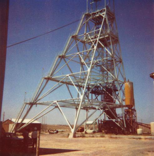
The Sacaton porphyry copper deposit, worked by Asarco as an open pit mine, employed 400 people from the local area.
In an attempt to uncover deeper ore reserves, the company undertook underground mining in the form of block caving east of the pit, with a main shaft sunk 1,800 feet, including more than 500 feet of drifting.
Dimensions of the open pit mine are 3,000 feet in diameter and 980 feet deep including 24 benches, each 40 foot high.
Its daily operations used a fleet of 20 Wabco 8SC 85-ton haul trucks, two 9-cubic-yard electric shovels, several 12-cubic-yard front-end loaders, crushing facilities, a flotation mill, a 300-acre tailings disposal facility, return water impoundment and a 500-acre waste rock dump.
Groundwater and water from Santa Cruz River flows west of the mine were allocated to operate the mine.
A 2.71-mile spur track ran from the Southern Pacific Railroad north to service the Sacaton mine. Concentrates were shipped by rail to Asarco’s smelter in El Paso.
The Sacaton Mine produced 11,000 tons of copper a day between 1972 until it closed in March 1984 due to depletion of its economic ore reserves. Afterward, Asarco attempted to convert the property into a non-hazardous solid waste landfill serving metropolitan Phoenix.
Asarco’s Sacaton Mine was the subject of experimental land remediation efforts during the 1970s. Challenges included an arid environment averaging 7 inches of annual rainfall, adverse pH and a lack of organic matter. Revegetation of steep slopes proved difficult due to rapid water runoff and soil permeation, hindering plants’ ability to absorb water.
A solution involving a drip irrigation system consisting of emitters spaced 10 to 15 feet apart conserved water and provided plants with enough hydration, at a slow rate, to prevent water runoff and allow absorption.
Native shrub and tree species with deeper root systems proved effective in soil retention. Those included palo verdes, mesquite, bursage, brittle bush and desert broom.
As of 2009 Asarco LLC agreed to invest $20 million in the cleanup of its 3,000-acre Sacaton property in an effort to settle longstanding environmental claims against it by the state of Arizona.
William Ascarza is an archivist, historian and author. His latest book, “The Chiricahua Mountains: History and Nature,” is available at Barnes and Noble online. Email him at mining@tucson.com
Sources:
Arizona Department of Mines and Mineral Resources file data, Aug. 12, 1986: Sacaton Mine.
Will C. Barnes. (1988) Arizona Place Names. Tucson: The University of Arizona Press.
Stuart A. Bengson. (1977). Drip irrigation to revegetate mine wastes in an arid environment. Journal of Range Management.
David F. Myrick. 1975. Railroads of Arizona Vol. I. Howell North Books. San Diego.
Steven J. Skotnicki and Charles A Ferguson. June 1996. Geologic Map of the Sacaton Mountains, Pinal County, Arizona. Arizona Geological Survey. Open-File Report 96-10.


