

Then and Now photos of Tucson, Southern Arizona
Another round of Then and Now photos from the archives of the Arizona Daily Star and Tucson Citizen. Star photographer A.E. Araiza traveled back to the same spots in 2017 to document the changes.
Then and Now: Tucson Airport terminal

The terminal building at the Tucson Municipal Airport, now known as the Tucson International Airport, ca. 1940s. Passengers waited in the shade of a long porch that extended from the terminal before walking to an airplane and climbing portable stairs to board the plane. The old terminal is still standing, and is located on the airport's west ramp.
Then and Now: Tucson Airport terminal

The former terminal at Tucson Municipal Airport in Tucson on March 23, 2017.
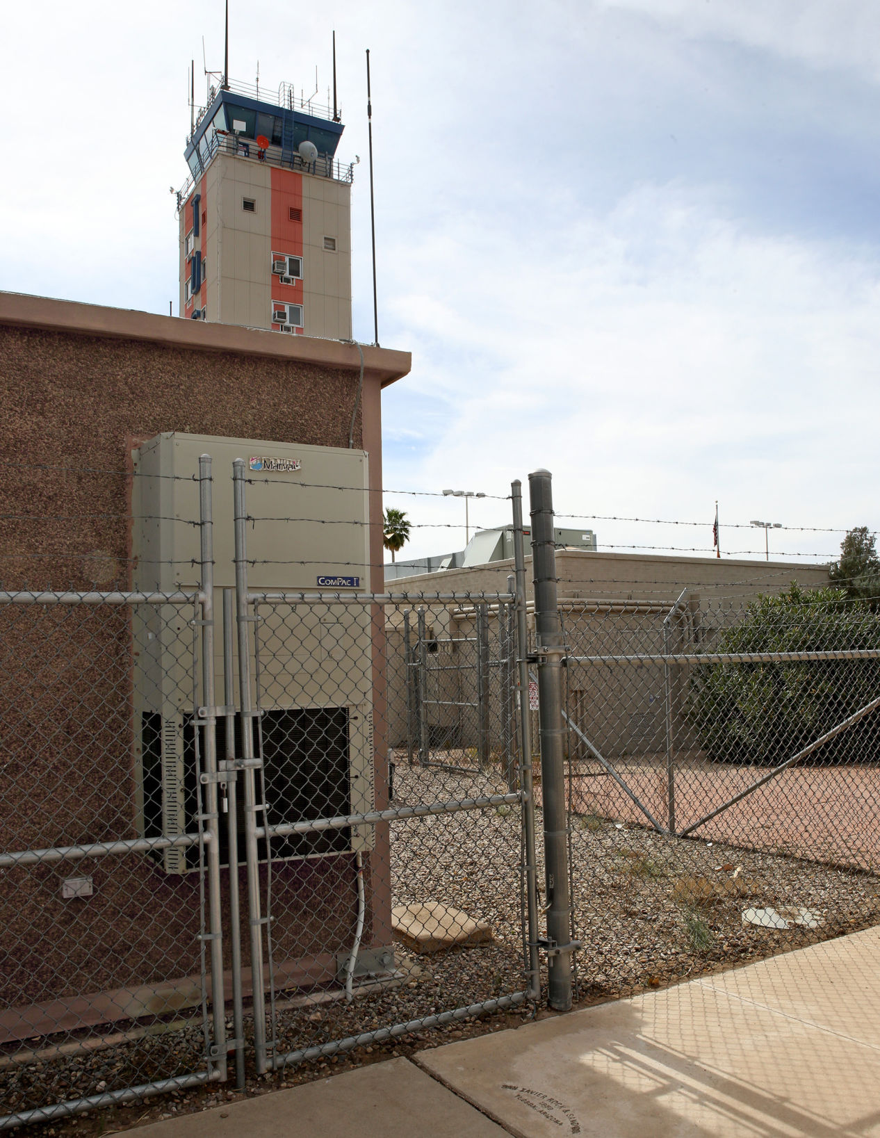
Then and Now: Tucson Airport tower

Members of the Tucson Airport Authority head for the new control tower and operations building at Tucson’s Municipal Airport for their annual meeting around January 13, 1958. The new structure is more than 11 stories tall and is expected to be occupied by May 1958.
Tucson Airport tower

The iconic Tucson International Airport Executive Terminal, which served as the main control tower until it was replaced in 2016 by a new tower across the runway.
Then and Now: Tucson Airport RONtel hotel

An undated photograph of the RONtel at the base of the Tucson Airport tower.
Then and Now: Tucson Airport RONtel hotel

The Rontel Office Building, at 7075 S. Plumer Avenue, was once a motel but has been converted to office space near the Executive Terminal at the Tucson International Airport on March 15, 2017.
Then and Now: Tucson Airport RONtel hotel

A swimming pool at the base of the tower in this undated photograph at the Tucson International Airport.
Then and Now: Tucson Airport RONtel hotel
The southwest end of the old RONtel building, at 2075 S Plumer Ave., once had a swimming pool that may have been filled in between 1987 and 1989 but it is long gone in Tucson on March 15, 2017. Part of a backup generator for the old executive tower is in its place.
Then and Now: Kinsley's Lake

A couple of cars stop on the side of the road at Kinsley's Lake along the Old Nogales Highway in Arivaca Junction in this undated photo. Rancher Otho Kinsley built the lake which is located across the road from the Cow Palace restaurant, a long-time landmark in the area.
Then and Now: Kinsley's Lake

Kinsley's Lake, or what remains of it, was part of the Otho Kinsley's Ranch in Arivaca Junction, Ariz., south of Tucson on March 21, 2017. Kinsley dug out the area to make the lake across the Old Nogales Highway from the Cow Palace restaurant.
Then and Now: Kinsley's Lake

A man walks along the bottom of the remains of Kingsley’s Lake in Arivaca Junction in this undated photo. Across the Old Nogales Highway is the Cow Palace restaurant, a long-time landmark.
Then and Now: Kinsley's Lake

Kinsley's Lake, or what remains of it, was part of the Otho Kinsley's Ranch in Arivaca Junction, Ariz., south of Tucson on March 21, 2017. Kinsley dug out the area to make the lake across the Old Nogales Highway from the Cow Palace restaurant.
Then and Now: Main Gate

The Anderson Chevron gas station at 745 N. Park Ave. was located near the University of Arizona main gate at Third Street on June 25, 1971.
Then and Now: Main Gate

North Park Avenue, near the University of Arizona Main Gate, features a US Marine recruiting center, a Jimmy Johns, several other assorted restaurants, boutiques and an occasional passing street car in Tucson on March 15, 2017.
Then and Now: Halfway Station

The old Halfway Station just south of Elephant Head Road, around 27900 S Old Nogales Highway, as it was on October 1, 1980. It has long been considered to be the half way point between Tucson and Nogales.
Then and Now: Halfway Station

The old Halfway Station, given that name because of its location in Amado, Ariz., has seen better days but still stands on March 21, 2017. The old station, as well as the area near Arivaca Junction, got its name from its location along the Old Nogales Highway, halfway between Tucson and Nogales.
Then and Now: Peña Blanca Lake

Boats are lined up along the bank of the boat landing at Pena Blanca Lake in March 1959. Winter rains and snow pack filled the lake behind the dam. The lake was created for recreational purposes by stocking it with fish and allowing rowboats, canoes and sailboats on the water.
Then and Now: Peña Blanca Lake

The boat ramp at Peña Blanca Lake, which was created in 1957 by the state game and fish department, makes it easier for boats to enter and exit the lake. It is located northwest of Nogales, Ariz., on March 21, 2017. Mercury contamination, possibly from the old mines in the area, necessitated its closure and dredging in the past. It has been reopened and is stocked with Rainbow Trout but it also has Channel Catfish and Largemouth Bass.
Then and Now: Peña Blanca Lake

A little girl gets her photgraph taken along the edge of Peña Blanca Lake near Nogales, Ariz., around March 21, 1958. Winter rains and snow pack has started to allow the lake to fill behind the dam. The lake is expected to be used for recreational purposes by stocking it with fish and allowing rowboats, canoes and sailboats on the water.
Then and Now: Peña Blanca Lake

Oak and mesqute have increased in size along the banks of Peña Blanca Lake, which was created in 1957 by the state game and fish department. It is located northwest of Nogales, Ariz., on March 21, 2017. Mercury contamination, possibly from the old mines in the area, necessitated its closure and dredging in the past. It has been reopened and is stocked with Rainbow Trout but it also has Channel Catfish and Largemouth Bass.
Then and Now: Peña Blanca Lake

The boat ramp at Peña Blanca Lake, which was created in 1957 by the state game and fish department, makes it easier for boats to enter and exit the lake. It is located northwest of Nogales, Ariz., on March 21, 2017. Mercury contamination, possibly from the old mines in the area, necessitated its closure and dredging in the past. It has been reopened and is stocked with Rainbow Trout but it also has Channel Catfish and Largemouth Bass.
Then and Now: Peña Blanca Lake

Support facilities, such as a motel and restaurant were built at Pena Blanca Lake in March 1959. Winter rains and snow pack filled the lake behind the dam. The lake was created for recreational purposes by stocking it with fish and allowing rowboats, canoes and sailboats on the water.
Then and Now: Peña Blanca Lake

Boats are tied up along the dock at the boat landing at Pena Blanca Lake in March 1959. Winter rains and snow pack filled the lake behind the dam. The lake was created for recreational purposes by stocking it with fish and allowing rowboats, canoes and sailboats on the water.
Then and Now: Peña Blanca Lake

The parking lot at Peña Blanca Lake allows for vehicles to park above the boat ramp and lake. It is located northwest of Nogales, Ariz., on March 21, 2017. Mercury contamination, possibly from the old mines in the area, necessitated its closure and dredging in the past. It has been reopened and is stocked with Rainbow Trout but it also has Channel Catfish and Largemouth Bass.
Then and Now: Pioneer National Title Insurance Building

The Pioneer National Title Insurance Building, on 45 W Pennington at North Church Ave, was renamed from the Tucson Title Company on Mar 1, 1971.
Then and Now: Pioneer National Title Insurance Building

The southwest corner of the park, near the Joel D Valdez Main Library, is adjacent to the Old Pima County Courthouse at West Pennington Street and North Church Avenue in Tucson on March 15, 2017.
Then and Now: Pirate's Den

Still under construction on July 9, 1971, the new Pirate’s Den, at 6475 E Golf Links Rd., is starting to take shape. At one time the popular nightclub became a venue for entertainers such as Chubby Checkers, Fabian and the Platters.
Then and Now: Pirate's Den

The Raiders Reef Show Club is now an adult entertainment club, at 6475 E Golf Links Rd., in Tucson on March 15, 2017.

Rick Wiley
Photo editor

Partisan members of the Independent Redistricting Commission are making last-minute efforts to draw maps that would help their political parties through the 2030 election.

Bisbee, Ajo and Tubac are finalists for favorite small town in the southwest.

Supervisor Ally Miller voted against accepting the donation, citing concerns about those ongoing costs.

The housing and retail project would be located at the southern end of Fourth Avenue at Eighth Street and Stevens Avenue on the west.