

Ask the Weather Guys: 10 best questions about spring
- Updated
March has begun, which means spring is around the corner. In honor of the occasion, we are rolling out a collection of the best questions about spring answered by the Weather Guys.
- STEVEN A. ACKERMAN and JONATHAN MARTIN | UW-Madison department of atmospheric and oceanic sciences
- Updated
Q What's so special about March?
A The famous proverb concerning March weather is "In like a lion, out like a lamb," suggesting that the first part of the month respects its pedigree and is winterlike while the latter part foreshadows the promise of spring and summer. Is this really true in southern Wisconsin?
As it turns out, the month with the greatest difference between the all-time warmest and coldest days is March. The record coldest March day in Madison's history occurred on March 1, 1962, when the temperature dipped to minus-29. That same day, the high temperature reached only 3 degrees, a remarkable 32-degree increase over the course of the day.
The day with the all-time lowest high temperature in March occurred on March 2, 1943, when the temperature climbed to only 1 degree. On the other side of the spectrum, the all-time warmest March day in Madison - 82 degrees - has happened twice; March 29, 1986, and March 31, 1981.
The highest daily low March temperature in Madison occurred on March 26, 2007: 59 degrees for a low with a high of 79 degrees. The difference between all-time highs and lows of 111 degrees in March far exceeds the difference for any other month with April coming closest with a 94-degree difference.
A similar set of records exist for Milwaukee; the difference in March is 92 degrees, with December finishing second at 86 degrees.
Thus, with all the cold records occurring at the beginning of the month and all the warm records occurring at the end, it certainly appears that the old proverb is true for southern Wisconsin.
- STEVEN A. ACKERMAN and JONATHAN MARTIN | UW-Madison department of atmospheric and oceanic sciences
- Updated
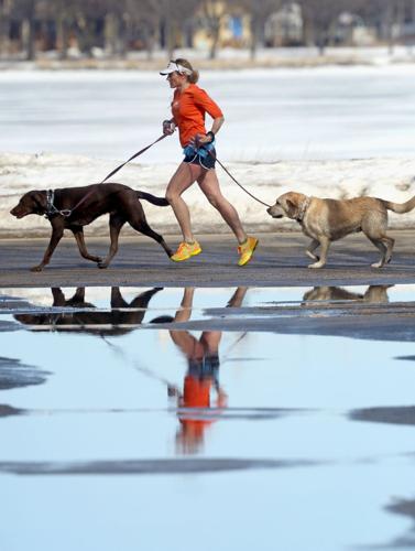
Q Is there such a thing as a windy season?
A After a rather cloudy and blustery start to May, we were recently asked if there are certain particularly windy times of year here in Madison.
Of course, a windy day can come along just about any time of year (the record gust of 83 mph in Madison occurred in June 1975) but the climatology suggests that March and April are the windiest months of the year with average wind speeds of 11.3 and 11.4 mph, respectively. November through February are not far behind logging a four-month average of 10.5 mph.
That it's windier during the cold season is not surprising as that time of year is characterized by the highest frequency of mid-latitude cyclone activity. Mid-latitude cyclones are large in scale, covering several states simultaneously, and are often associated with very large differences in sea-level pressure over small distances. It is these pressure differences that drive the wind.
The particular maximum in March and April may reflect the fact that late winter and early spring storms have a higher chance of containing thunderstorms that can locally enhance the winds. It may also be that on a sunny March or April day the daytime heating contributes to a slightly breezier day than might be observed on a similarly sunny day in the depth of winter.
It is interesting that the windiest month (April) occurs when plants are most in need of assistance in spreading pollen and reproducing. The power of evolution!

- STEVEN A. ACKERMAN and JONATHAN MARTIN | UW-Madison department of atmospheric and oceanic sciences
- Updated
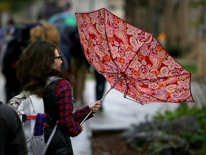
Q. Why are there April showers?
A. As we head into the second half of April, recent weather has reminded us all of the old saying, “April showers bring May flowers.”
The question, of course, is why does April bring the showers?
First of all, is it actually true that April has an unusually large number of days on which it precipitates? Records for number of rainy days per month are hard to come by, but the showery reputation of April is likely the result of two, interrelated physical processes that characterize the arrival of spring.
First, as the hemisphere warms up at the end of winter and beginning of spring, the large pool of cold air that surrounds the pole in an irregular shape begins to shrink. A predominant way that this shrinking occurs is through the cutting off of local pools of cold air into isolated masses that become orphaned well south of the main reservoir. These features are known as “cut off lows.”
Simultaneously, the sun angle increases dramatically after the equinox (near March 21) and so the heating that can occur during the daytime increases as well. The combination of increased heating of the now snow-free surface and the presence of isolated cold air masses above the surface in the cut off lows, produces the perfect atmospheric conditions for isolated, convective rain showers on days that might begin with sunshine.
Throw in the regular passage of mid-latitude cyclones with their more organized precipitation shields and you have the chance to get a lot of rainy days in the transition month of April.
By May, the cyclone part of the rain threat is often reduced substantially as the jet stream migrates northward with the continued warming of the hemisphere.
- STEVEN A. ACKERMAN and JONATHAN MARTIN | UW-Madison department of atmospheric and oceanic sciences
- Updated
Q: Why doesn't spring start on the same date every year?
A: According to the astronomical definition, spring occurs when the sun's rays strike the equator at noon at an angle that is directly overhead. This time varies from year to year due to variations in the Earth's orbit around the Sun.
In the northern hemisphere, the vernal equinox occurs between March 19 and 23, but usually on March 21. This year, astronomical spring arrived in Madison on Friday at around 6:45 a.m. During the equinoxes, all locations on Earth experience 12 hours of daylight and 12 hours of darkness. The sun rises due east and sets due west.
But there are other definitions of spring. The seasons result from the tilt of the Earth and its yearly circling of the sun. Spring marks the transition from winter to summer. So meteorologists often define the three months of spring as March through May. By that definition, spring would begin on March 1. We might also define spring as the day on which, if there is precipitation, it is more likely to be in the form of rain than snow. For southern Wisconsin, that occurs later in March. We may also define spring based on the appearance of a particular flower, the blooming of certain trees, or the return of specific migrating birds.
Whatever the definition, during spring the length of daylight hours is increasing and the air is warming. That's welcome news for many people.
- STEVEN A. ACKERMAN and JONATHAN MARTIN | UW-Madison department of atmospheric and oceanic sciences
- Updated
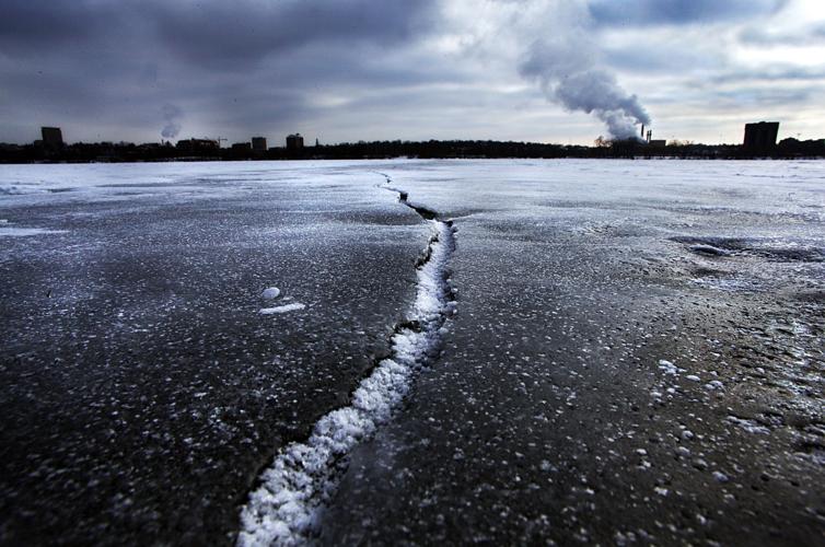
Q. How do ice ridges form on the lake?
A. Lake ice formation is dynamic. Even when a lake is completely frozen, the ice is not stagnant. It expands and contracts as it warms and cools.
Differences in day and night temperatures can be large enough to cause the ice to crack. As the air temperature drops at night, lake ice cools and contracts. Since the ice is stuck to the shoreline, the entire sheet cannot contract as a whole, so cracks develop in the ice.
When the ice warms during the day, it expands. This expansion can cause a collision between both sides of the crack, which can cause the ice to buckle up at that pressure point. This cracking and the collisions and buckling can cause loud sounds.
This expansion can even push the ice up on shore. This can happen because, at night, the ice contracts and cracks develop which can fill with water. This water freezes. In the day, as the ice warms it expands, pushing some ice up on shore.
A layer of snow on the ice acts like a blanket, insulating the ice. This keeps the ice from warming or cooling too much. Snow-free conditions can lead to the greatest temperature changes in the ice, particularly in early spring when the weather can change so much in one day. For instance, Madison just came out of a cold snap, followed by warm weather with temperatures in the 60s. This caused ice on the city's lakes to warm and expand. We saw new buckling of ice as a result.
- STEVEN A. ACKERMAN and JONATHAN MARTIN | UW-Madison department of atmospheric and oceanic sciences
- Updated
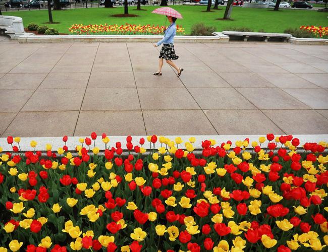
When does spring begin?
Spring marks the transition from winter to summer. Meteorologists often define the three months of spring as March through May. By that definition, spring would begin on March 1.
We might also define spring as the day on which, if there is precipitation, it is more likely to be in the form of rain than snow.
For southern Wisconsin, that occurs later in the month of March.
We may also define spring based on the appearance of a particular flower, the blooming of certain trees, or the return of specific migrating birds. These are the phenological signs of spring.
Some mark spring by the increase in the number of potholes.
According to the astronomical definition, spring occurs when the sun’s rays strike the equator at noon at an angle that is directly overhead.
This particular time varies from year to year due to variations in the Earth’s orbit about the Sun.
In the Northern Hemisphere the vernal (or spring) equinox (equi, “equal,” and nox, “night”) occurs sometime between March 19 and 23, but often on March 20 or 21.
This year, astronomical spring arrives on March 20 at around 5:45 p.m.
During the equinoxes all locations on Earth experience 12 hours of daylight and 12 hours of darkness. The sun rises due east and sets due west.
The seasons result from the tilt of the Earth and its yearly circling of the sun.
Whatever the definition, during spring the length of daylight hours is increasing and the air is warming.
That’s welcome news for many people, particularly after our cold February.
— Steve Ackerman and Jonathan Martin, professors in the UW-Madison department of atmospheric and oceanic sciences, are guests on WHA radio (970 AM) at 11:45 a.m. the last Monday of each month.
- STEVEN A. ACKERMAN and JONATHAN MARTIN | UW-Madison department of atmospheric and oceanic sciences
- Updated
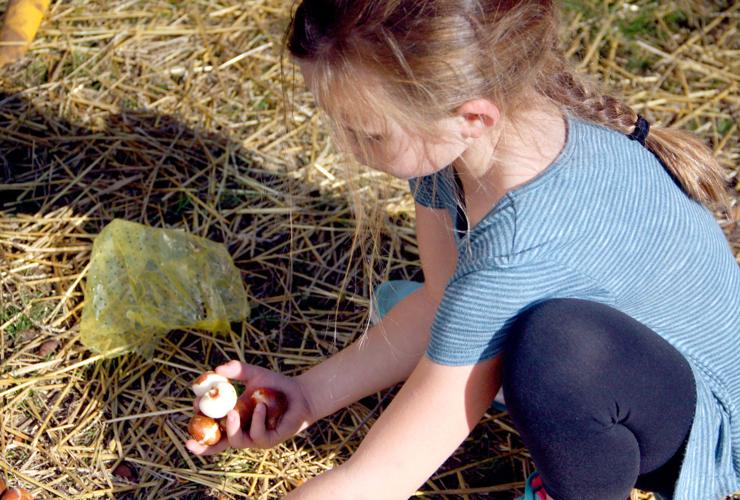
When is the last frost?
The growing season is often defined as the number of days between the last time the temperature was 32 degrees in spring and the first time the temperature falls to 32 in fall.
The latest frost in spring is important to gardeners as they seek to plant after a long winter, and for most plants it is wise to do so when the temperatures are likely to remain warmer than 32 degrees.
For our region, based on temperature observations between 1981 and 2010, the median date of the last frost is between May 1 and May 10. That is why many gardeners consider Mother’s Day a good day to plant.
One reason for the variation in the last frost date is how the first frost date is defined.
Giving the median date of last frost means that there is still a 50 percent chance that a frost will occur after this date. Some definitions require that there is only a 10 percent chance of a 32 or lower temperature.
Some sites use a different 30-year period, for example, between 1951 to 1980. As it turns out, our nighttime minimum temperatures have been getting warmer, so the last frost date has been moving earlier in the spring.
The change is not much for Dane County, but in northwestern Wisconsin, the last frost date now occurs about two weeks earlier than it did in 1950.
According to the Wisconsin State Climatology Office, for Madison, based again on the 1981-2010 time period, the median date for a temperature of 32 is May 2, and it isn’t until May 20 that the probability of an occurrence of 32 has dropped to 10 percent. On April 18, there’s a 90 percent chance of a later occurrence of 32 degrees.
So, if you have not yet done your planting, now would be a good time.
— Steve Ackerman and Jonathan Martin,
professors in the UW-Madison
department of atmospheric and oceanic sciences, are guests on WHA radio
(970 AM) at 11:45 a.m.
the last Monday of each month.
- STEVEN A. ACKERMAN and JONATHAN MARTIN | UW-Madison department of atmospheric and oceanic sciences
- Updated
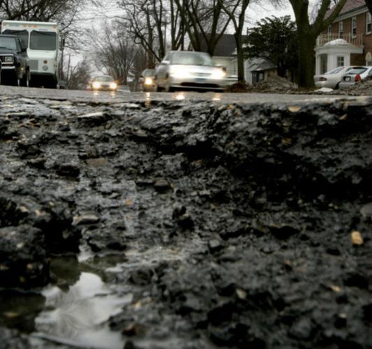
How do potholes form?
Potholes result from a combination of traffic and water.
Roadways are constructed in layers. The top layer is water resistant and curved to drain water off the road and onto the shoulder.
A road surface develops cracks due to the stresses caused by traffic and because of the heating and cooling of the surface. During the day, the sun warms the roadway causing it to expand a small amount, while nighttime cooling causes the road to contract.
Even small cracks in the surface allow water to seep below the surface into the underlying materials. During the cold nights the water freezes and expands.
During a clear sky day, the sun warms the road which melts the underlying ice. The melted water can flow to a different section of the roadway.
When the ice melts, the pavement contracts and leaves gaps in the surface under the pavement, where again water can get in and be trapped.
Stresses on the roadway from traffic can widen existing cracks, allowing more water to seep in and freeze during the night. This freeze-thaw cycle will weaken the surface.
Traffic over the weak spot in the road causes the roadway material to break down, and when that broken-down material is removed by constant traffic, it creates a pothole.
We see many potholes develop in the early spring as that is when we get nighttime temperatures below freezing and daytime temperatures above freezing due to the longer daylight hours.
This temperature cycle results in several freeze-thaw cycles that cause potholes. Early spring can be considered pothole season.
Repairing potholes is a challenge as one has to not only fill the hole but also seal it to keep water from getting into any cracks.
— Steve Ackerman and Jonathan Martin, professors in the
UW-Madison department of atmospheric and oceanic
sciences, are guests on WHA radio (970 AM) at 11:45 a.m.
the last Monday of each month.
- STEVEN A. ACKERMAN and JONATHAN MARTIN | UW-Madison department of atmospheric and oceanic sciences
- Updated
Q: When will spring arrive?
A: By two measures, spring has arrived. Astronomically, spring, or the vernal equinox, occurs around March 20 each year. It is defined as when the tilt of Earth’s axis is inclined neither toward nor away from the Sun. The moment that marks the beginning of spring is when the sun is directly overhead at the equator. This year that occurred on March 20, when the maximum temperature in Madison was only 21 degrees.
Meteorologically, we can define the first day of spring as when, based on at least 30 years of observations, the probability is greater than 50 percent that should some sort of precipitation fall, it will be rain rather than snow. That date has also passed. For southern Wisconsin, that calendar day is around March 16.
Some people define spring as the first day they see a robin. We’ve seen flocks of robins in Madison this month, so that day also has passed.
While various definitions of spring indicate it has arrived, it sure seems wintry. From a climate perspective, it is not common to have this much snow on the ground after the vernal equinox. The outlook for the coming week includes below-normal temperatures.
Springtime is generally considered to be the three months of March, April and May. The official National Oceanic and Atmospheric Administration, or NOAA, outlook for spring is for warmer-than-normal weather across most of the U.S. There will have to be some warm months ahead to have that happen in Madison.
On a related note: NOAA cautions that the melting of late-season snow may cause minor to moderate flooding in the upper Mississippi River basin, including southern Wisconsin.
- STEVEN A. ACKERMAN and JONATHAN MARTIN | UW-Madison department of atmospheric and oceanic sciences
- Updated
What is an equinox?
The equinoxes (from “equi,” meaning “equal,” and “nox,” or “night”) occur when the sun’s rays strike the equator at noon at an angle of 90 degrees.
In the Northern Hemisphere, the vernal or spring equinox occurs around March 20, and the autumnal or fall equinox occurs on September 22 or 23.
During the equinoxes, the sun is above the horizon for all locations on Earth for 12 hours. This year the fall equinox occurs on Sept. 22 at 9:29 p.m.
The tilt of the Earth’s axis is responsible for the seasonal variation in the amount of solar energy distributed at the top of the atmosphere and plays a key role in determining the seasonal variation in surface temperature.
The Earth’s axis of rotation is tilted at an angle of 23.5 degrees from its orbital plane. Because the Earth’s axis of spin always points in the same direction — toward the North Star — the orientation of the Earth’s axis to the sun is always changing as the Earth orbits around the sun.
As this orientation changes throughout the year, so does the distribution of sunlight on the Earth’s surface at any given latitude, and this is the cause of the seasons.
On the equinoxes, the axis is not pointed at or away from the sun. This results in all areas experiencing a little more than 12 hours of daylight.
The September equinox is considered by many to be a sign of the beginning of fall in the Northern Hemisphere, and a marker of spring in the Southern Hemisphere.
— Steve Ackerman and Jonathan Martin, professors in the UW-Madison department of atmospheric and oceanic sciences, are guests on WHA radio (970 AM) at 11:45 a.m. the last Monday of each month.
More like this...
- STEVEN A. ACKERMAN and JONATHAN MARTIN | UW-Madison department of atmospheric and oceanic sciences
Q What's so special about March?
A The famous proverb concerning March weather is "In like a lion, out like a lamb," suggesting that the first part of the month respects its pedigree and is winterlike while the latter part foreshadows the promise of spring and summer. Is this really true in southern Wisconsin?
As it turns out, the month with the greatest difference between the all-time warmest and coldest days is March. The record coldest March day in Madison's history occurred on March 1, 1962, when the temperature dipped to minus-29. That same day, the high temperature reached only 3 degrees, a remarkable 32-degree increase over the course of the day.
The day with the all-time lowest high temperature in March occurred on March 2, 1943, when the temperature climbed to only 1 degree. On the other side of the spectrum, the all-time warmest March day in Madison - 82 degrees - has happened twice; March 29, 1986, and March 31, 1981.
The highest daily low March temperature in Madison occurred on March 26, 2007: 59 degrees for a low with a high of 79 degrees. The difference between all-time highs and lows of 111 degrees in March far exceeds the difference for any other month with April coming closest with a 94-degree difference.
A similar set of records exist for Milwaukee; the difference in March is 92 degrees, with December finishing second at 86 degrees.
Thus, with all the cold records occurring at the beginning of the month and all the warm records occurring at the end, it certainly appears that the old proverb is true for southern Wisconsin.
- STEVEN A. ACKERMAN and JONATHAN MARTIN | UW-Madison department of atmospheric and oceanic sciences
Q Is there such a thing as a windy season?
A After a rather cloudy and blustery start to May, we were recently asked if there are certain particularly windy times of year here in Madison.
Of course, a windy day can come along just about any time of year (the record gust of 83 mph in Madison occurred in June 1975) but the climatology suggests that March and April are the windiest months of the year with average wind speeds of 11.3 and 11.4 mph, respectively. November through February are not far behind logging a four-month average of 10.5 mph.
That it's windier during the cold season is not surprising as that time of year is characterized by the highest frequency of mid-latitude cyclone activity. Mid-latitude cyclones are large in scale, covering several states simultaneously, and are often associated with very large differences in sea-level pressure over small distances. It is these pressure differences that drive the wind.
The particular maximum in March and April may reflect the fact that late winter and early spring storms have a higher chance of containing thunderstorms that can locally enhance the winds. It may also be that on a sunny March or April day the daytime heating contributes to a slightly breezier day than might be observed on a similarly sunny day in the depth of winter.
It is interesting that the windiest month (April) occurs when plants are most in need of assistance in spreading pollen and reproducing. The power of evolution!
- STEVEN A. ACKERMAN and JONATHAN MARTIN | UW-Madison department of atmospheric and oceanic sciences
Q. Why are there April showers?
A. As we head into the second half of April, recent weather has reminded us all of the old saying, “April showers bring May flowers.”
The question, of course, is why does April bring the showers?
First of all, is it actually true that April has an unusually large number of days on which it precipitates? Records for number of rainy days per month are hard to come by, but the showery reputation of April is likely the result of two, interrelated physical processes that characterize the arrival of spring.
First, as the hemisphere warms up at the end of winter and beginning of spring, the large pool of cold air that surrounds the pole in an irregular shape begins to shrink. A predominant way that this shrinking occurs is through the cutting off of local pools of cold air into isolated masses that become orphaned well south of the main reservoir. These features are known as “cut off lows.”
Simultaneously, the sun angle increases dramatically after the equinox (near March 21) and so the heating that can occur during the daytime increases as well. The combination of increased heating of the now snow-free surface and the presence of isolated cold air masses above the surface in the cut off lows, produces the perfect atmospheric conditions for isolated, convective rain showers on days that might begin with sunshine.
Throw in the regular passage of mid-latitude cyclones with their more organized precipitation shields and you have the chance to get a lot of rainy days in the transition month of April.
By May, the cyclone part of the rain threat is often reduced substantially as the jet stream migrates northward with the continued warming of the hemisphere.
- STEVEN A. ACKERMAN and JONATHAN MARTIN | UW-Madison department of atmospheric and oceanic sciences
Q: Why doesn't spring start on the same date every year?
A: According to the astronomical definition, spring occurs when the sun's rays strike the equator at noon at an angle that is directly overhead. This time varies from year to year due to variations in the Earth's orbit around the Sun.
In the northern hemisphere, the vernal equinox occurs between March 19 and 23, but usually on March 21. This year, astronomical spring arrived in Madison on Friday at around 6:45 a.m. During the equinoxes, all locations on Earth experience 12 hours of daylight and 12 hours of darkness. The sun rises due east and sets due west.
But there are other definitions of spring. The seasons result from the tilt of the Earth and its yearly circling of the sun. Spring marks the transition from winter to summer. So meteorologists often define the three months of spring as March through May. By that definition, spring would begin on March 1. We might also define spring as the day on which, if there is precipitation, it is more likely to be in the form of rain than snow. For southern Wisconsin, that occurs later in March. We may also define spring based on the appearance of a particular flower, the blooming of certain trees, or the return of specific migrating birds.
Whatever the definition, during spring the length of daylight hours is increasing and the air is warming. That's welcome news for many people.
- STEVEN A. ACKERMAN and JONATHAN MARTIN | UW-Madison department of atmospheric and oceanic sciences
Q. How do ice ridges form on the lake?
A. Lake ice formation is dynamic. Even when a lake is completely frozen, the ice is not stagnant. It expands and contracts as it warms and cools.
Differences in day and night temperatures can be large enough to cause the ice to crack. As the air temperature drops at night, lake ice cools and contracts. Since the ice is stuck to the shoreline, the entire sheet cannot contract as a whole, so cracks develop in the ice.
When the ice warms during the day, it expands. This expansion can cause a collision between both sides of the crack, which can cause the ice to buckle up at that pressure point. This cracking and the collisions and buckling can cause loud sounds.
This expansion can even push the ice up on shore. This can happen because, at night, the ice contracts and cracks develop which can fill with water. This water freezes. In the day, as the ice warms it expands, pushing some ice up on shore.
A layer of snow on the ice acts like a blanket, insulating the ice. This keeps the ice from warming or cooling too much. Snow-free conditions can lead to the greatest temperature changes in the ice, particularly in early spring when the weather can change so much in one day. For instance, Madison just came out of a cold snap, followed by warm weather with temperatures in the 60s. This caused ice on the city's lakes to warm and expand. We saw new buckling of ice as a result.
- STEVEN A. ACKERMAN and JONATHAN MARTIN | UW-Madison department of atmospheric and oceanic sciences
When does spring begin?
Spring marks the transition from winter to summer. Meteorologists often define the three months of spring as March through May. By that definition, spring would begin on March 1.
We might also define spring as the day on which, if there is precipitation, it is more likely to be in the form of rain than snow.
For southern Wisconsin, that occurs later in the month of March.
We may also define spring based on the appearance of a particular flower, the blooming of certain trees, or the return of specific migrating birds. These are the phenological signs of spring.
Some mark spring by the increase in the number of potholes.
According to the astronomical definition, spring occurs when the sun’s rays strike the equator at noon at an angle that is directly overhead.
This particular time varies from year to year due to variations in the Earth’s orbit about the Sun.
In the Northern Hemisphere the vernal (or spring) equinox (equi, “equal,” and nox, “night”) occurs sometime between March 19 and 23, but often on March 20 or 21.
This year, astronomical spring arrives on March 20 at around 5:45 p.m.
During the equinoxes all locations on Earth experience 12 hours of daylight and 12 hours of darkness. The sun rises due east and sets due west.
The seasons result from the tilt of the Earth and its yearly circling of the sun.
Whatever the definition, during spring the length of daylight hours is increasing and the air is warming.
That’s welcome news for many people, particularly after our cold February.
— Steve Ackerman and Jonathan Martin, professors in the UW-Madison department of atmospheric and oceanic sciences, are guests on WHA radio (970 AM) at 11:45 a.m. the last Monday of each month.
- STEVEN A. ACKERMAN and JONATHAN MARTIN | UW-Madison department of atmospheric and oceanic sciences
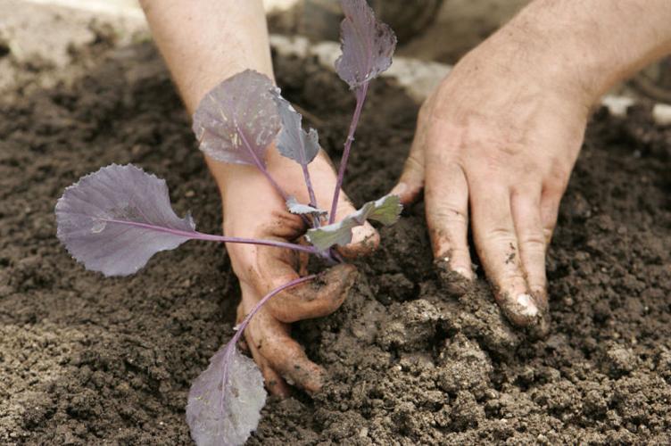
When is the last frost?
The growing season is often defined as the number of days between the last time the temperature was 32 degrees in spring and the first time the temperature falls to 32 in fall.
The latest frost in spring is important to gardeners as they seek to plant after a long winter, and for most plants it is wise to do so when the temperatures are likely to remain warmer than 32 degrees.
For our region, based on temperature observations between 1981 and 2010, the median date of the last frost is between May 1 and May 10. That is why many gardeners consider Mother’s Day a good day to plant.
One reason for the variation in the last frost date is how the first frost date is defined.
Giving the median date of last frost means that there is still a 50 percent chance that a frost will occur after this date. Some definitions require that there is only a 10 percent chance of a 32 or lower temperature.
Some sites use a different 30-year period, for example, between 1951 to 1980. As it turns out, our nighttime minimum temperatures have been getting warmer, so the last frost date has been moving earlier in the spring.
The change is not much for Dane County, but in northwestern Wisconsin, the last frost date now occurs about two weeks earlier than it did in 1950.
According to the Wisconsin State Climatology Office, for Madison, based again on the 1981-2010 time period, the median date for a temperature of 32 is May 2, and it isn’t until May 20 that the probability of an occurrence of 32 has dropped to 10 percent. On April 18, there’s a 90 percent chance of a later occurrence of 32 degrees.
So, if you have not yet done your planting, now would be a good time.
— Steve Ackerman and Jonathan Martin,
professors in the UW-Madison
department of atmospheric and oceanic sciences, are guests on WHA radio
(970 AM) at 11:45 a.m.
the last Monday of each month.
- STEVEN A. ACKERMAN and JONATHAN MARTIN | UW-Madison department of atmospheric and oceanic sciences
How do potholes form?
Potholes result from a combination of traffic and water.
Roadways are constructed in layers. The top layer is water resistant and curved to drain water off the road and onto the shoulder.
A road surface develops cracks due to the stresses caused by traffic and because of the heating and cooling of the surface. During the day, the sun warms the roadway causing it to expand a small amount, while nighttime cooling causes the road to contract.
Even small cracks in the surface allow water to seep below the surface into the underlying materials. During the cold nights the water freezes and expands.
During a clear sky day, the sun warms the road which melts the underlying ice. The melted water can flow to a different section of the roadway.
When the ice melts, the pavement contracts and leaves gaps in the surface under the pavement, where again water can get in and be trapped.
Stresses on the roadway from traffic can widen existing cracks, allowing more water to seep in and freeze during the night. This freeze-thaw cycle will weaken the surface.
Traffic over the weak spot in the road causes the roadway material to break down, and when that broken-down material is removed by constant traffic, it creates a pothole.
We see many potholes develop in the early spring as that is when we get nighttime temperatures below freezing and daytime temperatures above freezing due to the longer daylight hours.
This temperature cycle results in several freeze-thaw cycles that cause potholes. Early spring can be considered pothole season.
Repairing potholes is a challenge as one has to not only fill the hole but also seal it to keep water from getting into any cracks.
— Steve Ackerman and Jonathan Martin, professors in the
UW-Madison department of atmospheric and oceanic
sciences, are guests on WHA radio (970 AM) at 11:45 a.m.
the last Monday of each month.
- STEVEN A. ACKERMAN and JONATHAN MARTIN | UW-Madison department of atmospheric and oceanic sciences
Q: When will spring arrive?
A: By two measures, spring has arrived. Astronomically, spring, or the vernal equinox, occurs around March 20 each year. It is defined as when the tilt of Earth’s axis is inclined neither toward nor away from the Sun. The moment that marks the beginning of spring is when the sun is directly overhead at the equator. This year that occurred on March 20, when the maximum temperature in Madison was only 21 degrees.
Meteorologically, we can define the first day of spring as when, based on at least 30 years of observations, the probability is greater than 50 percent that should some sort of precipitation fall, it will be rain rather than snow. That date has also passed. For southern Wisconsin, that calendar day is around March 16.
Some people define spring as the first day they see a robin. We’ve seen flocks of robins in Madison this month, so that day also has passed.
While various definitions of spring indicate it has arrived, it sure seems wintry. From a climate perspective, it is not common to have this much snow on the ground after the vernal equinox. The outlook for the coming week includes below-normal temperatures.
Springtime is generally considered to be the three months of March, April and May. The official National Oceanic and Atmospheric Administration, or NOAA, outlook for spring is for warmer-than-normal weather across most of the U.S. There will have to be some warm months ahead to have that happen in Madison.
On a related note: NOAA cautions that the melting of late-season snow may cause minor to moderate flooding in the upper Mississippi River basin, including southern Wisconsin.
- STEVEN A. ACKERMAN and JONATHAN MARTIN | UW-Madison department of atmospheric and oceanic sciences
What is an equinox?
The equinoxes (from “equi,” meaning “equal,” and “nox,” or “night”) occur when the sun’s rays strike the equator at noon at an angle of 90 degrees.
In the Northern Hemisphere, the vernal or spring equinox occurs around March 20, and the autumnal or fall equinox occurs on September 22 or 23.
During the equinoxes, the sun is above the horizon for all locations on Earth for 12 hours. This year the fall equinox occurs on Sept. 22 at 9:29 p.m.
The tilt of the Earth’s axis is responsible for the seasonal variation in the amount of solar energy distributed at the top of the atmosphere and plays a key role in determining the seasonal variation in surface temperature.
The Earth’s axis of rotation is tilted at an angle of 23.5 degrees from its orbital plane. Because the Earth’s axis of spin always points in the same direction — toward the North Star — the orientation of the Earth’s axis to the sun is always changing as the Earth orbits around the sun.
As this orientation changes throughout the year, so does the distribution of sunlight on the Earth’s surface at any given latitude, and this is the cause of the seasons.
On the equinoxes, the axis is not pointed at or away from the sun. This results in all areas experiencing a little more than 12 hours of daylight.
The September equinox is considered by many to be a sign of the beginning of fall in the Northern Hemisphere, and a marker of spring in the Southern Hemisphere.
— Steve Ackerman and Jonathan Martin, professors in the UW-Madison department of atmospheric and oceanic sciences, are guests on WHA radio (970 AM) at 11:45 a.m. the last Monday of each month.

