


First came the online maps, giving Web users an interactive punch to their old atlases. Then came the satellite imaging, adding a Space Age twist to road travel.
Now, many Tucson-area streets and landmarks will be visible at the ground level — and accessible anywhere on the Internet — as part of a new Google service that will give users a close-up snapshot of the Old Pueblo.
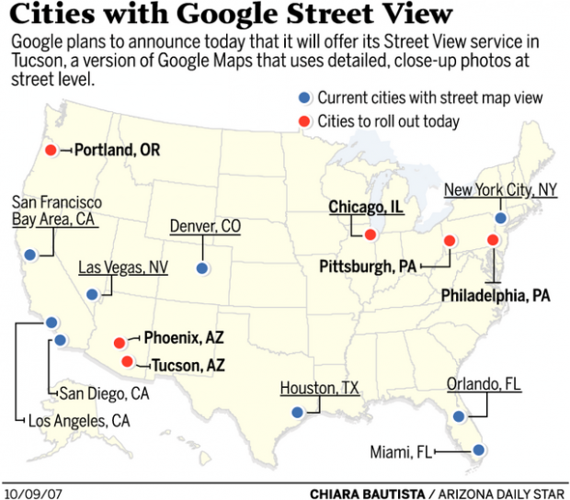
The nascent mapping-turned-imaging service, dubbed Google Street View, debuts online today, and will include Phoenix, Philadelphia and a few other cities. In addition to road maps and satellite views, this new service allows Web users to zoom in as if they were walking down city streets themselves.
But why?
Because Google's mission is to "organize the world's information," said Stephen Chau, Google's Street View product manager. "Our users have tremendous appetites."
People are also reading…
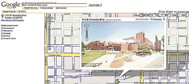
For current Google Maps users, nothing looks that different; streets in Tucson appear like they always have. But after clicking on a button and then on an applicable road, users are greeted with a pop-up window of stitched-together panoramas of streets down which they can navigate.
But the idea was met coolly by some city officials Monday, who have become embattled recently in a debate over the use of surveillance cameras Downtown. While the two projects are different — the cameras are meant to catch criminals, officials say, while Google is meant to casually explore a neighborhood — they are similar in raising questions about photographs in public places.
"It's a kind of voyeurism that is disconcerting," said Ward 6 Councilwoman Nina Trasoff, who represents Downtown. But, she said, "It's reflective of certain changes going on in society," namely that technology is becoming more ubiquitous.
Although Google's images are not real-time-updated (they can be many months old), Google's service also raises questions of privacy in an age where cell-phone cameras can snap people in public just about anywhere.
A privacy advocate said just because it's legal doesn't make it innocuous.
"There is a difference between legal and polite, and this is one of those" situations, said Rebecca Jeschke, a spokeswoman for the San Francisco-based Electronic Frontier Foundation.
The images, Google said, are captured by a vehicle driving down the road while it records its location. There is no law-breaking, one expert said, because the images were obtained in a public area.
And Google said that it is sensitive to privacy and gives users options on the map itself to opt-out of Street View images.
Chau said that after the service's launch in May, "we saw a tremendous amount of positive feedback."
While Google on Monday would not give specifics about just how much of Tucson would be covered, it said Downtown, the University of Arizona and area landmarks would be included.
Tucson was "high on the list" to be a Street View city, partly because of user feedback, although Chau declined to discuss specifics. He also suggested Tucson's proximity to Phoenix was a factor in this most recent rollout.
The two Arizona cities join an existing list of metro areas with Street View capabilities. Los Angeles, San Francisco and New York were among nine whose streets came online earlier this summer.
Regardless of privacy concerns, some Tucsonans seem unfazed by this new technology.
One of them, 20-year-old UA student Patrick Fisher, said Google has "had aerial photography for a long time" as he rested on his bicycle near the Flandrau Science Center — one of the featured landmarks Google previewed for a reporter.
"If someone wants to stalk you, they wouldn't be doing it that way."
On StarNet: Find this story online at azstarnet.com to link to examples in other cities that already have Google's Street View service.
Find more technology news and the latest business headlines throughout the day at www.AzStarBiz.com.