

History records that Chiricahua Apache leader Cochise and U.S. Gen. O.O. Howard negotiated a peace treaty in 1872 at a site along the western edge of what became known as the Dragoon Mountains.
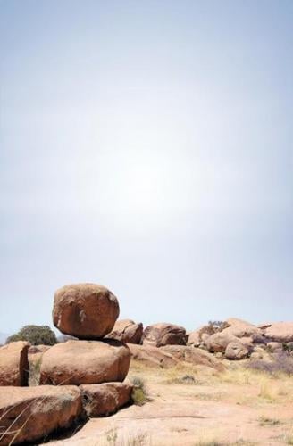
What isn't known is whether they first spent some time playfully climbing like little boys among the spectacular cluster of granite boulders, some the size of a house.
Who knows, it could have put them in an agreeable mood that enabled them to work out their differences.
At Council Rocks, as the place is now called, it's almost impossible to resist the urge to harken back to childhood, bounding from boulder to boulder or squeezing between others to find irresistible little hiding places.
It's a place one can drive to, albeit on a bumpy National Forest road. High-clearance vehicles are recommended, but it can be driven, with caution, in a passenger car. Just park, make a short climb up to the mesa at the base of the mountains and you're there. The elevation is a little under 5,000 feet.
People are also reading…
At the parking area, walk through the gate and follow the path in either direction. The whole area has been used for hundreds of years, and there are multiple crisscrossing paths that lead up to Council Rocks.
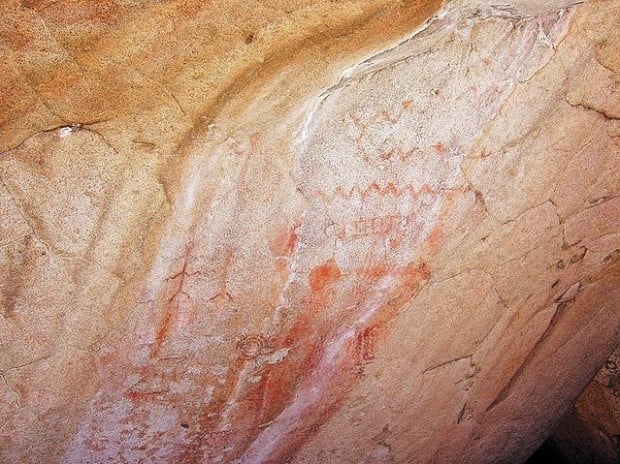
One massive boulder is a veritable gallery of red and orange pictographs. The interpretive sign next to it says they're "reminiscent of designs used by prehistoric Mogollon peoples roughly 1,000 years ago. Some may have been added in early historic times by Apache visitors."
Nearby on other boulders are man-made depressions in the granite — used long ago as mortars for grinding nuts and seeds.
After war broke out between the Apaches and Americans in 1861, Cochise and his band eluded capture for years among the maze of spires and canyons in the upper Dragoons. We now call the place Cochise Stronghold, and it can be reached from either the west or the east side of the range with a vigorous day hike.
Tom Jeffords, who employed riders to carry mail through the Southwest, entered the Stronghold in 1867 to meet with Cochise, and the two became friends. Five years later, Jeffords helped broker the treaty between Howard and Cochise.
The treaty lasted two years. Cochise died in 1874, and the Americans abolished the reservation and sent the remaining Apaches to the San Carlos Reservation.
Today, the area is prime recreational land. On a recent Sunday, there were many groups camping or picnicking along Forest Road 687 leading to Council Rocks, and at least two trailheads that lead into mountains begin there — Slavin Gulch and the West Cochise Stronghold Trail.
Clip 'n' go
Council Rocks
Drive: Take Interstate 10 east to Benson, then Arizona 80 south for 23 miles. About a mile before Tombstone, turn left onto Middlemarch Road, taking the graveled, washboarded road for 10 miles. As you enter Coronado National Forest Land, turn left onto Forest Road 687, then go 6.7 miles and turn right on FR 687K for 0.3 of a mile to the parking area.
Hike: It's a short, somewhat steep climb, perhaps 200 yards, to the boulder-strewn mesa.
Et cetera: From Middlemarch Road to Council Rocks, there are no facilities. Stock and fuel up in St. David, Benson or Tombstone. If you're in a passenger car, consider parking before turning from FR 687 onto FR 687K, as high-clearance vehicles are best for that last 0.3 of a mile.