
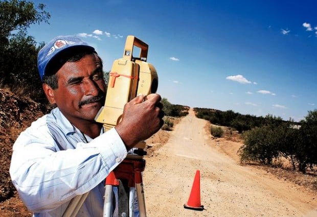
El Sásabe, Sonora.– El gobierno federal de México ya casi termina la pavimentación de la carretera del Norte de Sonora que se convertirá en la primera carretera de calidad que irá del pequeño puerto de entrada en Sásabe hacia México.
El puerto de Sásabe - el más pequeño y con menos tráfico de Arizona - ha estado abierto desde 1916 pero nunca ha sido un puerto muy utilizado como lo son el de San Luis, Nogales y Douglas. Está localizado en un área remota y no muy poblada, y no existen caminos pavimentados que vayan del puerto hacia el interior de México.
Este proyecto cambiará eso al abrir una nueva avenida hacia México para los turistas que no lo han considerado como una opción viable.
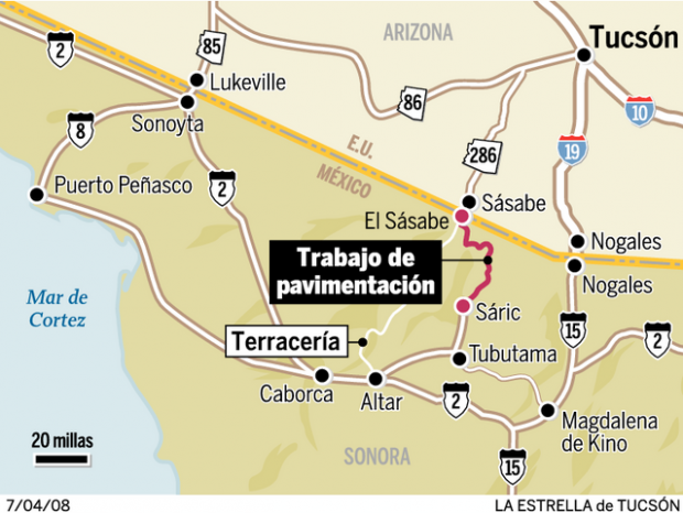
Cuando esté terminado, este camino pavimentado de 54 km entre el pueblo fronterizo de El Sásabe, en Sonora, y Sáric le dará a los viajeros una ruta alternativa hacia el Noroeste de Sonora sin tener que pasar por Nogales o Lukeville - ambos puertos muy transitados. Hay calles pavimentadas de Sáric hacia Magdalena de Kino al Sureste o hacia Altar y Caborca al Suroeste.
People are also reading…
Desde que se iniciaron las obras en junio del 2006, el equipo de trabajo ha terminado 22 km en dos secciones; 12 km de El Sásabe y 10 km hacia la entrada de Sáric , informó Felipe Rivas Castro, encargado de construcción de carreteras para la Secretaría de Comunicaciones y Transportes de Sonora.
Se espera que terminen con un poco más de 25 km para finales del año, reveló Rivas. Esperan terminar los 30 km que faltan para el 2010 o a más tardar para el 2012, cuando el presidente de México, Felipe Calderón concluya su mandato, señaló Rivas.
El gobierno federal ha asignado 84.2 millones de pesos (8.17 millones de dólares) para los primeros tres años de trabajo. Se necesitarán 8 millones de dólares adicionales para terminar todo, informó Rivas.
Autoridades de Aduanas y Protección Fronteriza de Estados Unidos anticipan que la carretera terminada aumentará tanto el tránsito por el puerto de Sásabe, y están considerando mantener abierto el puerto 24 horas al día y agregar otros carriles, señaló Brian Levin, portavoz de Aduanas y Protección Fronteriza.
En el presente, el puerto está abierto de 8 a.m. a 8 p.m. y sólo cuenta con un carril de entrada y otro de salida.
"Para aquellas personas que regresan y no quieren pasar por Nogales, ésta puede ser una ruta alternativa", sugirió Levin.
Una de las tres razones principales por las que el gobierno decidió gastar este dinero en la carretera, fue para atraer más turismo estadounidense a la región, indicó Rivas.
Las autoridades esperan que la nueva carretera atraiga a más turismo que pase por Sásabe y a las poblaciones pequeñas de Tubutama, Átil y Oquitoa - todas éstas son parte de la ruta de las misiones del Padre Kino. Prevén que se convierta en una ruta alterna para entrar y salir de EU, más que pasar por el transitado Nogales, explicó.
Las otras dos razones fueron, conectar El Sásabe, que no es su propia municipalidad, a Sáric , el cual supervisa la población; y también, aumentar la seguridad en lo que se ha convertido en una región peligrosa con traficantes de drogas y humanos, apuntó Rivas.
"Es una carretera estratégica para reforzar la seguridad de la región", dijo. "Es una región en conflicto con el tráfico de drogas y la gente. Necesita una vía de comunicación para que podamos tener más vigilancia, más servicios y cambiar la situación tan marginada que tenemos ahora".
Cuando ya esté terminada, la carretera será mantenida y patrullada por las autoridades del estado de Sonora, así dijo Ramón Anduaga Verdugo quien es Secretario de Comunicaciones y Transportes. No será una carretera de cuota, aseguró.
Antes de este proyecto, los residentes del lugar evitaban este camino de terracería por su mal estado y lejanía. Parte de este camino sigue igual. Las 18 millas entre las dos secciones terminadas todavía son de terracería, y aunque los vehículos pueden pasar, es un recorrido lleno de baches. Como parte del proyecto, se construirán 12 puentes, dijo Rivas.
"Para nosotros, significa que ahora tenemos acceso a una región fronteriza que ha estado olvidada", manifestó Rivas.
Sin embargo, parece que no todos están convencidos de que el nuevo camino pavimentado generará más turismo por Sásabe. Alice Knagge, propietaria de la Tienda Sásabe y administradora de la población de Sásabe, Arizona, dice que el gobierno mexicano debió haber sido más inteligente y pavimentar un camino diferente que vaya directamente de El Sásabe a Altar.
El camino que parece lavadero y al que ella se refiere, sólo lo usan los residentes del área de hace mucho tiempo y las camionetas que llevan inmigrantes indocumentados del bien conocido pueblo de Altar a la frontera cercana. Pero es un camino directo de Altar, más o menos unas 12 millas menos.
"No tiene sentido que el camino llegue a Sáric ", alegó Knagge, quien ha sido propietaria de la Tienda Sásabe desde 1967. "Debería de ir de Sásabe a Altar".
Rivas coincidió que el camino es más corto a Altar pero dijo que no hubiera tenido mucho sentido ya que no hay poblaciones en la ruta, agregó Rivas.
El proyecto actual beneficiará a unos 21 mil 664 residentes de los pueblos de Sáric , Tubutama, Átil, Altar, Oquitoa y Pitiquito, declaró.
En los planes a largo plazo del gobierno está pavimentar el camino a Altar, concluyó.
ENGLISH VERSION
EL SASABE, SONORA — Mexico's federal government is almost halfway done paving a Northern Sonora highway that would become the first quality roadway to lead from the tiny port of entry in Sasabe into Mexico.
The Sasabe port — Arizona's smallest and least-trafficked port — has been open since 1916 but has never become a heavily used port such as those in San Luis, Nogales and Douglas. It's located in a remote, sparsely populated area and there are no paved roads leading from the port into the interior of Mexico.
This project would change that by opening a new avenue into Mexico for tourists who traditionally haven't considered it a viable option.
When finished, this 33.5-mile paved road between the border town of El Sasabe and Sáric would give travelers an alternate route into northwest Sonora without having to go through Nogales or Lukeville — both very busy ports. Paved roads lead out of Sáric to Magdalena de Kino to the southeast or to Altar and Caborca to the southwest.
Since work began in June 2006, crews have finished 13.6 miles in two sections; 7.4 miles out of El Sasabe, and 6.2 miles leading into Sáric , said Felipe Rivas Castro, encargado de construction de carreteras para Sonora de la Secretaría de Comunicaciones y Transportes. They are scheduled to complete slightly more than 15 miles by the end of the year, Rivas Castro said. They hope to finish the remaining 18.5 miles by 2010 at the earliest, or 2012 at the latest, when Mexican President Felipe Calderón's term ends, Rivas Castro said.
The federal government has allotted $84.2 million pesos — or $8.17 million U.S. dollars — for the first three years of work. It will take another $8 million U.S. dollars to complete, Rivas Castro estimated.
U.S. Customs and Border Protection officials anticipate the completed highway will increase traffic through the Sasabe port so much that they have already begun discussing keeping the port open 24 hours a day and adding lanes, said Brian Levin, Customs and Border Protection spokesman. Currently, the port is open from 8 a.m. - 8 p.m. and has one lane in and out.
"For those that are coming back and don't want to got to Nogales, it may prove an alternate route for them," Levin said.
Mexican officials hope that happens.
Attracting more U.S. tourism to the region was one of three principal reasons the government chose to spend money on the highway, Rivas Castro said. Officials hope the new road will attract more tourists through Sasabe and to the small towns of Tubutama, Átil and Oquitoa - all part of Father Kino's Mission Route. They envision it becoming an alternate route in and out of the U.S. rather than going through the busier Nogales, Rivas said.
The other two reasons were to connect El Sasabe, which isn't its own municipality, to Sáric , which oversees the town; and to increase safety in what had become a somewhat dangerous region overrun with drug and human smugglers, Rivas Castro said.
"It is a strategic highway to reinforce the security of the region," said Rivas. "It's a region in conflict with the trafficking of drugs and people. It needs a via for communication so we can have more enforcement, more services and change the marginalized situation that we have now."
When finished, the road will be maintained and patrolled by Sonoran state officials, said Ramon Anduaga Verdugo of the Secretary for Communication and Transportation. It will not be a toll road, he said.
Prior to this project, the rough dirt road was largely avoided by residents due its bad conditions and remoteness. Some of the road still fits that description. The 18 miles in between the two finished sections remains a rough dirt road that, while passable for most vehicles, is bumpy ride in spots. As part of the project, 12 bridges will be built, Rivas Castro said.
"For us, it means we have access to a border region that has been forgotten," Rivas Castro said.
Not everybody, however, is convinced the new paved road will generate more tourism through Sasabe. Alice Knagge, owner of the Sasabe Store and town administrator of Sasabe, Ariz., says the Mexican government would have smarter to pave a different road that runs directly from El Sasabe to Altar.
The washboard dirt road she refers to is only used by longtime residents of the area and vans carrying illegal immigrants from the popular staging town of Altar to near the border. But, it's a straight shot to Altar, about 12 miles shorter.
"It just doesn't make sense that the road goes to Sáric ," said Knagge, who has owned the Sasabe Store since 1967. "It should go from Sasabe to Altar."
Rivas Castro acknowledged that the road is shorter to Altar but said it wouldn't have made as much sense because there are no towns along the route, Rivas said. The current project will benefit 21,664 residents in the towns of Sáric , Tubutama, Átil, Altar, Oquitoa and Pitiquito, he said.
The other road to Altar is scheduled to be paved in the government's long term plans, he said.
● Contact reporter Brady McCombs at 573-4213 or bmccombs@azstarnet.com.
++++++++++++++++++++++++++ The road has already been a boon for Alfonso Garcia Noriega, who lives in Caborca but works in El Sasabe Monday through Friday at the Super Coyote supermarket. He used to drive along a washboard dirt road that goes directly from El Sasabe to Altar. Now, he takes the partly-paved route through Sáric when he heads to and from Caborca, he said.
"It's faster and easier on my truck," said Garcia Noriega in Spanish.
The new road also makes his family's trips to the United States easier. He and his family used to go through Nogales when they traveled to Arizona for shopping. That trip usually took about three to four hours depending on the line at the port, he said. Now, they can be at the Sasabe port of entry in less than two hours.
The best part – there's never lines at the sleepy Sasabe port.
"It's closer and you spend less time at the port," said Garcia Noriega, who lives in Caborca with his wife and two children, a 13-year-old daughter and 9-year-old son.
MORE FROM ALICE KNAGGE, IF YOU WANT. THE ITALICS ARE NEW FROM HER:
Not everybody, however, is convinced the new paved road will generate more tourism through Sasabe. Alice Knagge, owner of the Sasabe Store and town administrator of Sasabe, Ariz., says the Mexican government would have smarter to pave a different road that runs directly from El Sasabe to Altar.
The washboard dirt road she refers to is largely used by longtime residents of the area and vans carrying illegal immigrants from the popular staging town of Altar to near the border. But, it's a straight shot to Altar, about 12 miles shorter that the road through Sáric .
"It just doesn't make sense that the road goes to Sáric ," said Knagge, who has owned the Sasabe Store since 1967. "It should go from Sasabe to Altar."
Justifying the decision based on trying to attract tourism to Sáric , Tubutama, Átil and Oquitoa is a "poor excuse" for a decision that really came down to Sáric having more political power than El Sasabe, she said.
"What is there to see in Sáric and those little towns?" Knagge said. "They are just little Mexican towns. There is nothing to attract the tourists."
And, by choosing to pave the route through Sáric , the government missed an opportunity to entice semi-trailers through the Sasabe port, which would have brought more economic benefits, she said. Truck drivers won't change their routes from Nogales to Sasabe because the road is windy and not direct, Knagge said.
"They are not interested in looking around," said Knagge, about truck drivers. "They are interested in getting from point A to point B with the least possible fuel they can use, especially now."
Customs and Border Protection officials say they aren't expecting an increase in semi trailers through the Sasabe port, either, Levin said. Even though it will be paved, the road is windy and not conducive to trucks, he said.
¿Sabía usted que?
El Puerto de entrada de El Sásabe se estableció alrededor de 1916 con sólo tres carpas a unas cuantas millas de su actual ubicación. En 1917-18, una estructura de adobe fue construida para reemplazar las carpas. El edificio actual fue construido en 1936.
Es el puerto de entrada más chico y con menos tránsito en Arizona. De los 23 mil 237 carros que cruzaron por el puerto en los primeros ocho meses del año fiscal del 2008, es tan sólo una fracción de los 2 mil 86 millones que pasaron por los puertos de entrada de Nogales.
Fuente: Aduanas y Protección Fronteriza de los Estados Unidos. Número por número
Caminos pavimentados entre El Sásabe y Sáric:
33.5 millas de caminos tiene planeado el gobierno mexicano pavimentar entre El Sásabe y Sáric.
13.6 millas pavimentadas hasta ahora.
19.9 millas que quedan por pavimentar.
2006 fue el año en que dio inicio el proyecto.
2010 o 2012 fecha aproximada para que el proyecto concluya.
8.17 millones de dólares dinero asignado por el gobierno federal mexicano hasta la fecha.
8 millones de dólares dinero calculado para terminar el proyecto.
Fuente: Secretaría de Comunicaciones y Transportes.