

Grand treasures of terrain — rugged mountain ridges, rolling oak woodlands and deep-cut canyons — make up the vast Tumacácori Highlands northwest of Nogales. Wildlife flourishes in this landscape — everything from tiny songbirds to high-flying hawks, from little lizards to magnificent mountain lions. A coalition of environmental groups wants Congress to protect the area as federally designated wilderness. And some legislators, including Rep. Raúl Grijalva, D-Ariz., are working to win support for the proposal. We journeyed into the heart of the Highlands — climbing peaks, driving back roads and delving deep into canyons — for a close-up look. – Doug Kreutz
Red embers of sunset smolder, then flare, on the western horizon as I peer down thousands of feet from a narrow catwalk outside an old fire-watch cabin called the Atascosa Lookout.
"Babo lighting up!" hollers photographer Jack Dykinga, hunching over a tripod and focusing his lens on the distant stone spire of Baboquivari Peak glowing in the last rays of the day.
People are also reading…
We're perched on the rugged crown of a 71,000-acre expanse of national forest terrain south of Tucson known as the Tumacácori Highlands. From the 6,249-foot aerie of the remote Atascosa Lookout to the sheer-walled splendor of Hell's Gate in Peck Canyon, it's a landscape to dazzle the eye, test the stamina and soothe the spirit.
People have noticed. The area's mountains, canyons and oak-studded grasslands are so beautiful, so ecologically diverse that a coalition of environmental groups has proposed protecting the Tumacácori Highlands as a federally designated wilderness area. Organizations supporting the proposal include the Sky Island Alliance, Tucson Audubon Society, National Wildlife Federation and two dozen others. However, many ranchers, miners and off-highway-vehicle enthusiasts oppose the designation.
Jack and I — long familiar with the region but seeking a clearer sense of the place — are making a series of visits to climb high into its mountains, drive its bumpy back roads and backpack deep into its canyons.
This sunset moment at Atascosa Lookout offers the grand overview. Price of admission: a steep 2.75-mile hike to the summit from a trailhead on Ruby Road northwest of Nogales. I survey the vast kingdom below the catwalk.
Mountains: The surrounding Atascosa range is all about standing-up stone-pinnacles, cliffs, bulging boulders and tall towers. To the north are the Tumacácori Mountains, namesake of the highlands and the nearby Tumacácori National Historical Park. To the south rise the Pajarito (Spanish for "Little Bird") Mountains. Farther out, beyond the proposed wilderness, lie Baboquivari, the Santa Rita range, Sierra La Esmeralda across the border in Sonora and the distant Catalinas shrugging over Tucson.
Canyons: Calabasas, Beehive, Bartolo and Pine, to name a few. And another called Peck, where Jack and I will later bed down on a backpacking trek.
High-lonesome: Miles upon miles of rolling grassland — cut here with arroyos, dotted there with oaks, trimmed in spring and wet summers with wildflowers practically shouting out hues of blue and yellow.
At home in this wild Eden are white-tailed deer, black bears, mountain lions, javelinas, coyotes and winged wildlife ranging from canyon wrens and ravens to red-tailed hawks and peregrine falcons. Add to that fauna list a would-be newcomer — rare, endangered jaguars that may have visited, or moved into the area from Mexico.
In the fast-fading light, I poke around inside the lookout, a 14-by-14-foot structure that has been restored since its last days as an active fire post in the 1970s and is now open to the public.
Two metal bunks with no bedding. A wood-burning stove. Three chairs. A table. A deck of cards. Candles. A pot. A pan. A sign-in book for visitors. And two ragged documents: One is a clipping of a newspaper story I wrote earlier in the year about restoration work on the lookout. The other is a photocopy of journal entries by the lookout's most famous fire-watcher: the late author Edward Abbey.
Abbey, known for "Desert Solitaire," "The Monkey Wrench Gang" and numerous other books, manned the lookout for some of the 1968 fire season.
Several of his journal entries are preserved in a book called "Confessions of a Barbarian: Selections from the Journals of Edward Abbey, 1951-1989." A sampling:
May 22, 1968 — Atascosa Lookout, Coronado National Forest, Arizona
A golden eagle floated by under the kitchen window this morning as I poured myself a cup of coffee. Hot, dry, windy weather.
This lookout is merely a flimsy old frame shack perched like an eagle's nest on a pinnacle of rock. . . . Built in the 1930s by the CCC, of course. Held together by paint and wire and nuts and bolts. Shudders in the wind.
June 5, 1968 — Atascosa
A great grimy sunset glowers on the west. Plains of gold, veils of dust, wind-whipped clouds. The big aching tooth of Baboquivari far and high on the skyline.
July 5, 1968 — Atascosa
Woke up this morning on an island in the sky, surrounded by clouds. Wild swirling banks of vapor, flowing and passing to reveal brief glimpses of rocky crags, dripping trees, the golden grassy hillsides far below.
Fortunately for those who might want a taste of Tumacácori Highlands' splendor without braving the backcountry, the unpaved but well-maintained Ruby Road provides a vivid sampling.
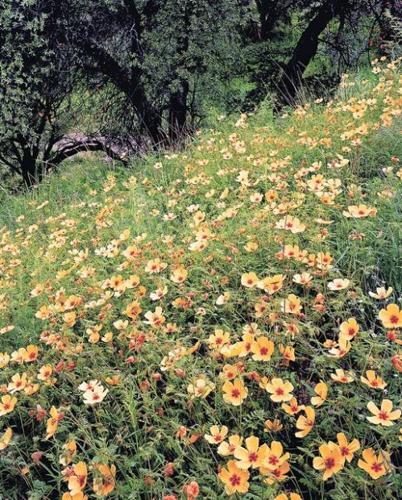
During another trip on an unseasonably cool monsoon day in August, Jack and I rumble into a wildflower paradise on Ruby Road, which starts as paved Arizona 289, heading west from Interstate 19 about 57 miles south of Tucson, then becomes unpaved Forest Service Road 39 that runs northwest past the closed ghost town of Ruby toward Arivaca.
Just a few miles into the drive, we're raving about the explosion of new green growth in the surrounding oak woodlands, transformed by torrential monsoons into something more out of the emerald mountains of Japan than the arid outback of Arizona. Then we round a bend and hit a mother lode of yellow — bright yellow caltrops, sometimes known as summer poppies, draping a blanket of color across a hillside. Around the next bend wait unfurled acres of wildflowers.
As Jack worries over a green glade of gnarly oaks, I jot these words in my notebook: "Be sure to bring a camera if you drive the highlands in the season of wildflowers. Your problem will not be what to shoot — but when to stop shooting."
A dot on the map says "Hell's Gate." Of course we wish to go there. We can only hope the rugged hike to Peck Canyon will not prove quite as daunting as the steep rocks and ice-plastered volcanoes we have climbed together in the past.
Relying on maps, signs and a special "sixth sense" that is wrong roughly 50 percent of the time, we somehow find our way to the starting point of the trek at an abandoned rancher's camp known as Corral Nuevo, thanks to a rugged four-wheel-drive vehicle to navigate the rough road leading from Ruby Road.
Near the dilapidated remains of an old windmill that harkens back to another era of ranching, we saddle ourselves with backpacks and slip into Peck Canyon.
Turns out we're not exactly Lewis and Clark. In the first mile of the canyon, we see signs of others who didn't just pop in for a night with flyweight camping gear and freeze-dried vittles — but who actually made a living here. Indian grinding holes mark streamside rocks, and segments of pipe left by ranchers building water projects rust in the canyon bottom. Makeshift trails suggest that border crossers also travel this terrain.
After an initial stretch of easy walking in a broad, sandy, dry watercourse, we find the canyon narrows dramatically and winds through a deep-cut chasm choked with enormous boulders. Heeding advice to skirt a narrow section that would force us to swim pools of water two miles in, we climb steeply out of the canyon and creep carefully along a narrow passage above a don't-slip-here drop-off.
"Good place to pay attention," Jack observes on a steep, unstable scramble back to the canyon bottom.
Once there, Jack goes to work photographing a lovely clear pool upon which delicate water shamrock plants float. Later, we hike to Hell's Gate, a spot less ominous than its name, where rock walls on either side of the canyon create a gatelike effect. We search for a flat campsite in this boulder-strewn landscape. Fortunately, years of backcountry travel have made us minimalists. We pull out bivouac sacks — little waterproof envelopes for our sleeping bags used in lieu of a tent. I set up a tiny gas stove on a rock and boil water to reconstitute our wonderfully light and perfectly tasteless freeze-dried dinners.
The last light of day leaks quickly out of the canyon and is replaced immediately by cold air plunging uninvited from above. We sit up jawing about the beauty of this place, the wild feel of it, although it's not more than 10 miles or so, as the crow flies, from Interstate 19.
Tomorrow we'll explore some more and discover new Tumacácori Highlands treasures. But now, before bidding each other good night and bedding down in our snug bivouac sacks, Jack and I can't help but wonder: Will Congress act soon on the proposal to protect this grand landscape as federal wilderness? Should it? Well, we're not legislators. We're not land-use experts. But we have wandered a lot of wilderness. We know it when we're in it. And tonight we are. Photos by Jack Dykinga / Courtesy of Arizona Highways
See Arizona Highways' June "Grand Canyon Guide"
To subscribe at up to 56 percent off newsstand price, go to www.arizona highways.com, select a subscription and type promo code TSN7.
IF YOU GO
• Location: Approximately 55 miles southwest of Tucson.
• Getting There: The most direct and scenic access is on Arizona 289, also known as Ruby Road. From Tucson, drive 55 miles south on Interstate 19 past Green Valley and Rio Rico to Arizona 289 at Exit 12. Follow paved 289 west toward Peña Blanca Lake for about nine miles to its intersection with unpaved Forest Service Road 39. To reach the trailhead for a hike to the Atascosa Lookout, continue west on FR 39 about five miles. The trailhead is on the right side of the road, 14.5 miles from the Interstate 19 exit, with parking on the left side of the road. To reach the Corral Nuevo trailhead into Hell's Gate, continue northwest on 39 for 6.4 miles past the Atascosa Lookout trailhead and watch for a 2.5-mile-long side road on the right marked "Hell's Gate." A high-clearance four-wheel-drive vehicle can cover the rough road leading to unsigned Corral Nuevo.
• Travel Advisory: Side roads off FR 39 range in condition from pretty rough to nearly impassable. Obey all closure signs. On side roads, use a four-wheel-drive vehicle in good condition and a second vehicle if possible.
• Warning: Federal officials have posted warnings concerning illegal immigration and smuggling in the area.
• Additional Information: Nogales Ranger District, Coronado National Forest, 1-520-281-2296. The Friends of the Tumacácori Highlands, www.tumacacoriwild.org.