
Explorer Francisco Vásquez de Coronado didn't have to obey the highway speed limit, make hotel reservations or fuss with other such travel details when he rode the route that now bears his name.
But chances are good that he saw much of the same splendid scenery during his journey — from 1540 to 1542 — that modern-day travelers enjoy on the Coronado Trail Scenic Byway.
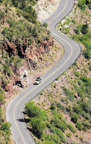
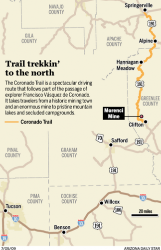
The 123-mile driving route — on U.S. 191 from Clifton to Springerville in eastern Arizona — generally traces a part of Coronado's passage through the Southwest. It winds past vast expanses of mountains, forests, meadows and rivers that have endured over the centuries.
It also leads to some sights that didn't yet exist when Coronado traveled in the area: small towns, a gargantuan open-pit mine, campgrounds, picnic sites and an idyllic mountain lodge.
People are also reading…
Driving the steep, curvy highway today makes for an adventurous weekend trip from Tucson. See the cover story inside for a guide to sights to see and places to stay.
It's not a spectacle you'll see in the deserts around Tucson: Bull elk — big ones, more than a dozen of them, sporting coats of buff brown and antlers the size of grand candelabras — strut across a green meadow nestled in a high mountain valley.
The scene, near the village of Alpine in eastern Arizona, is just one nugget in a trove of travel treasures along the Coronado Trail Scenic Byway.
The trail is a spectacular driving route that generally follows part of the passage of explorer Francisco Vásquez de Coronado on his expedition of 1540-42.
Spanning 123 miles of U.S. 191 from Clifton to Springerville, the paved highway climbs and snakes its way from a historic mining town and an enormous mine to pristine mountain lakes and secluded campgrounds.
The northern end of the route, at altitudes of more than 8,000 feet, offers a cooling interlude from the summer heat of the desert.
"This is just an awesome road to ride," said motorcyclist Steve Selleck, who traveled the trail recently with fellow rider Greg Deveraux. "We like to do the older, two-lane roads. This one is in pretty rugged and beautiful country."
One of the attractions of the Coronado Trail is that it takes drivers through vast expanses of sparsely populated terrain far from towns, gas stations, stores or other services.
One reason for caution on the Coronado Trail is that it takes drivers through vast expanses of sparsely populated terrain far from towns, gas stations, stores or other services.
The point of that bit of repetition: Be prepared. Make sure your vehicle is in good shape and has plenty of gas. Carry water, a picnic or snack foods, and basic emergency supplies. Don't count on cell-phone service.
You'll want to allow at least two days for a trip on the Coronado Trail — and a day or two more if you prefer a leisurely pace.
To reach the starting point of the trail in Clifton, you'll drive about 160 miles from Tucson. Take Interstate 10 east, past Benson and Willcox, to an exit for U.S. 191 heading north toward Safford. Drive to Safford and then continue on U.S. 191 northeast to Clifton.
If it seems like quite a bit of driving, just be grateful you're in a motor vehicle — and not traveling on horseback or foot like Coronado and his party.
Glance around this page for photos and brief descriptions of sights and suggested stops along the scenic byway.
Clifton
Perched on the banks of the San Francisco River in craggy mountain terrain, Clifton has deep roots in mining — from boom days to down times and an era of strikes and strife.
It's the county seat of Greenlee County and the home of some of the miners who work at a huge open-pit mine in nearby Morenci.
Pull off the highway into the Chase Creek Street historic district and you'll get a taste of what downtown was like in the boom days.
Many of the buildings are vacant now, but one of the old structures houses the popular Gold Panner Grub restaurant.
Owner Rick Workman shows off a small vial containing the fruits of his own panning efforts.
"There's about $5 worth of gold in here," he says with an ironic smile. "Tons of people piddle around with gold here. If you work really hard, you might make 20 bucks a day."
Workman says it's not the gold that keeps him and other loyal residents in town.
"This place reminds me of Bisbee 30 years ago — especially this street," he says. "Things are boarded up here, empty . . . but there's a river flowing right through town, with some really big catfish. There's all this history, too. And drive on up the highway and you're in pine trees in 20 minutes."
Among the historic buildings that attract tourists is the Clifton Town Jail, which is along the highway as it passes through town.
A solid, dreary stone structure, the jail is now open to tourists for a quick, self-guided sentence behind bars.
A sign outside offers this tidbit: "Tradition says that the first inmate in 1881 was the miner who built the jail."
And that's the thanks he gets.
Another attraction, frequently visible on the hillsides and even the streets of Clifton: bighorn sheep.
One day recently, several of the critters stopped traffic as they crossed U.S. 191 on the edge of town.
The Morenci Mine
Follow the Coronado Trail steeply uphill, past the town of Morenci, and you'll soon find yourself driving through a part of the enormous Morenci Mine.
The copper mine covers approximately 60,000 acres and is one of the largest open-pit mines in the world.
"What a view! That is one big pit," said Greg Deveraux, who stopped at a mine-overlook point on his Coronado Trail ride with fellow motorcyclist Steve Selleck.
The riders and other travelers at the overlook marveled at the almost incomprehensible scale of the mine, in which gargantuan trucks appeared almost toylike as they rumbled along deep in the pit.
The long and winding road
Steep grades, hairpin turns, wide-open spaces and far-horizon views are your immediate future when you leave the Morenci area and drive north on the serpentine highway.
Take it slow, pay close attention to the road and pull off for a rest break when you want to savor the vistas.
Consider a stop at the Chase Creek Scenic Vista between Mileposts 176 and 177. You might spot a natural rock arch in the distance far below.
Travelers equipped for camping could check out the Granville Campground, with picnic tables and campsites in a verdant opening in the woods. It's between Mileposts 178 and 179.
If you're up for some hiking, watch for signed trailheads all along the way — including one between Mileposts 179 and 180 and another between Mileposts 207 and 208.
Picnic with a view? Virgil Mena of Morenci found the perfect place — a picnic site and overlook at HL Saddle between Mileposts 182 and 183.
"This is a cool spot, huh?" Mena said as he munched his lunch at a table perched on a high point with bird's-eye views of distant canyons. "I like to come up here on my days off from the mine and bring something to eat."
After miles of twisting, turning and climbing, the Coronado Trail eases back and gives drivers a break. It passes through a vast, open, fairly flat expanse of grassland and meadow. In the stretch between Mileposts 193 and 194 you'll be in the midst of this easygoing part of the route, where it's not uncommon to spot wild turkeys along the highway.
After leaving the mesa terrain, the road returns to its old winding ways as it ascends into evergreen forests with abundant wildlife.
Watch for a turnoff for the Blue Vista Overlook between Mileposts 224 and 225. It's a good place to park, get out, take a short walk and gulp in views across forests, canyons and ridges that seem to extend ad infinitum.
Hannagan Meadow
Travelers, especially those who start their journey in desert regions, might feel as if they're about halfway to heaven when they reach 9,100-foot-high Hannagan Meadow.
The meadow itself is a comely expanse of high grasses flanked by evergreens and aspen trees. But the main destination for many visitors is the Hannagan Meadow Lodge near Milepost 232 on the highway.
Log cabins, rooms in the rustic lodge and a restaurant serving breakfast, lunch and dinner make the place a popular overnight stop for travelers from Tucson.
"It's just a beautiful area and a beautiful place to stay," said Lorrane McPherson of Tucson after dinner at the lodge with her husband, Bruce Fulton.
Richard Ayres, manager of the lodge, said the appeal of the area is elemental.
"It's the trees. It's the quiet. It's the solitude. It's the wildlife. What's not to like?" Ayres said while relaxing on the front porch. "We get visitors from all over the country and from places like New Zealand, France and Germany. That's part of the experience here — all the great people you meet."
Services at the lodge include a gas pump and a small store area with items for travelers.
For information and room rates, go online to www.hannaganmeadow.com or call 1-928-339-4370.
Happy camping
Just a short distance down the road from the lodge, in the direction of Clifton, is the Hannagan Campground.
Welcoming visitors to the free campsites this summer are campground hosts Don Williams and Doris Chardukian.
"We just love it up here," said Williams as the two sipped coffee beside a small campfire. "We like the weather, the quiet, the whole atmosphere."
The campground, on Apache-Sitgreaves National Forest land, has sites for tents, trailers and small recreational vehicles. Facilities include vault toilets, tables, fire rings with cooking grills and well water.
A lakeside interlude
Aker Lake, in a pristine alpine setting about three miles south of Hannagan Meadow, attracts anglers and those who just like to walk or relax in idyllic surroundings.
Anglers are limited to catch-and-release fishing using flies or lures.
An amble around the lake takes walkers through grassy meadows and along the edge of a forest of tall fir trees.
To reach the lake, watch for a turnoff onto a dirt road just north of Milepost 229 and follow the winding road to the lake.
Into the Alpine air
Some travelers from Tucson make Hannagan Meadow their turnaround point, but others follow the Coronado Trail 22 miles north to the village of Alpine and another 28 miles to Springerville.
Lodging is available in both towns — and chances are good you'll see elk, deer or other wildlife along the way.
Did you know
Mexican wolves, an endangered species, have been reintroduced on some national forest lands in eastern Arizona. People occasionally see wolves in the Hannagan Meadow area.