
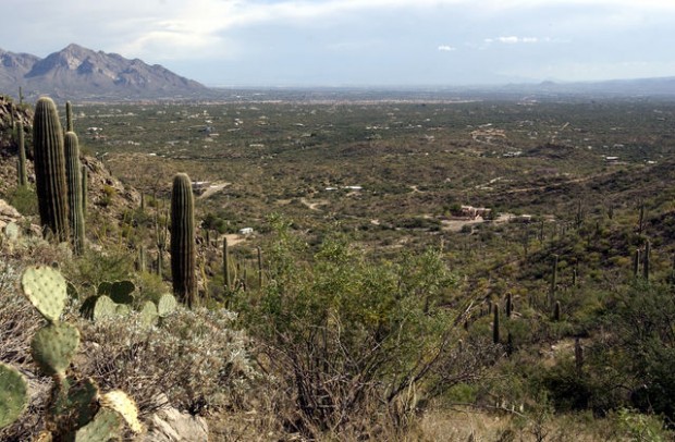
More than 20 years after establishing Tortolita Mountain Park, Pima County officials are finally moving forward with its master plan that someday could include close to 50,000 acres of wilderness stretching across two counties.
A public meeting was held Sept. 19 to solicit suggestions and ideas from people interested in what amenities the park will have, including trails and other recreational opportunities.
"We really appreciate having the input of a wide range of folks," said Steve Anderson, principal planner for Pima County's Parks and Recreation Department. "Our goal is to make the trails system the best it could be."
The Pima County Board of Supervisors adopted a master plan for Tortolita Mountain Park in 1997, identifying 21,030 acres that could eventually be part of the park. The existing park includes only 3,906 acres along the Pima/Pinal county line north of Marana and northwest of Oro Valley.
People are also reading…
"We have a plan that's 10 years old, and it's a good plan, but like any plan it needs to be updated," Parks and Recreation Director Rafael Payan said.
Anderson said most of the Tortolita Mountains lie in Pinal County, which has identified more than 27,000 acres it would like to see become a regional park. Pinal does not have a full-fledged parks and recreation department, though, so Pinal officials have allowed Pima County to take the lead in planning for the overall mountain park.
"We have an intergovernmental agreement with Pima County in terms of planning and development of the park," said Kent Taylor, senior planner of Pinal's Open Space and Trails Master Plan. "We want to make sure we're providing for the opportunity to protect the Tortolita Mountain range as it's being protected on the other side of the county line."
Though plenty of rough trails traverse the park, only 15 miles' worth of official trails — built by Marana on the southwest side of the park — exist.
Anderson said his department has identified five main access points to the park, none of them in current park boundaries. The Cochie Canyon and Wild Burro trailheads are on the southwest side of the master-plan area, while the Vulture Peak and Oro Valley trailheads are on the southeast side. The Crow Wash trailhead lies on the northeast side just below the Pinal/Pima line.
Much of the area around these proposed trailheads is state trust land, which Anderson says he hopes the county can someday acquire to expand the park to its desired size.
"Access is obviously a critical issue, so we'll do our best to provide high-quality access to the park," Anderson said.
But property owners near the southeast corner of the park question whether Pima County is really trying to provide the best access, based on their claims that the county is allowing a developer to block one of the routes into the park.
The proposed site for the 2.2-acre Vulture Peak trailhead is to be built by the developer of Saguaro Ranch, a luxury, gated community being built just inside Marana's easternmost boundary, as part of a 2003 pre-annexation agreement.
As part of the agreement, Pima County would abandon access to an easement leading into Tortolita Mountain Park in exchange for Saguaro Ranch gaining right-of-way access on state trust land between the trailhead and the park.
Approval of the final plat of Saguaro Ranch's Phase III was pulled from the Marana Town Council's Sept. 18 consent agenda, at the request of Pima County Administrator Chuck Huckelberry. In a letter dated June 22 to the Marana council, Huckelberry said he'd like to see approval of that plat held off until "the trail has been constructed and legally dedicated."
Joe Tarver, a lawyer who represents Saguaro Ranch, said the trail route has been approved by the county and all that has to be done is "a little paperwork to finish up with the county, just memorializing the agreement." He said he expects the final plat to be back on the Marana council agenda as soon as Tuesday.
The 1.4-mile route connecting the trailhead to Tortolita Mountain Park would make it impossible for senior citizens and those with disabilities to enjoy the park from that entrance, said Mark Van Ert, whose home is less than a half-mile from Saguaro Ranch.
"I still hope the county would take the best interest of the public and should exercise an interest in pursuing that existing easement so as to allow vehicular access to the park," Van Ert said.
Huckelberry said the easement in question is intended as a secondary access to the park, and the traffic on that trail would be light. "We'd like to have as many secondary access points as possible," he said.
The written comments submitted by the 60 or 70 people who attended the public meeting will be used by Pima County parks and recreation officials to generate data for mapping of possible trails, Anderson said. Following some field work, another public meeting will be scheduled sometime in the next few months.
Tortolita Park timeline
• 1986-88: Pima County purchases 3,056 acres along its northern boundary, establishing Tortolita Mountain Park.
• 1997: The Pima County Board of Supervisors approves the Tortolita Mountain Park Master Plan, identifying 21,030 acres that could eventually be part of the park.
• 1996-2005: Pima County buys an additional 850 acres, using funds from 1997 and 2004 bond elections, bringing the total size of Tortolita Mountain Park to 3,906 acres.
• 2007: Pinal County releases its Open Space and Trails Master Plan, identifying 27,413 acres in the Tortolita Mountains for a possible regional park.