The record-breaking heat in this month's forecast is likely to help push the Colorado River Basin to the edge of "disaster," in which drastic cuts in water use will be necessary next year, experts say.
The heat is almost certain to slash river flows even more than already expected after the snowpack in key sites above Lake Powell hit record lows this winter. The upshot: Lake Powell is likely to get less than one-third the water from the river that it would in an average April to July.
The unusually low flows won't be bad enough to push the basin into immediate disaster this year. But several experts said it is virtually inevitable that major cuts in river water use will be needed next year in Arizona and other Western states — unless the winter of 2026-27 is far cooler and wetter than the current one.
People are also reading…
"We can survive this year, no problem. What'll be interesting to see is if this year puts enough scare into the states to begin real serious rethinking about how we manage water," said David Wegner, a retired U.S. Bureau of Reclamation planner and congressional staffer who now sits on a National Academy of Sciences board that reviews water issues.

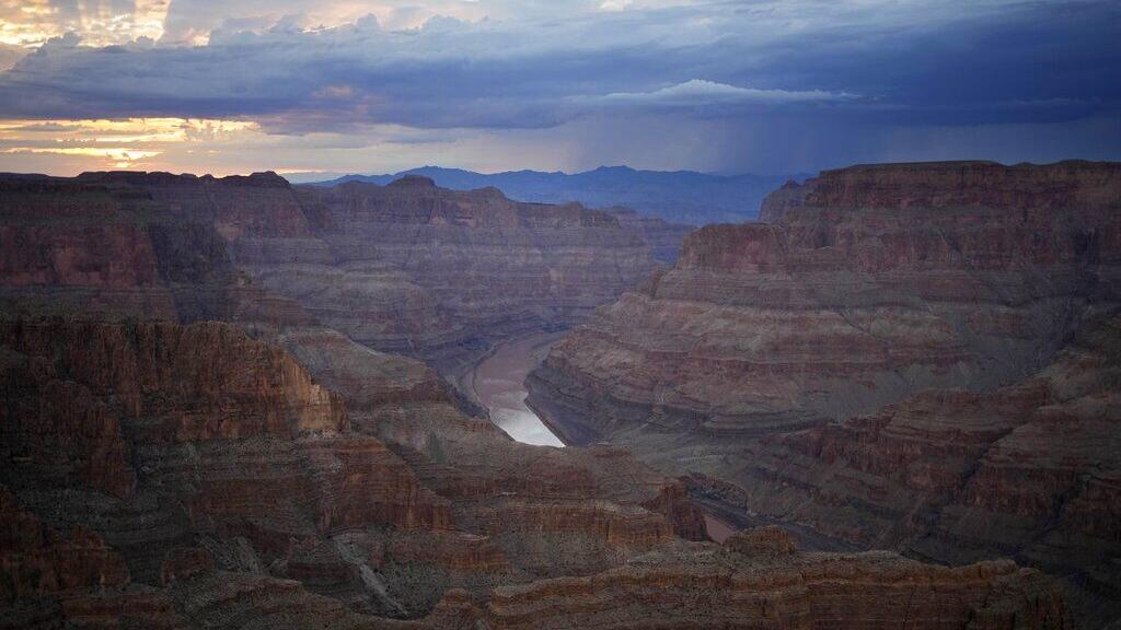
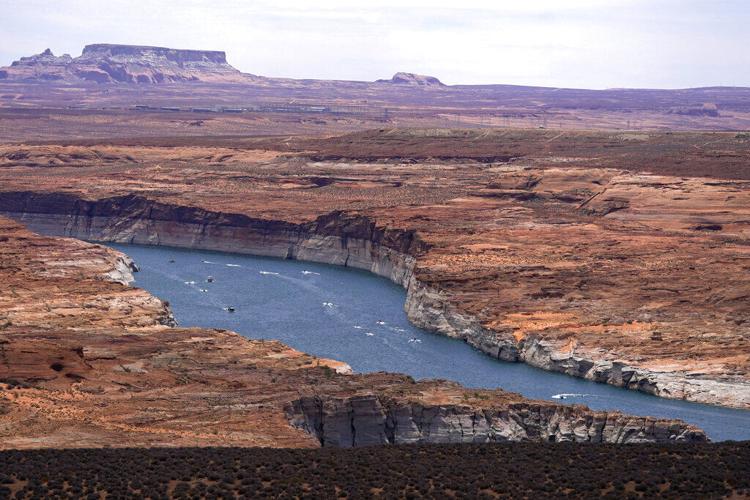
Shrunken waters are shown in a portion of the Colorado River's Lake Powell reservoir near Page, Arizona, in 2022.
"We're not in a disaster yet, but we're on the cusp of it," said Eric Kuhn, an author and water researcher.
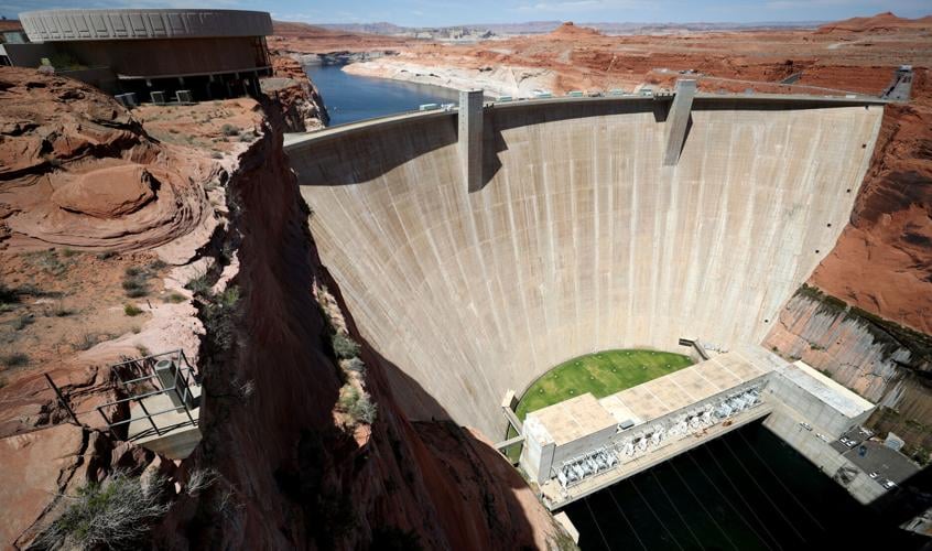
The Bureau of Reclamation already projected, in February, that Lake Powell is likely to fall below the level at which the turbines at adjoining Glen Canyon Dam can generate electricity — 3,490 feet — by December 2026.
Given the trend toward lower snowpack, higher temperatures and less runoff of water into the river, it's very possible if not likely, that future forecasts will show the lake falling below 3,490 feet sooner than December.
But most observers, including Kuhn and Wegner expect the bureau to try to forestall that possibility in advance by releasing extra water from reservoirs upstream of Lake Powell, led by Flaming Gorge reservoir at the Utah-Wyoming border. Powell is at the Arizona-Utah border.
Water releases downstream
How much water is released is likely to be a matter of controversy, however. The Lower Colorado River Basin states of California, Arizona and Nevada want more water released from upstream reservoirs into Powell. They argue those reservoirs were initially approved in the 1950s to store enough extra water to ensure the Upper Basin states can meet required obligations to deliver water to Lake Mead. Mead, at the Arizona-Nevada border, stores water for delivery to the Lower Basin states for drinking and irrigation.
The Lower Basin's argument is disputed by the Upper Basin states of Colorado, Utah, New Mexico and Wyoming.
"Their contention is those other reservoirs were built to satisfy their needs," Wegner said.
What's clear is that if river flows drop as low as some experts fear, there will definitely be less water coming to Arizona, California and Nevada from Lake Mead.

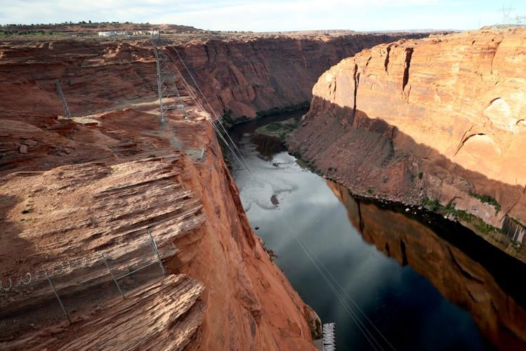
The Colorado River below Glen Canyon Dam near Page, Arizona.
"Once that water gets to Lake Powell, the Upper Basin doesn’t have any access to it any more. This is a point of contention between the Upper and Lower basins. This is one of the sticking points in their ongoing negotiations over managing the river," Wegner said.
Arizona: 15% less river water next year?
At the start of 2026, the seven basin states and the Bureau of Reclamation were projecting that up to 7.48 million acre-feet of water would flow downstream from Lake Powell to Lake Mead.
Now, however, the expected hot, dry weather could cut the release to as low as 6 million acre-feet, the minimum release allowable under current federal guidelines and rules, Kuhn said. Six-million acre-feet amounts to a little more than six years' worth of Colorado River water deliveries to Arizona by the Central Arizona Project canal system.
Under such a low release, Arizona might be forced to take 15% less river water next year than it is now, experts said. A shortage of that scale wouldn't affect Tucson's river water supply but would cut supplies to some tribes and some Phoenix-area cities.
Flaw in forecasting system
Another factor that could result in river flows being significantly lower than expected is that, according to some critics, the federal Colorado Basin River Forecast Center relies on flawed assumptions in making its forecasts.
The assumptions include the use of unusually wet years in the 1990s as a partial basis for forecasting and not using the very dry period of 2021-25 as a basis for forecasts, said Alan Boyce, a farmer who tracks river flows and forecasts closely from his farmland in the Yuma area and in California's Imperial Valley.
On March 1, the federal river forecast renter projected that Powell would get 36% of its average April-July flows from the mountains upstream — commonly known as runoff. If that forecast proves correct, it would be the third-lowest April-July flow into Powell since the reservoir started filling in the 1960s.

Glen Canyon Dam, which creates Lake Powell on the Colorado River.
But now, National Weather Service forecasters predict that a huge high-pressure ridge, known as a heat dome, will push temperatures across the Rocky Mountain West and California to record levels for much of the coming week.
Upcoming extreme heat
In Tucson and Phoenix, the high pressure is expected to push daytime highs over 100 degrees for at least three days starting Thursday. Until now, the earliest Tucson's temperature has reached 100, in records going back to 1895, was April 11. In Denver, temperatures are expected to hit the 80s late next week, far above seasonal averages.
"I think it is plausible that this upcoming extreme and in some cases record-breaking (to even record-shattering, meaning breaking longstanding records by wide margins) heatwave could further worsen the Colorado River crisis beyond what is currently predicted," Daniel Swain, an independent climate scientist in California, wrote in an email to the Star.
Extreme heat can reduce river flows in a number of ways. Commonly, it increases evaporation of water in the river. Combined with extremely dry weather, it can also force soils, trees and other vegetation to suck up most or all of the available moisture, leaving little to run into rivers and streams, said Wegner.
"We're already seeing willows here leafing out and other things starting to sprout," he said. Leaves in Tucson are already taking in and evaporating water into the air, he said. "As the trees get stressed they suck up more water," Wegner said.
Also, the hot early-season weather prematurely melts snowpack earlier in the year, reducing spring-summer flows into the river, even though total snowmelt may be about the same, Swain said.
A final factor is the lesser-known influence of sublimation, in which high winds, low humidity, warmer air and strong sunlight cause snowbanks to be converted directly into water vapor without ever becoming liquid.

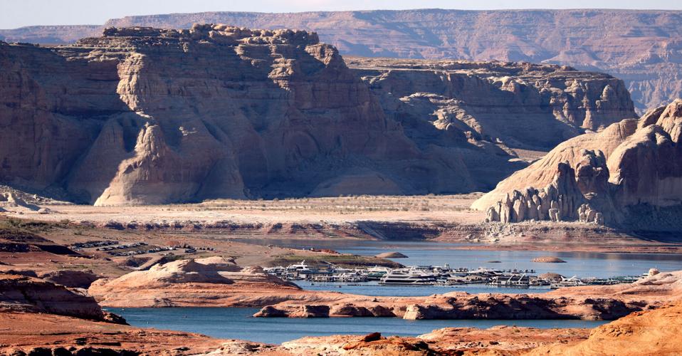
Boats move along Lake Powell near Wahweap, Arizona.
Drier years since 2021
Boyce noted that the river forecast center today uses the 30-year period from 1991 through 2020 as a partial basis for its monthly forecasts of spring-summer river flows. But the center ignores the period starting in 2021 in which river flows generally have been far drier than normal, he said.
He also said the forecast center ignores longer-term National Weather Service forecasts — stretching longer than 7 days — when it makes its river flow forecasts.
"They ignored this very valuable info that would have said there’s going to be a lot less runoff" than the center's March forecast had predicted, Boyce said.
Cody Moser, a river forecast center official, said the center hopes to start, as early as 2027, relying more on the 2021-25 weather patterns to make its future forecasts.
"Using the more recent 2021-2025 period to generate flow scenarios will be beneficial, especially in drier years since most years since 2020 have been drier than normal, and this would be reflected in our future flow possibilities," he said.
As for the center's use of National Weather Service forecasts, Moser acknowledged that the center has less confidence in longer-range forecasts stretching past 14 days, so historically hasn't used them as a factor in its water supply forecasts.
"With that said, we are working on ways to incorporate longer-term weather outlooks as those forecasts are starting to show more skill/accuracy," said Moser, a senior hydrologist for the river forecast center.
The prospect of dramatically reduced river flows into Lake Powell comes as the seven river basin states are locked in a seemingly intractable dispute over who should take the cuts necessary to balance demands for river water with its dwindling supply. After two years of negotiations, the states' leaders have been unable to come up with a compromise settlement over how the river and its reservoirs should be managed.
The four Upper Basin states have refused to agree to take any mandatory water use cuts, arguing that the Lower Basin states should take all the cuts because they use more than their legal share of the river's supply, whereas the Upper Basin states use less than their share. The Lower Basin states, which have far more people and a much bigger economy than the Upper Basin, say it's not fair to ask them to bear the burden by themselves of trimming overuse of the river.
The federal government is likely to have to step in with its own water-saving plan, which in turn is likely to trigger litigation from representatives of one or both basins.
How the expected lower river flows will affect the negotiations is anybody's guess. But it's hard to imagine the disputes getting easier to settle.
Longtime Arizona Daily Star reporter Tony Davis shares how he came to focus on coverage of the Colorado River as an environmental reporter.
Contact Tony Davis at 520-349-0350 or tdavis@tucson.com. Follow Davis on Twitter@tonydavis987.

Tony Davis
Reporter