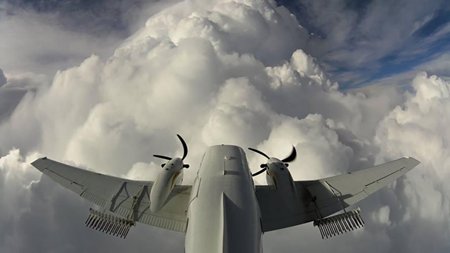

An aircraft flies into the clouds carrying flares filled with silver iodide being released to help make more snow.
(CNN) — With 61% of the contiguous US in drought, wouldn't it be nice if we could just "make it rain" or just "make more snow?"
Well, certain parts of the country are doing just that, sort of. It's called cloud seeding, and it's nothing new.
It's been around since the 1940s, and countries all over the world have been doing it for various reasons (most notably China), but it's a growing practice in the U.S., especially in the drought-stricken West.
It's also surrounded with controversy.
We spoke with Julie Gondzar, who is the program manager for Wyoming's Weather Modification Program, who admits she gets lots of calls about what they are doing.
People are also reading…
Gondzar said some people say "you're playing God," others say "you are stealing moisture from the storm," making other areas drier than they normally would be, kind of like robbing Peter to pay Paul.
"Think about it like water storage, but in the winter on mountaintops," is how Gondzar described what cloud seeding is trying to achieve in her state, "in a nutshell."
Wyoming started cloud seeding in 2003 as part of a study. Then eight seasons ago, the state started doing it in an official capacity after a 10-year study proved it works.
This season, they have gone on 28 flight missions for cloud seeding in Wyoming.
She pointed out there are four weeks left in the season, so she is hoping for more opportunities before it winds down.
When you compare Wyoming to other states like Utah and North Dakota, which have been cloud seeding since the '70s and '80s, the state is fairly new to the game.

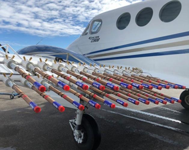
This photo shows flares fixed on the aircraft's wing with silver iodide used for cloud seeding.
Cloud seeding uses an already existing cloud and injects silver iodide into the cloud, which adds tiny particles called ice nuclei (which water needs to freeze). Clouds, in basic terms, are a collection of water droplets and/or ice crystals floating in the sky. The nuclei help the cloud produce precipitation, and artificial ice nuclei help create more precipitation than the cloud would produce otherwise.
It's done in two ways: One way is from the ground, and the other is from the air, using silver iodide as the seeding agent.
"The ground-based generators kind of look like small weather stations, are like 20 feet tall, and they aerosolize into the atmosphere," Gondzar explained. "But you have to wait for the right atmospheric conditions so that the plume goes over the mountain range." It makes seeding a little more tricky, because if the wind is blowing in the wrong direction, you'll completely miss your target.
The most popular way is by plane, using flares. "There are flares on the wing of the planes with silver iodide inside of cardboard casings, and there are flares on the belly of the plane," Gondzar pointed out.
Once the pilot flies into the storm, cardboard casings full of silver iodide are ignited to "seed" the clouds. The result is more moisture in the cloud, resulting in more precipitation.
The silver iodide "is a natural salt compound," Gondzar emphasized. "The reason it's used is because the geometric shape down to a molecular level is very similar to that of an ice crystal. And if you don't have that, you're not going to create additional ice crystals, which will then accumulate into snowflakes."
But if you think you can bust the drought by using planes to modify the weather, Gondzar said, think again.
Is it working?
"Cloud seeding does not fix the drought," Gondzar acknowledged. "You can't break a drought with cloud seeding. It's a tool in the toolbox."
Gondzar admitted while they know the method makes more snow than they would otherwise receive, it's difficult to know exactly how much more they are getting.
"There's evidence of it in radar and all kinds of papers written," Gondzar noted. "The question that they're trying to answer now is how well does it work? And that's a difficult question to answer. Because there's an abstract piece of this. There's really no way to know how much snow a particular system would have produced."
She knows cloud seeding doesn't generate a lot of additional snowfall, but every little bit helps these days.
According to Wyoming's Water Systems Data Map, some areas in the state are only at 60% of average for snowpack this season, and the window for additional snow is slowly closing as the season winds down.
Since most of the West gets the majority of its water from snowmelt, she hopes what they are doing helps a tiny bit in the long-term.
"It's a small incremental change over a long period of time. That's why consistency is important," Gondzar urged.
departure from average precipitation
Photos: Megadrought in US West hits worst-case scenario

A kayaker paddles in Lake Oroville as water levels remain low due to continuing drought conditions in Oroville, Calif., on Aug. 22, 2021. The American West's megadrought deepened so much last year that it is now the driest it has been in at least 1,200 years and a worst-case scenario playing out live, a new study finds.

Matt Lisignoli walks through an irrigation canal that ran dry in early August after the North Unit Irrigation District exhausted its allocated water on Sept. 1, 2021, near Madras, Ore.

A buoy once used to warn of a submerged rock rests on the ground along the waterline near a closed boat ramp on Lake Mead at the Lake Mead National Recreation Area, Aug. 13, 2021, near Boulder City, Nev.

A car crosses Enterprise Bridge over Lake Oroville's dry banks on May 23, 2021, in Oroville, Calif.