

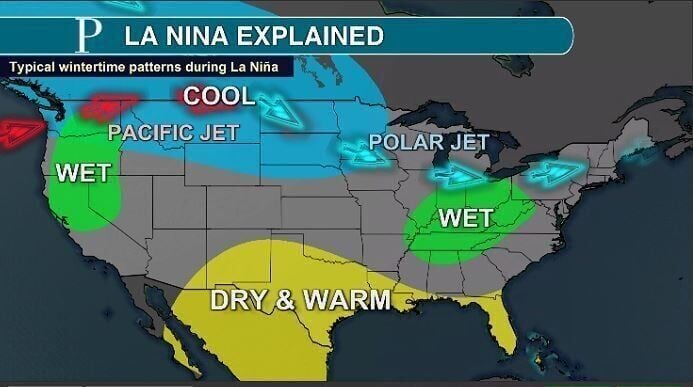
Three winters in a row, La Niña conditions brought everything from a record snowless season to multiple blizzards across the state.
This year, however, El Niño is back for the first time since before the COVID-19 pandemic and will influence our weather across New Jersey.

Three winters in a row, La Niña conditions brought everything from a record snowless season to multiple blizzards across the state. However, El Niño is back for the first since before the COVID-19 pandemic, and will try to influence our temperatures.
Judah Cohen, director of seasonal forecasts for Verisk Atmospheric and Environmental Research, said this winter will be “mild or wild.”
Cohen said the El Niño weather pattern will load the dice to bring numerous storms to the Southeast and Mid-Atlantic, where New Jersey is. However, enough cold air will need to link up with those storms to actually bring snow. The winter as a whole is favored to have more seasonable or warmer than average days than colder than average ones.
People are also reading…
The times most favored for snow and below average cold would be in December. Later February or March could also bring such a stretch.
“It could be a sandwich of sorts. ... We had this winter bookend where it was active from a winter (weather) standpoint in the beginning and end and then, in the middle, nothing went on,” Cohen said.
Cohen cites the winters of 2009-10 and 2017-18 as possible examples of what this winter in New Jersey could be like. Both of those winters featured a December with a long cold stretch, a snowstorm or both as the polar vortex entered the region.
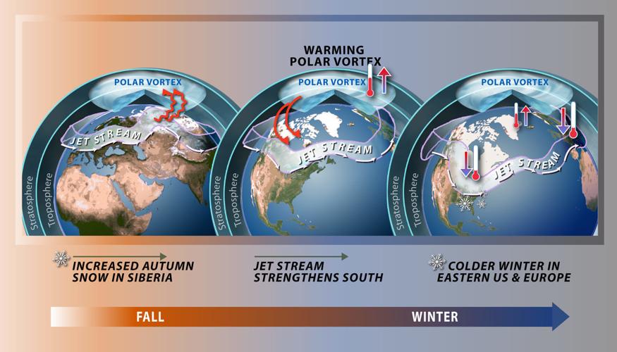
The polar vortex is a low-pressure system that houses the most significant cold on Earth. The vortex likes to spin atop the North Pole. Sometimes, though, it stretches or splits, drifting into the Northeast.
In winter 2009-10, February saw well above average snowfall from multiple storms, with well below average temperatures. In winter 2017-18, four nor’easters hit the state in March.
Many schools closed Wednesday, coastal residents moved cars to high ground to avoid flooding, and road crews salted and plowed through the fourth nor’easter to hit the region this month.
The “wild or mild” winter Cohen predicts is different from the past three winters. The reason mainly has to do with El Niño
El Niño (Spanish for “little boy”) is one of three phases of the El Niño Southern Oscillation. There also is La Niña (“little girl”) and a neutral state. New Jersey was in La Niña the previous three years, which contributed to the record low snowfall seen in parts of the state last winter.
What phase the globe is in is based on how Pacific Ocean temperatures off South America near the equator are faring compared to average. Warmer than average water means El Niño, cooler than average brings La Niña and near seasonable water temperatures bring the neutral phase.
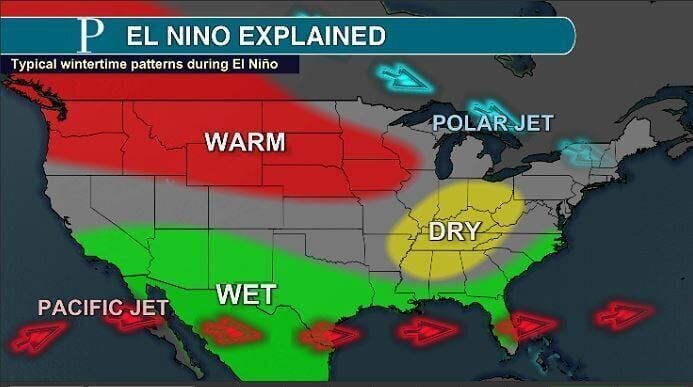
The state of the El Niño Southern Oscillation is one of if not the main factor seasonal forecasters use to predict the upcoming winter. However, its influence on New Jersey is generally limited.
El Niño promotes a strong subtropical jet stream. The river of air roughly 30,000 feet above the ground that separates two airmasses can be seen as the storm track.
The warm, moisture-laden weather this type of jet stream brings will be persistent in the southern tier of the United States.
Then there’s the polar jet stream, which separates the polar vortex from more seasonable temperatures. In an El Niño, this jet stream will move out of Western Canada toward the Great Lakes. From there, its path is hard to forecast. Sometimes, it’ll stay in New England, keeping New Jersey seasonable to milder than average. Sometimes, it’ll move to the Mid-Atlantic, bringing the outer edge of the frigid polar vortex into the state.
If the polar jet stream moves into the Mid-Atlantic, it can link up with the moist subtropical jet stream and develop nor’easters. That would give most of New Jersey accumulating snow, potentially heavy snow.
This winter will likely be a strong El Niño. Going back in history, strong El Niños typically saw few days with snow. However, when it snowed, it accounted for the vast majority of that season’s totals for New Jersey.
Average snowfall totals range from about 15 inches toward Cape May to around 50 inches in the highest peaks in northwestern New Jersey.
However, two snows can bring as much or more than the average. Another way of understanding seasonal snowfall in New Jersey is by looking at the average number of times snow accumulates. This ranges from around five days in Cape May to over a dozen days in places like Newark and Sussex.
Cohen and other forecasters say other factors will be at play this winter.
The Quasi-Biennial Oscillation is a wind roughly 60,000 feet above the surface that flows around the equator. This winter, flow is expected to run east to west, known as the negative phase.
“A negative QBO regime tends to support the transport of polar and Arctic air masses toward the mid-latitudes of North America and Europe more often in the winter,” Steve DiMartino, owner of NY NJ PA Weather in Freehold, Monmouth County, said in his winter outlook.
That adds confidence for at least one big winter storm in the state.
Snow cover halfway around the world, in Siberia, will also play a role this winter.
In recent years, Cohen has focused on how quickly October snow accumulated in Siberia. The more rapid increase in snowfall cover there, the more likely for snow and cold in the Northeast.
“It was a very slow start (to October), but if there was a redeeming part, it was the last week of October,” Cohen said about the quick downfall of snow to wrap up the month.

Increased Autumn snow typically has led to increased storminess in the Northeast. Cohen has led the research effort on this. However, he does claim that the relationship has weakened in recent years.
Cohen said the likelihood of average snowfall will be low. Either the subtropical and polar jet streams will link up for a few snowstorms, or they miss each other, leaving New Jersey less snowy than average again.
Taking into account all days between December and March, temperatures will likely be above average.


