Arizona, California and Nevada say they've put together a proposal to stabilize the ailing Colorado River by saving at least 3.2 million acre-feet of water through 2028.
That's the equivalent of enough water to serve Tucson for 32 years.
The proposal was announced Friday evening in a news release from the three states as an attempt to stabilize the river over the next few years.
The Star obtained a copy of the proposal itself, sent to the U.S. Interior Department. It was accompanied by a letter to Interior officials written by the three states' top water officials, including Arizona Department of Water Resources Director Tom Buschatzke.
"The objective of this proposal is to build resilience in the Colorado River system and provide a bridge to long-term operations. The Lower Division States remain committed to constructive engagement with the Department and all Basin partners to achieve a sustainable and legally sound path forward," wrote Buschatzke, Southern Nevada Water Authority General Manager John Entsminger and California's Colorado River Commissioner J.B. Hamby.
People are also reading…
The new proposal pledges to conserve 700,000 to 1 million acre-feet of river water by the end of 2028. That would be on top of 1.25 million acre-feet a year that the three states had already pledged to conserve in an earlier proposal.
The states' long-term goal is to create a common pool of new water savings to be strategically deployed at times of low reservoir elevations to help delay and offset additional reductions to the Lower Colorado River Basin states of Arizona, California and Nevada that are needed beyond the earlier plan for saving 1.25 million acre-feet yearly, the new proposal says.
The news release was short on details of which water users in the states would bear the brunt of any new conservation measures. But the proposal does anticipate splitting the first 700,000 acre-feet in savings, with Arizona and California each taking cuts of 300,000 acre-feet and Nevada giving up 100,000 acre-feet.
The Lower Basin states and the U.S. Bureau of Reclamation expect to develop a plan by August 2026 to identify specific contributions, the proposal says.
"With inflow to Lake Powell trending toward record lows and exacerbating the near-term risk of breaching critical elevations at Lake Powell and Lake Mead, quick and decisive action is urgently required. The Lower Basin proposal provides just that. ... It is an ambitious and far-reaching plan that benefits the entire Colorado River Basin and requires the continued leadership of the Department of Interior in partnering with the Lower Basin states to bring its benefits to fruition," the state leaders wrote to Assistant Interior Secretary Andrea Travnicek.

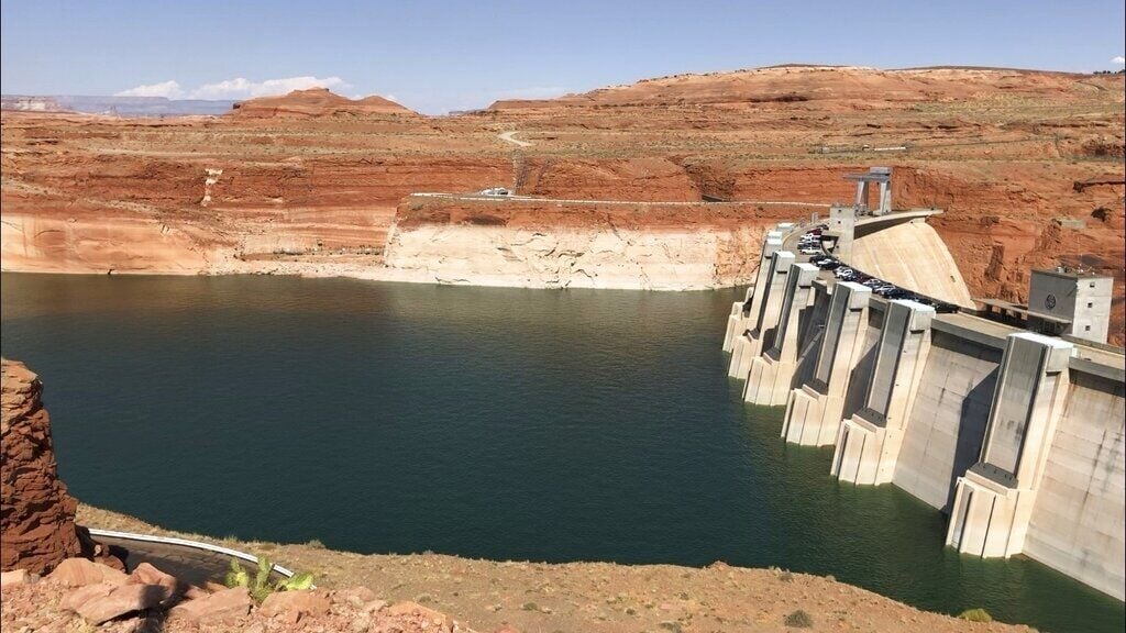
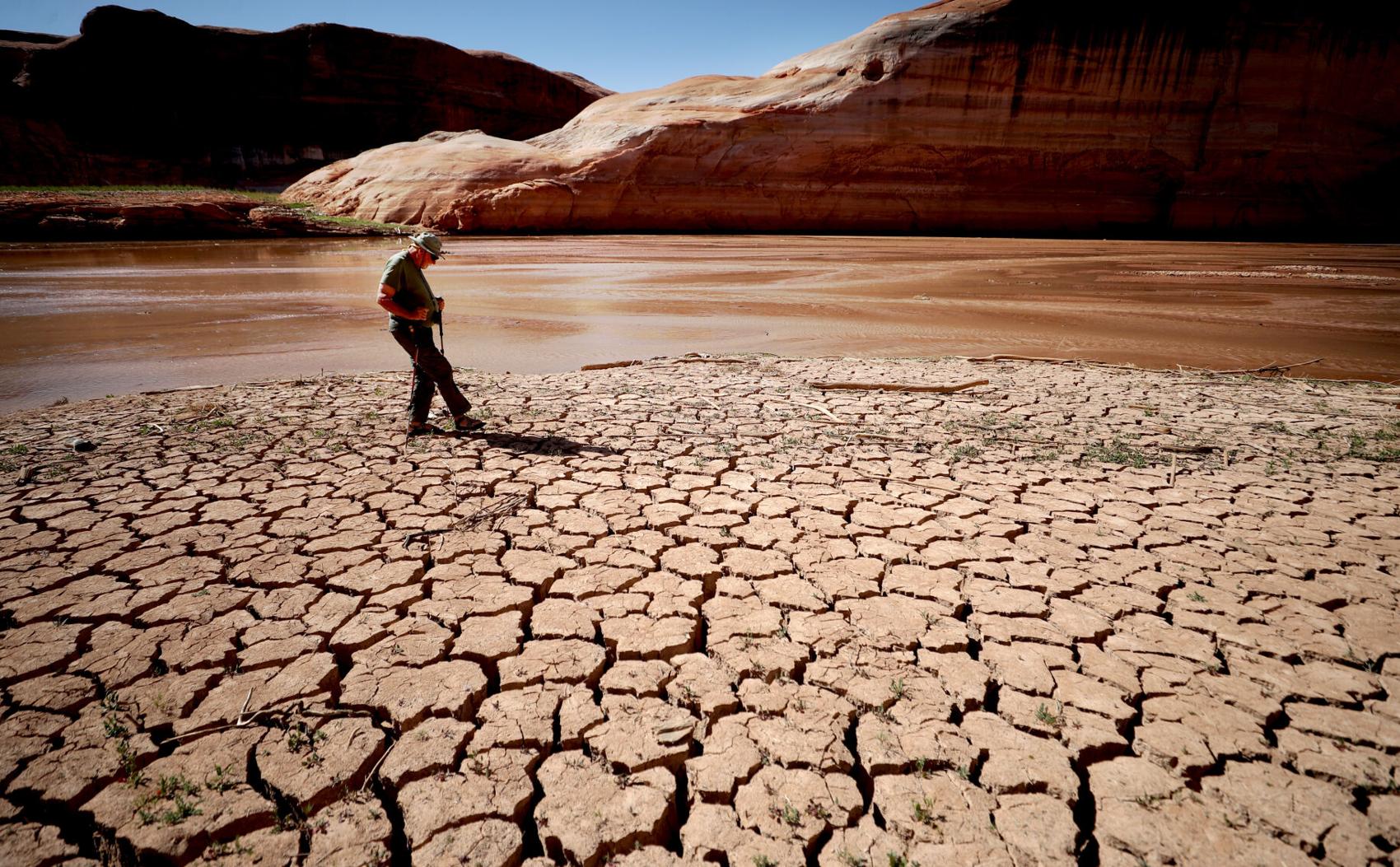
Shrunken waters are shown in a portion of the Colorado River's Lake Powell reservoir near Page, Arizona, in 2022.
Would create a pool for tribal use
The water conservation proposal by the Lower Basin states is combined with a raft of other proposals and ideas, covering a wide range of issues.
Perhaps the most noteworthy of the other proposals calls for creation of a "tribal pool" of water that would be set aside in Lake Mead for use by Arizona tribes. It would try to ensure that during shortages, tribes get the water they were guaranteed in past court settlements and other agreements with the feds.
Under the new proposal, furnishing water to the pool would be mainly a federal responsibility, although Arizona tribes would also contribute to it.
Lower Basin states would not contribute to the pool, which is anticipated to be "of a magnitude" of 280,000 acre-feet in size, the new proposal says.
The proposal comes as officials in all seven river basin states deal with twin crises on the river. One is the need to come up with a new, long-term plan to manage the river and its reservoirs over the next 20 years by approving ways to balance water use with supply from a long-depleted river.
The other is a short-term crisis, triggered by a recent surge of extraordinarily warm, dry weather that has lowered current river flows to the point that the functions of Lake Powell and Lake Mead are facing immediate disruption.
Just last month, the Bureau of Reclamation announced it would cut river water releases from Lake Powell to Lake Mead by 20% this year — reductions that could mean immediate or near-term cuts in water deliveries to Arizona, Nevada and California.
In recent years, the river has been running at about a 3 million acre-foot deficit annually between water use and supplies. To put that in perspective, the Central Arizona Project canal system had been delivering at least 1 million acre-feet of water to Tucson, Phoenix and other Arizona cities and farms until the last few years, although the project now delivers about 800,000 to 900,000 acre-feet a year.
This new proposal also comes as the Lower Basin states are locked in a prolonged stalemate with the river's Upper Basin states of Colorado, New Mexico, Utah and Wyoming over how to curb long-term water overuse.
The news release says the Lower Basin states are "open" to a recent proposal from the Upper Basin states to bring in an outside mediator to try to resolve their differences.

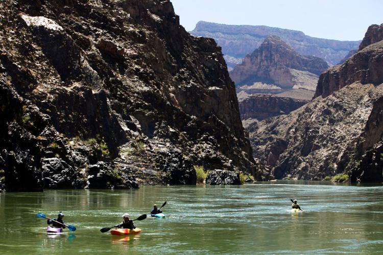
The Colorado River in Grand Canyon National Park.
"The Lower Basin states stand ready to engage in a meaningful process for long-term solutions while encouraging the Upper Basin to step forward now with verifiable water contributions to help stabilize the system and support a near-term, seven state bridge," the news release said.
So far, however, the Upper Basin states have resisted calls from Lower Basin states to take any mandatory conservation actions and have proposed only voluntary measures. Those states say their water users already face routine, regular shortages when dry weather reduces flows in Colorado River tributaries they depend on.
'Will benefit the entire basin'
The stalemate has raised the very real possibility of litigation over the river that could last years.
But the Lower Basin states' proposal says, "While the prospect of litigation necessarily remains in the absence of a 7-state agreement, the proposal described below will benefit the entire basin through the substantial water savings and the voluntary commitments that would be made in the agreements required for implementation.
"We hope these actions can provide additional time to develop a longer-term approach involving actions to achieve reductions in use by all seven states when the system demands it, which would limit or eliminate the prospect of interstate litigation and provide Reclamation with the fullest set of tools and resources to effectively manage the system," the proposal says.
The new proposal is an "integrated package" addressing a range of existing Colorado River issues, the news release said. It's been sent to the federal government as it prepares its own 20-year plan for the river after the Upper and Lower Basin states failed to reach a compromise agreement on how water savings can be achieved.
The new plan is intended to be a "near-term" bridge through 2028, while the feds finalize their long-term operating guidelines for the river, the news release said. Many basin state officials have already acknowledged that achieving a compromise for a long-range conservation plan is impossible before the river's current operating guidelines expire on Sept. 30, 2026.
Some officials have already talked of trying to put together a shorter-term plan to stabilize the river until a long-term plan can be adopted.
The proposal includes ideas for addressing releases from Lake Powell to Lake Mead, Lower Basin water use reductions, additional conservation, use of water already stored in Lake Mead, and what it calls "system infrastructure improvements."
The state leaders' letter to Interior's Travnicek made it clear that this proposal is a whole — not just a series of independent parts — and must be treated that way by the feds.
"The proposal is structured as a unified package. Its components are not independent and should not be evaluated or modified in isolation."
The proposal's operational elements governing Lake Powell releases, use of reservoirs lying upstream of Powell and proposed Lower Basin conservation contributions and the use of reservoirs upstream of Powell are foundational, as the Lower Basin reductions and proposed contributions are directly dependent on them, the water leaders wrote.
Requires 'federal partnership'
As federal laws and regulations dictate, Interior doesn't have authority to implement Lower Basin water use reductions or conservation activities, or the separate proposal setting aside a pool of water specifically for Arizona tribal users, without the Lower Basin states' approval, the state leaders wrote.
The Lower Basin's contributions to conservation also depend on approving a package of coordinated operations as well as additional funding "at a sufficient scale," the state water leaders wrote. Implementing this program will require "federal partnership," and must be approved by the Arizona Legislature and water governing boards in Nevada and California, the news release said.
The Lower Basin states anticipate setting up a cost-sharing arrangement with the feds to provide the needed funds, the state leaders wrote.
Past water conservation efforts in the Lower Basin in the current decade have been greased by a massive influx of federal money paid to cities, farms and tribes in exchange for water savings.
The proposal would also allow an extension of its terms past 2027 for a year or longer, if additional federal funds to put it into effect are available by the end of 2027.
Finally, the proposal makes it clear that the three Lower Basin states aren't waiving their right to sue to protect their water rights if necessary if the proposal is adopted.
The Lower Basin states and water users "have prepared this proposal on a voluntary and non-precedential basis, to address the dire hydrologic conditions affecting the Colorado River system," the proposal says. "Nothing in this proposal, including any party’s participation or the magnitude or form of any party’s contributions, shall be construed as a waiver, relinquishment, or modification of any party’s rights, claims, or defenses under the Law of the River, all of which are expressly reserved."
The Law of the River is a package of laws, regulations, court precedents and other rulings that provide a legal framework for managing the Colorado River.
In the states' news release, ADWR's Buschatzke said, "This proposal reflects the creativity and commitment of water users across the Lower Basin who continue to step forward with the solutions that support the river. We have shown that collaborative, voluntary efforts and reductions that are certain can produce meaningful water savings."
Hamby, California's Colorado River commissioner, said in the release, "With this proposal, the Lower Basin is putting forth real action to stabilize water supply along the Colorado River. We're putting forth additional measurable water contributions for the system. Without that, the system will continue to decline."
The proposal is about moving from ideas to implementation, said Nevada's Entsminger.
“It pairs real measurable water contributions with sensible dry-condition operations at Lake Powell" and reservoirs upstream from it, he said, adding: "Now is the time for every water user in the Basin to double down on water conservation as we face historically dry hydrology."
Behind the series: The Star's longtime environmental reporter Tony Davis shares what inspired him to write the investigative series "Colorado River reckoning: Not enough water."
Photos: The receding waters of Lake Powell, Glen Canyon National Recreation Area

Tom Wright hikes past the beached marker for Willow Canyon where it joins with the Escalante River, Glen Canyon National Recreation Area, Utah.

A big horn sheep stands with the moon as a backdrop, looking over Fiftymile Creek, Glen Canyon National Recreation Area, Utah.
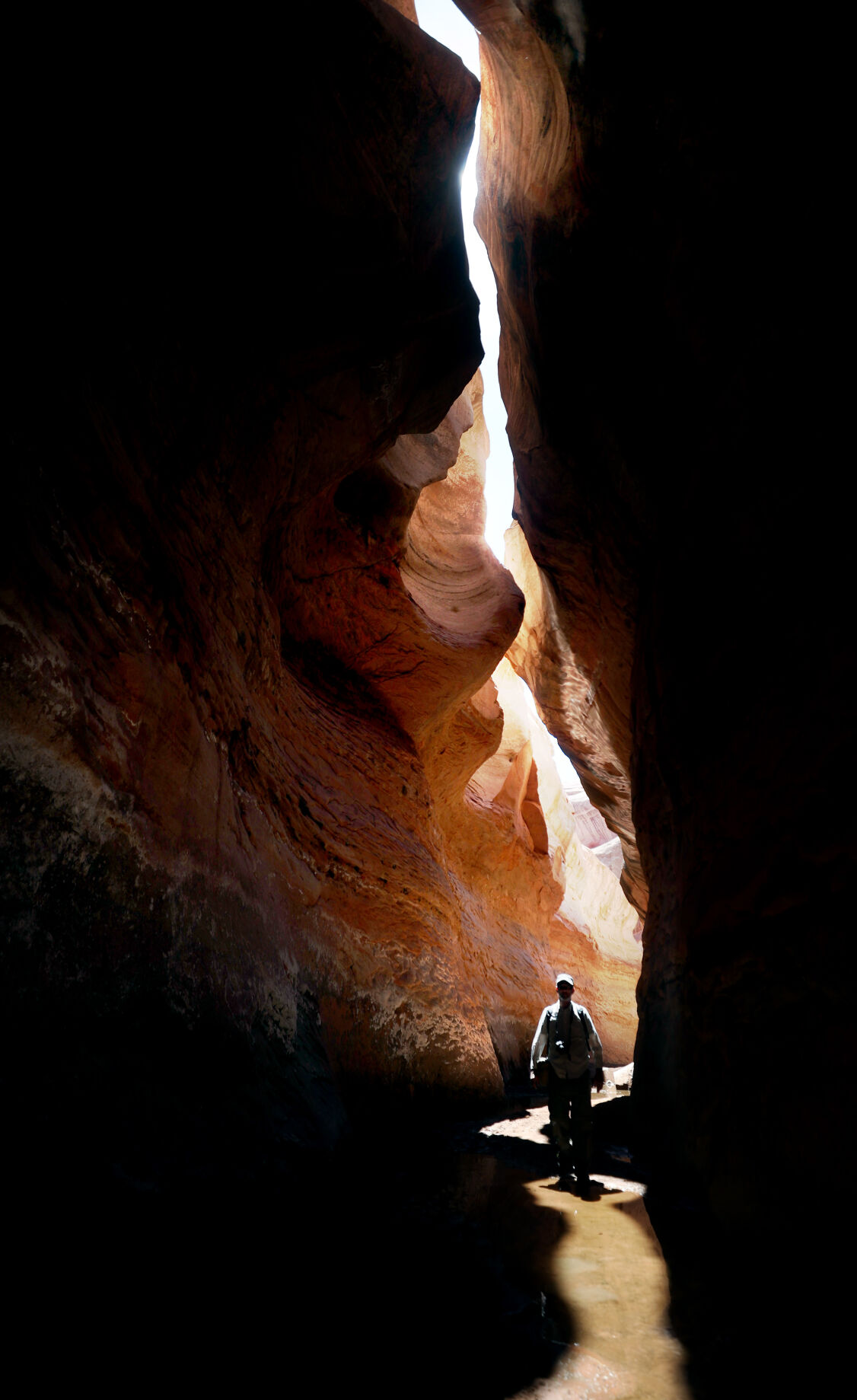
Tom Wright walks through the shaft of light peeking through the narrow openings of the formation called the Subway in Fiftymile Creek, accessible since the waters of Lake Powell have fallen dramatically.

A narrow sliver of sky is visible overhead through the narrow opening of the formation called the Subway, Fiftymile Creek, accessible since the waters of Lake Powell have fallen dramatically.

The dark streaking, called Desert Varnish, is from the seepage of oxidation in the rocks, and is beginning to erase the "bathtub ring", the lighter colored marks left by the waters of Lake Powell on canyon walls, Fiftymile Creek, Glen Canyon National Recreation Area, Utah.

The remains of a small boat, underwater for years, reemerges due to receding water levels of Lake Powell in the Glen Canyon National Recreation Area, Utah.
Frank Colver makes his way over the dried and cracking silt left where the Escalante River joins Lake Powell, Glen Canyon National Recreation Area, Utah. The receding water of the lake has the river cutting through the decades of accumulated silt to form a delta where it meets the lake.

A warning buoy sits high and dry far from the end of the closed public boat ramp at Bullfrog Bay, Glen Canyon National Recreation Area.

A line of tires that were once breakwaters at Bullfrog Bay Marina are now stranded on the rocky landscape high above the current water levels at the Glen Canyon National Recreation Area, Utah.
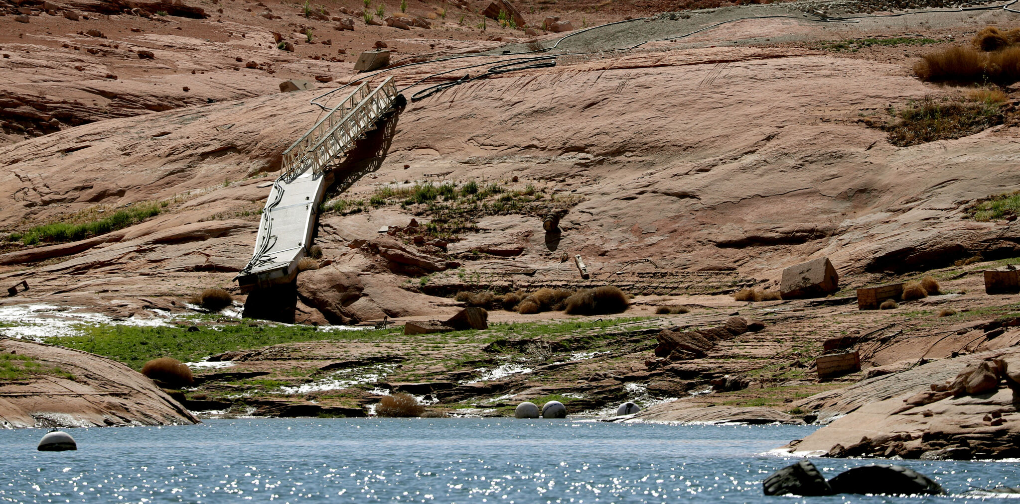
A pedestrian ramp lies well above the water levels at Bullfrog Bay in the Glen Canyon National Recreation Area, Utah.

A stranded wakeless zone buoy sits on the cracking silt outside the new shores of the Bullfrog Bay Marina, Glen Canyon National Recreation Area, Utah.

The end of the ferry ramp ends well short of the new water levels of Bullfrog Bay on the Glen Canyon National Recreation Area, Utah.

An early riser watches the sun come over the low waters of Bullfrog Bay Marina, Glen Canyon National Recreation Aria, Utah. The lighter colored areas on the canyon wall mark previous water levels.

A group of river rafters drift west on the current of the San Juan River outside Mexican Hat. The San Juan feeds Lake Powell.

The tops of a few cottonwood trees begin to poke out of shrunken water of Lake Powell, Fiftymile Creek, Glen Canyon National Recreation Area, Utah.

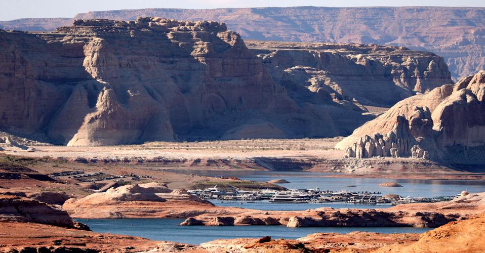
The remaining large water craft and house boats are crowded together in one of the last areas of water deep enough to support them at Wahweap Mariana, Glen Canyon National Recreation Area, Page, Ariz.

The waters of Lake Powell are twenty to thirty feet below the end of the public boat ramp at Wahweap Mariana, Glen Canyon National Recreation Area, Page, Ariz. Personal non-powered craft still use the ramp to unload, but must be carried up and down the banks to reach the water.

A view north from the Wahweap Marina Overlook show the shrunken waters around the marina in Glen Canyon National Recreation Area, Page, Ariz.

The underside of Gregory Natural Bridge, passable for the first time in almost 50 years, over the Fiftymile Creek, Glen Canyon National Recreation Area, Utah.

The moon rises over Gregory Natural Bridge, passable for the first time in almost 50 years, over the Fiftymile Creek, Glen Canyon National Recreation Area, Utah.

The exposed penstocks (intakes to the power turbines) on Glen Canyon Dam in the Glen Canyon National Recreation Area, Page, Ariz. The water level is at its lowest since 1967, when the dam was still being initially filled.

A group of sightseers get a look at the Glen Canyon Dam during a boat tour of Lake Powell, Glen Canyon National Recreation Area, Page, Ariz.

A small fishing boat ties up on the breakwater just outside the intakes for the Glen Canyon Dam, Glen Canyon National Recreation Area, Page, Ariz.. The penstocks (water intakes to the power turbines) are revealed for the first time since 1967 when the Lake Powell was being filled.

Swimmers and bathers use the jagged shores of the newly exposed banks of Lake Powell just above the Glen Canyon Dam, Glen Canyon National Recreation Area, Page, Ariz.

The Glen Canyon Bridge lies in front of electrical towers with feeder lines rising from the hydroelectric plant in the Glen Canyon Dam, Page, Ariz.

Glen Canyon Dam from Glen Canyon Bridge, Page, Ariz.

Small power boats on the Colorado River head upstream just below the Glen Canyon Dam, Page, Ariz.

Wade Quilter walks through the remains of cottonwood and Russian olive trees washed down and joined with silt to form a natural dam where Willow Canyon joins with the Escalante River, Glen Canyon National Recreation Area, Utah,

The remains of a big mouth bass lay in the silt just above where the Escalante River joins Lake Powell, Glen Canyon National Recreation Area, Utah.

The formation known as The Cathedral in the Desert on Clear Creek, Glen Canyon National Recreation Area, Utah. The re-emergence of the formation is drawing sightseers after being submerged for some 50 years.

Tom Wright feels the water oozing from the rocks in the formation known as Cathedral in the Desert on Clear Creek, Glen Canyon National Recreation Area, Utah. The re-emergence of the formation is drawing sightseers after being submerged for some 50 years.

Frank Colver takes a quiet moment and plays a handmade flute near the waterfall in the formation known as Cathedral in the Desert on Clear Creek, Glen Canyon National Recreation Area, Utah. The re-emergence of the formation is drawing sightseers after being submerged for some 50 years.

Jake Quilter walks down the newly cut banks of Clear Creek just outside Cathedral in the Desert, Glen Canyon National Recreation Area Utah. The sand is silt left behind by the receding waters of Lake Powell.

The tops of cottonwood trees that used to be under a hundred feet of water in Lake Powell are visible again in Clear Creek, Glen Canyon National Recreation Area, Utah. The deep water preserved the remains of the trees.

Boaters have to zig-zag through the rocks emerging due to receding waters of Lake Powell, Glen Canyon National Recreation Area, Page, Ariz.

Several images combined for a panoramic view of the Colorado River where it runs through the what once was Hite Marina in the Glen Canyon National Recreation Area, Utah.

A couple of sightseers take in the view from Hite Overlook over the Colorado River and the closed Hite Marina, Glen Canyon National Recreation Area, Utah.

Lone Rock, jutting out of the dry bed, would usually be surrounded by Lake Powell but is now well clear of the water, Glen Canyon National Recreation Area, Utah.

Tires that used to hold the lines well below the surface of Lake Powell are suspended over the water at Antelope Point Marina, Ariz.

Sightseers twenty or thirty feet above get photos of the low water levels of Lake Powell from the public boat ramp at Antelope Point Marina, Ariz.

The pedestrian access ramp ends abruptly twenty feet over the new Lake Powell surface at Antelope Point Marina, Ariz.

The entrance to the pedestrian access ramp of the Antelope Point Marina is taped off after being cutoff from the docks due to receding waters of Lake Powell.
Contact Tony Davis at 520-349-0350 or tdavis@tucson.com. Follow Davis on Twitter@tonydavis987.

Tony Davis
Reporter