


5 p.m. Storm Update
The storm is moving away and new data from the National Weather Service shows it was a record breaker for the region.
Atlantic City International Airport broke the Dec. 18 rainfall record. 2.27 inches of rain fell on Monday alone, beating the old record of 1.10 inches by a large margin. Weather observations have been kept since 1943.
The Monday rain is now the fifth largest one day total in December history. This comes a week after Millville broke the all-time December precipitation record for one day.
Meanwhile, Sen. Frank S. Farley State Marina in Atlantic City experienced 2.08 inches of rain. That nearly doubled the previous record of 1.05 inches. Records at the marina date back 150 years.
People are also reading…
This total kept Dec. 18 out of the top 10 for most precipitation in one December day. This is due to both the lesser amount as well as the longer period of record.
Both of these totals don't count the rain that fell on Sunday, either.
3:30 p.m. Storm Update
Coastal flooding winds down for a number of locations on Monday afternoon. However, it did bring issues.
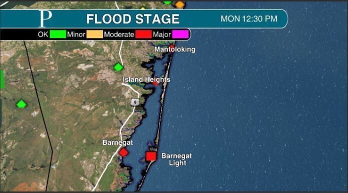
Ocean County largely was in moderate flood stage, the type of flooding that will damage property.
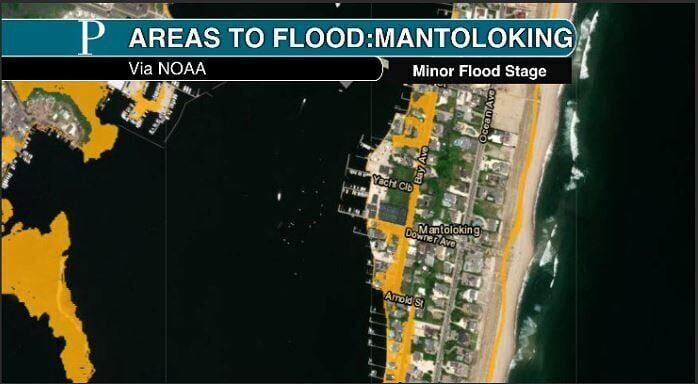
In Mantoloking, Ocean County, flooding has occurred since 2 a.m. Monday. High tide early Monday, pushed it into moderate flood stage. However, when low tide came, waters only dropped to minor flood stage thanks to the offshore wind pushing the water toward the barrier island. Then, as the tide picked up, it went right back in moderate flood stage.
South of there, flood stage was in minor levels. However, a Ventnor resident captured video of a water rescue in town as a person attempted to drive through the salt water. "Significant" flooding was also seen in the 400 block of North Suffolk Avenue in town.
The roughly three inches of rain can't drain out to the bay with the high tide coming up. The combination of the two led to worse conditions that typically seen during minor flood stage.
Power continues to be restored to Atlantic City Electric customers. Only a few hundred outages remained at the time of writing.
A surge of cold air behind the cold front makes it windy outside. Brick Township just reached 41 mph with a gust, with numerous spots up and down the Jersey Shore in the 30s.
More than 4.5 inches of rain fell in Egg Harbor City Dec. 17 and 18, according to a CoCoRaHS volunteer weather observer. That was enough to raise the Union Creek along Havana Avenue above its banks, flooding out the road. A wide swatch of over 4-inch rainfall totals fell in Atlantic County from another powerful Sunday-Monday storm. (DAN FORSHAW/provided)
1:00 p.m. Storm Update
The rain just exited Ocean County and the strongest gusts are over. However, the coastal flooding, the worst of the storm, is underway.
Moderate stage coastal flooding grips Ocean County through the late afternoon. Ocean County held onto the onshore winds the longest. However unlikely most of Monmouth Ocean to the north, there are more back bays, which hold the water in longer.
The worst of the flooding is on the western side of the barrier island, like in Harvey Cedars, Ocean County, Chief of Police Robert Burnaford said. As of 1 p.m., the flooding was in the more typical low-lying spots. However, that will be more widespread into the afternoon.
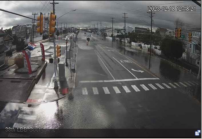
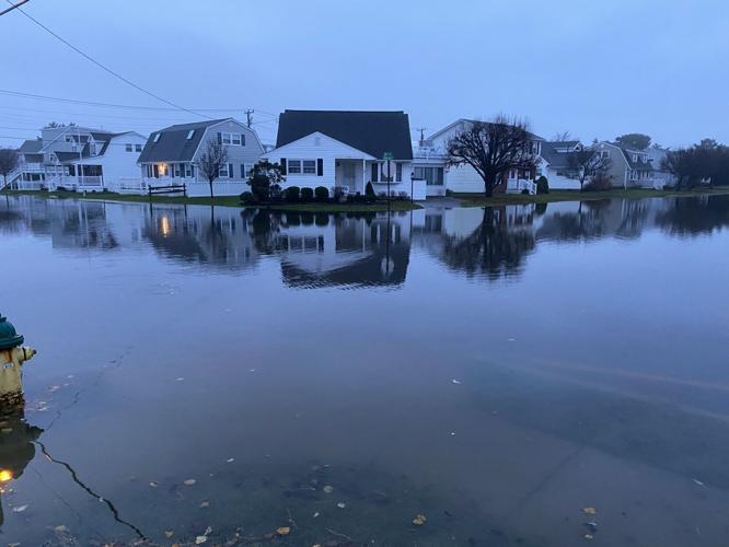
Long Beach Blvd. in Long Beach Township near 38th street shows a flooded lane and a flooded crosswalk coming from the ocean side of the island, toward the Blvd. The photo was taken around 1 p.m. Monday.
Otherwise, the rest of the shore will be in minor flood stage, with up to five inches of salt water on the susceptible bayside roadways.

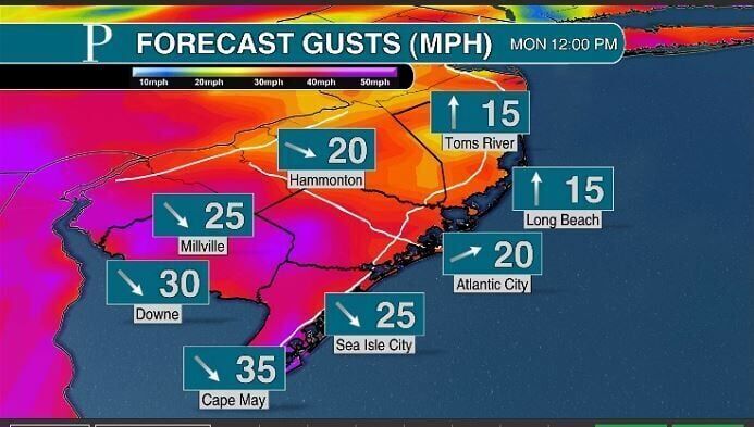
Below are Jersey Shore locations with previous and forecast tide data. The forecasts show whether minor, moderate or major flood stage will be expected.
10:40 a.m. Storm Update
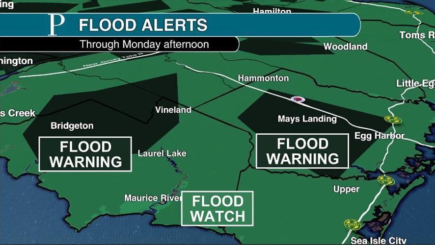
The flood watch has updated to a flood warning in parts of South Jersey, where property threatening flooding will be likely.
The first is for the area surrounding the Cohansey River in Cumberland, Gloucester and Salem counties. Towns like Millville, Vineland and Deerfield are in this warning.
Minor flood stage is expected to occur on the river, thanks to the inches of rain that fell.
Another flood warning for much of inland Atlantic County went out as well. The weather service warns that roads, streams and creeks all are occurring or will occur soon.

Flood alerts as of 10:30 a.m. Monday
If you see flooded water, turn around, don't drown.
9:20 a.m. Storm Update
The worst of the storm has passed. A cold front will push through the state between now and 11 a.m. Once it does so, it'll turn gusty again, with gusts in the 30s expect and temperatures will fall into the the 40s. It'll feel like winter again.
However, this storm from the tropics did produce issues, whether through flooding or power outages.
Roughly 2,000 Atlantic City Electric customers are without power. Overnight, between 1,000 and 2,000 customers were without power at any given time as well, with power being restored by the team as the night went on.
As of the time of writing, 7.3% of Hamilton (Atlantic) is without power, 10% of Weymouth (Atlantic) is without power, 6% of Commercial (Cumberland) is without power and 14% of Greenwich (Cumberland) is without power.
The second torrential rain in two weeks left some roads flooded in the region. Like a wet sponge, water on the already wet ground can't be absorbed from the ground. Therefore, it goes onto roadways and into basements.
In Hammonton, Route 54 was closed in both directions around 5:15 a.m.
Freshwater flooding also gripped Ocean City, with a photo taken from Press reporter Bill Barlow on 53rd street showing water on the road. Egg Harbor Township also reported in street flooding by Frank Holt.

53rd Street in Ocean City experienced freshwater flooding due to heavy rain Sunday into Monday. 52nd street, which typically sees coastal flooding, was clear. (Dec. 18, 2023)
The Union Creek in Egg Harbor City also overflowed near Havana Avenue, with water still rising. 4.54 inches of rain fell at a CoCoRaHS volunteer weather station nearby. Additional stream and creeks may flood as well.
Current view of Union creek in Egg Harbor City along Havana avenue, water is still rising from runoff. Local report from @CoCoRaHS of 4.54” just 2 blocks away. A few trees down an some flooded basements in the area. @NWS_MountHolly @JoeMartWx #NJwx pic.twitter.com/XCH77E82vg
— Dan Forshaw (@Dan_4Shaw) December 18, 2023
Rainfall totals were highest west of the Garden State Parkway.
A flood watch remains in effect for all of New Jersey to highlight the risk for road, stream and creek flooding.
Minor stage coastal flooding was present in the region overnight. This closes down roads but doesn't cause property damage. Expect more of the same between 10 a.m. to 4 p.m. for a few hours as the last round passes through for this storm. A coastal flood advisory is in effect for Cape May, Atlantic, Ocean and Monmouth counties through 4 p.m. to highlight this risk.
With offshore winds blowing, the western side of the barrier islands will have the most flooding.
The Jersey Shore caught a break, too. If the moon was new or full, moderate stage coastal flooding would threaten. Property threatening flooding and tough traveling near the bays would then occur.
The top wind gust was 62 mph in Brigantine, according to the National Weather Service. Many places up and down the Jersey Shore reported a gust over 45 mph. Expect breezy conditions during the afternoon, but they'll be in the 30s. As a result, no additional power outages or wind damage will be expected.
Temperatures will take a tumble during the day, falling from the 50s to the 40s as the day goes on.
Original Weather Forecast
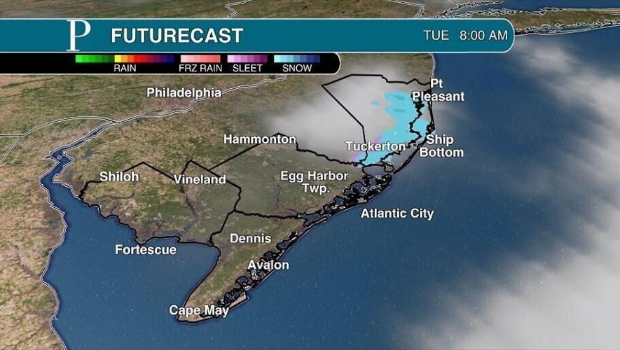
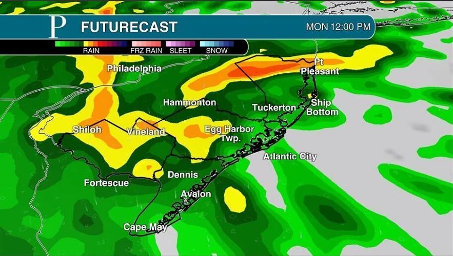
Soaking rain, strong winds and coastal flooding will continue through Monday. However, the wet weather will be gone for the afternoon. The final part of this storm could then be possible snow showers early Tuesday.
Below are Jersey Shore locations with previous and forecast tide data. The forecasts show whether minor, moderate or major flood stage will be expected.
The storm’s fury will continue through the first parts of the daytime Monday.
That means the potential for flooding rain, power outages and wind damage through 7 a.m., the beginning of the morning commute.
After that time, the steady, heavy rain will turn off. In it’s place will be spotty showers. The winds will make a flip during the mid to late morning. Rather than come out of the south, it’ll come out of the northwest.
The rest of the day will see one more round of rain, one more high tide that floods and gusty winds.
The one round of rain will come between 9 a.m. and 2 p.m. It’ll be around that time that a few inches of salt water will be on the road due to coastal flooding. This will be minor, nuisance flooding. However, when you add in the rain falling, issues will be a little more exaggerated. Move your cars if you need to and don’t drive through the flood water.

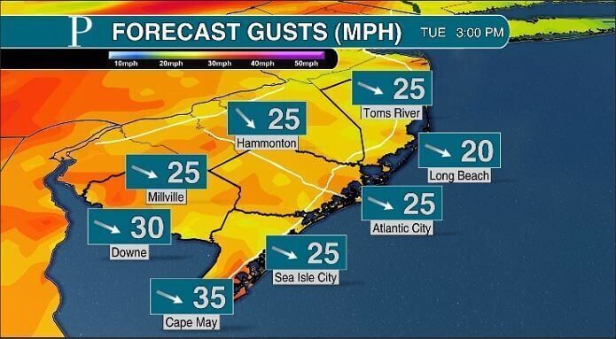
Sustained winds of 15 to 25 mph, with gusts 30 to 45 mph will bel likely for the rest of the day. The breeze will blow hardest at the shore and earlier in the day, when the center of the low pressure will be near. Wind damage will be unlikely but garbage cans will topple over and the inflatables will blow away if they’re not secured.
With the winds out of the northwest, temperatures will be unusual and fall during the day. Sunrise should be in the 55 to 60 degree range, sunset will be in the 4- to 45-degree range.
All in all, expect 1.75 to 3 inches of rain from this storm. This should bring Millville into the top 10 for wettest Decembers on record by Dec. 18. We won’t need rain for a while after this.
It’ll be clear to start the night as a cold wind blows. Temperatures will fall into the 30s.
After midnight, clouds will build in. The center of an upper level area of low pressure will swing through the Northeast. This will deliver the parting shot from this storm.
Rain and snow showers will pass between 4 and 10 a.m., though most precipitation will stay in Pennsylvania. If it snows, it won’t stick but enough to get you in the festive mood as the breeze blows it around. Morning lows will be around 30 degrees and we’ll go up as the day goes on.
Otherwise, the sun will come out. Sustained winds will be 15 to 20 mph during the day from the northwest, with gusts in the 30s.
With the wind and temperatures, wind chills will be below freezing all day long.
From there, it’ll be dry weather for the rest of the week. Expect plenty of sunshine for the rest of the week. The morning will start in the 20s inland, 30s at the shore. Daytime highs will be in the 40s.
In good news for many, next Sunday and Monday, Christmas Eve and Christmas, will not be the third week in a row with a storm. It looks rain free and quiet as can be. Expect it to feel like Christmas, with highs in the 40s.

The El Niño pattern will load the dice to bring numerous storms to the Southeast and Mid-Atlantic, where New Jersey is. However, enough cold air will need to link up with those storms to actually bring snow.
Finally, thanks for trusting us with your storm coverage. That’s true not just with this storm but the one last weekend as well. Whether you watched a livestream, read the weather column and told me your conditions on social media, I appreciate it.


