
Saguaro National Park is getting ready to expand its trail network by 20 percent.
Park officials propose a net addition of 33 miles of trails on top of about 161 miles spanning Saguaro National Park's western and eastern units.
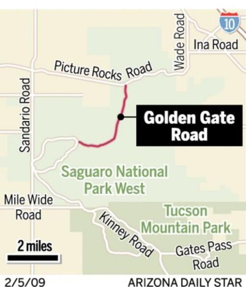
Four miles of existing trails will be closed in the Cactus Forest area of Saguaro Park East. In addition, a stretch of Golden Gate Road in Saguaro Park West will be closed to motor vehicles and redesigned for hikers, horses and mountain bicycles.
It will be up to four years before the park can find money to complete the entire trail network, but some work could start this summer. The plan's overall cost isn't known, National Park Service officials say.
The park officials expect controversy over the plan to close some trails but say that most of those are duplicative.
People are also reading…
Questions and answers about the plan released Wednesday:
Q. What types of new trails will there be?
A. Most will be for hikers and horses only. That's no surprise because 78 percent of the park's 91,440 acres are wilderness, where mountain bikes aren't allowed.
Q. What kind of terrain will the new trails cross?
A. For the most part, it's the saguaro-rich areas that give the park its name.
Q. How steep will they be?
A. Most will be pretty gradual, although a new 4.2-mile stretch of the Arizona Trail to be built in Saguaro Park East's southeast corner will be more difficult, gaining significant elevation, said chief park ranger Bob Love.
In the western unit, new, steep trails to Panther and Safford peaks will accommodate hikers who already ascend by bushwhacking or using poorly defined routes.
Q. Will there be any other improvements?
A. New or improved trailhead parking lots will be built at the ends of Broadway, Speedway and Camino Loma Alta for Saguaro East and two new lots on Golden Gate Road at Saguaro Park West.
Another new trailhead area will be built where Belmont Road connects with the park, in an area where the park service will designate and build several new formal trails to replace existing informal trails.
Q. How is the park faring these days, given current use levels on existing trails?
A. The park service acknowledges that growth around Tucson has placed burdens on the park, it says in this new written plan. It cites extensive visitor use leading to trail widening, soil erosion, vegetation loss and introduction of exotic species. The park also has some undesignated, unmarked "social" trails where hiking can affect sensitive resources and increase erosion.
More visitor use has led to increased conflicts among various types of trail users and increased pressure on the trail system, and some unlawful trail use has occurred, such as mountain bikes going into unauthorized areas, the plan says.
Q: Why carve new trails on a fragile desert, then?
A: The park service is trying to strike a balance between protecting the desert and allowing people to enjoy it, said Saguaro National Park Superintendent Sarah Craighead.
"It's a national park, a public area. Wherever you have people and the environment there are impacts," Craighead said. "We think that where we suggested trails there are steps we can take to help us deal with those impacts. Rather than having people go everywhere, which is the case in some areas of the park, this plan will help us define where people go and where the resources are."
Q. Which part of Golden Gate Road will be closed to motor vehicles and why?
A. It will be a 2.6-mile stretch from Picture Rocks Road to the Sendero Esperanza Trailhead. Although that is the most popular trail in the park's western unit, hikers can still drive to the trailhead from the west, to the park's Red Hills Visitor Center along Kinney Road, and head east from there.
It's being closed because the dirt road fragments the natural environment in an area already isolated from the surrounding wildlands by numerous roads and the Central Arizona Project canal, Love said.
Q. How soon will that close?
A. It could take a couple of years because it will be costly to redesign the road to accommodate hikers, horses and bikes.
Q. Why are four miles of Cactus Forest trails being closed?
A. These trails roughly parallel other trails, some as close as 150 to 200 yards away, Love said. Many are old cattle trails, and "quite frankly they were never very well planned or designed."
Q. How have trails activists and others involved in forming this plan reacted?
A. Mike Headrick, representing an East Side conservation group, said the trail closures may prove unpopular but he can understand why they're happening because many of the users were eroding hillsides and other sensitive areas.
Also, opening up the washes as trails for horses will allow the horses to spread out, where until now large concentrations of horses on existing trails could make them less than desirable for other users, he said.
Mark Flint, a board member of Sonoran Desert Mountain Bicyclists, questioned the use of washes as official trails because they are typically the best wildlife habitats.
"A lot of people like to use them," Flint said. "If animals are not habituated to human use they will not be there."
Q. What's the park's response to that concern about wildlife?
A: The park is trying to preserve smaller washes for wildlife and only designate trails on washes that are wide and open, Love said. In the past, people walked in all the washes and the park hopes to scale that back.
Q. Which segments will be built first?
A. Some new trails in the Cactus Forest area in Saguaro East and in the Belmont Road area in Saguaro West. Closures in the Cactus Forest areas could also start this summer.
IF YOU GO
To see the trails plan and comment on it: Open house, 3-7 p.m. Monday, Amethyst Community Room (CC180) of Pima Community College Downtown Campus, 1255 N. Stone Ave.