

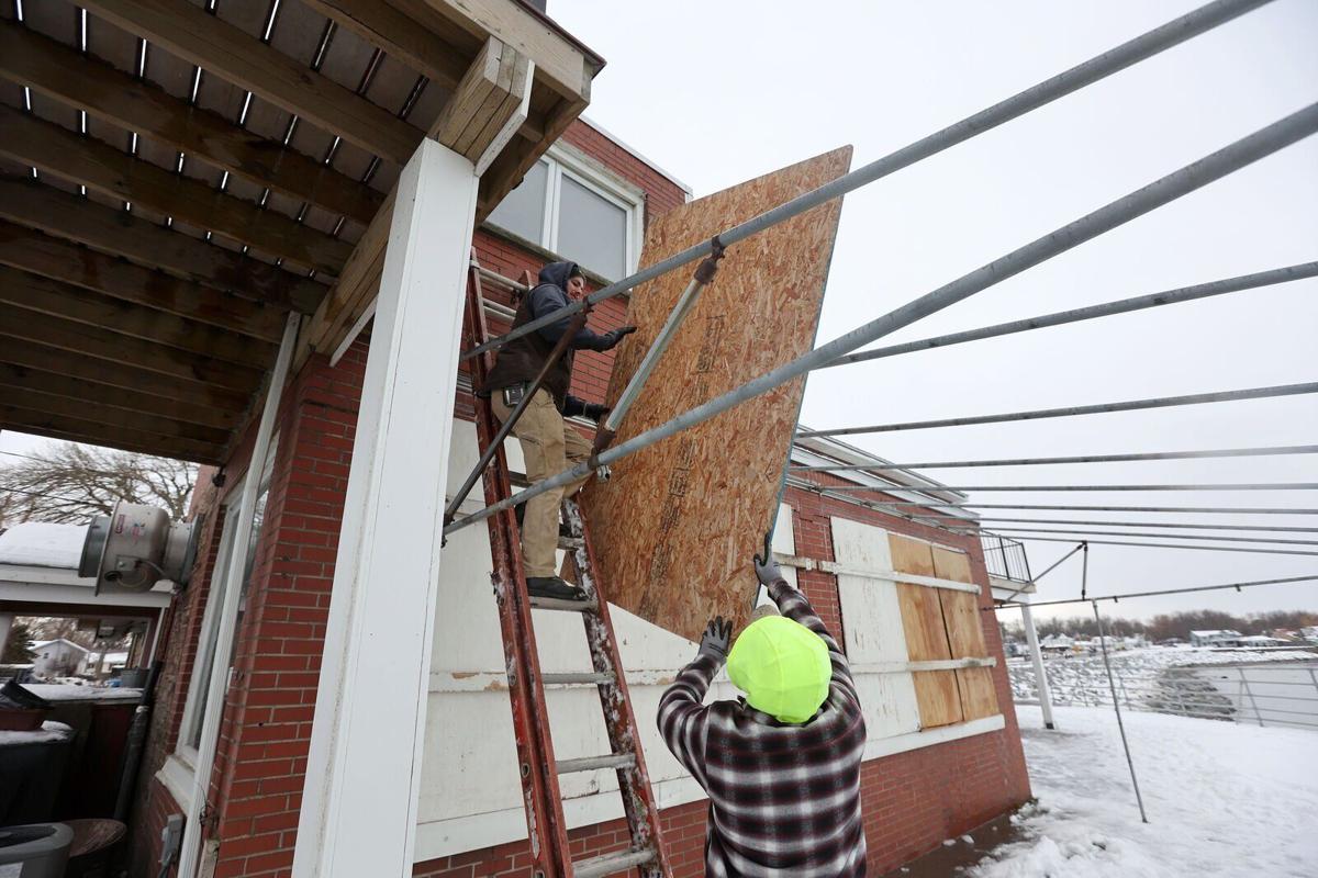
A month after a monster storm dumped more than 6 feet of snow on the Southtowns, an entirely different kind of winter storm is expected to hit Western New York on Friday.
A true blizzard – with heavy lake-effect snow and winds with gusts as high as 70 mph – was expected to barrel into the region Friday morning and not let up for two days.

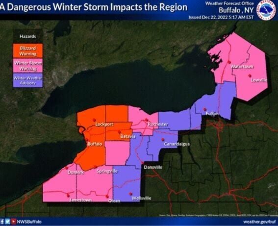
The National Weather Service replaced the blizzard warning with a winter storm warning for Erie, Genesee, Chautauqua and Cattaraugus counties.
- Complete coverage: Blizzard blasts Buffalo; at least three dead
Forecasters on Thursday warned of a perilous combination of power outages, blinding white outs, subfreezing temperatures and lakeshore flooding – an event they say will be remembered for decades.
Meteorologist Don Paul said of the storm: "When it arrives, it will be the most crippling blizzard we've suffered since at least the Blizzard of '85."
People are also reading…
Local leaders couldn't emphasize enough Thursday how potentially dangerous the coming storm could prove to be.

"In the big picture, the storm is coming, and when it arrives it will be the most crippling blizzard we’ve suffered since at least the Blizzard of ’85," writes Don Paul.
"This is not going to be a typical storm," Mayor Byron W. Brown said at a City Hall storm briefing. "In fact, this could be a life-threatening storm."
At the Rath Building, Erie County Executive Mark Poloncarz told reporters it will be "a doozy – the mother of all storms."
Gov. Kathy Hochul, in Niagara Falls, declared it "a storm for the ages."
With the blizzard barreling toward Buffalo, the region began to shut down Thursday.
Most of the region's school districts announced a snow day Friday. Buffalo City Hall will be closed, too. County government buildings will be closed, but workers were expected to report remotely.
Grocery stores on Thursday were packed with shoppers eager to buy storm staples – along with ingredients for holiday feasts.
Commercial vehicles will be banned from the Thruway, between the Pennsylvania line and exit 46, starting at 6 a.m. Friday, Hochul's office announced. Empty and tandem tractor-trailers also will be banned from most major highways in the area.
No other driving bans were announced as of early Thursday evening, but officials declared states of emergency from the state level down to the city, and pleaded with the public to use common sense during the storm and stay home on Friday and Saturday.
"Please stay off the roads," Brown said. "Do not leave home unless you are an essential worker."
Buffalo Public Works Commissioner Nathan Marton also urged motorists to stay off the roads to avoid the effects of heavy lake effect snow and whiteout conditions.
While many use the word to describe a big snowstorm, an actual blizzard must meet specific criteria.
"Not only are we expecting the lake-effect snow that we talked about – right now, we're hearing in the range of 24 inches, 30, or more than that of snow – the winds are really going to be the challenge that we will face this time that we didn't have to face last time," Marton said.
He said the conditions will be dangerous for all, including the city's DPW crew.
"I can't urge you enough, like the mayor said, please don't be on the roads," Marton added.
Poloncarz warned residents to be prepared for the possibility of losing power during the storm – and that the blizzard conditions could mean they'll have to wait to get their lights and heat back on.
"If the power goes out and conditions are such that we can't put our plows on the road, National Grid and NYSEG are not necessarily going to send their crews out because they don't want to put them in a dangerous situation, which means you might have a power outage for an extended period," he said. "That's why we advise and warn now. Be prepared now. It's too late on Saturday. If the power goes out on Saturday, they may not be able to get there for the whole day."

The approaching blizzard, with strong winds with gusts as high as 70 mph, has the potential to cause widespread power outages, according to meteorologists with the National Weather Service office in Buffalo.
Here's what to expect:
Friday
The day will begin with a rapid drop in temperature as a bitter cold front sweeps into the region, setting the stage for the blizzard.
Blizzard warnings from the National Weather Service go into effect at 7 a.m. for Erie, Niagara, Orleans and Genesee counties.
Temperatures will drop from about 40 as the sun comes up to about 15 by mid-afternoon, resulting in a flash freeze that will coat anything that got wet in the rain with ice. That includes roadways, sidewalks, tree limbs and power lines.

Residents were told to be out of their homes by 8 p.m. Thursday. The storm will bring wind and blizzard conditions to the area, starting Friday.
The rain will turn to snow – a combination of widespread synoptic snow and heavy lake-effect snow. However, forecasters say this won't be a typical lake-effect event with a narrow band of heavy snow. Instead, the band will be more spread out "as the strong winds will spray the heaviest snow around."
It will be a pretty wide area, centered over Buffalo and the Northtowns. Much of the region will see at least some snow and with the strong winds, it will be hard to differentiate between the two kinds of snow.
Powerful winds will also kick up with sustained winds close to 50 mph and gusts around 70 mph. The combination is expected to cause widespread blowing snow that will make driving extremely difficult and probably impossible.
In addition, the strong winds are expected to cause a "seiche," pushing the water across Lake Erie onto the shores and Upper Niagara River.
Significant flooding is expected along the Lake Erie and upper Niagara River shores. Very high wave action will also result in significant shoreline erosion, and there will be freezing spray along the lakeshore, according to the weather service.

With a major blizzard expected to hit the region Friday morning, Western New York on Thursda…
Friday afternoon through Friday night
This period will likely see the worst of the wind, said Jon Hitchcock, a meteorologist with the National Weather Service office in Buffalo.
Winds are expected to be strong, with gusts that could exceed 70 mph.
"There will be pretty widespread power outages," Hitchcock said. The areas most likely to see outages are close to the Lake Erie shore and off the Niagara River. "Buffalo, Niagara Falls, that's where the strong gusts will be," he said.
Saturday
The winds will diminish slightly, but will continue to create blizzard conditions, with sustained winds of up to 40 mph and gusts as high as 60 mph. It will also continue to be cold, with a high of just 19 during the day.
The lake-effect snow is expected to become more intense by the afternoon.
"As the wind lets up, the lake-effect band should get more narrow and focused," Hitchcock said.
The timing and exact location aren't clear, but as of Thursday, it appeared the band would be set up over the metro Buffalo area and remain there through the night.
Saturday night
Heavy lake-effect snow and wind will continue through the night. Blowing snow is expected to continue. The overnight low is 17.
Christmas Day
The blizzard warning is set to expire at 7 a.m.
By Christmas morning, the lake-effect band should be drifting south, likely over the Southtowns, possibly further south. The snow is expected to continue through Tuesday.
News staff reporter Samantha Christmann contributed to this report.


