A yearly 1.5 million people visit Summerhaven, the village below Mount Lemmon in the Santa Catalina Mountains. The town is a respite from summer Tucson heat but winter visitors like it, too. Many motorists come via Catalina Highway Scenic Drive, a few cyclists ride the road — and a few visitors come on foot.
About 400 Arizona Trail thru-hikers (from Mexico border to Utah or visa-versa) pass through town, many picking up a resupply box at the Mount Lemmon General Store.
We recently hiked into Summerhaven, but not on the Arizona Trail: hiking 16.9 miles from Catalina State Park over Mount Lemmon and into town, starting at dawn and arriving at a reserved cabin at 9:30 p.m. We wanted to check out the Sutherland Trail — proposed for abandonment by the Forest Service because of damage from the Bighorn Fire of 2020.
I have hiked in the rugged Catalinas since my mid-1970s student days with the University of Arizona Ramblers hiking club (my mother claimed I “majored in hiking, not journalism”). But I had not explored much of the northwestern “backside” trail system, including Sutherland, Samaniego, Cañada del Oro and Red Ridge trails. (I did descend Romero Pass/Pools trail with a friend once, crossing private land to the Oracle Highway. That area is now within Catalina State Park, established in 1984 after proposed Rancho Romero land development triggered public opposition, legislation, land swaps and purchases in the late 1970s.)
People are also reading…

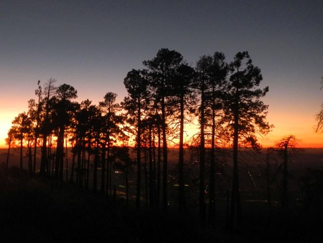
On a 16.9-mile winter day hike from Catalina State Park to Summerhaven, the view of Mount Lemmon ridge at sunset signals there are just six miles left — whew! — to reach the destination village.
The “backside” trails were on my bucket list when my husband and I returned to Arizona as “snowbirds,” but the 2020 Bighorn Fire trashed most of them just before we moved back to Tucson in 2021. Most of the Santa Catalina Ranger District’s 240 miles of trails were closed more than a year for public safety concerns.
As trails reopened, Forest Service officials decided to evaluate the trail system with public involvement. The 2023 Catalina Final Trails Plan proposed 50 miles of new, connecting or adopted trails but also proposed removing almost 30 miles of trail from the system. Many were heavily fire-damaged and lightly used sections of northwest trails I wanted to hike someday.

The Sutherland Trail at Catalina State Park. Some take it all the way to Mount Lemmon ridge and back in a day.
Last November, a friend in the current UA Ramblers hiking club told me she had hiked Sutherland Trail to Mount Lemmon ridge and back in a day. More research was needed.
My spouse, David, wanting a backcountry escape before Christmas rush, proposed we hike to Summerhaven via Sutherland and trails on Mount Lemmon. I could not carry a backpack — recovering from shoulder surgery — but I could hike. So, we would hike to Summerhaven with light packs, spend two nights in town, then return on better trails.
This is why on a mid-December day — one of the shortest of the year — we started our ambitious hike to Summerhaven at Catalina State Park. We went at 7:30 a.m. before the park office opened but followed staff advice to buy 2 day permits ($20 each) at the entrance kiosk, posting receipts on our vehicle parked at the large trailhead parking lot, covering two nights parked in the park.

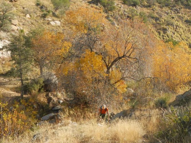
After crossing Cargodera Canyon, shown here, the trail gently switch-backs across side canyons with views of Oro Valley below and, later, “The Window” silhouetted on Pusch Ridge above.
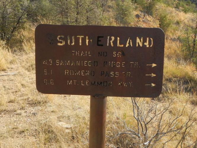
Orangey-pink sunrise sky as we hiked 2.9 miles of Canyon Loop and Sutherland Connector trails to meet actual trail — eroded steep powerline road. After Cargodera Canyon, we left road at old “Sutherland” metal sign for fair trail that gently switch-backed across side canyons with views of Oro Valley below and, later, “The Window” silhouetted on Pusch Ridge above.

An old metal sign marks where trail leaves eroded, steep powerline road on the northwestern "backside" of the Catalinas. The Sutherland Trail is proposed for abandonment by the Forest Service because of damage from the Bighorn Fire of 2020.
Fair trail until we met the Bighorn Fire burn scar. Fire raced up Samaniego Ridge and reburned area torched by the 2003 Aspen Fire (which incinerated Summerhaven, destroying 340 structures). We struggled straight up steep route of sorts through brush, rocks, and competing routes, some marked with cairns (rock piles) by helpful previous hikers, some made by wildlife. We backtracked several times. On ridge we rejoined powerline track: nicer going until final badly burned section where we followed game trail off ridge skirting heavy brush until we realized we were going the wrong way. David clambered straight up ridge over downed logs and brush to get back on track; I grudgingly followed.
We met Cañada del Oro Trail on main ridge at sunset, after 4 hours hiking the last 3 miles. We still had 6 miles to Summerhaven but did OK with headlamps on good trail, then roads. Sunset red-orange glow outlined pine tree grove and lights of Tucson twinkled far below. We never saw the lighted towers on Radio Ridge above us to our left; road circumvented the top and ended at a parking area. We hiked 3-mile paved Observatory Road winding down past Lemmon Ski Valley to Summerhaven, opting for road rather than shorter trails in dark.
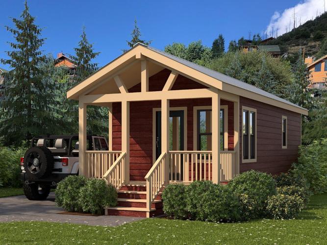
A cozy cabin was a welcome stop. We had reserved a two-night stay at Mount Lemmon Hotel — rustic cabins near center of town — so we could enjoy a “zero day” in the middle of our trek and not carry too much gear. The next morning, we slept late, enjoyed breakfast at Beyond Bread at Mount Lemmon Lodge, and wandered hillside roads to see the many giant summer homes that replaced former modest cabins torched by the Aspen Fire. Must have been very good insurance settlements.

A cozy cabin at Mount Lemmon Hotel is a welcome stop for those who hike in on foot from Catalina State Park.
We bought breakfast sandwiches at the Mount Lemmon General Store for next day’s planned early departure and dinner burgers (to reheat later in our cabin) from Sawmill Run Restaurant, which closes at 4. The early closure accommodates staff who commute from Tucson.
The third day we hiked back to state park on maintained trails: Mint Springs, Wilderness of Rocks, and Mount Lemmon Trail — route of AZT to Romero Pass where it departs down West Fork Sabino. We turned right down Romero Canyon Trail to the park. A youth trail crew from non-profit Wild Arizona had brushed and rebuilt sections of this trail above Romero Pools on Forest Service contract in 2023; but in late 2025, this new trail was already cloaked in brush with some downed trees.
Trail swung back and forth down a dry canyon until we crossed to a campsite by a spring which fed a waterfall, small pool and then a bigger waterfall and deep pool below a cliff. Romero Pools had lots of water. Last section was heavily used trail over a ridge and descending many eroded switchbacks. We did last mile of the 16.1-mile day by headlamp.
After our hike, I checked back with my student friend. She said they had left the park at 7 a.m., got to ridge view of Summerhaven at 4:30 p.m. and back to park at 8:30 p.m. “We were so tired we ran most of the way down.” Not sure we could do that — after the rock pitches on Mount Lemmon and Romero trails, I felt like I had done a few hours on a Stairmaster.
The Final Trails Plan proposes removing from maintenance the Sutherland Trail from the junction to state park boundary due to low use and difficulty following some sections. It’s part of the almost 30 trail miles proposed for abandonment including lower Brush Corrals, Evans Mountain, most of Cañada del Oro, Lower Davis Spring and Samaniego from Peak 7494 to Charouleau Gap.
The abandoned trails would still exist but would degrade without maintenance into “mile-an-hour” bushwack adventures — like our last 3 miles on the Sutherland.