Forty years ago, a volcano in the Cascade Mountains in Washington roared, expelling plumes of ash and killing 57 people in the most destructive eruption in modern US history.
See 50 photos from the 1980 Mount St. Helens eruption in a gallery at the end of this story
It was early morning on Mount St. Helens when the volcano shook the Earth. Accompanied by a magnitude 5+ earthquake and a debris avalanche, the eruption changed the future of volcanology.
Here are five facts about the stratovolcano.
Before erupting, the volcano was 9,677 feet
People are also reading…
More than 1,300 feet was taken off the top of the volcano by the historic blast due to the largest landslide in recorded history.
The current summit elevation of Mount St. Helens, located in Gifford Pinchot National Forest in Washington, is now approximately 8,300 feet.

This is a general view of snow-covered Mount St. Helens in the Cascade Range, southwestern Washington state, on July 17, 1957.
***
Over 230 square miles of forest was destroyed in minutes
Within three minutes of the volcanic eruption, the lateral blast, which traveled at more than 300 miles per hour, scorched 230 square miles of forest. More than 900,000 tons of ash was cleaned up from areas around Washington.
Thousands of animals perished in the eruption. By the end of May, wind-dispersed spiders and beetles were some of the first animals to return to the region.

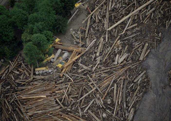
A logging operation along the Toutle River, Wash., about 20 miles from the Mount St. Helens volcanic eruption, is in ruins after flooding from ice and snow melt from the mountain, May 1980.
***
The volcano has had numerous eruptions
Over the last 500 years, Mount St. Helens has had at least four major explosive eruptions and many minor eruptions.
During eruptions between 1980 to 1986 and 2004 to 2008, lava oozed onto the crater floor, "building domes taller than the Empire State Building and restoring 7 percent of the volume lost in 1980," according to the United States Geological Survey.

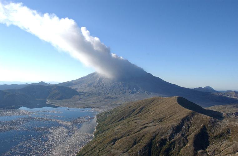
Mount St. Helens exhales a cloud of steam and ash Tuesday, Oct. 5, 2004, at Mount St. Helens National Monument, Wash., in this aerial view showing Spirit Lake in the foreground.
***
The blast killed USGS scientist David Johnston
Volcanologist Dr. David Johnston, a dedicated scientist with the United States Geological Survey (USGS), was swept away by the eruption.
Johnston was one of the first members of the USGS monitoring team to arrive at Mount St. Helens, and was in charge of volcanic-gas studies.
Johnston was one of the scientists who persuaded authorities to limit access to the area around the volcano and resisted pressure to reopen it, "thereby holding the May 18 death toll to a few tens instead of hundreds or thousands," the USGS said.

Tom Johnston of Chicago examines a bronze plaque unveiled at the dedication of the Mount St. Helens Volcanic Monument in Toledo, Wash., May 18, 1983. The father of David Johnston, a U.S. Geological Survey scientist killed after alerting the world to the eruption of Mount St. Helens in May of 1980, said his son would have been proud of the monument.
***
Native Americans abandoned hunting grounds at the volcano 3,600 years ago
An enormous volcano four times larger than the 1980 eruption forced Native Americans out of the grounds nearly 4,000 years ago, the United States Geological Survey said.
Native Americans gave the mountain nicknames, including Lawala Clough, Low-We- and Loowit.
The story behind the mountain, according to a Gifford Pinchot National Forest "Mount St. Helens" Brochure, is actually quite the romance.
According to one legend, Mt. St. Helens was once a beautiful maiden known as "Loowit." When two sons of the Great Spirit "Sahale" -- Wyeast and Klickitat -- fell in love with Loowit, they fought over her, burying villages and destroying forests.
As punishment, Sahale smote the three lovers. In their place he erected three mountain peaks -- Wyeast (Mount Hood), Klickitat (Mount Adams), and Loowit (Mount St. Helens)
Photos: A look back at the Mount St. Helens eruption, 40 years ago
Photos: A look back at the eruption of Mount St. Helens, 40 years ago today
1957: Mount St. Helens, before the eruption

This is a general view of snow-covered Mount St. Helens in the Cascade Range, southwestern Washington state, on July 17, 1957. The volcanic peak is 9,671 feet above the surface of the glacial Spirit Lake.
1975: The peaceful summit of Mount St. Helens

The summit of Mount St. Helens, shown in this 1975 photo, was once a peaceful place where climbers went for a stroll after climbing the mountain that once stretched 9,677 feet into the sky. That was before May 18, 1980 when almost 1,400 feet of the mountain disappeared during a series of violent explosions and eruptions. At right is Mount Adams, another mountain formed by a volcano. (AP Photo/Bruce McCurtain)
March 26, 1980: Earthquakes felt near mountain

George Barker, of the Skamania County Sheriff Dept., tells residents of homes at Spirit Lake that the road was closed due to earthquakes on nearby Mount St. Helens, March 26, 1980. The mountain has been sealed off in case it does erupt as tremors up to four on the Richter scale have been occurring in past days. (AP Photo/Barry Sweet)
March 26, 1980

A spectator scans the northern slope of Mount St. Helens, March 26, 1980. The southwest Washington mountain has been the site of numerous earthquakes the last six days that could signal an eruption, according to a federal volcano expert.
March 30, 1980: Smaller eruptions begin

Mount St. Helens erupts with black smoke and ash, providing a spectacular sight as the cloud drifted skyward, March 30, 1980. The 9,677-foot peak had been a dormant volcano for more than a century until just days earlier. (AP Photo/Jack Smith)
March 30, 1980

Sightseers at Yale Lake watch one of the eruptions at Mount St. Helens, about 12 miles away on March 30, 1980 in Southwest Washington.
March 30, 1980

Black smoke and ash drift skyward as Mount St. Helens erupts, sending a mushroom-shaped cloud more than 16,000 feet into the atmosphere on Sunday morning, March 30, 1980. Mount Rainier, Washington's highest mountain, can be seen in the background.
April 1980

Mount St. Helens in Washington spews smoke, soot and ash into the sky in April 1980. The eruption is the first for the volcano since 1857. (AP Photo/Jack Smith)
April 2, 1980

In this image provided by NASA, is an aerial view of Mount St. Helens, active volcano in Washington state, April 2, 1980.
April 2, 1980

A caravan of rented trucks pass through a police roadblock, April 2, 1980, in Cougar, Wash., as they leave a restricted area near the base of Mount St. Helens. The trucks carry personal and official belongings of U.S. Forest Service employees of the evacuated St. Helens Ranger Station.
May 1, 1980: Research between eruptions
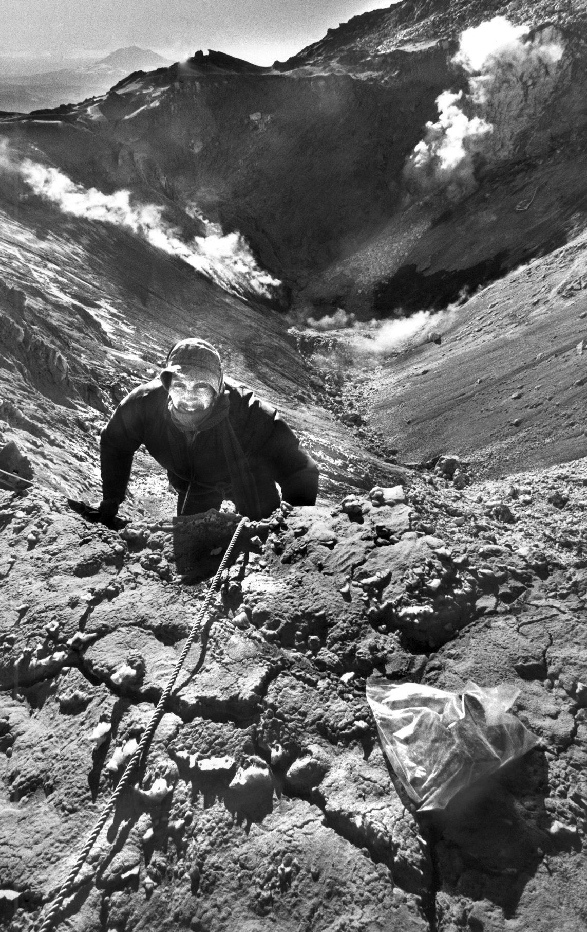
Portland State University geologist Leonard Palmer climbs out of the crater atop Mount St. Helens after collecting ash samples - bag in foreground - on May 1, 1980. (AP Photo/Tim Jewett)
May 18, 1980: Massive eruption at Mount St. Helens

Mount St. Helens sends a plume of ash, smoke and debris skyward in its most violent eruption to date, May 18, 1980. The volcano, located 45 miles northeast of Portland, Wash., became active on March 27. Flooding in some areas has been triggered by the volcano and residents have been evacuated. (AP Photo/Jack Smith)
May 18, 1980

In this photo provided by the U.S. Geological Survey, is an aerial view of the eruption of Mount St. Helens volcano, Wash., May 18, 1980. White linear features are logging roads; dark patches are trees.
May 18, 1980

Mount St. Helens in Washington state is shown in various stages of eruption, May 18, 1980. (AP Photo/Vern Hodgson)
May 18, 1980

Volcanic ash and steam rise from Mount St. Helens, Wash., as it erupts, May 18, 1980.
May 18, 1980

The streets of Yakima, Wash., are dark at 3 p.m. after an eruption at Mount St. Helens, on May 18, 1980. White volcanic ash covers the streets and passersby wear masks to avoid breathing the ash. (AP Photo)
May 19, 1980

Ashen clouds from the Mount St. Helens volcano move over Ephrata airport in Washington on Monday, May 19, 1980 in the days after the volcanic eruption. (AP Photo/Mike Cash)
May 19, 1980: Eruption triggers mudslides, flooding

High water and mudslides caused heavy damage to this house located along the Toutle River in Washington, May 19, 1980. Eruptions from Mount St. Helens have triggered flash floods and mudslides. (AP Photo/Jack Smith)
May 19, 1980

Houses along the Toutle River are caught in the flood following the aftermath of the eruption of Mount St. Helens, Wash., when rapid ice and snow melt caused rivers and streams to rise rapidly, May 19, 1980.
May 19, 1980

Bob Brown, left, and his brother John attempt to lead three horses to safety out of the Weyerhaeuser 19-mile yard log in Kid Valley, Wash. The yard was flooded by the Toutle River following the eruption of Mount St. Helens. (AP Photo/Gary Stewart)
May 19, 1980

John Brown is covered with mud and exhausted following his unsuccessful rescue attempt of three horses in a log yard flooded by the Toutle River after the eruption of Mount St. Helens, Washington state, on May 19, 1980. Although Brown was helped by at least three other individuals, all efforts to save the horses failed. (AP Photo/Gary Stewart)
May 19, 1980

Bridge on Interstate 5 and railroad bridge beside it with steaming river flowing beneath are pictured about 20 miles from Mount St. Helens, Wash., May 19, 1980. The river contains hot water in the aftermath of the volcanic eruption. (AP Photo)
May 20, 1980

A car is shown submerged in ash in this May 20, 1980, photo after the Mount St. Helens eruption in Washington state.
May 20, 1980

A camper containing two victims of the Mount St. Helens eruption sits amidst the gray landscape about 8 miles from the mountain. Markings in the volcanic ash in front of and behind the camper were left by a helicopter and a searcher who found the victims on Tuesday, May 20, 1980.
May 20, 1980

In this May 20, 1980 file photo, trees knocked down by the May 18, 1980 eruption of Mount St. Helens are shown along a logging road near the south fork of the Toutle River in Washington state.
May 20, 1980

Denuded trees lay like matchsticks in the changed landscape around Mount St. Helens, Wash., shown two days after eruption, May 20, 1980. (AP Photo/Jack Smith)
May 20, 1980

Ivan Sharpe, San Francisco Examiner reporter and paramedic Sgt. Richard Harder of Portland, Ore., are hoisted into Air Force Reserve helicopter of 304th Squadron on Tuesday, May 20, 1980, after Sharpe became stranded in heavy ash on Green River ridge near erupting Mount St. Helens. Both were slightly injured and taken to Kelso, Wash., hospital.
May 20, 1980

Residents stop and try to remember how the Old 99 Steelhead Drive near Longview used to look before the mud and logs started to cover it from the eruption of Mount St. Helens, some 50 miles away, May 20, 1980.
May 22, 1980: Rescue operations

Army Warrant Officer Charlie Wesler pulls a saddle from a campsite near the Mount St. Helens volcano on Thursday, May 22, 1980. A body was removed from the campsite a day earlier. (AP Photo/Gary Stewart)
May 23, 1980

Army Warrant Officer Charlie Wesler looks over the remains of a tent at a campsite near the Mount St. Helens volcano, May 23, 1980. The Army is assisting in the search for survivors. (AP Photo/Gary Stewart)
May 23, 1980

Silt, logs and debris fill this yard and driveway of a home that is looking for a buyer in Castle Rock, Wash., May 23, 1980. The nearby Cowlitz River overflowed its banks when a flash flood roared through the area after violent eruptions on Mount St. Helens. Cleanup operations are continuing. (AP Photo/Sal Veder)
May 23, 1980

Three vehicles are covered with ash and debris near the Mount St. Helens volcano in Wash., on May 23, 1980. Rescue efforts were underway for between 70 and 90 persons still missing in the area. (AP Photo/Gary Stewart)
May 24, 1980

Residents of Moses Lake, Wash., dig large deposits of volcanic ash that were dumped on the city from the volcano Mount St. Helens, May 24, 1980. Lake Moses is about 150 miles from Mount St. Helens in central Washington. (AP Photo)
May 25, 1980

Leslie Zumwalt wipes the windshield of a light plane in Vancouver, Wash., as ash accumulated in the Portland metropolitan area after an eruption on Mount St. Helens, May 25, 1980. Light planes were grounded and jetliners were not flying north toward the mountain because of the ash. (AP Photo/Jack Smith)
May 25, 1980

A motorcyclist moves along a Portland, Ore., street, May 25, 1980, despite ash from erupting Mount St. Helens, that blanketed the area. (AP Photo/Eric Risberg)
May 26, 1980

Two women cover up as they walk along a Portland street, May 26, 1980, after Mount St. Helens erupted spewing ash skyward with some of it landing on the city. Work crews have already started washing off the streets. (AP Photo/Bill Haber)
May 26, 1980

Workers hose down a Portland, Ore., street after ash from the volcano Mount St. Helens drifted over the metropolitan area, May 26, 1980. More ash could drop on the city as the mountain continues small eruptions. Mount St. Helens is located 45 miles northeast of Portland in southwest Washington. (AP Photo/Bill Haber)
May 26, 1980

Portland, Ore., residents wear protective masks to keep from breathing in ash from the nearby Mount St. Helens, which continues to have small eruptions, May 26, 1980. The volcano is located 45 miles northeast of Portland, in southwestern Washington state. (AP Photo/Bill Haber)
May 27, 1980

A small dog that was evacuated during the Mount St. Helens eruptions sits in its cage in Longview, Wash., May 27, 1980. (AP Photo/Gary Stewart)
May 27, 1980

Fifteen-year-old Heidi Havens gives Allen Troup, 16, a kiss as he prepares to board a Spokane City bus, May 27, 1980. Spokane residents have had to wear face masks while outside for nine days now because of possible health threats from volcanic ash sprayed over the area by Mount St. Helens on May 18. Having had them on for so long, some people are obviously forgetting. (AP Photo/Ralph Viggers)
May 28, 1980

Washington National Guardsmen Spec. 4 Ed Shamp stands watch on the road near Cougar, Wash., where persons entering the restricted area are required to sign in and out, May 28, 1980. Cougar is about eight miles from Mount St. Helens. (AP Photo/Bill Haber)
May 28, 1980

Mount St. Helens vents steam and ash skyward during an eruption Wednesday, May 28, 1980. The crater now extends from side to side on the mountain which is located 45 miles northeast of Portland.
May 28, 1980

Clean-up crews begin a big job in the town of Toutle, Wash., about 20 miles from the base of Mount St. Helens, May 28, 1980. Homes and businesses in that area sustained heavy damage when the Toutle River over flowed its banks May 18 after violent eruptions on Mount St. Helens. (AP Photo/Ed Andrieski)
May 29, 1980

Jan Smith of Castle Rock, Wash., wears a gas mask after Mount St. Helens erupted filling the air with ash and smoke, May 29, 1980. Many areas of the northwest received varying amounts of ash after the May 18 eruption.
May 30, 1980

Bryan Turner hoses off his roof in Toledo, Wash., May 30, 1980, as he tries to remove the last bit of ash. Cleanup continues as the community gets back to normal after eruptions on Mount St. Helens. (AP Photo/Ed Andriesky)
June 13, 1980

A water truck rolls down a Portland, Ore., street early on June 13, 1980, as ash clean-up operations got underway in the wake of a major eruption of Mount St. Helens. (AP Photo/Jack Smith)
Oct. 17, 1980

Mount St. Helens roars to life Friday, Oct. 17, 1980 sending a plume of smoke and ash skyward. The active volcano is located 45 miles northeast of Portland in Washington. Next to Mount St. Helens is Mount Rainier a dormant volcano. The plume was estimated to be 50,000 feet. (AP Photo/Jack Smith)
May 11, 1981

Workers plant new trees among dead trees in an area near Hoffstadt Creek, Mount St. Helens, in Washington state, May 11, 1981. While some plants are coming through the volcanic ash, new trees will be needed to rebuild the forest.
June 19, 1996

The lines of the Fremont Bridge in Portland, Ore., Wednesday, June 19, 1996, create a study in form against Washington's Mount St. Helens while Mt. Rainier is barely visible through the bridge's uprights. Mount St. Helens is an active volcano that last erupted May 18, 1980, covering much of Portland and the Pacific Northwest with volcanic ash. (AP Photo/Don Ryan)
May 18, 2010: Remembering the victims

In this May 18, 2010 file photo, a memorial to those who lost their lives in the May 18, 1980 eruption of Mount St. Helens is shown near the Johnson Ridge Observatory at the Mount St. Helens National Volcanic Monument in Washington state. (AP Photo/Ted S. Warren, file)