

The National Geographic Society wants to put us on the map.
And we're all invited to help decide exactly what the map will show.
The society, known for its colorful magazines and richly detailed cartography, is launching a project — with help from regional partners — to produce a Geotourism MapGuide of the Sonoran Desert Region.
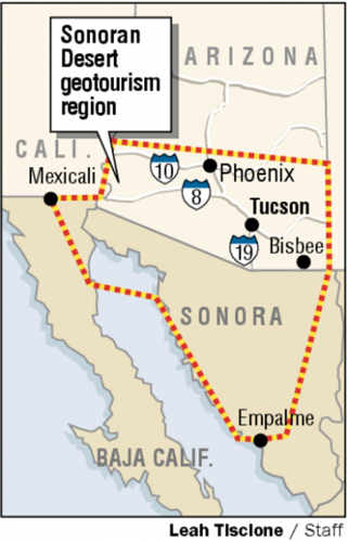
A far cry from your basic road map, the MapGuide will cover more than 84,000 square miles of Southern Arizona, Sonora and Baja California. It will zero in on 200 to 300 special sites nominated by the public — each site remarkable for its scenery, history, culture, art or cuisine.
One entry on the map might direct you to a magnificent canyon. Another could point out a remote historic site. Still another might clue you in on a place to get handmade tortillas.
People are also reading…
The mega-map, to be printed in English and Spanish, is intended to promote sustainable tourism and regional pride in an area extending south from Phoenix to Empalme in Sonora. The area reaches west to Mexicali in Baja California and east to the Bisbee area — but those general boundaries could be altered during the planning process.
The MapGuide "will celebrate that sense of place that makes the Sonoran Desert region unique — with its incredible cultural, social and natural diversity," said James Dion, spokesman for the Geographic Society.
"The focus," Dion said, "is geo-tourism. By that, we mean tourism that sustains or enhances the geographical character of the place being visited — its environment, culture aesthetics, heritage and the well-being of its residents."
Organizers of the project want your input from the get-go.
The Geographic Society and its regional partners — the Arizona and Sonora offices of tourism, the Sonoran Institute and the U.S. Bureau of Land Management — are seeking nominations for items to appear on the map.
"We're encouraging people to nominate everything from music, food, crafts and dance to scenic landscapes and historic sites — anything a visitor might be interested in," Dion said, noting that some text blocks on the map would include a picture of the described site.
"Where is there a really good little mariachi band playing on Friday nights?" he said. "Where's a good bed and breakfast — maybe an old historic ranch? These are things that might make nominations."
Nomination forms are available on a Web site — www. sonorandesertgeotourism.org — or by calling the Sonoran Institute at 290-0828.
More information on nominations will be provided at upcoming public forums.
Dion said nominations are due by April 10, and that the Geographic Society will make final decisions as to which entries appear on the map. The MapGuide will be available for distribution through the Arizona and Sonora offices of tourism — and on the Internet — by the spring of 2007, Dion said.
Luis Iribe Murrieta, spokesman for the Sonora Office of Tourism, said he sees the project as an "opportunity to promote Sonora and our region worldwide."
"We are focused on transforming Sonora into a real international tourist hot spot and destination," Iribe said. "We believe that this bi-national initiative — with the new trend of tourism called geotourism — will help in this effort."
Wendy Erica Werden, communication director for the Sonoran Institute, sees the map project as a way to bring out the best in area residents and tourists alike.
"It's giving the people who live here a sense of stewardship — realizing that they have a responsibility to preserve these special places and things not just today, but for generations to come," Werden said.
"At the same time, we want to build a type of tourism that gives people a personal connection," she said. "Maybe they always want to eat at El Charro when they come to Tucson. We want people to vote with their dollars that they want to help us protect and enjoy the Sonoran Desert."
Monica Durand, marketing director for La Ruta de Sonora, a nonprofit organization promoting ecotourism in the border region, views geotourism as having a broader base than ecotourism.
"Geotourism promotes all economic aspects of an area" rather than focusing mainly on tourism related to natural resources and conservation, Durand said. "It highlights local products and local artists, and it opens new opportunities for small businesses" that cater to tourists.
The estimated $100,000 cost of producing the MapGuide will be shared by the Sonora and Arizona offices of tourism, Durand said.
Marci Elizondo, executive projects manager for the Arizona Office of Tourism, said the new map will be decidedly different from tourist guides that focus mainly on resorts and well-known attractions.
"This will give tourists a feeling that they're going to see something besides Disneyland," Elizondo said. "And it will build local pride for people to literally see themselves on the map."
Perhaps the toughest part of the task, Elizondo said, will be choosing the final map entries from hundreds of nominations.
"It's going to be so hard to narrow it down," she said. "But National Geographic will be saddled with that difficult task."
The map project began in December, when the Geographic Society and its regional partners signed a charter making the Sonoran Desert region the fifth geotourism region in the world. The other geotourism projects are in Appalachia, Norway, Honduras and Romania.
In addition to creating the MapGuide, the charter calls for forming a regional council to promote geotourism.
● Two upcoming forums in Tucson will provide information on making nominations for the Geotourism MapGuide.
l Wednesday — 6 to 8 p.m. at the Arizona Daily Star, 4850 S. Park Ave. Register in the lobby.
l March 15 — 4 to 6 p.m. at the Tucson Botanical Gardens, 2150 N. Alvernon Way. Meet in the education classroom.
● To make a nomination online go to www.tucson.com/go/ geotourism