
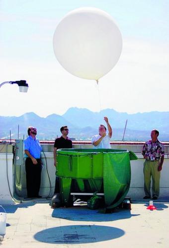
Twice a day, every day, a white, 5-foot-diameter helium balloon will soar from a University of Arizona campus rooftop, dangling a miniaturized weather station that could improve weather forecasts and speed up hazardous-condition warnings.
We still won't be able to do anything about the weather, but with the new weather balloons and instruments, meteorologists will know more about the atmosphere directly over Tucson — and know it sooner, said Eric Pytlak, science and operations officer for the Tucson office of the National Weather Service.
The new, improved instrument package — called a rawindsonde — samples temperature, barometric pressure and humidity every second instead of every six seconds and provides a more detailed map of the atmospheric conditions over Tucson, Pytlak said. "The GPS (Global Positioning System), the tracking, is the big thing."
People are also reading…
Because of the GPS, Pytlak said, wind speed monitoring— including critical wind shear information — is enhanced. It's those changes in wind direction — shears — that can tip off meteorologists to the formation of violent storms, he said.
Starting in 1948 NWS weather balloons were launched from Tucson International Airport carrying weather instruments and a radio that sent atmospheric data back to a ground station. Since 1997, when the weather service's Tucson operation left TIA for the UA campus, the TIA launches have been handled by a contractor, Pytlak said.
The NWS, under the U.S. Department of Commerce's National Oceanic and Atmospheric Administration, now operates out of a building on the northeast corner of the East Sixth Street and North Park Avenue intersection on the UA campus.
The last of those TIA launches took place Sunday.
Now the balloons are launched from the UA rooftop at roughly 4 a.m. and 4 p.m., seven days a week, 365 days a year.
Monday afternoon, a group of meteorologists, under the eye of a trainer, methodically prepared to launch the afternoon balloon from the roof of the Environment and Natural Resources Building.
The balloon is filled with helium to about one-third its capacity to allow the gas inside to expand without breaking the balloon before it has finished its job — possibly as high as 100,000 feet.
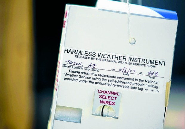
Tied to 50 feet of what looks like common string, the rawindsonde, packed in a white paper box that looks like a Chinese carryout container, hangs from a hook on a wooden frame. The meteorologist slowly releases the balloon from the cradle, feeding out the line until all the slack is taken up and the radiosonde can clear the building's parapet.
Within a minute it's nearly 1,000 feet over Tucson, apparently heading toward Sonoita.
One floor below, a bank of computer screens and a special location monitor show the data coming in from the rawindsonde — location, temperature, barometric pressure and humidity. The meteorologists can extrapolate other information, including wind speed, wind direction, dew point and more.
Tom Evans, the warning coordinator meteorologist for the Tucson office, and the others at the console monitoring the flight seemed pleased with the data flood pouring in.
There's nothing exciting happening up there today, Pytlak said, but soon — when there's more moisture and more action in the atmosphere over Tucson — the pile of information could give us a break on the kind of wild weather that tore up Sabino Canyon late last summer.
The information that comes back from the balloon is verified and then sent to computers running weather-modeling software at NWS headquarters that spit out and return forecasts based on the information.
Later, when the balloon pops, maybe as far as 100 miles away, a parachute will deploy, floating the rawindsonde to the ground. Pytlak says about 20 percent of them are found. They carry a message that it is just a "harmless weather device" and a prepaid postage envelope for returning the device for reuse.