7 Day Forecast
Lake Powell, the giant reservoir on the Utah-Arizona border that helps power millions of homes, has fallen to its lowest level ever amid a worsening Western drought exacerbated by climate change.
The lake's surface dropped to 3,519.91 feet above sea level Aug. 15, according to the Bureau of Reclamation's automated gauge system. The previous low was 3,519.92 feet, reached in April 2023. Dropping below 3,490 feet could imperil the lake's ability to generate electricity, and federal officials have been pulling water out of smaller reservoirs upstream to help delay reaching that level.
Nevertheless, the lake could fall close to that level, known as minimum power pool, early next spring, according to federal predictions. Further drops could take the lake to what's known as "dead pool," where it's too low to flow downstream. That could spark draconian cuts to how much drinking water is available for millions of people and imperil farms 500 miles away in California's Imperial Valley.
People are also reading…

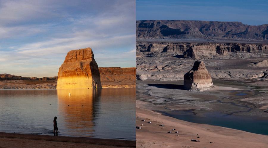
The photo on the left shows Lone Rock at Lake Powell in 2007. The photo on the right is from earlier in 2026.
The lake's level is recorded daily by automated gauges, and the Bureau of Reclamation cautions that readings could be later revised. But the lake has been on a downward trajectory for months and was widely expected to reach this mark around mid-August.
Drought has complicated management of Lake Powell and Lake Mead outside Las Vegas. Lake Mead fell to its lowest level ever on Aug. 7 and is now setting a new record low daily. The Lake Powell area draws an estimated 4 million recreation visitors a year to houseboat, water-ski and kayak on the lake and enjoy its scenic side canyons, along with the Rainbow Bridge rock arch.
Climatologists and other water supply experts say a long-term drought is being exacerbated by climate change, which is altering how much snow falls in the Rocky Mountains before melting into the Colorado River.
The West is warming faster than the country overall, which ultimately means less water available for farmers, businesses and residents, Peter Goble, assistant state climatologist for Colorado, told USA TODAY earlier this year.
"There's no way to look at the numbers and think the Colorado River is doing well right now," Goble said. "In a world that's warmer, all signs point to droughts that will be more intense and more frequent."
In June, Aaron Weiss, executive director of the Center for Western Priorities, told USA TODAY the fixes will be "both really hard and really urgent."

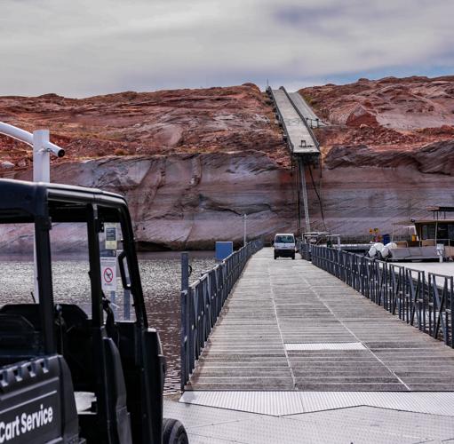
The end of a floating dock hangs off a cliff in February at Antelope Marina on Lake Powell in Page, Ariz.
"Whatever the solutions are, they're going to have to happen rapidly."
In addition to limiting lawn irrigation and paying farmers to use less water, some proposals to protect Powell and Mead call for piping water from the Mississippi River into Arizona, hauling icebergs from the polar regions or building nuclear-powered desalination plants off the California coast.
Several environmental groups have proposed removing or entirely bypassing the Glen Canyon Dam, draining what's left into Lake Mead, and implementing stricter water conservation measures.
The two reservoirs provide hydroelectricity, drinking and irrigation water to millions of Americans across the West by storing up the Colorado River. The only time they have ever been this low was when they were first being filled.
The river serves seven Western states, Native American tribes and two northern Mexican states with water for agriculture, irrigation and drinking, hydroelectricity, recreation and fish and wildlife habitat. The Glen Canyon Dam created Lake Powell, and the Hoover Dam created Lake Mead.
The Powell-Mead reservoir system was designed to store water during extra-wet years and release it during dry years. But long-term trends mean less snow is falling on the Colorado Rockies. Complicating matters, rapid growth of the West ‒ possible in large part because of the reservoirs ‒ has placed extra demand on the system.
A federal plan released last month calls for significantly reducing the amount of water flowing out of Lake Mead, which would make it harder for farmers in California and Arizona to irrigate their crops and might require additional water-saving measures in many cities.
Neither lake will gain significant new water until next spring, and only then if the winter is a wet one. The 2025-2026 winter was unusually dry and warm, and climatologists say they expect Colorado River flows will continue declining in the decades to come. A wet fall caused by a super El Niño weather pattern in the Pacific Ocean could help, but experts say it won't reverse the long-term trends.
A federal study says Lake Mead will be too low next April to run 70% of the Hoover Dam's turbines. Nevada utilities are already warning about rate hikes. Upstream at Lake Powell, the Glen Canyon Dam is within feet of losing power generation entirely, and those turbines back up the country's second largest nuclear plant. There is a number for how much a foot of Lake Mead is worth on your bill. Full story at the link: https://san.com/cc/what-does-low-water-at-the-hoover-dam-mean-for-power-in-the-american-west/?utm_campaign=aud-dev&utm_medium=social&utm_source=youtube&utm_content=owned Follow Straight Arrow on social media: Facebook: https://www.facebook.com/straightarrownews X: https://x.com/StraightArrow__ Instagram: https://www.instagram.com/straightarrownews/ TikTok: https://www.tiktok.com/@straightarrownews Bluesky: https://bsky.app/profile/san.com Sign up for our newsletters: https://san.com/newsletters/ Stay on top of the news with our app: https://san.onelink.me/qhTT/social