

The first official warning that something big was approaching – not just your usual Western New York snowstorm – came at 2:22 pm. on Tuesday, Dec. 20.
The National Weather Service office in Buffalo that afternoon issued a "winter storm watch" cautioning that unusually bad weather would hit the region Friday, Dec. 23, through Monday, Dec. 26 – a rapid freeze, followed by lake-effect snow and strong winds that could cause blizzard conditions.
"Travel for the holiday weekend, including Friday, could be very difficult to impossible at times," the weather service said in the Tuesday afternoon alert.
It was the last thing anyone wanted to hear five days before Christmas. The year of 2022 had already proven to be an especially difficult year for Buffalo, including the worst outbreak of Covid-19 since the beginning of the pandemic, the horrific massacre at the Tops Markets store on Jefferson Avenue and a November lake-effect snowstorm that dropped more than 6 feet of snow in some areas of the Southtowns.
People are also reading…
Yet, a another major storm was brewing across much of the nation. Buffalo would soon be its bull's-eye.
Looking back at weather bulletins, meteorological data, briefings from local officials and firsthand accounts, here's how the Buffalo Blizzard of 2022 unfolded.
WEDNESDAY, DEC. 21
Calling the approaching storm a "once-in-a-generation event," forecasters with the weather service and on TV began issuing increasingly dire warnings about the encroaching storm. Get any holiday shopping done by the end of Thursday, they said. There was increasing likelihood that the weather would take a drastic turn Friday morning.
"Old Man Winter will unleash the full fury of winter upon our region during this period," the weather service said in a forecast update Wednesday morning.
Those with plans to travel for the holidays scrambled to leave town or get those loved ones here ahead of the storm.
Bishop Michael W. Fisher issued a message to Catholics in the Diocese of Buffalo advising them to check with their parishes before venturing out to Mass during the holiday weekend storm.
THURSDAY, DEC. 22
3:54 a.m. – The Weather Service issued a rare "Blizzard Warning."
The forecast predicted 1 to 3 feet of snow, wind gusts as high as 70 mph and wind chills as low as minus-10 to minus-20. "Widespread blowing snow could significantly reduce visibility. Very strong winds could cause extensive tree damage and numerous power outages," the weather service warned.
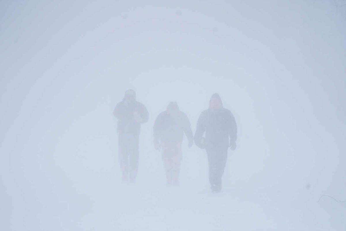
Meteorologists are very careful about using the word "blizzard." While it's often used by people to mean a bad snowstorm, a true blizzard, like the one barreling toward Buffalo at this point, must meet specific criteria: snow or blowing snow with sustained winds of at least 35 mph and lasting at least three hours with reduced visibility of less than a ¼ of a mile.
Blizzards cause whiteouts, which make driving basically impossible. And being outside in a blizzard? It's easy to get disoriented. Add the dangerously cold weather, and frostbite and hypothermia are possible.
The last time Buffalo was struck by a blizzard was in January 2019 when two lake-effect bands converged and blanketed the region with a foot and a half of snow and sustained winds of 30 mph. But the approaching storm threatened to be far worse, and looked to rival the infamous Buffalo blizzards of 1985 and 1977.
8:58 a.m. – Parents of school-age children in Buffalo got the robocall they had all been anticipating: "Greetings. Due to the projected severe weather event for tomorrow, Buffalo Public Schools will be closed on Dec. 23, 2022." One by one, other school districts made the same announcement.
Grocery stores across the region were mobbed with shoppers stocking up on milk, eggs, bread and, of course, beer.
12:30 p.m. – Buffalo Mayor Byron W. Brown held a storm update. "This is not going to be a typical storm," he said. "In fact, this could be a life-threatening storm." That was followed by a briefing by Erie County Executive Mark Poloncarz, who told reporters it will be "a doozy – the mother of all storms." City Hall and County Hall would be closed, they said, and only essential workers were to report. Up in Niagara Falls, Gov. Kathy Hochul declared it could be "a storm for the ages." She announced that commercial traffic on the Thruway would be banned between Rochester and the Pennsylvania border starting at 6 a.m. Friday.
With worries that the strong winds would lead to flooding along the shore of Lake Erie, the Town of Hamburg ordered residents of Hoover Beach to evacuate ahead of the storm.
Outside there was no sign of the blizzard yet. Just rain.
The storm system, with strong winds felt as far south as the Gulf Coast, was moving across the Great Lakes throughout the day and growing in strength.
Jacob Sojda, a meteorologist with AccuWeather, explained what was taking place.
"As it rapidly intensified, it pulls the cold air very far south," he said. "It was a piece of the polar vortex."
FRIDAY, DEC. 23
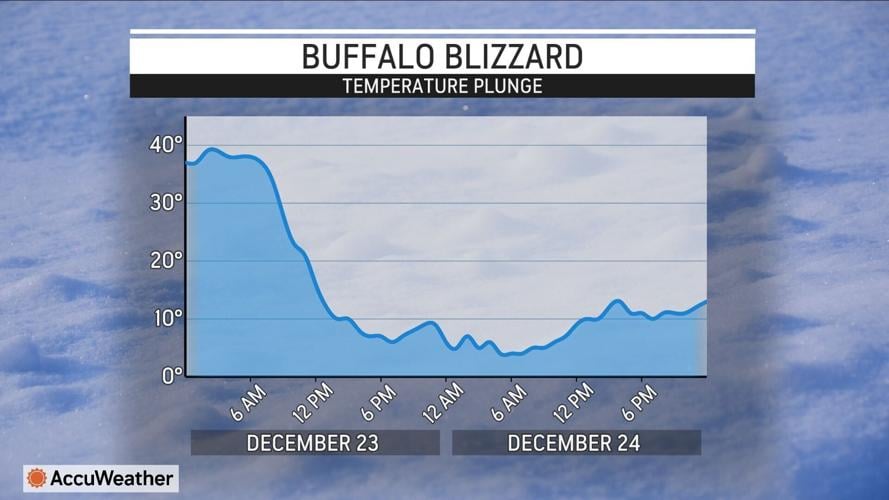
6 a.m. – It was 38 degrees at the airport as the storm moved in and the cold air wrapped around the back of it, pulling it into the Buffalo Niagara region, Sojda said. Rain turned to snow.
7 a.m. – Along with the temperature, the pressure within the storm began to drop. This can happen in a large storm, like a Nor'easter.
"It dropped 31 millibars from 7 a.m. Thursday to 7 a.m. Friday, which is what classifies it as a bomb cyclone," Sojda said.
"The storm is intensifying. You have upward motion around the storm that is rapidly increasing and it essentially creates a big cyclone-vaccum effect," he said.
7:54 a.m. – The Buffalo airport recorded 0.36 inches of snow had fallen by this point.
8:39 a.m. – This is when the blizzard began, the National Weather Service would later pinpoint. Blizzard conditions would not let up for 37 hours.
Poloncarz tweeted that a driving ban for the entire county would begin at 9:30 a.m. He also said that the Thruway, closed only at this point to commercial traffic, was now closed in both directions between the Hamburg and Eden/Angola exits after a camper apparently crashed into a utility pole, spilling power lines across the lanes.
Shortly after 9 a.m. the first power outages were reported, with close to 20,000 households and businesses in Erie County alone.
9:40 a.m. – A gust of 72 mph was recorded at the airport. That was just shy of a hurricane-force wind, Sojda said. A storm is categorized as a hurricane when sustained winds reach 74 mph. The blizzard wasn't a hurricane. "It's meteorologically different," Sojda said. "But what you feel at the surface is very similar."
10:10 a.m. – A 79 mph gust was reported in Lackawanna.
Noon – The temperature was down to 16 degrees at the airport, a 22-degree drop since 6 a.m.
Wegmans announced that all of its stores in Erie and Niagara counties would close at noon. Tops stores in the area would follow at 2 p.m.
12:30 p.m. – With zero visibility on the roads, the Erie County Department of Public Works started taking plows off the road.
Quick video of bad conditions are at our Emergency Operations Center. It is wickedly bad out now. Our @ErieCountyDPW is starting to pull plow trucks off the roads because they cannot see where they are going. pic.twitter.com/Er4SZDyReX
— Mark Poloncarz (@markpoloncarz) December 23, 2022
1:31 p.m. – Flooding from the Niagara River led Buffalo police to warn about Niagara and Tonawanda streets.
1:48 p.m. – The Thruway Authority announced that I-90 between Rochester and the Pennsylvania. border was closed to all traffic "due to deteriorating conditions and hazardous travel."
⚠️DO NOT TRAVEL: This is video from outside the Thruway's Buffalo Emergency Operations Center in #Cheektowaga. Blizzard conditions are making travel impossible. The NYS Thruway is closed from exit 46 to the PA line and all of I-190. Stay off the roads. #buffaloblizzard pic.twitter.com/YGq1uTArkj
— NYS Thruway Authority (@NYSThruway) December 23, 2022
A large section of I-190 was also closed. Other highways would follow.
3 p.m. – 8.1 inches of snow had fallen at the airport.
4:54 p.m. – Bitter cold sets in, with wind chills of minus-19 recorded at the airport.
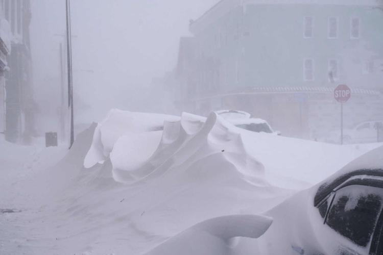
6:25 p.m. – The weather service revises its blizzard warning to say that snow accumulations "of 4 to 5 feet across the Buffalo Metro area, and 1 to 3 feet in surrounding areas" were now expected.
7 p.m. – 12.2 inches of snow at the airport.
8:54 p.m. – 16.8 inches of snow at the airport. Winds were gusting over 60 mph.
At the same time, Cassandra Garmon a single mother of two and pharmacy tech at Buffalo General Medical Center, posted a desperate message to the "Buffalo Blizzard 2022" Facebook group: "Help please. I'm stuck at Clinton and Babcock. Phone dying and I really need to get home to my kids. I have money."
She would remain in her car, the storm raging around her until 12:30 p.m. on Saturday, when a stranger on a snowmobile, after learning of her plea for help, came to rescue her and take her to a nearby shelter. She was one of hundreds of people who were stranded in their cars for hours.
SATURDAY, DEC. 24
2:36 a.m. – The National Weather Service updates its blizzard warning. Blizzard conditions were forecast to last until Saturday night. "Total snow accumulations of 2 to 3 feet with locally higher amounts possible. Winds gusting as high as 65 to 70 mph today and tonight. ... Wind chills as cold as 10 to 20 below zero."
6:37 a.m. – Sha'Kyra Aughtry heard the cries of Joey White, a 64-year-old developmentally disabled man, outside her home in the LaSalle neighborhood of Buffalo. She could barely see him in the heavy snow that was blowing sideways. Her boyfriend went out and carried him into the house. White had frostbite on his hands and was in dire need of medical help. But first responders couldn't come, and Aughtry took care of White until Sunday night when good Samaritans heard her plea on Facebook Live and took them both to Erie County Medical Center.
7 a.m. – 27.1 inches of snow had accumulated since Friday morning at the airport.
9:53 a.m. – With a lake-effect snow band entrenched over Buffalo and the Northtowns and blizzard conditions continuing, the weather service updates its warning, calling the conditions "life-threatening."
Winds were gusting to 55 mph, still strong, and wind chills as cold as 25 below zero were forecast.
4 p.m. – The first fatalities of the storm are reported. Poloncarz said three people, two in Cheektowaga and one in Buffalo, had died in the blizzard. The total would eventually rise to 39 in Erie County and one death in Niagara County.
9 p.m. – 34.6 inches had accumulated since Friday morning at the airport.
A woman carrying a roughly 10-month-old infant showed up at Erie County Medical Center's main entrance. As staff rushed to provide them care, the woman had urgent news to share: She told caregivers there were more people outside on Grider Street, trying to get into the hospital.
Frontline caregivers, wearing their scrubs, rushed into the blizzard to help four adults and a child who had lost power in their home. By Christmas Day, ECMC said it had about 150 civilians inside its hospital who had sought shelter from the blizzard.
10 p.m. – The winds finally wound down below 35 mph. After 37 hours, the blizzard was technically over.
But the emergency situation was far from over, and the death and destruction the blizzard wrought was only beginning to come to light.
Heavy lake-effect snow was still falling and winds were still causing whiteouts.
SUNDAY, DEC. 25
5:45 a.m. – The weather service replaces its "blizzard warning" with a "winter storm warning." Additional accumulations of 1 to 2 feet of lake-effect snow were forecast with winds gusting as high as 40 mph.
6:55 a.m. – 43 inches of snow had accumulated at the airport since the storm began.
9 a.m. – Poloncarz said that on Christmas morning, there were 26,000 households in Erie County with no power, with 20,000 of them in the City of Buffalo. National Grid would later say that 108,000 of its customers in Western New York lost power at some point during the storm.
7:02 p.m. – The weather service forecasted more heavy lake-effect snow, with an additional 7 to 14 inches.
MONDAY, DEC. 26
3:41 a.m. – The winter weather warning is replaced by an "advisory." Yet more snow was forecast, another 6 to 12 more inches in the most persistent snows.
10 a.m. – 49.2 inches of snow at the airport.
TUESDAY, DEC 27
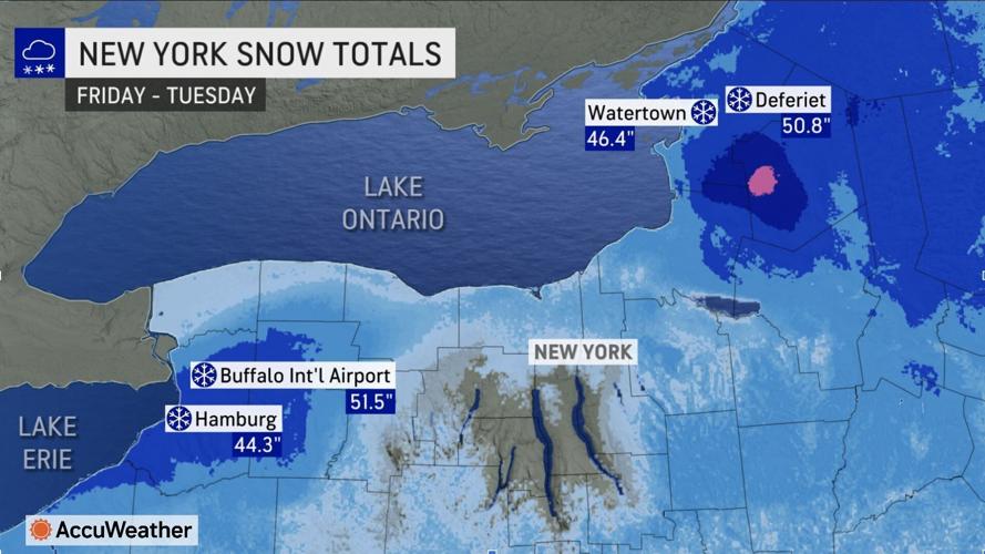
7 a.m. – 51.5 inches of snow at the airport.


