

The north side of Tucson is known for grandly scenic trails slicing into canyons of the Catalina Mountains.
The east side is known for a wondrous maze of trails in Saguaro National Park. The west side is is known for splendid paths in the Sweetwater Preserve and Saguaro Park's west unit.
But the south side? It was long known for its lack of nearby trails.
That's changing with a new 1,000-acre network of trails for hikers, mountain bikers and horseback riders.
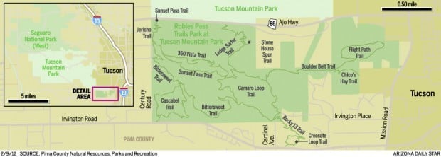
Pima County's Robles Pass Trails Park - at the southern end of Tucson Mountain Park between Ajo Way and Irvington Road - features 13 interconnected trails totaling 16 miles.
"Putting a trails park in that part of the community was a natural," said Steve Anderson of the Pima County Natural Resources, Parks and Recreation Department.
People are also reading…
"We've already got Sweetwater Preserve on the northwest side and Fantasy Island on the east side," Anderson said. "Now we've got a great trails park on the southwest side, and people love it."
The trails, which traverse saguaro-studded hills and rocky ridges, have been under construction over the past few years. Signs showing trail routes were installed at various points along the trails recently, but completion of trailhead facilities awaits additional funding.
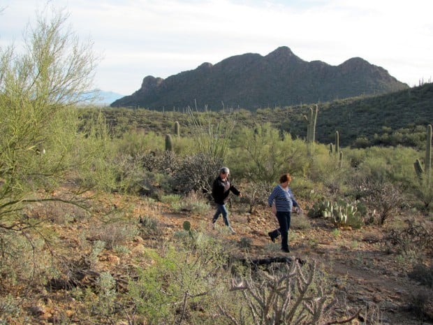
Hikers, cyclists or horseback riders can enjoy good views and a workout on one of the many possible loop routes in the park.
Sonoran Desert vegetation lines the trails - often framing distant views of craggy Cat Mountain to the northwest and Mount Wrightson in the Santa Rita Mountains 40 miles south of Tucson.
trail talk
Here are comments from some users of the Robles Pass trails:
• "It's beautiful out here. We live nearby, and it's nice to have something so close and so beautiful."
- Hiker Dave Lenning
• "Robles is a great addition to the Tucson region trail system that makes this area quite the awesome place to ride. It's appropriate for most riding levels, yet newer riders may find the rocks challenging."
- Mountain biker Martha Lemen
find the trails
• Several trailheads provide access to the Robles Pass Trails Park, but signs aren't yet in place to mark them.
• To reach one of the trailheads, follow Irvington Road west of Cardinal Avenue and watch for a small unpaved pullout on the north side of Irvington west of Mesquite Hills Place. A loop trail begins there.
• For another trailhead, take Ajo Way about three miles west of Mission Road and turn south on Bilbray Avenue. Follow Bilbray to Coyote Ridge Trail and go east on Coyote Ridge to an unsigned trailhead.
• Go to www.pima.gov/nrpr/parks/tmp/RPPA_trails_miles_letter.pdf to view a color map showing the trails and trailheads
Contact reporter Doug Kreutz at dkreutz@azstarnet.com or at 573-4192


 Tucson-born restauranteur Sam Fox leaves namesake company


