

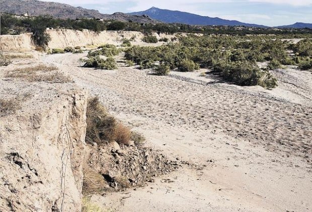

The Pantano Wash has taken a 30-foot bite out of Bill Pryde's land, and he's afraid he'll lose a lot more unless the county "lets the wash go where it wants to go."
Pryde wants the county to remove an approximately 200-foot-long, 20-foot-high berm on the south bank of the Pantano because he believes it is diverting floodwater and accelerating erosion on the north bank — where his land lies.
"It's not only done damage to my property but also state land next door," he said.
Officials with the Pima County Regional Flood Control District say it's not that simple.
They doubt that the berm about a mile east of South Houghton Road is forcing floodwater to the north bank.
"The direction of the wash has not changed," said Suzanne Shields, director of the Pima County Regional Flood Control District. "It's always headed pretty much to the north side of the bank.
People are also reading…
"All of our aerials (photos) going back to the 1970s show the channel in the same location as today," she said. "I know he does not agree with that. But erosion does occur."
Shields said it's not clear what would happen if the county removed the berm — or diversion dam, as some call it. Decades of sand and gravel mining and other projects in and around the wash have changed the way floodwaters roar through after heavy downpours.
"It's very difficult to change things around at this point," she said. "The river hasn't had a chance to heal itself from all the sand and gravel operations that have been in there."
Viewpoints differ
Pryde, a 73-year-old retired Air Force officer, sees it differently.
He believes that if the dam were removed, floodwater would flow into a big gravel pit on the south side of the wash, reducing the flow in the channel along the north side.
The pit was dug over many years by several firms that ran sand and gravel operations there.
Shields said the berm was built in 1990 by the Ashton Co., a big Tucson-based construction firm, after a flood filled the gravel pit.
Brian Andrews, a project manager with the Ashton Co., said his company worked a pit in that area in the early 1980s. But company records don't say anything about building the berm, he said.
Shields said the county bought 196 acres that included the old pit in 1993 for $850,000 under the Floodprone Land Acquisition program.
Pryde knew when he bought his 13.6 acres 10 years ago that the wash's channel ran along the north bank of the wash and that erosion would occur there. So he used the 1.5 acres of his land that lies in the wash for a sand and gravel operation.
A few years ago, he noticed that the north bank seemed to be eroding more quickly.
"I didn't pay much attention to it until maybe four years ago, when I noticed it and said to myself, 'What's going on here? I'm losing my land!' " he said.
Pryde, who has flown over and photographed the area many times, said it became obvious to him that the berm was aggravating the erosion problem.
During a recent hike in the wash, he showed a couple of visitors how erosion had cut away about 30 feet of his land, leaving fence dangling off the edge of the bank, maybe 15 feet above the floor of the wash.
Then he pointed to some wooden poles on state land just to the east, about 20 feet from the edge, saying, "See that power line? It won't be there much longer."
Seeking answers
Early last year, Pryde started trying to get answers from flood-control-district officials, but it took months of repeated efforts.
He also notified the State Land Department about the problem because erosion also was cutting into the 47-acre state trust land parcel just east of his property.
Jamie Hogue, the department's deputy commissioner, said Friday that agency officials have talked with Pryde and are looking into the matter.
"We take these types of issues very seriously and will do our best to assist in any way we can," Hogue said in an e-mail.
Pryde thought he had made a breakthrough in the summer of 2006 when the county brought heavy equipment into the area to trim off a portion of the berm.
"They sent a bulldozer out and they moved some dirt around, but it didn't do any good," Pryde said. "I think they did that just to placate me."
Shields said in an e-mail that the earthmover cut several feet into a 50-foot stretch of the berm "to allow flows to enter the former pit in a controlled fashion."
"We were trying to work with Mr. Pryde," she wrote. "We cannot work in the channel without permits, so we did what we could."
Consulting lawyer
Pryde said the agency's slow response and reluctance to answer his questions over the past two years have only irritated him further. He said he's talking with a lawyer about where to go from here.
He's now awaiting a report from a flood-control-district official who looked into the issue last month.
Shields said her staff has talked with Pryde many times over the past year and a half. She thinks at least some of his frustration comes from their differing conclusions.
"I'm not sure that it's mainly because we haven't given him the answer he wants," she said.
Shields said Pryde could be eligible for the Floodprone Land Acquisition program but not this year, because the county already has paid out as much as it can afford, after the flood-heavy 2006 monsoon.
Pryde said he'd sell the land "if they offered me the right price." But he'd prefer to stay on the property where he and his wife and son live — without the dam.
"I'd just like the county to let the wash go where it wants to go."
For more information
To find out whether your land — or prospective land — is in a flood-prone area, call the Pima County Flood Control District at 243-1800. The Web address is www.rfcd.pima.gov.


