

The federal government has accepted a plan proposed by Arizona, California and Nevada that will cut Arizona's Colorado River supply by 31% over the next two years, the Los Angeles Times reports.
Chris Avery, an assistant city attorney for Tucson Water, on Friday morning essentially confirmed the numbers reported by the Times on Thursday.
The plan that was reportedly accepted by the federal government also calls for California to take a 12% cut in its river water supply and for Nevada to take a 28% cut, the Times reports. The Times' story quoted anonymous state and local officials as having provided those numbers and said they spoke on condition their names not be used because details of a federal announcement are still being finalized.
Avery said that while those numbers may not be the exact amounts that will be cut, they are "recognizable" as very similar to, if not identical to, the proposal by the Lower Colorado River Basin states of Arizona, California and Nevada.
People are also reading…
California's cut apparently will be much smaller than those to be taken by the other two states, percentagewise, because it has a much larger Colorado River allocation than they do — 4.4 million acre-feet compared to 2.8 million for Arizona and 300,000 for Nevada.
The overall cut to Arizona's Colorado River supplies will translate to cuts in deliveries by the Central Arizona Project by 14% annually to cities and 10% annually to tribes, Arizona water officials have said. The CAP is the only major source of drinking water for Tucson today, and is a prime drinking water source for Phoenix.
A 14% cut in CAP deliveries to Tucson wouldn't affect the city's ability to meet its customers' demands for drinking water. That's because the city now receives at least 40% more CAP water every year than it currently uses. That excess in supply is more than enough for the city to absorb a 14% cut without the cut biting existing residents and businesses.
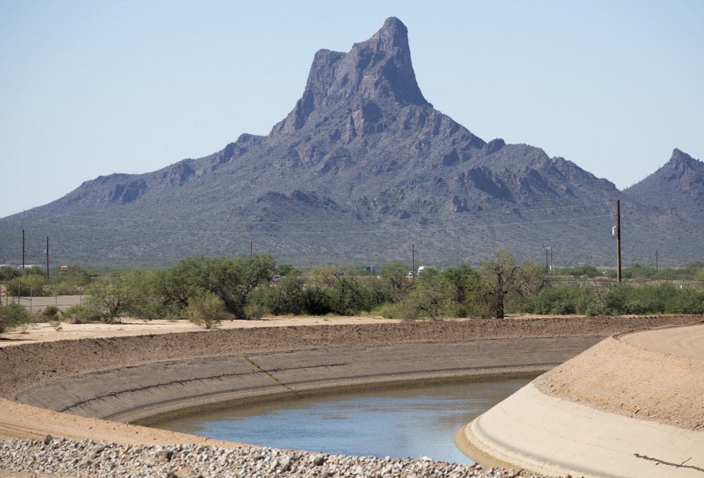
The Central Arizona Project canal carries Colorado River past Picacho Peak on its way to Tucson to be used for drinking.
The cuts are far smaller than possible reductions that the U.S. Bureau of Reclamation first floated publicly in its draft environmental impact statement on the river in January.
Those proposals could have cut supplies for the CAP by 77% or maybe even 98%, which CAP officials said would essentially take the project "off the map."
News of the planned cuts comes as the Bureau of Reclamation prepares to release a final environmental impact statement on the river that is expected to outline its proposed cuts in water deliveries.
The bureau will be trying to at least reduce if not eliminate a massive deficit between the river's annual flows and the amount of river water that cities, businesses, farms and tribes take from it.
That deficit has led to continued, steady declines in water levels at the river's two main reservoirs, Lake Mead at the Arizona-Nevada border and Lake Powell at the Arizona-Utah border.
Both have fallen low enough that they are considered to be in danger by sometime next year of falling below the levels at which Hoover Dam at Mead and Glen Canyon Dam at Powell could continue to generate electricity.
Beyond that is the threat of "dead pool" at the reservoirs, in which their water levels would fall low enough that it would no longer be possible to release water from them downstream to cities and farms. Both reservoirs today stand more than 100 feet above their dead pool levels, but various researchers and government officials have acknowledged that the risk of the reservoirs eventually hitting "dead pool" levels is real.
The Bureau of Reclamation didn't immediately respond to a request from the Star to confirm the levels of cuts reported by the Times and confirmed by Avery.
Photos: The receding waters of Lake Powell, Glen Canyon National Recreation Area

Tom Wright hikes past the beached marker for Willow Canyon where it joins with the Escalante River, Glen Canyon National Recreation Area, Utah.

A big horn sheep stands with the moon as a backdrop, looking over Fiftymile Creek, Glen Canyon National Recreation Area, Utah.
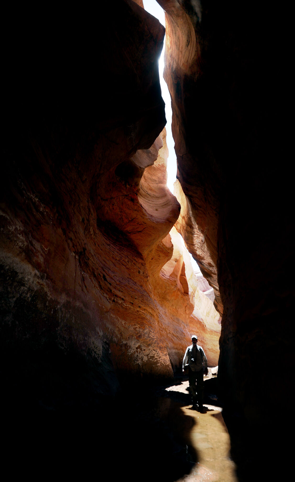
Tom Wright walks through the shaft of light peeking through the narrow openings of the formation called the Subway in Fiftymile Creek, accessible since the waters of Lake Powell have fallen dramatically.

A narrow sliver of sky is visible overhead through the narrow opening of the formation called the Subway, Fiftymile Creek, accessible since the waters of Lake Powell have fallen dramatically.

The dark streaking, called Desert Varnish, is from the seepage of oxidation in the rocks, and is beginning to erase the "bathtub ring", the lighter colored marks left by the waters of Lake Powell on canyon walls, Fiftymile Creek, Glen Canyon National Recreation Area, Utah.

The remains of a small boat, underwater for years, reemerges due to receding water levels of Lake Powell in the Glen Canyon National Recreation Area, Utah.
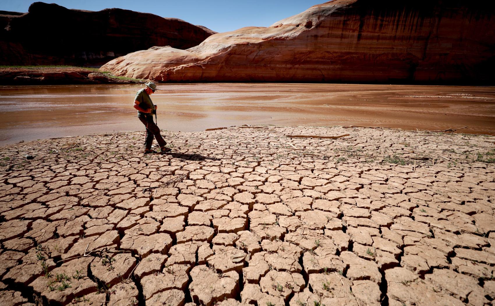
Frank Colver makes his way over the dried and cracking silt left where the Escalante River joins Lake Powell, Glen Canyon National Recreation Area, Utah. The receding water of the lake has the river cutting through the decades of accumulated silt to form a delta where it meets the lake.

A warning buoy sits high and dry far from the end of the closed public boat ramp at Bullfrog Bay, Glen Canyon National Recreation Area.

A line of tires that were once breakwaters at Bullfrog Bay Marina are now stranded on the rocky landscape high above the current water levels at the Glen Canyon National Recreation Area, Utah.
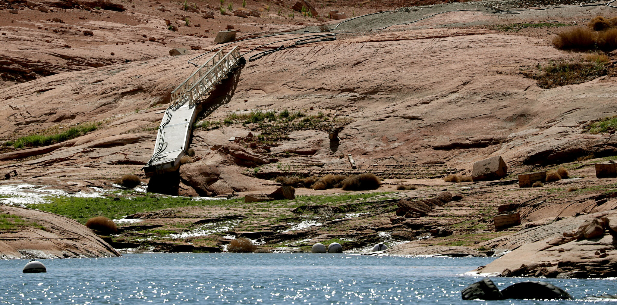
A pedestrian ramp lies well above the water levels at Bullfrog Bay in the Glen Canyon National Recreation Area, Utah.

A stranded wakeless zone buoy sits on the cracking silt outside the new shores of the Bullfrog Bay Marina, Glen Canyon National Recreation Area, Utah.

The end of the ferry ramp ends well short of the new water levels of Bullfrog Bay on the Glen Canyon National Recreation Area, Utah.

An early riser watches the sun come over the low waters of Bullfrog Bay Marina, Glen Canyon National Recreation Aria, Utah. The lighter colored areas on the canyon wall mark previous water levels.

A group of river rafters drift west on the current of the San Juan River outside Mexican Hat. The San Juan feeds Lake Powell.

The tops of a few cottonwood trees begin to poke out of shrunken water of Lake Powell, Fiftymile Creek, Glen Canyon National Recreation Area, Utah.

The remaining large water craft and house boats are crowded together in one of the last areas of water deep enough to support them at Wahweap Mariana, Glen Canyon National Recreation Area, Page, Ariz.

The waters of Lake Powell are twenty to thirty feet below the end of the public boat ramp at Wahweap Mariana, Glen Canyon National Recreation Area, Page, Ariz. Personal non-powered craft still use the ramp to unload, but must be carried up and down the banks to reach the water.

A view north from the Wahweap Marina Overlook show the shrunken waters around the marina in Glen Canyon National Recreation Area, Page, Ariz.

The underside of Gregory Natural Bridge, passable for the first time in almost 50 years, over the Fiftymile Creek, Glen Canyon National Recreation Area, Utah.

The moon rises over Gregory Natural Bridge, passable for the first time in almost 50 years, over the Fiftymile Creek, Glen Canyon National Recreation Area, Utah.

The exposed penstocks (intakes to the power turbines) on Glen Canyon Dam in the Glen Canyon National Recreation Area, Page, Ariz. The water level is at its lowest since 1967, when the dam was still being initially filled.

A group of sightseers get a look at the Glen Canyon Dam during a boat tour of Lake Powell, Glen Canyon National Recreation Area, Page, Ariz.

A small fishing boat ties up on the breakwater just outside the intakes for the Glen Canyon Dam, Glen Canyon National Recreation Area, Page, Ariz.. The penstocks (water intakes to the power turbines) are revealed for the first time since 1967 when the Lake Powell was being filled.

Swimmers and bathers use the jagged shores of the newly exposed banks of Lake Powell just above the Glen Canyon Dam, Glen Canyon National Recreation Area, Page, Ariz.

The Glen Canyon Bridge lies in front of electrical towers with feeder lines rising from the hydroelectric plant in the Glen Canyon Dam, Page, Ariz.

Glen Canyon Dam from Glen Canyon Bridge, Page, Ariz.

Small power boats on the Colorado River head upstream just below the Glen Canyon Dam, Page, Ariz.

Wade Quilter walks through the remains of cottonwood and Russian olive trees washed down and joined with silt to form a natural dam where Willow Canyon joins with the Escalante River, Glen Canyon National Recreation Area, Utah,

The remains of a big mouth bass lay in the silt just above where the Escalante River joins Lake Powell, Glen Canyon National Recreation Area, Utah.

The formation known as The Cathedral in the Desert on Clear Creek, Glen Canyon National Recreation Area, Utah. The re-emergence of the formation is drawing sightseers after being submerged for some 50 years.

Tom Wright feels the water oozing from the rocks in the formation known as Cathedral in the Desert on Clear Creek, Glen Canyon National Recreation Area, Utah. The re-emergence of the formation is drawing sightseers after being submerged for some 50 years.

Frank Colver takes a quiet moment and plays a handmade flute near the waterfall in the formation known as Cathedral in the Desert on Clear Creek, Glen Canyon National Recreation Area, Utah. The re-emergence of the formation is drawing sightseers after being submerged for some 50 years.

Jake Quilter walks down the newly cut banks of Clear Creek just outside Cathedral in the Desert, Glen Canyon National Recreation Area Utah. The sand is silt left behind by the receding waters of Lake Powell.

The tops of cottonwood trees that used to be under a hundred feet of water in Lake Powell are visible again in Clear Creek, Glen Canyon National Recreation Area, Utah. The deep water preserved the remains of the trees.

Boaters have to zig-zag through the rocks emerging due to receding waters of Lake Powell, Glen Canyon National Recreation Area, Page, Ariz.

Several images combined for a panoramic view of the Colorado River where it runs through the what once was Hite Marina in the Glen Canyon National Recreation Area, Utah.

A couple of sightseers take in the view from Hite Overlook over the Colorado River and the closed Hite Marina, Glen Canyon National Recreation Area, Utah.

Lone Rock, jutting out of the dry bed, would usually be surrounded by Lake Powell but is now well clear of the water, Glen Canyon National Recreation Area, Utah.

Tires that used to hold the lines well below the surface of Lake Powell are suspended over the water at Antelope Point Marina, Ariz.

Sightseers twenty or thirty feet above get photos of the low water levels of Lake Powell from the public boat ramp at Antelope Point Marina, Ariz.

The pedestrian access ramp ends abruptly twenty feet over the new Lake Powell surface at Antelope Point Marina, Ariz.

The entrance to the pedestrian access ramp of the Antelope Point Marina is taped off after being cutoff from the docks due to receding waters of Lake Powell.
 Colorado River reckoning: Not enough water
For Star subscribers: The water delivery system that 40 million people in the U.S. West depend on is at risk of collapse as the Colorado River shrinks.

For Star subscribers: Western water management system may be in the early stages of collapse.

For Star subscribers: To critics, Glen Canyon Dam was one of the U.S.'s biggest environmental mistakes. But it generates electricity for about 5 million people in seven states.

For Star subscribers: Without curbs in water use, Lake Powell seems likely to keep falling, squeezing a multi-billion-dollar recreation economy already damaged by the pandemic.

For Star subscribers: Debate over how to manage Lake Powell rages on as environmentalists prepare for when Lake Powell drops too low to deliver water.

For Star subscribers: As bad as conditions are today, they could get worse as hotter, drier conditions in the west intensify.

For Star subscribers: Expect to pay more for water and food, install low-flow toilets and drink treated wastewater.
Contact Tony Davis at 520-349-0350 or tdavis@tucson.com. Follow Davis on Twitter@tonydavis987.

Tony Davis
Reporter


