7 Day Forecast
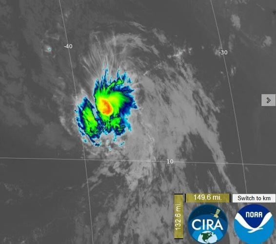
Tropical Storm Dolly has formed in the Atlantic, just days after music icon Dolly Parton's death, becoming the fourth named storm of the 2026 Atlantic hurricane season.
Dolly, the storm, formed at 11 a.m. EDT on Thursday, the National Hurricane Center said.
Forecasters said the system is expected to be short-lived because of hostile environmental conditions starting on Friday that will prevent it from developing further. In an afternoon online forecast discussion, the hurricane center said that "global and regional models all show Dolly degenerating into a strong tropical wave on Friday [Aug. 28] or Saturday [Aug. 29] before it reaches the Leeward Islands, and our forecast shows this decay by the weekend."

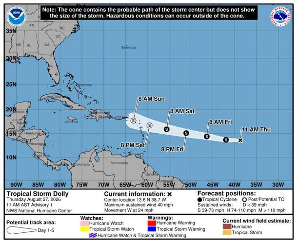
Tropical Storm Dolly formed on Aug. 27, roughly 1,500 miles east of the Windward Islands. It's forecast to pass near the Leeward Islands and approach the Virgin Islands, Puerto Rico and Hispaniola with heavy rain and potential flash flooding, whether it remains a tropical storm or not.
Dolly's formation came after becoming better organized overnight, the hurricane center said on Thursday.
The name of the storm has nothing to do with the death of Parton on Aug. 25; the names of storms in the Atlantic and eastern Pacific come from a decades-old alphabetical list that is repeated every six years and is maintained by a committee of the World Meteorological Organization in Switzerland.
People are also reading…
According to the hurricane center, the name Dolly replaced Diana after the 1990 hurricane season and was first used in 1996.
It's an "astounding coincidence," retired National Oceanic and Atmospheric Administration meteorologist and Parton fan Roger Edwards said.

Tropical Storm Dolly has formed in the Atlantic Ocean, midway between Africa and the Windward Islands. The peak period for tropical activity in the Atlantic began in mid-August and extends through mid-October. Dolly is forecast to be a short-lived storm, as it faces unfriendly conditions.
Where is Tropical Storm Dolly?
As of 5 p.m. EDT on Thursday, Dolly was about 1,425 miles east of the Leeward Islands of the Caribbean and was moving to the west at 24 mph.
Its maximum sustained winds were 40 mph.
In a forecast discussion, the hurricane center said that "although Dolly is forecast to no longer be a tropical cyclone when it passes near the Leeward Islands, heavy rainfall could begin to affect the Leeward Islands late Saturday [Aug. 29] into Sunday [Aug. 30] and the Virgin Islands, Puerto Rico and Hispaniola Sunday [Aug. 30] and Monday [Aug. 31]. This heavy rain may produce flash flooding, especially in areas of higher terrain."
Could Dolly impact the mainland US?
AccuWeather meteorologists note that conditions in the Atlantic this hurricane season have prevented tropical storm growth. If the storm can stay together long enough, it could be worth monitoring for those along the East Coast, AccuWeather lead hurricane expert Alex DaSilva said in an email on Wednesday, before Dolly was named.
If Dolly remains a weak tropical storm, it could pose a concern to the Bahamas and possibly the mainland United States, AccuWeather reported. But if it strengthens, it could turn northward and head out to sea, with its impacts missing the mainland United States, according to DaSilva.