

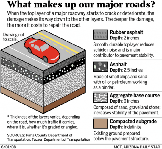
About 13 percent of the major roads in and around Tucson are in such bad condition that repaving in not an option. The only real fix is to tear them out and rebuild from the ground up.
In odometer talk, that's like driving over 481 miles — roughly from Tucson to Los Angeles — on a continuous ribbon of bumps, ruts, cracks, holes and waves.
If you break it down, nearly 23 percent of Pima County roads are nearing the end of their serviceable life. The overall average is tempered by just 5 percent of city of Tucson streets being in such run-down condition, based on data collected by a regional pavement-monitoring system.
And the county figures don't even include the deterioration of neighborhood streets, which it hasn't gotten around to measuring yet, as Tucson has.
When roads get that bad, filling potholes and sealing cracks at the surface aren't enough to save them. Not when the roadbed underneath is crumbling due to heat; rain seeping into cracks and expanding when it freezes; the weight of thousands of cars passing over; and years of neglect.
People are also reading…
When roads are that far gone, total replacement, at a cost of up to $47 a square yard, is the only answer.
Where are all these bad roads? Anybody who has a driver's license probably already has his or her personal favorite — if you want to call it that. But does your Highway From Hades really measure up?
To save you from burning a lot of $3.68-a-gallon gasoline finding out, we took to the road ourselves to find the worst of the worst.
How we did it
The city and county use a rating system based on sensors mounted in a van. The sensors measure the deterioration of the pavement as the van travels over the roads.
We limited our search to roads and streets that the city and county ranked "poor" or "failing" themselves.
And because one of the qualities that earn a bad road its reputation is how many drivers share in the suffering, we took into account how heavily traveled the road is. We didn't drive on dirt roads or neighborhood streets.
Even with those restrictions, we still traveled nearly 200 miles to personally inspect pavement conditions and feel the bumps and lumps firsthand.
We noted the overall pavement condition, how bumpy the ride was, whether we had to dodge ruts and potholes, and whether we had to slow down to feel safe.
Here's what we found. Disagree with our selections? Let us know by writing to gridlocked@azstarnet.com. We'll post some of your suggestions online on our traffic blog at go.azstarnet.com/gridlocked.
The six worst roads in the Tucson area
• 1. South Mission Road, south of West Los Reales Road to West Pima Mine Road: As an alternative route to Interstate 19 for drivers headed to the mines and residential areas west of Sahuarita, this road is the worst of the worst. The pavement is so deteriorated that you can easily see where it gets washed away with slight rainfall, and then gets patched. And then patched some more before it's patched again. To drive safely here, you must slow down to well below the speed limit.
• 2. North La Cañada Drive and North Flowing Wells Road, from West Magee Road to West Roger Road: This road that changes names — a major route from Oro Valley and unincorporated Pima County into Tucson — is very heavily traveled. The pavement surface is worn and uneven. It feels like driving on small rocks. This road offers a little of everything, with sealed and unsealed cracks crisscrossing the surface, potholes, small plateaus where the road surface has receded around a pothole patch, worn pavement and general bumpiness.
• 3. South Camino Loma Alta, East Old Spanish Trail to East Colossal Cave Road: The wavy pavement itself, not potholes, makes this road feel like a washboard. Many residents use this road as primary access.
• 4. South Campbell Avenue, East Benson Highway to East Valencia Road: Very large potholes and ruts running parallel to the direction of traffic can catch your tires if you're not careful. This is a busy road, providing access to neighborhoods, Tucson International Airport, Sunnyside High School and major industrial areas.
• Tied for 5 – North Mountain Avenue, from East Fort Lowell Road to East Roger Road: While this road isn't as heavily traveled as others, it borders some heavily populated neighborhoods and sports a lot of bicycle and pedestrian traffic. Patches of filled potholes mean bicyclists and drivers must pay close attention to make their way safely.
• Tied for 5 – South Wilmot Road, the paved portion south of Interstate 10: It provides access to several prisons and a growing residential area. As we traveled on this road, the bumps from perpendicular cracks jarred us several times every second. Development has started near here, and more may be on the way in the next housing boom. We were glad we didn't have any coffee in the cup holders, or it would have been splashing out.


