

A 2006 National Geographic-Roper Survey of Geographic Literacy found that only 37 percent of young adults could find Iraq on a map.
Apparently they didn't ask the students at Pusch Ridge Christian Academy.
Not only can the students find Iraq on a map, but they also can locate Denmark, Sudan, Afghanistan, the Gobi Desert and the Baltic Sea.
Freshman students are required to take an entire year of world geography that culminates with each student mapping the world entirely from memory.
The memory map was added to Pusch Ridge's curriculum by Jason Clapero in the fall of 2000 and has since become a rite of passage and a requirement for students at the school, 9500 N. Oracle Road.
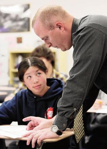
Clapero teaches honors geography and world history at the school.
People are also reading…
"Unless you have this framework of where something is, you can hear about it all you want," Clapero said. "If you have no idea where it is or the relative size, I think we have a hard time learning it. If they know where it is, it can start the process of learning other things, too."
Clapero devised his own memory map from curriculum developed by a Massachusetts teacher.
Preparation for the final project starts the first day of class, when Clapero asks his students to try to map the world from memory.
Examples from students indicate that they know little about the location and size of the world's seven continents. One map depicted Greenland as a circle.
"All I really knew was North America," freshman Alyssa Taylor, 15, said about her map. "I kind of made stuff up."
Clapero, 33, is not concerned with his students' lack of geographical awareness. He is amused.
"Of course they all are so patriotic, the U.S. is huge," Clapero said about those first maps. "They know their framework generally, but not much of the rest of the world."
To students like Taylor, the memory map is a daunting task, but with practice, doubts vanish.
At the end of each unit, the students are responsible for producing mini-maps on a different region of the world.
In addition to the mini-maps, Clapero requires his students to complete two 15-minute presentations on a different country. Students pair up for the presentations and act as country tour guides.
For a less-intense approach to the final project, Clapero and his students frequently play a geographic trivia game.
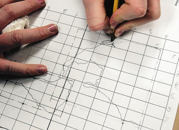
When it is time to draw the final map, students are only allowed to use a pencil, ruler, checklist and box of colored pencils to complete what is a two-week final exam.
The students begin by drawing a grid system, which makes it easier to find — or come close to — the location of a country or a body of water.
After outlining the continents, students are expected to mark country borders and to label countries, oceans, seas, gulfs, rivers, mountains and other features.
In all, students must identify more than 300 items on their maps. A checklist is provided so students know exactly what to include on their maps.
A select number of important cities, such as Kuala Lumpur, Warsaw and Hanoi, also must be marked on the maps.
When senior Becca Radtke, 17, took the course, she recalls panicking about the final project.
"I remember going home and freaking out about it," she said. "I think I cried about it actually."
Sophomore Josh Spegman, 16, said he learned far more than he anticipated from the task.
"It gave me an appreciation for how large the world is and how little I've actually been able to see in my life," Spegman said about successfully executing his map last year.
Now, he laughs about the first time he was asked to map the world.
"The original was blobs, circles and squares," Spegman said. "Paris was in the middle of Germany. The final one, you could actually tell where things were. You could see that it was the world."
Spegman's map is displayed in his bedroom.
Pusch Ridge Principal Eric Abrams has a map hanging in his family's entertainment room. His son Zach, who graduated last year, did the project when he was a freshman.
"We underplay and underestimate the role of geography in helping us be educated people and understanding the dynamic influences that affect us," Abrams said.
Abrams instituted the geography class at Pusch Ridge, but let Clapero select the curriculum.
Most public schools combine geography with world history and only require three social studies credits to graduate. Pusch Ridge requires four credits.
Neither Abrams nor Clapero expect to discontinue the map anytime soon.
"It's pretty amazing to watch," Clapero said about the progress over the years. "I've had to adjust my grades. What was an A map the first year, is probably a C map now. They take it real seriously."
Though she will have to wait a couple of months, Taylor, a freshman in Clapero's honors geography, is anxious about starting on the map.
"I am looking forward to when it's over," she said. "Not (to) doing it."
The original was blobs, circles and squares. Paris was in the middle of Germany. The final one, you could actually tell where things were."
Josh Spegman
Pusch Ridge sophomore


