

A common theme in Bureau of Land Management memos about the Rosemont Mine is that the Forest Service didn’t do enough to understand the faults and fractures underneath the mine site.
Bureau scientists warned in several memos that the fractures and faults could act as conduits, allowing groundwater to flow more rapidly than it would otherwise from Cienega Creek to the mine pit, and making it more likely that the creek could dry up.
The Forest Service has been steadfast in its view the fractures and faults aren’t a big deal. In its final Rosemont Environmental Impact Statement, the service concluded that its computer models already take into account known faults and fracture zones. It said criticism of the models was “not sufficient to demonstrate the existence of significant faults that have not been considered.”
“This was raised as an issue early on, and we convened a science panel that included scientists from the Arizona Geological Survey. I wanted to know what’s going on,” former Coronado National Forest Supervisor Jim Upchurch said in a recent interview.
People are also reading…
“The drilling that was done for the computer models and the ore bodies didn’t pick up any fracture geology,” said Upchurch, now an assistant Southwest regional forester in Albuquerque.
But in a December 2013 memo, BLM biologist Jeff Simms warned of vast uncertainty about what will happen to the bedrock after mining begins. He consulted with BLM hydrologist Ben Lomeli and with BLM geologist Dan Moore on the memo.
“The principle of using a scientific approach was sacrificed for expediency,” Simms wrote. He added that the Forest Service needs to collect more data about the faults and fractures, one method being drilling more wells deep underground.
Most of the mine’s open pit would be completed in faulted and fractured bedrock, Rosemont’s environmental impact statement says. Groundwater flow in that area occurs almost exclusively through fractures and faults, Simms said, but the Forest Service is treating the aquifer as if it were a homogeneous medium.
In his view, that’s a bad call because the computer modelers “have no way of knowing to what degree the faults and fractures affect the average rate of movement of groundwater” without visiting the site.
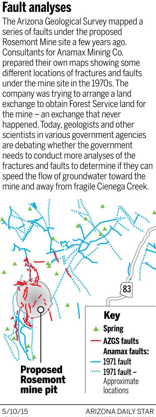
Both Pima County, which opposes the mine, and the Arizona State Parks Department raised similar concerns after seeing earlier drafts of Rosemont environmental impact statements. In part, the county based its position on a report done in the mid-1970s for the now-defunct Anamax Mining Co., which was trying to secure Forest Service land for a Rosemont Mine through a land exchange that never succeeded.
The report and accompanying map, done by Anamax consultants, concluded the Rosemont area’s major structural feature is a fault running along its west side, with another in the southwest corner. The area also has two major sets of fractures, which are associated with numerous springs “and serve as conduits for the storage and movement of groundwater,” the Anamax report said.
Anamax eventually abandoned the plan due to financial issues, including a sharp decline in copper prices that started in the early 1980s.
The report drew skepticism from Lee Allison, director of the Arizona Geological Survey. Allison noted that a team of geologists from his office went to the mine site and mapped a series of faults in 2007. While the state geological survey map showed far fewer faults than the earlier Anamax map — and didn’t map fractures at all — Allison said he believed his agency’s map was more precise and at a higher resolution, and that many faults shown on the Anamax map don’t exist.
He said nothing in the geological society’s work indicates more study is needed.
Looking at the fracture issue more generally, retired U.S.G.S. hydrologist Stan Leake said the drilling and pump-testing of wells on both sides of a fracture or fault can determine if it’s having an impact on groundwater levels or flow. If water levels are different on both sides, that’s solid evidence the fracture is having an effect, he said.
But understanding the significance of fractures is an expensive proposition, considering the costs of drilling wells and monitoring water levels, he said. After testing one fracture site, “you may have to look at other sites and see if they behave the same,” said Leake, who still works for U.S.G.S. as a volunteer.
Contact reporter Tony Davis at tdavis@azstarnet.com or 806-7746. On Twitter: tonydavis987.

Tony Davis
Reporter


