

The 2024 Atlantic Hurricane Season starts June 1 and that means a new list of storm names you could see this year.
The names encompass almost every letter of the alphabet with the exceptions of Q, U, X, Y and Z.
This year's primary list is largely borrowed from 2018's. Storm names rotate every six years dating back to 1979. However, storms that were particularly destructive and deadly may be retired if the World Meteorological Organization, an agency of the United Nations, votes to do so.
Florence and Michael were retired from the 2018 list. In it's place for 2024 are Francine and Milton, respectively.
The World Meteorological Organization also names storms for other parts of the world as well.
People are also reading…
2024 Atlantic hurricane basin Forecast
Colorado State University says this year has the most number of storms they've ever forecast in their 29 year history. In addition to their very active forecast comes a warning that a majority of the storms in the Atlantic hurricane basin, which includes the Gulf of Mexico and the Atlantic Ocean, will be near North America.
"We anticipate a well above-average probability for major hurricanes making landfall along the continental United States coastline and in the Caribbean," said Phil Klotzbach, senior research scientist at CSU and lead author of the forecast.
This year four states have a greater than 50% likelihood of a hurricane being within 50 miles of their coastline: Florida, Louisiana, North Carolina and Texas. On average, only Florida carries a risk that high each year.
The active forecast is due to the transition from an El Niño weather pattern to a La Niña during the summer and fall.
La Niña, Spanish for the girl, leads to hurricane-favorable conditions. During a La Niña, cooler than average water temperatures develop in the eastern tropical Pacific Ocean in the Southern Hemisphere, off the coast of Peru. As a result, in the tropical Atlantic Ocean, wind shear, a change of wind direction as height increases, weakens.
In addition, sea surface temperatures in the central and eastern Atlantic Ocean are at record warm levels. They are forecasted to stay well-above average during the June to November season.
Developing tropical storm need warm water and low-wind shear environments to form into powerful, threatening hurricanes. The warm water provides fuel, while the lack of wind change with height allows the storm to focus on strengthening, rather than fight the wind shear.
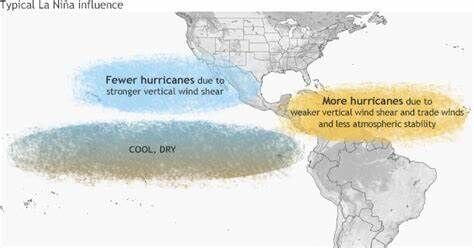
La Nina conditions lead to more favorable hurricane conditions in the tropical North Atlantic Ocean.
Atlantic hurricane basin's 2024 tropical cyclone names
Alberto
Beryl
Chris
Debby
Ernesto
Francine (Francine replaces Hurricane Florence, which was retired in 2018. Florence made landfall in North Carolina on Sept. 14 as a tropical storm. However, it hovered near the Carolinas for days prior, unleashing torrential rain and storm surge.)

In September 2018, Hurricane Florence stalled as it came ashore in the Cape Fear region, which caused extreme flooding. The North Carolina record for tropical rainfall was broken by the 35.93 inches that fell near Elizabethtown. This animation shows the position of the eye every 15 minutes on the morning of Sept. 14, 2018.
Gordon
Helene
Isaac
Joyce
Kirk
Leslie
Milton (Milton replaces 2018's Hurricane Michael, which was retired. Michael made landfall on Oct. 10 near Tyndall Air Force Base on the panhandle of Florida.)
Nadine
Oscar
Patty
Rafael
Sara
Tony
Valerie
William
What happens if all of those names are used?
If the National Hurricane Center wants to classify a tropical cyclone beyond William, a supplemental list of names are used.
These names have been in place since 2021. Before 2021, the Greek alphabet was used for additional storms. However, a very active 2020 Atlantic Hurricane Season and the Greek alphabet storm names led to confusion. The World Meteorological Organization ultimately swapped those names for this supplemental list.


