More than 95% of all precipitation that falls in Arizona ends up evaporating into the air from soil or plants that take up the water. Only 3% of our rainfall and snowfall ever finds its way into the state's often parched aquifers.
Those two realities form the backdrop for a new, state-financed report on groundwater recharge from researchers at the state's three major universities. It urges public officials to step up efforts to capture precipitation and encourage it to infiltrate through sands and gravels in the ground into our groundwater supply.

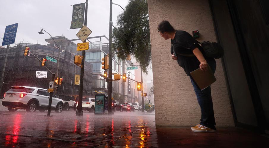
A pedestrian takes shelter in a downtown building’s overhang, hiding from Wednesday's downpour. A new study finds that only 3% of Arizona's precipitation ends up in aquifers.
The $3.7 million report concludes that carrying out even a small increase in the amount of water captured and recharged could cause significant increases in water supplies, although it didn't specify how much of an increase.
People are also reading…
And even modest reductions in the amount of water lost to evaporation "could translate into meaningful increases in water availability for direct use or recharge," says the report. It was done at the request of the Arizona Department of Resources and released after more than three years of research.
It says numerous opportunities exist across the state to increase the amount of recharge. Some ways of improving recharge — such as digging out and building large basins to capture storm runoff — are expensive.
But many others can be carried out at much less expense by incorporating recharge-friendly techniques into development practices and public construction projects, among other things, that are normally happening anyway, said Kathy Jacobs, a longtime University of Arizona climate scientist and the project's principal investigator.
“Given the current concerns about the reliability of Colorado River deliveries to Arizona, this is a critical time to be thoroughly exploring our water supply options,” said Jacobs, founder and just-retired director of UA's Center for Climate Adaptation Science and Solutions.
While increasing recharge isn't "a fundamental solution to all of our water supply problems, it's an incremental step forward, and in some cases a significant step forward," Jacobs said.
While touting the benefits of increased recharge and providing a long list of opportunities for doing that, the report also makes forceful warnings that our continually warming climate is reducing other available surface and groundwater supplies.
"Climatic factors can explain much of Arizona’s ... water storage declines since 2000," the report says, citing declines in both groundwater and surface water supplies. While that conclusion is based on computer modeling done for the study, it says the model's results are consistent with what's been reported from separate, satellite-based data.
While local groundwater pumping may dominate impacts to groundwater in specific areas, "climate impacts are likely the primary contributor statewide" to declines in stored water supplies, the report says.
Balancing water needs of humans and plants
The losses of water from our rains and snows are linked by the study to a phenomenon known as evapotranspiratoin, or ET for short. It covers two separate activities:direct evaporation pf water into the air from soil and water bodies, and transpiration, or the movement of water from soil into the atmosphere via plants.
And because a lot of the existing rainwater is now lost through plants, researchers have had to navigate a "tricky balance" between wanting to enhance groundwater recharge for human use with the need to protect and enhance the natural environment, said Professor Neha Gupta, a UA water researcher who has taken over the project's lead role upon Jacobs' retirement.
One key recommendation along those lines was for officials to increase the amount of "thinning" of overgrown vegetation in the states' forests. Removing some excess trees from such areas can reduce wildfire risks while increasing water supplies.
The highly detailed report has a statewide focus for how recharge can best be carried out. But Gupta made a point of noting that the big storm Wednesday evening in Tucson that toppled or otherwise damaged at least 25 power poles and required two swift-water rescues is the kind of extreme weather event that the report says are increasing and will continue to increase due to climate change.
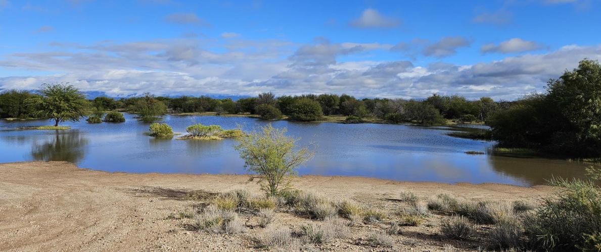
Gupta also cited a recent city-county project to build two giant detention trenches in the Rita Ranch area on Tucson's far southeast side as an example of the kind of projects that could be built statewide to improve recharge opportunities. The trenches, one 100-feet long, the other a U-shaped trench covering 230 feet total, were built in 2024 by the Pima County Regional Flood Control District.
Water flowing down a stream channel out of the Rita Ranch subdivision into a detention basin on the Tucson area's far southeast side to improve recharge opportunities. Pima County built trenches in the detention basin in 2024 to improve recharge of surface water into the groundwater table.
In the first four months the county monitored the trenches' water capture, from September through December 2025, only 3 inches of rain fell in that area. But about 23 acre-feet of water flowed into the trenches, said the flood control district. That's enough to supply nearly 100 Tucson-area homes with water for a full year.
Water in storage is declining
Some of the report's key conclusions:
- Warming is having a profound effect on the supply and behavior of water in Arizona. That includes increasing water losses to evapotranspiration, in which rainfall is ultimately taken up by plants, reducing soil moisture and decreasing recharge.
- Statewide, the total amount of water in storage is declining over time. At the same time, strong evidence exists that extreme events, including heat waves, drought, floods and wildfires, will increase in intensity in the future.
- The most significant water supply changes are occurring in mountainous areas and others dominated by snowpack, including reduced snowpack and earlier peak runoff. The earlier melted snows flow into rivers and streams, the less is available during hotter summer months.
And since late season snowmelt is one of the biggest factors in the amount of recharge that occurs, earlier runoff also means less water is recharged.
"You can think of snow on the ground as a reservoir supplying water to runoff and infiltration. The longer the snow melts, the more runoff and recharge there is, " said another researcher for the report, Professor Abe Springer of NAU's School of Earth and Sustainability
- Flood-related extremes may provide new opportunities as well as new challenges. Engaging flood control districts in partnerships to maximize capture and recharge of increased flows is one option that can be considered.
- Land management decisions at multiple scales can be adjusted to take advantage of a new framework proposed by the report. It involves practices such as integrating recharge considerations into fire management, road-building, land and infrastructure development, flood control and other resource management activities.
"Incorporation of recharge objectives in land management efforts and infrastructure design, particularly land development, management of flood flows, forest thinning, and fire management, can substantially contribute to water reliability in some areas."
- Thirty-two percent of Arizona's surface water flows originate as groundwater while surface water recharges groundwater basins in other areas.
"These fundamental aspects of water in Arizona are not well recognized by the public or by our existing legal system, which treats surface water and groundwater as if they were separable," the report says.
- Dry wells — wells that have no water but in which people inject water for groundwater storage — and detention basins appear to be much more effective at inducing infiltration than previously recognized. Dry wells are installed in detention basins and get water into underground aquifers quickly.
- The area of the state with the highest potential for generating large volumes of water for capture and storage is the Mogollon Rim, because of its significantly higher volumes of precipitation compared to evapotranspiration. The rim is a generally mountainous area, stretching in an arc from the Gila River on the south towards Flagstaff on the north.
The rim is a promising place for recharge because it contains a fair number of faults and fractures and limestone-based rock formations known as karst that are conductive to water movement and recharge, Jacobs said.
Forest thinning "a great option"
Overall, the researchers sought to balance their advocacy of reducing evapotranspiration of water with not being "anti-vegetation" and keeping broader environmental benefits in mind, to support overall watershed health and functioning, said Gupta.

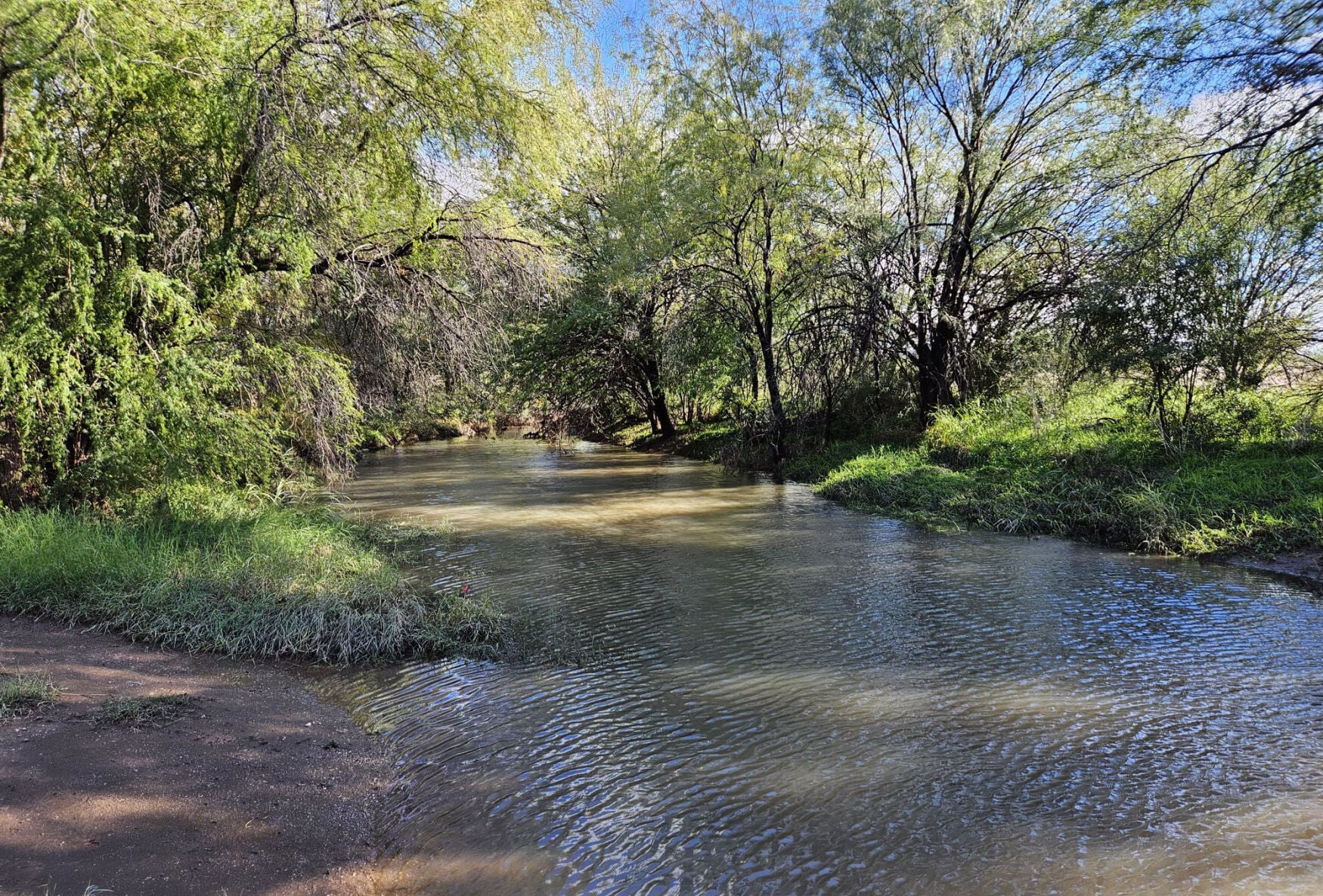
The Rita Ranch Detention Basin after a storm in January 2026. The detention basin is within the Rita Ranch subdivision on Tucson’s far southeast side. Trenches built inside the basin in 2024 increase recharge of water into the aquifer.
While acting to improve groundwater recharge, "We need to keep watershed functioning and health as a priority because maintaining our natural systems is a key component of an overall healthy water cycle," Gupta said. "Vegetation can play a key role in moderating local and regional hydrologic cycles so there is a 'sweet spot' to keep in mind."
The goal of increasing recharge must be balanced with consideration of other roles water plays in the landscape — "both potential impacts of increasing recharge at the expense of other water uses and potential benefits of recharge beyond human use."
"This project has explicitly focused on ways to enhance recharge without damaging (and hopefully supporting) natural systems and environmental health," the report says.
In conducting the study, the researchers were able to separate the impacts of pure evaporation from transpiration of water into plants, and included the resulting findings in the separate profiles they did of 51 groundwater basins across the state, Gupta said.
Nearly 55% of the statewide water loss is caused by evaporation from soils and leaves, the study found. About 45% is caused by plants taking up water from precipitation.
"That's why forest thinning was a great option — it reduces evapotranspiration and provides forest health benefits," Gupta said.
At the same time, the report notes that evapotranspiration also supports crop and vegetation productivity, cools land and water surfaces for people and wildlife, and supports fish and aquatic life where there is surface water.
Removal of vegetation does decrease transpiration of water, but it may increase evaporation, "so it has to be done carefully in order to avoid negative consequences."
To date, most artificial recharge in Arizona has been done mainly using Central Arizona Project supplies from the Colorado River and treated wastewater, not captured stormwater, as the new report calls for doing. And it's been done mainly in low-elevation, desert areas, mainly surrounding the Tucson and Phoenix metro areas.
"But there are areas across the state that have recharge potential that warrant additional consideration. At low elevations, generally high aridity and evaporative demand limit the amount of water that can be captured and recharged," the report says.
"But, there are significant management opportunities to enhance recharge in mid- to high-elevation forests, mountain fronts, and riparian areas. There is an abundance of opportunities across the state to provide ecosystem benefits through enhancing infiltration."
Asked to comment on the report, the Arizona Department of Water Resources said: "As prolonged drought conditions shape a hotter, drier future, ADWR is pleased to leverage the expertise of Arizona's three major universities through initiatives like (this) project to identify practical, science driven solutions to Arizona's increasingly complex water management challenges."
The agency declined to say, however, how it might make use of the report's findings, saying, "We're assessing the data and conclusions. It's too soon to say what happens with it down the road."
Both ADWR and the authors of the new report also paid tribute to the late hydrology professor Thomas Meixner, the initial principal investigator for the project. Head of UA's Hydrology and Atmospheric Sciences Department at the time, he was murdered on campus by an expelled former graduate student on Oct. 5, 2022, the day after he formally presented his project proposal to ADWR.
"Tom was a universally well-liked professor, a talented researcher, and a very collaborative person who loved working on applied projects. The team owes him a debt of gratitude for his initial ideas and teambuilding as well as the substantial contributions he made to water research, community initiatives, and collaboration in Southern Arizona," the report says.
“After we really tragically lost him, the team really decided that we also wanted to make sure to carry out this project as a great way to honor his legacy and everything that he did, and the type of researcher he was," Gupta told The Arizona Republic.
Photos: Monsoon 2026

A bolt of lightning strikes just southwest of Vail, Ariz., part of a monsoon storm cell that moved mostly around the greater Tucson area, July 9, 2026.

A lighting bolt and a downburst of heavy rain hits in the eastern reaches of the Santa Catalinas Foothills, part of several monsoon cells that hit sporadically around the valley, Tucson, Ariz., June 25, 2026.

Maximiliano Fimbres uses a chainsaw to cut through the trunk of a fallen tree at Michigan Street and S. Park Ave. in Tucson, Ariz. on June 18, 2026.

Power lines lay across S. Park Ave near Irvington Road in Tucson, Ariz. on June 18, 2026. A monsoon storm on Wednesday night brought heavy rains and wind to the south area of Tucson.

A worker looks back at the downed power lines laying across S. Park Ave near Irvington Road in Tucson, Ariz. on June 18, 2026. A monsoon storm on Wednesday night brought heavy rains and wind to the south area of Tucson.

Crews work on fixing multiple fallen power lines near East Ajo Way and Benson Highway after storm showers hit Tucson on Wednesday afternoon, June 18, 2026.

Multiple fallen power lines hang near East Ajo Way and Benson Highway after storm showers hit Tucson on Wednesday afternoon, June 18, 2026.

Crews work on fixing multiple fallen power lines near East Ajo Way and Benson Highway after storm showers hit Tucson on Wednesday afternoon, June 18, 2026.

A pair sprints to shelter as massive storm showers roll through Tohono Transit Center, Tucson Mall Drive, Tucson, Ariz., July 11, 2026.

A cyclist rides his bike to shelter minutes before storm showers roll through Tohono Transit Center, Tucson Mall Drive, Tucson, Ariz., July 11, 2026.

Crews work on fixing multiple fallen power lines near East Ajo Way and Benson Highway after storm showers hit Tucson on Wednesday afternoon, June 18, 2026.

Crews work on fixing multiple fallen power lines near East Ajo Way and Benson Highway after storm showers hit Tucson on Wednesday afternoon, June 18, 2026.

A pedestrian dashes through the monsoon rain pelting down on the intersection of Sixth Avenue and Congress Street, Tucson, Ariz., June 17, 2026. A line of storms moved slowly over the valley dropping rain, at times heavy, some wind and a few lightning bolts.

Pedestrians team up to share rare umbrellas as heavy rain washes through downtown Tucson, Ariz., June 17, 2026.

A pedestrian rides his bike through rain showers, East University Boulevard, Tucson, Ariz., June 17, 2026.

A pedestrian uses two hands to control her umbrella during a monsoon storm whipping wind and rain through Sixth Avenue in downtown Tucson, Ariz., June 17, 2026.

A large rainbow forms after storm showers hit Tucson, North Oracle Road, Ariz., June 17, 2026.

A pedestrian takes shelter in a building’s overhang, hiding from the rain while waiting for the crossing light to change at Scott Avenue and Congress Street, Tucson, Ariz., June 17, 2026.

A pair of pedestrians brave the heavy rain, strolling along Scott Avenue under the mural on the wall of Cobra Arcade Tucson, Ariz., June 17, 2026.

Heavy monsoon rain pounds down on the foot and vehicle traffic at Scott Avenue and Congress Street, Tucson, Ariz., June 17, 2026.

A woman walks along N. Stone Ave as her reflection is seen in a puddle of water after an early morning monsoon storm in Tucson, Ariz. on June 15, 2026.