It is celebrated as the most consequential date in American history, but July 4, 1776, was just another hot summer day at the birthplace of Tucson along the Santa Cruz River.
As the Second Continental Congress met in Philadelphia to ratify the Declaration of Independence, the people of this desert valley more than 2,000 miles away were working in their fields, tending livestock and living much as they had been for centuries.
“The line of Spanish settlement in Arizona ended at Tucson, and this meant that during the era of the American Revolution, what's now Arizona was overwhelmingly Indigenous,” said Arizona State University history professor Maurice Crandall, during an online lecture earlier this year put on by the Arizona Historical Society. “It was under Indigenous control.”
People are also reading…
The Santa Cruz flowed year-round back then from about present-day Starr Pass Boulevard north to St. Mary's Road, with much of the surrounding floodplain covered in crops irrigated with diversions from the river.
According to historical archaeologist Homer Thiel, the Tucson Basin in 1776 was home to a “multicultural Indigenous population” of several hundred people from various O’odham groups.

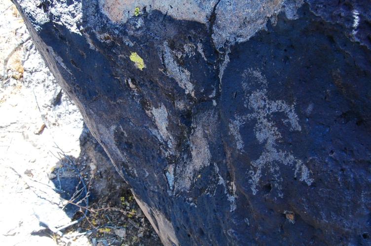
Rock art found near an agave roasting pit at the base of Tumamoc Hill.
They lived in dispersed villages of small brush huts built from a framework of saplings covered in grass and mud like “a giant upside-down basket,” said Thiel, who has taken part in numerous scientific digs along the river and elsewhere in his role with Tucson-based consulting firm Desert Archaeology.
There is no record of any permanent European residents here then, he said, but there was a chapel just east of Sentinel Peak — "A" Mountain long before the "A" — where visiting Catholic missionaries from nearby San Xavier del Bac Mission would drop in to conduct services and baptisms.
The small adobe “visita,” known for a time as Mission San Agustín del Tucson, was also used by locals to shelter from Apache raids, Thiel said. Its name was derived from S-cuk Ṣon, an O'odham word that means “black base” to those who used it to describe their home among the dark volcanic flanks of Sentinel Peak and Tumamoc Hill.
Thiel said crops grown near the Santa Cruz in 1776 may have included corn, wheat, squash, pumpkins, watermelons, beans, cotton, tobacco and peaches. The O’odham also raised cattle and sheep, hunted wild game and gathered cactus fruit, mesquite pods and wild greens from the desert.
Wheat and corn were ground on manos and metates, while mesquite beans were pounded with pestles into flour in mortar holes that can still be found at the base of Sentinel Peak. Stews and soups were prepared in small handmade jars, and meat was cooked in rock-lined barbeque pits.

Thiel
They discarded trash in the areas around their homes and buried their dead in nearby cemeteries.
Occasionally, Thiel said, O'odham men from the Santa Cruz River Valley and elsewhere would walk to the Gulf of California to collect salt and seashells using trails still visible today in the Gila Bend and Yuma areas.
Indigenous trade networks had brought Hopi and Zuni pottery to the Sonoran Desert, but in 1776, the residents of S-cuk Ṣon still had few Mexican or European goods, beyond the rare metal knife or needle or the religious items handed out by priests, Thiel said.

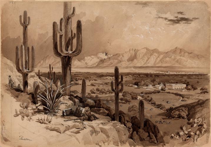
A drawing by John Russell Bartlett shows Tucson as it looked in July 1852 from the eastern flank of Sentinel Peak.
July 4, 1776, likely saw the O’odham busy in the fields or with domestic chores, while sentries from the group perched atop Sentinel Peak to watch for Apaches and the approach of summer storms.
It took days and, in some cases, weeks for news of the Declaration of Independence to spread through the 13 colonies. Thiel said word of the rebellion against Britain probably didn’t reach New Spain for months, and it might have taken years for Spanish soldiers on the kingdom’s northern frontier to finally learn about the conflict.
To the extent that the late-18th century Indigenous inhabitants of the area knew about the American Revolution, it probably didn’t mean much to them.
“O'odham do not think of their history in terms of the western calendar,” said David Martinez, an Akimel and Hia-ced O'odham professor of American Indian Studies at ASU, where he also serves as director of the Institute for Transborder Indigenous Nations. “July 4, 1776, actually has no cultural meaning for us.”
Now the weather
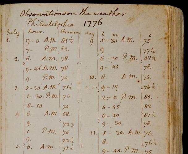
Thanks to some guy named Thomas Jefferson, we know what the weather was like in Philadelphia on the day the Declaration was adopted.
The future U.S. president from Virginia liked to travel with a thermometer and collect several daily weather observations, often starting around sunrise and ending in the late evening, with a measurement in the afternoon to capture the high for the day.
His handwritten temperature readings for July 4, 1776, show 68 degrees at 6 a.m. and 76 at 1 p.m., with no mention of rain — a pleasant summer day in the mid-Atlantic, particularly by modern standards.

Thomas Jefferson's handwritten weather observations from Philadelphia in the days leading up to the adoption of the Declaration of Independence.
No daily weather records exist for the Santa Cruz River Valley in 1776 — let alone any observations personally documented by an actual Founding Father. To reconstruct climate conditions from that period, scientists have to look to the trees growing high in the Santa Catalina Mountains and elsewhere across the Southwest.
“Conifer trees growing in our mountains — pines, fir, even spruce — record the large-scale changes in precipitation that affect our region,” said Kevin Anchukaitis, director of the world-famous Laboratory of Tree-Ring Research at the University of Arizona.
By measuring the annual growth rings of those trees, researchers can tease out signs of dry winters and wet monsoons, while the density of the wood offers clues about temperature variations.
“We build statistical models that relate ring width or wood density to the instrumental observations we have of precipitation and temperature, and then use those models to turn hundreds of years of tree-ring data into estimates of climate variability,” Anchukaitis explained.
According to an analysis by him and fellow tree-ring researchers Connie Woodhouse and Dave Meko, 1776 was “pretty close” to the long-term average in terms of drought, monsoon rain and summer temperatures, though it was generally cooler and wetter here back then than it is today.
Tree-ring reconstructions show slightly drier conditions in late spring and early summer of 1776, followed by a slightly wetter-than-average monsoon season. Summertime temperatures that year were on par with Tucson’s average during the middle of the 20th century, but roughly 5 degrees cooler than “the hot summers we’ve had recently,” researchers said.
“In the summer people probably slept outdoors, perhaps under ramadas,” Thiel said. “I think the heat was probably less oppressive then, (with) no asphalt and concrete to absorb and let off heat.”

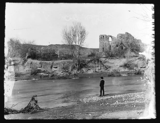
Ruins of El Convento along the Santa Cruz River, circa 1910. The adobe structure was part of a Franciscan mission complex built here at the end of the 18th century.
During the day, Indigenous residents could find shade beneath the cottonwood and willow trees they planted to stabilize the banks of the irrigation ditches they maintained branching off from the river. And to the north and south of the cultivated area, there were large mesquite groves where wood could be sustainably harvested, Thiel said.
“This is a pretty harsh desert landscape. Many visitors would have just as soon continued right on through there,” said ASU’s Crandall, who is also a member of the Yavapai-Apache Nation of Camp Verde. “But for O’odhams, this was a homeland, and it provided all the things that they needed. They were experts and continue to be experts on how to survive in this desert landscape.”
The remembering
Despite its existence as an Indigenous settlement dating back thousands of years, Tucson’s origin story is often told from a colonizer’s perspective. By most accounts, this place became Tucson after Jesuit missionary Eusebio Francisco Kino's first visit in the 1690s or when Spanish officer Hugo O’Conor chose a spot overlooking the east bank of the Santa Cruz as the future site of the Presidio San Agustín del Tucson in 1775.
As long-time research archaeologist Deni Seymour argues in a 2022 paper reexamining the community’s true birthplace, this way of thinking “places the focus on Spanish ‘improvements,’ constructions and events rather than acknowledging that Tucson was already settled by people with extensive irrigation canals that watered (what Kino himself described as) ‘splendid fields … of beans, watermelons and squash’ long before Spaniards arrived.”
While the colonizers from Europe brought disease, instability and an influx of goods from the outside world, Crandall said, the people who were already here “carried on as much as they could in their traditional lifeways.”
But the outsiders kept coming, until ignoring or resisting them became impossible.
Within a few months of O’Conor’s declaration establishing the Tucson Presidio, a vast expeditionary party — hundreds of men, women, children and their livestock, led by Juan Bautista de Anza and his Indigenous guides — trudged past the O’odham fields and villages along the Santa Cruz River on the way north and west to settle the San Francisco Bay.
A year later, in the autumn of 1776, Spanish troops from Tubac marched into the valley to begin construction of their new fort.

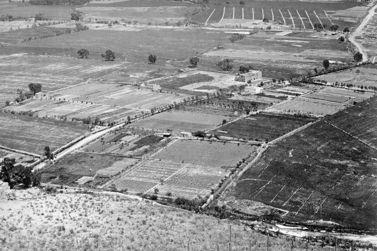
Cultivated fields surround the ruins of the San Agustín Mission in a photo taken from what is now known as Sentinel Peak along the Santa Cruz River, circa 1880.
The pace of change only accelerated after that. Wars were fought. Borders were drawn and redrawn. More people moved in, lured by silver and sunshine and the promise of a new frontier in a place far older than many newcomers understood.
Then came the railroad, the automobile, the airplane and the air conditioner. Across 250 years, the Kingdom of Spain’s Pimeria Alta was transformed into the United States’ Pima County, home to more than a million people, among them the descendents of those early farmers along our once-flowing desert river.
What’s left now is the remembering.
“Perhaps we can alter the narrative to more clearly convey that the place around which the city now sprawls was settled long before the arrival of Europeans,” Seymour writes in "Unveiling Tucson's Namesake: The Sobaipuri O'odham Village of San Cosme del Tucsón" from the Summer 2022 edition of the Journal of Arizona History. “The heart of Tucson was important to those who went before us, those who took care of the land that we now enjoy and consider our own, and who named it in their own language.”